Although Myton Hall dates from the late 17th century, the designed landscape was largely created in the 19th century by members of the Stapylton family after it became their principal residence. Set next to the River Swale and north of the village, it has expanded over time principally to the north and east. The early gardens surrounding the Hall, including pleasure grounds to the west and the walled kitchen garden to the south, have been incorporated into the later design. Although some of the former parkland to the north is now arable, it largely remains intact as do the shelterbelts surrounding it and the walled kitchen garden.
Estate owners
The manor of Myton is mentioned in documents in the time of Edward the Confessor, owned by three Anglo-Saxon lords. After the Norman Conquest, the manor was owned by the king and the Count de Mortain. It subsequently became the property of the Mowbray family, who in due course gifted the manor to the newly founded Abbey of St Mary in York.
The manor remained in the possession of the Abbey until its dissolution in 1539, when it became the property of the Crown. In 1591 Queen Elizabeth I granted a 40 year lease to William Cecil, Lord Burghley. Bryan Stapylton, the younger son of Sir Robert Stapylton of Wighill (north of Tadcaster), is thought to have acquired it about 1610 (VCH 1923, 157-160).
Myton remained in the ownership of the Stapylton family until the 20th century, when parts of the estate were sold to meet debts. The last of the male line of the Stapyltons died in 1933 and following his death, most of the remaining farms and village properties were sold. Some members of the Stapylton family continued to occupy the house, gardens, and the greater portion of the parkland until 1946, when the property was sold to Mr Lewis Albert Thomas, a farmer and company director. After his death in 1987, the property was purchased by Sir Ken Morrison.
Key owners responsible for major developments of the designed landscape and their dates of involvement:
Sir Bryan Stapylton 2nd Bt, b 1657 (1679 – 1727)
Sir Brian Stapylton, 5th Bt b 1712 (1752–1772)
Sir Martin Stapylton 7th Bt, b 1751 (1801 - 1817)
Martin Bree Stapylton, b 1771 (1817 - 1842)
Stapylton Stapylton, b 1798 (1842 – 1864)
Henry Miles Stapylton, b 1831 (1864 - 1896)
Early history of the site
The Myton estate seems to have been entirely agricultural land managed by tenants and provided food for the Abbey for its own use or for sale prior to the Dissolution. In the 1620s Bryan Stapylton is mentioned as lord of the manor. He appears to have commenced the building of a manor house at this time as he became embroiled in a lengthy dispute with his builder, which was not settled until 1639 (VCH 1923, 157-160). A structure called the ‘Old Hall’ with a date stone 1664 (Historic England List Entry No. 1314948) is situated at the southern end of the village but cannot be identified with certainty as being the original manor house. Sir Bryan Stapylton succeeded in 1679 and was probably responsible for building the existing house in the northern part of the village. The brass plaque placed above the entrance to the house is dated 1693 (Historic England List Entry No. 1189504).
The only reference to the grounds at this time is from a household account book dated 1701 that mentions a payment of one shilling to ‘the Gardener’s maid at Myton’ (NYCRO ZLQ MIC 65-70). Women were often employed to do weeding of gravel paths and kitchen gardens. Contemporary large-scale maps do not show any parkland, so the designed landscape was probably limited to gardens around the Hall, both decorative and productive.
The account book of Mr Sparke, the Land Agent, dated 1768-9, indicates that there was a well-stocked and productive kitchen garden and orchard by this time. It lists substantial purchases of soft fruit plants, flower and vegetable seeds, as well as fruit trees. These were being supplied by Telford’s nursery in York. The vegetable varieties include:
marrow, dwarf beans, winter beans, long podded beans, kidney beans, leeks, carrot, turnip, garlick [sic], radish, cabbages, cauliflower, chou de Milan, broccoli, kale, cucumber, endive (white and green), marjoram, chervil, parsley, and celery and four kinds of lettuces.
The list of fruit trees is no less varied: nectarines, peaches and named varieties of apple. The account for June 1769 included strawberry plants, 4 cherry trees and 12 Morello cherries, asparagus and peas. 600 quicks, 50 spruce fir and 550 ash trees of different sizes were purchased at the same time but we have no information as to where they were planted (NYCRO ZLQ MIC 3526-7).
The tithe map from 1849 (Figure 1) shows some features that may survive from this period including the ‘Long Walk’ (No. 62), a 5 acre strip of meadow leading from the front of the Hall which is referred to in a Survey of Myton dated 1798 (NYCRO ZLQ 53). A similar feature at Escrick Hall, lined with trees, was in place in the first half of the 18th century (Wickham 2018, 4).
The survey of 1798 for the Stapylton estates including Myton (NYCRO ZLQ 53) shows that the Hall and its surroundings totalled 96 acres and were listed as Hall Farm. The following were described as unoccupied, so part of the designed landscape:
1. Hall and courting 1r 26p
2. Kitchen garden 1a 32p
3. Pleasure grounds 2a 2r 22p
4 Green walk woody piece against the river 3a 3p
5. Back Garden 1r 17p
6. Back Garden Courting and Lane going to river 2r 14p
7. Barn, stables, fold yard, orchard and stack garth 1a 2r 25p
8. Walk before the stables 3r 7p
9. Orchard in 3 parts 2a 2r 35p
The remaining land was listed as either pasture or meadow.
Chronological history of the designed landscape
1801 – 1864Sir Martin Stapylton 7th Bt. inherited the estate in 1801. An account book from 1807 to 1814 notes the cleaning of fishponds in 1807 (possibly an earlier feature), the purchase of trees, pots and tools. From 1809 an under gardener, two garden men and three garden women were employed to assist the head gardener (NYCRO ZLQ MIC 3526-7). The York Herald for 11 July 1812 includes correspondence relating to a noteworthy tree in the gardens at Myton:
a peach tree which has both peaches and nectarines upon the same branch; and what adds to the above singular circumstance is, that the above branch has been neither inoculated or engrafted, as Mr Daglish, the gardener, can attest.
Sir Martin Stapylton died in 1817 and with him, the baronetcy became extinct. The estate however passed to his nephew Martin Bree, who took the name of Stapylton on inheriting. When he took over, account books show a substantial programme of alterations and improvements to the Hall, including building more impressive entrance gates to the estate (now named Myton Gates and Dowber Gates).
Work was also undertaken to update the designed landscape. In the gardens close to the house, what was previously described as ‘the green walk against the river’ was reduced in size and became part of the ‘back garden’. The pleasure gardens to the south of the hall were extended by taking up some of the area previously included in the ‘green walk’. The walled area devoted to the productive garden also received attention. In 1798, the ‘kitchen garden’ extended to one acre only, in 1849 the area of ‘gardens’ including both the ornamental and the productive areas covered over 4 acres. In 1817 draining tiles were laid around the summer house, new glass was put in the frames in the garden and tan bark (for hotbeds) was purchased. In 1818 soil was moved into the peach house, a joiner was paid for work on new greenhouses and straw was bought for ‘thatching the grotto’. More soil was obtained in order to ‘raise’ the flower beds in front of the Hall, possibly replacing the earlier courtyard listed in 1798 (NYCRO ZLQ MIC 3526-7).
Work was also taking place in the wider estate from 1817. The fishponds were again cleaned out and ‘the paddock in front of the stables was laid to grass’. 6000 quickwood [hawthorn] plants were purchased for hedging and in 1818, there was the first mention of the Park when a labourer was paid for weeding the plantation and replanting trees there. The plantations and park are identified for the first time in Joseph Walker’s account book for 1823 where he lists the land which Martin Stapylton holds in hand (NYCRO ZLQ 3526-7). The same features are represented and listed on the tithe map (Figure 1): Nos. 61 & 102 – Park; Nos. 103 to 106 – Plantations.
Trees were also obtained for planting around the new entrance. At the same time, between 1831 and 1840 Martin Stapylton began to sell timber from the estate. In 1831 he offered elm, willow, and poplar timber trees, larch and Scotch fir poles lying in the Plantation at Myton Hall (Yorkshire Herald, 31 October 1831. In 1833, ‘capital timber of ash, birch lying at the water side’ was on sale together with ‘several hundred trees of oak, ash, beech and crab trees standing in the hedgerows at Myton’ (Yorkshire Gazette, January 1833). This suggests perhaps that some field boundaries were being removed to form the extended parkland shown on the 1st edition OS 6” map, surveyed in 1852 (Figure 2).
In 1841 the Hall was put up for rent, with ‘extensive gardens in high condition’, several manors and the Home Farm (Yorkshire Gazette, 3 July). Martin Bree Stapylton died the following year and was succeeded by his eldest son Stapylton Stapylton. The whole contents of the Hall were put up for sale in April 1842 (Aris’ Birmingham Gazette, 18 April), suggesting that the estate had considerable debts. However by the end of the 1840s, the family had returned and were continuing to develop the estate.
The tithe map of 1849 (Figure 1) and the slightly later 1st edition 6” OS map (Figure 2) show the changes that had been made. The area behind the Hall (‘the back garden’, No 100 on the tithe map) was reconfigured as pleasure grounds, as was ‘the orchard’ (No 96 on the tithe map) which was surrounded to the north and east by ‘a plantation and walk’. The parkland has been extended to the north. The 1st edition OS map also shows at the front of the house, facing east, an oval shaped formal garden. The walled kitchen garden is shown to the south of the Hall.
By the mid-19th century the gardeners at Myton Hall were regularly winning prizes at local horticultural society shows, for a wide range of fruit and vegetables and flowers such as geraniums, fuschias, petunias, and hollyhocks, as well as cacti and greenhouse plants.
1865 – 1896Henry Miles Stapylton on inheriting the estate, embarked on an ambitious programme of rebuilding and general improvement. He had a strong interest in ‘scientific farming’ methods and improving livestock. He advocated the growing of sugar beet and using the most modern machinery and methods. In the course of a few years, the Home Farm was rebuilt to the plans of one of the model farms seen at the Great Exhibition and the stud farm was rebuilt to accommodate Henry’s horses and house his prize stallions. He had several new cottages built in the villages, each with its own garden, with access to a pure water supply.
To enhance the approaches to the Hall, a brick lodge was built on Hall Lane and gate piers and a stepped wall linked by a gate were placed at the junction of Hall Lane and Moor Lane. Henry also had the large and impressive iron bridge built over the River Swale in 1868 to replace the earlier ferry. An estate plan from 1870 (NYCRO ZN 74, Figure 3) shows the park extended to the east and a shelter belt plantation divided into clumps to accommodate the new kennels.
In 1869, Stapylton founded the Myton and Wass Floral, Horticultural and Poultry Show, held in the grounds of the Hall. He and his mother also exhibited flowers, produce and poultry at other local shows. The lists of prize-winning produce reported in the local press highlight the wide variety of fruit and vegetables produced by the kitchen garden. Amongst the list of decorative plants mentioned feature ‘magnificent palms’, fuschia, geraniums, lilies, asters and many others. Visitors to the Hall in 1877 commented on the ‘beautiful gardens tastefully laid out’. A garden fete held at Myton in August 1888 was reported as being held ‘in the beautiful gardens of Myton Hall’ with particular mention of the well-kept lawns on which tennis courts were marked out (York Herald).
The 2nd edition 6” OS map, surveyed 1891/2 (Figure 4) shows the park extended further to the east and the ‘New Plantation’ in place south of the Home Farm. On the new park boundaries are further plantations, including along the riverbank. The more detailed 25” OS map from the same time (Figure 5) indicates that the walled kitchen garden has been enlarged to the east and four large glasshouses are in place to the south of the main productive area, together with three smaller glass buildings.
Later historyOn Henry Miles Stapylton’s death the estate passed to his nephew Miles John Stapylton who undertook some refurbishment of the house in 1897 and 1898. It appears that he was declared bankrupt in 1920 and so put up part of the estate for sale on 16 December 1921. This included Church Farm, Plump House Farm and Old Hall Farm, together with four arable fields, Myton Pastures, accommodation land and assorted woodland, totalling 854 acres 2 roods and 30 perches. It is not clear which properties were actually sold on this occasion. A sale document of 1932 states that the Stapylton family owned the Hall, the Kennels, three farms and 131 acres of land at Myton.
Miles John Stapylton died in 1933 and by the end of that year, most of the properties belonging to the estate had been sold. The Hall with the gardens and adjoining buildings and also some 65 acres of the parkland (reduced to its 1852 boundaries on the east) continued to be occupied by Mrs Stapylton until 1946, when they were sold to Mr Thomas.
The grass verge of Hall Lane to the west outside the wall of the kitchen garden has been planted in recent years with a variety of conifer species. The area designated as parkland to the north of the Hall has been slightly reduced by the creation of the road to Helperby which forms the eastern boundary.
Location
Myton Hall is situated 3 miles (4.8km) east of Boroughbridge and to the south of Helperby in the Hambleton District of North Yorkshire. It lies in the village of Myton-on Swale on the south bank of the river Swale close to its confluence with the river Ure.
Area
The historic designed landscape at its greatest extent (from 1895) comprises approximately 70 acres consisting of the pleasure gardens and immediate grounds (8 acres) and the open parkland including woodland and boundary plantations (62 acres).
Boundaries
The boundaries of the gardens and grounds are: starting on the west, the river Swale, as far as the boundary with Myton Grange. The boundary runs west to east until it meets the road from Helperby past Myton Grange to Hall Lane, then turns north east along Hall Lane past the Keeper’s Cottage and former Lodge, then southward alongside a post and rail field boundary for approximately 500m, then south east along a field boundary and then south to meet Moor Lane. Moor Lane forms the east to west southern boundary and is bounded by a line of woodland. At the junction with Hall Lane and the Village Street, the brick wall enclosing the walled garden of the Hall provides the boundary between the churchyard and the garden and runs on to meet the river.
Landform
The underlying bedrock geology is Sherwood sandstone overlain with alluvium drift geology. This gives rise to deep, permeable, loamy, well-drained brown soils favourable to arable crops.
Setting
The estate is situated on the floodplain next to the south bank of the river Swale. It is surrounded by intensely farmed arable farmland and patchy clumps of woodland along the riverside. The estate landscape also includes an associated area of parkland and tree-lined avenues. It is described in the North Yorkshire Landscape Character Assessment (2011) under landscape classification no 22: Ure floodplain. The land is flat generally below 20m AOD with the Hall at 19m AOD.
Entrances and approaches
Gate piers and flanking walls at the junction between High Lane and Hall LaneTwo round stone pillars with a curved stone wall on either side flank Hall Lane (SE 457 676). There is no evidence of fittings for a gate. Documentary evidence in account books for 1817 suggests the stone may have come from Byland Abbey. On modern maps this entrance is named Dowber Gates.
Entrance Gates and PiersOn Hall Lane, to the north of a previous, now disused entrance, there are 2 stone gate posts set in a brick wall linked by a gate providing access to Myton Hall (SE 441669). This was previously a service entrance giving access to the Stable Block. A matching brick-built gate pier sits at the wall return.
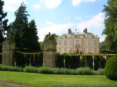
Gate piers, wall and railings to the east of Myton Hall (Grade I, NHLE 1151270)Gate piers of rusticated stone with laurel wreath decoration each one surmounted by an eagle (SE 441668). Flanked by iron railings on a low wall and linked with matching gates. Prior to 1907 formed the main entrance to the house.
Gate piers and wallTwo brick pillars and stepped 5ft brick walls topped with sandstone coping, are situated south of Myton Hall on either side of Hall Lane at the junction with Village Street next to a roofed bus stop (SE 440666). There is map evidence for the existence of a gate at this point from 1852 to 1907.
Garden entrance from Village Street to the south-west of Myton HallTwo brick piers with sandstone coping the same height as the brick wall (2.5m) are linked by solid wooden gates and provide access from the Walled Garden to Village Street (SE 439 666). There is a suggestion of a later widening of the entrance evidenced by different brickwork on one pillar. Map evidence for the existence of this access dates from 1893.
Myton GatesAt the junction of Moor Lane and High Lane, there are 2 stone pillars with double capstones on each side of the road with a stone wall curving up to a taller pillar with ball finial on the verge(SE 463 665). On modern maps, these are identified as Myton Gates.
Carriageway/DriveHall Lane, a tree-lined tarmac road running from the junction with High Lane through Dowber Gates to the main entrance of Myton Hall and turning south west to the junction with Moor Lane on the east and Village Street to the west. The trees appear to be relatively recent plantings.
Principal buildings
Myton Hall (Grade I, NHLE 1189504)The Hall is dated 1693 on a brass plaque above the entrance but this is thought to have been reset. Pevsner suggests a date in the 1680s ( 1981: 262). The English Heritage listing mentions a possible attribution to John Etty (1634-1708). Brick-built with plinths and stuccoed white with some alterations in the late 18th century and later.
StablesThe stable block lies to the north of the Hall. It consists of two rectilinear ranges separated by a courtyard.
AviaryAn aviary is depicted to the west of the stable block on the 1892 OS map. A second aviary is depicted as a small structure within an enclosure to the west of the Kennels. These may have been devoted to raising game birds. There are no subsequent records of these structures.
SummerhouseThere is map evidence for a small structure placed in the angle formed by the south and west walls of the pleasure gardens in the wooded area lying behind them. An account book for the years 1817-1826 lists paying for draining tiles laid round it. A structure is still present in this position.
LodgeA two-storey gabled brick-built cottage on the south side of Hall Lane. Above the door is a cartouche bearing the monogram of Henry Miles Stapylton, a Saracen’s head and the date 1865. In the 1871 census, this property is referred to as Myton Lodge and is inhabited by John Benson, a stud groom, but is subsequently referred to with the adjacent property as The Kennels and inhabited by a succession of gardeners.
KennelsThis complex of structures appears for the first time on an estate plan drawn up in 1870. It is situated on land immediately behind the Lodge, and from the available census evidence incorporates a dwelling occupied for the most part by the estate gamekeeper. The property is named as Myton Kennels on the 1892 6in OS map and in 1907 is labelled Gamekeeper’s Lodge.
The grottoAmongst the list of materials purchased in 1818 for refurbishment work on the house and the estate there is an entry for ‘3 ½ sheaves of straw for thatching the grotto at the fishponds’. This is the only reference to such a structure and it is not referenced on any surviving map.
Gardens and pleasure grounds
East of the Hall and facing Hall Lane, south of the present tree-lined drive, there is a formally planted area. This comprises an oval lawned area, with small cushion flower beds within it. The lawned area is circled by a walkway. Access from the Hall is from a paved terrace with a short flight of steps. Formerly, an access onto Hall Lane existed via the formal entrance gates. The 1910 map suggests that this entrance had previously fallen out of use. Today, the gates are not in use, and a hedge has been planted inside the length of the railings and gates.
Behind the Hall to the south and southwest lie the pleasure grounds. A perimeter path runs around the outside of the southern area with a fountain indicated in the SE corner (Figure 5). The southwest section has a path that runs north-south from the western part of the Hall to the glasshouse complex. At its southern extent, there is a wall and bank separating it from the Church and graveyard.
Kitchen garden
The kitchen garden is situated to the southwest of the pleasure garden from which it is separated by a 3 m brick cross wall with a sandstone coping. It extends down to the Village Street to the south, the ‘back garden’ to the west and Hall Lane to the east. There is an existing access to the Village Street through wooden gates in the south wall first depicted in 1893. Access from the Hall is from the pleasure garden. The boundary walls are of red brick, Flemish bond, 2 m in height with stone capstones. The boundary wall with Hall Lane is reinforced at regular intervals with brick buttresses.
By 1891/2, it had been expanded (Figure 5) with new glasshouses. A whitewashed wall (c. 4m high) still exists, dividing the garden east to west. Its air vents in the upper section are still visible today, indicating the former heated greenhouses.
Park and plantations
The parkThis dates from the early 19th century with significant expansions in the later part of that century. At its height, it covered 140 acres (Figure 4). Today, the parkland includes an area north of Myton Hall, lying between Hall Lane and the boundary of Myton Stud Farm. The boundary to the west is formed by the wooded river bank. To the east, the boundary is marked by the tree-lined road from Hall Lane to Helperby through Myton Grange. Most of the area is open pasture with the exception of one clump of mature, deciduous trees to the west and a few scattered trees.
The remainder of the parkland lies to the east of the Hall and is contained within the area defined by Hall Lane and Moor Lane and the former boundary of the Long Walk. The Long Walk only survives today vestigially as the northern boundary consisting of a post and rail fence between the park and agricultural land to the east. Along the eastern boundary runs a discontinuous line of mature deciduous trees suggesting the remnants of a former shelter belt. One large clump of trees is visible in the centre as well as a few scattered trees amongst which feature oaks, beech and chestnuts.
The western boundary of the park, adjacent to Hall Lane is formed by a grass verge dotted with mature trees. A ha-ha runs northeast southwest parallel to Hall Lane from the entrance to the Hall and curves round to enter Fishpond Plantation. The ha-ha consists of a brick wall with a ditch. The wall is topped with a horizontal line of bricks. A change in the form of the bricks suggests an extension to the original ha-ha towards Fishpond Plantation. Today, an entrance to the parkland from Hall Lane is compatible with the site of the start of the historical Long Walk. It is accessed by a stone platform alongside a curved brick wall with a stone coping. Beyond the ha-ha to the north, the park is enclosed by iron railings.
Fishpond PlantationThis extended along Moor Lane forming part of the southern boundary of the park with a total area of 4.775 acres. Today it survives as a narrow belt of mixed woodland about 500 m in length.
Water
FishpondsThere has been a series of small ponds next to Moor Lane, the largest being about a third of an acre.
Books and Articles
Pevner, N. 1981. The Buildings of England. Yorkshire: The North Riding. Yale University Press
Victoria County History. 1923. A History of the County of York, North Riding. Vol 2. London
Wickham, L. 2018. Historic Report on Escrick Hall. Yorkshire Gardens Trust [https://www.yorkshiregardenstrust.org.uk/escrick]
Primary Sources
North Yorkshire County Record Office (NYCRO)ZLQ Stapylton Family of Myton Records 16th-20th century
MIC 3526-7 Account Books, 1768-9 & 1807-14, 1823
ZLQ 53 Survey of Myton and other estates belonging to the Stapylton family, 1798
ZLQ 74 Plan of the Myton Estate, 1870
National Archives (NA)PROB 11/1354/133 Will of Rev Sir Martin Stapylton of Myton Hall, Yorkshire, 1801
PROB 11/1961`/303 Will of Martin Stapylton of Myton Hall, Yorkshire, 1842
IR 30/42/263 Tithe Map of Myton on Swale, North Riding of Yorkshire, 1849.
Maps and Plans
Ordnance Survey 6” 1st edition, surveyed 1852, published 1855
Ordnance Survey 6” 2nd edition, surveyed 1891/1892, published 1895
Ordnance Survey 6” revised 1907, published 1910
Ordnance Survey 6”, revised 1951, published 1953
Ordnance Survey 25”, 2nd edition surveyed 1892, published 1893
Ordnance Survey 25”, revised 1907, published 1910
Figure 1 - Tithe Map of Myton on Swale, 1849 (TNA IR 30/42/263), marked with the areas of the designed landscape. Copyright: The National Archives.
Figure 2 - Ordnance Survey 6” 1st edition, surveyed 1852, published 1855 showing the new parkland and detail of kitchen gardens. Reproduced with permission from National Library of Scotland.
Figure 3 - Plan of the Myton Estate 1870 (NYCRO ZLQ 74) showing extended parkland and new Myton Grange development. Source: North Yorkshire County Record Office.
Figure 4 - Ordnance Survey 25”, 2nd edition surveyed 1892, published 1893 showing the completed parkland. Reproduced with permission from National Library of Scotland.
Figure 5 - Ordnance Survey 25”, revised 1907, published 1910 showing the developments in the kitchen garden. Reproduced with permission from National Library of Scotland.
")
, marked with the areas of the designed landscape.")

 showing extended parkland and new Myton Grange development.")

