The designed landscape of Skutterskelfe Park takes full advantage of its natural surroundings, both within the estate boundaries and the borrowed landscape of the Cleveland Hills beyond. The former was created in the second half of the 18th century to surround a contemporary mansion, incorporating the key natural features of the River Leven and streams, Stell and Carr Stell and the highpoint, Folly Hill. When the Hall was rebuilt in the 1830s by the architect Anthony Salvin for Lord Falkland, this was retained and enhanced through further woodland planting and a new terraced garden adjacent to the Hall. The parkland and much of the woodland remains, as does the structure of the walled kitchen garden and formal terraced area.
Estate owners
The Gower and then the Lindley families owned the manor in medieval period. It passed to the Layton family of nearby Sexhow Hall through marriage who sold the estate to the Bathurst family of Clint before 1659. Charles Bathurst died childless in 1743 and his sisters, as co-heirs, sold Skutterskelfe to General George Cary in 1754. Cary owned the neighbouring Rudby estate through his marriage to Isabella Ingram. On his wife’s death in 1799, their daughter, Lady Amherst, inherited these estates.
Following the death of Lady Amherst in 1830 the estate passed to a relative, Lucius Cary, the 10th Viscount Falkland. Lord Falkland died in 1884 and Skutterskelfe Hall was inherited by his brother who died 2 years later and then their nephew, Byron Cary. The Hall was put up for sale in 1898 when it was bought by the Ropner family, who owned it until 1950. The estate was divided up in the following years and sold to a number of owners.
Early history of the site
The manor of Skutterskelfe had three owners including the King in the Domesday book. For its size of 2 carucates and 2 oxgangs (c. 250 acres), it was a relatively rich manor in terms of tax raised (http://opendomesday.org/place/NZ4807/skutterskelfe-hall/, consulted 10 October 2017). The possible site of the medieval village has been noted at NZ 485 069 (NYCC HER: MNY592), where a hollow way survives with possible remains of building platforms on either side of it. The first evidence of a manor house, belonging to Richard Lindley, was in 1466 (PRO 1897, 506). In the 1673 Hearth tax survey, the manor house had 9 hearths and the owner was Theodore Bathurst (c. 1646-1697).
1.3 Chronological history of the designed landscape
1.3.1 1754 - 1808
Theodore’s son, Charles (d1724) or more likely his grandson, also Charles, was responsible for the building of the Hall before 1743 (Figure 1) depicted in Graves (1808, 172-3). A description of the Hall (formerly named Leven Grove) and surrounding landscape is given by Graves (1808, 173-4):
Leven-Grove, the seat of the Right Hon. Lady Amherst; which stands on the northern bank of the river Leven, on rising ground, and commands a pleasing prospect over a fertile and richly cultivated country. The house is a modern edifice, erected by the Bathursts, after they became owners of the estate; but has since received considerable improvements from succeeding proprietors. It is sheltered on the north and east by thriving plantations. The winding river gliding peacefully down its course, with its sloping banks richly ornamented, appears immediately in front: while the verdure of fertile meadows, the scattered trees and rich inclosures all conspire to variety to the scene, and impose an aspect of dignified retirement on the whole. Whorl-Hill, and a range of mountains on the south, with the rising grounds of Busby and Arnecliffe cloathed with wood, form a pleasing contrast to the cultivated lands, and terminate the view.
An estate map of 1808 (Figure 2, NYCRO ZNT) shows the Hall with plantations to the east and to the north on the other side of the Rudby to Stokesley Road. Within the woodland to the east is a lake or ‘Fishpond’, formed by canalising and damming Carr Stell, a tributary of the River Leven, between Sketterkelfe Bridge and Rookery Bridge, the latter carrying the carriageway over the stream. The walled kitchen garden to the northwest is divided into two sections with paths running around the outer edge. There is a structure in the centre, possibly a well as a pump is marked in this position on later maps. There is another structure on or next to the western wall that may be the hot house mentioned in 1830 (see below). The western half of the garden appears to have four beds presumably for soft fruit, vegetables and possibly cut flowers and the eastern half may well have freestanding fruit trees. Directly north of the Hall are more planted areas, possibly remnants of previous productive gardens (Figure 3).
There are pleasure grounds to the west, with borders around the edge of possibly a lawn with island beds (Figure 3). A gravel path leads south to the wooded area called ‘Bank’ next to the River Leven. The path then makes a circuit around this area that is later called ‘Flower Bank Wood’ (Figure 4). To the south of this is a ‘Grass Walk’ following the river on the western side to the bottom of Mill Field. On the opposite bank is an avenue of trees. There are three more small plantations around the northern and western edges of the southernmost field named ‘Horse Park’.
Further west is a small area of parkland called ‘Lawn’, measuring about 32.5 acres and containing the coach road to the Hall from the western entrance. The Stell stream runs through it, canalised and feeding a small D-shaped pond, which is surrounded by trees. To the north is a small clump of tree and further south a large circular tree clump. There is a narrow shelterbelt of trees running along the northern edge of the ‘Lawn’ next to the public road and continuing along ‘Little West Field’ before turning south towards ‘Folly Field’. There is a further small plantation on the western side of Folly Field. A footpath leads from the Coach Road to Folly Hill with an avenue of trees. The hill was described as ‘a conspicuous seamark, which may be seen at the distance of twenty leagues upon the German Ocean’ (Baines 1823, 544).
No designer has been identified as being responsible for this landscape. Lady Amherst and her family though had a gardener, Arthur Douglas (1747 - 1831), who served them for fifty years according to the inscription on his gravestone at Rudby church (http://northyorkshirehistory.blogspot.co.uk/2013/06/people-of-hutton-rudby-in-c1819.html, consulted 26 October 2017).
1830 - 1898
On inheriting the estate, Lord Falkland immediately put it up to let:
The Vale of Cleveland in Yorkshire, Leven Grove, the late residence of the Dowager Lady Amherst, deceased – To be let, the Mansion House which is placed in a beautiful situation with a convenient quantity of meadow land. The gardens are spacious and well stocked with hot house and wall fruit. (The Morning Post, 18th September 1830)
In December of that year, Falkland married Amelia Fitzclarence, the illegitimate daughter of King William IV and decided to rebuild the Hall at Skutterskelfe as a suitable seat:
We understand that Leven Grove, the seat of Viscount Falkland, in this county has for some months been undergoing considerable improvements. The mansion has been, we hear, rebuilt in the most modern style, at the cost of his Majesty, who has made a gift of it to Viscountess Falkland, his Majesty’s youngest daughter, in consequence of the Noble Viscount declining to accept of any pecuniary appointment under government (The Yorkshire Gazette, 12th October 1833).
He hired the architect William Salvin in 1831 and an undated letter from him to George Brigham, his steward, show his plans:
I have recd your letter and the plans – all the old square stone House is to come down – So let it be taken down immediately – Your plan is not a bad one and will be followed in a great degree –
The new House will be placed further back than the old one and extended 33 feet more to the west – I wish to have the road turned as it is in your plan…As if I can succeed in doing this I shall always have the stables &c &c stand exactly where they are instead of being obliged to move them for the sake of procuring a turn for carriages.In short I wish to adopt your plan as far as relates to the road – Pray measure everything accurately with Mr Parr and let Mr Salvin hear from him and let me hear from you as soon as possible…Let the old House be taken down completely – the offices remain – Let me hear from you as soon as you can but think the thing well over and consult and measure the distance so as to arrive at the exact spot where I have said I will have the door, with Mr Parr, I have great confidence in him – I mean that the centre of the near door should be 17 ½ feet further westward than the centre of the old one…
Falkland
PS…Pray send for Beckwith and tell him to set as many men as he can to work the stone, Mr Salvin wishes the stone to be got forward that we may make up for lost time (DCRO D/X 107/151)
The new mansion was completed in 1838, however Lord Falkland was in Nova Scotia from 1840 to 1846 and then Bombay from 1848 to 1853, so little further work was done:
Leven Grove, the seat of Viscount Falkland, is a superb modern edifice in the Grecian style, erected in 1831, in the sylvan and romantic vale of the Leven, on the site of the original mansion of the Bathursts. This elegant building is surrounded by plantations, and commands from the principal tower splendid views southward, of the great Cleveland range…The gardens and pleasure-grounds are extensive; but the stables, outhouses, and even the interior of the hall, are greatly neglected, owing to the non-residence of the noble owner, now Governor of Nova Scotia (Walker Ord 1846, 476).
The tithe map of 1838 (NA IR 30 42 337) shows that while the areas known as Lawn, Little West Field, Folly Field, Mill Field, Horse Park, Hill Orchard and High Pasture were laid to grass, they were rented as pasture. Lord Falkland is the occupier only of the Hall, immediate gardens and plantations amounting to 11.5 acres and the southern part of Folly Field (NA IR 29 42 337). By 1853, apart from Horse Park, these areas had been identified as parkland on the Ordnance Survey map surveyed that year (Figure 4). By this time, the avenue along the eastern stretch of the river had developed into ‘Philip Wood’. The other significant developments to the designed landscape by this time, are the terraced garden (possibly with fountain) immediately to the west of the new Hall (Figure 5) and the extension north of Flower Bank Wood to just south of the coach road. The eastern entrance has been moved to form a straight line for the carriageway and is now called the Avenue. East of the Hall there is a building in the southwest part of Rookery Wood that is in the area where the icehouse is located on later maps (Figure 6).
The house was renamed Skutterskelfe Hall in 1855. By 1892, the parkland had been extended west to Rudby by incorporating Folly Hill Field and the avenue to Folly Hill had been reinstated (Figure 7). This may have been because it was a focal point in the landscape, the site of a Bronze Age round barrow that had been excavated in 1889 by Canon Atkinson, who described his finds in the local press (NYCC HER: MNY583). The gardens to the north of the Hall had been modified with the construction of the new stable block (Figure 5) and glasshouses added both inside and outside the walled kitchen garden. The former lake or ‘Fishpond’ has reverted to its natural shape as the watercourse, Carr Stell, feeding the River Leven.
Byron Cary decided to let it in 1894 and it is described thus:
Skutterskelfe Hall Yarm with shooting over the estate of about 2000 acres, and capital trout fishing, to be let on lease. The excellent and commodious Mansion House is placed within beautiful ornamental pleasure grounds, and is surrounded by a finely timbered park...There is capital stabling for 12 horses, outbuildings, large walled kitchen garden, and gardeners and keepers’ residences; about six miles of fishing in the river Leven, which intersect the park and estate (The Lincoln, Rutland and Stamford Mercury, 6th July 1894).
Later history
The Ropners made some additions to the estate before 1913, including building a lodge by the western entrance (Figure 8) and adding to the glasshouses in the kitchen garden (Figure 9). A pump house was built to allow Skutterskelfe Hall to be the second house in the country, Cragside in Northumberland being the first, to have electricity (current owners of Pump House, personal communication).
In 1950 the estate was offered for sale in lots including the following (NYCRO K):
Skutterskelfe Hall and Grounds (14.64 acres)
A charming stone built Georgian residence pleasantly situated with a fine prospect of the Cleveland Hills to the South. Standing well back from the main road and approached by an attractive wooded drive from the East.
The grounds are well planned with pleasant gardens overlooking open parklands and variegated woodland.
The Garage Yard and Stable Block including a cottage (0.326 acres)
Comprising a useful range of brick built buildings situated at the rear of the hall and approached from the main road from Hutton Rudby to Stokesley.
The Hall Gardens including a cottage (2.350 acres)
The gardens have frontage on to the road from Hutton Rudby to Stokesley and contain some very fine vineries and green houses and two useful ranges of brick outbuildings.
A further range of brick and tile buildings lies to the east of the gardens and includes a cottage
The buildings comprise: Peach House, 2 Tomato Houses, Cucumber House, 2 good vineries, Potting Shed, 2 Boiler Houses, Tool House, Store House Loam Sheds etc
The buildings to the east of these include: 5 loose boxes, coach house, 2 small stables with loft over, and attractive gardener’s cottage.
The range grouped around a small framed yard includes: Boiler House, Gardeners Room, Wash House 2 Mushroom Houses Store etc.
Hall Lodge and 8 acres of parkland
In 2001, the by now renamed Rudby Hall was put up for sale and was described as the following (NYCRO K):
Rudby Hall occupies one of the finest sites in the area, elevated above rolling parkland which descends to the banks of the River Leven and with far reaching south facing views towards the Cleveland Hills. The gardens and grounds… retain magnificent Wellingtonia and Cedar of Lebanon trees.
On the west side of the house a wide sheltered stone paved terrace fronts the kitchen and beyond level terraced lawns are protected by the high south facing brick wall of the original kitchen garden which is covered in climbing roses.
Location
Skutterskelfe Park and Hall lies adjacent to the hamlet of Skutterskelfe, 1 km (0.75 miles) east of Hutton Rudby and 4.5km (2.75 miles) west of Stokesley.
Area
The historic park and garden (Figure 8) covered about 60 hectares (150 acres).
Boundaries
The park is bordered to the north by the Hutton Rudby to Stokesley Road running from that road’s junction with Holme Lane at NZ 475 071 to the eastern entrance at NZ 487 071 and includes the small plantation to the north at NZ 482 072 and White House Plantation. The western boundary follows the line of the former Folly Field to NZ 475 068 and then continues from NZ 480 067 to Horsepark Wood. The River Leven forms the southern boundary until the start of Philip Wood to NZ 485 067 when the river once more is the southern extent. The eastern boundary starts at the entrance on the public road and follows the line of the former ‘High Pasture’ down to Leven Cottage and its woodland at NZ 487 066.
Landform
Skutterskelfe Park lies within the valley of the River Leven and a large meander loop runs through the parkland. The Hall lies on its northern bank at 64m AOD, slightly lower than the surrounding landscape to the west that ranges from 68m AOD to Folly Hill at 92m AOD. On the eastern and southern side of the Hall, the land ranges between 50 and 60m AOD. The underlying geology is Mercia Mudstone Group overlain with deposits of sand and gravel. The western parkland and area immediately around the hall has slightly acid loamy and clayey soils with impeded drainage. The southern section near the river has slowly permeable, seasonally wet, slightly acid but base-rich loamy and clayey soils.
Setting
The slope from the Hall down to the River Leven and across its valley affords exceptional views of the Cleveland Hills. The estate lies in the Hambleton District Landscape Character Area of Leven Valley that is mainly large-scale intensive arable farming with the river Leven, surrounded by mature woodland, running through it.
Entrances and approaches
North Lodge and Gateway [Listed Grade II NHLE: 1294276]
Lodge built in the early 20th century but the entrance dates from before 1808. The carriageway from here is described as the ‘Coach road’ on the 1808 map.
Eastern entrance from Stokesley Road
Constructed probably between 1831 and 1839 to replace an earlier entrance further west that is shown on the 1808 map. The carriageway is called ‘The Avenue’ and passes over Rookery Bridge en route to Hall.
Principal buildings
Rudby Hall [Listed Grade II* NHLE: 1150627]
Built between 1831 and 1839 and designed by Anthony Salvin.
Briardene [Listed Grade II* NHLE: 1150627]
A service building to the Hall, it was listed together with the Butler’s Pantry and Rudby Hall when it was previously two dwellings.
Stables
Dates from after 1853 and replaced earlier block next to the Hall.
Pump House [Listed Grade II NHLE: 1150628]
Built early 20th century to provide electricity for the Hall.
Icehouse
Possibly dates from remodelling of grounds in the 1830s as not marked on earlier map of 1808. It is not shown on the 1913 and subsequent OS maps and the site is now in the garden of the property, Briardene.
Gardens and pleasure grounds
The pleasure grounds were west of the Hall. By 1808 there was a triangular section just south of the walled kitchen garden, with borders and central area possibly laid to lawn with island beds. Following the rebuilding of the Hall in the 1830s, a new terraced garden, containing a fountain, was built to the south of this (Figure 6) Along the western side of both these gardens is a high brick wall that possibly dates from the earlier pleasure grounds shown on the 1808 map. The terrace walls and balustrade, garden wall and gate piers are now listed Grade II (NHLE: 1189400).
Kitchen garden
Northwest of the Hall and extant by 1808, it was divided into four quadrants with a pump in the middle section (Figure 6). During the 19th century and early 20th century, it was further developed with more glasshouses along northern wall that included a boiler house behind the western one. Outside was a further glasshouse with attached boiler house. Within these glasshouses were a peach house, two vineries, two tomato houses and a cucumber House.
Park and plantations
The park in the late 18th century consisted of the area of c. 32.5 acres known as the Lawn. It did not reach its maximum extent of 60 hectares until the end of the 19th century. The Rookery, White House and Bank plantations, together with Horsepark Wood date from before 1808. Between 1839 and 1853, Bank plantation (now Flower Bank Wood) was extended to the south and north and Philip Wood was added.
Water
East of the house a long narrow lake, depicted in 1808 (Figure 2) and named ‘Fishpond’ on the 1856 6” Ordnance Survey map, was formed by canalising and damming Carr Stell. It extended between Skutterskelfe Bridge and Rookery Bridge. By 1892 the lake was removed and the stream had reverted to a very narrow channel (Figure 7).
A small D-shaped pond lies within a small woodland clump in the parkland west of the Hall, depicted in 1808. The Stell stream, canalised on its northern side, feeds into it then flows out southeast across ‘Lawns’ (Figure 2). The pond, which is still extant, may have been used as a reservoir to supply water to the house and walled garden and later to feed to the ornamental pond and fountain in the terraced garden.
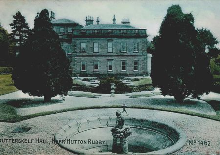
The circular pond in the formal terraced garden west of the house is depicted and labelled fountain on the 1894 25” Ordnance Survey map (Figure 6). Its ornamental form and central statue can be seen in a photograph of the early 20th century (Figure 5). The pond is now dry and used as an ornamental flower bed.
Books and articles
Bulmer, T. 1890. History, Topography and Directory of North Yorkshire. Preston, T. Bulmer & Co. and T. Snape & Co.
Baines, E. 1823. History, Directory and Gazetteer of the County of York Vol II. Leeds, Edward Baines.
Graves, J. 1808. History of Cleveland. Carlisle, F Jollie & Sons.
PRO 1897. Calendar of the Patent Rolls, Edward IV 1461-1467. London, HMSO.
Walker Ord, J. 1846. The History and Antiquities of Cleveland. London, Simpkin and Marshall.
Primary sources
North Yorkshire County Record Office (NYCRO)
ZNT A Map of Rudby Estate belonging to the Rt Honble Lady Dowager Amherst, 1808
K Sale brochure for The Skutterskelfe and Sexhow Estates, Sanderson, Townend and Gilbert 1950
K Sales Brochure for Rudby Hall, Jackson Stops 2001
National Archives (NA)
IR 29/42/337 Tithe apportionment of Skutterskelfe, 1840
IR 30/42/337 Tithe map of Skutterskelfe, 1838
Durham County Record Office (DCRO)
D/X 107/151 Letter from Lord Falkland, undated. Transcription from http://northyorkshirehistory.blogspot.co.uk/2012/12/chapter-10-1831-mr-barlows-first-year.html, consulted 13 October 2017
Newspapers
The Morning Post
The Yorkshire Gazette
The Lincoln, Rutland and Stamford Mercury
The Yorkshire Post and Leeds Mercury
Maps
Ordnance Survey 6” 1st edition, surveyed 1853, published 1856
Ordnance Survey 25” 1st edition, surveyed 1892/3, published 1894
Ordnance Survey 6” 2nd edition, surveyed 1892/93, published 1895
Ordnance Survey 25” revised 1913, published 1914
Ordnance Survey 6” revised 1913, published 1920
Figure 1 - Drawing of Leven Grove in Graves (1808, 172-3)
Figure 2 – Leven Grove estate from ‘A Map of Rudby Estate belonging to the Rt Honble Lady Dowager Amherst, 1808’ (ZNT). Source: The North Yorkshire County Record Office.
Figure 3 – Leven Grove pleasure grounds and kitchen garden from ‘A Map of Rudby Estate belonging to the Rt Honble Lady Dowager Amherst, 1808’ (ZNT). Source: The North Yorkshire County Record Office.
Figure 4 – Leven Grove park and garden on 1st edition OS map, surveyed 1853. Reproduced by permission of the National Library of Scotland.
Figure 5 – Skutterskelfe Hall terraced garden, early 20th century. Source Rudby Hall.
Figure 6 – Skutterskelfe kitchen garden and pleasure grounds from OS 25” 1st edition, surveyed 1892/3, published 1894. Reproduced by permission of the National Library of Scotland.
Figure 7 – Skutterskelfe Park from OS 6” 2nd edition, surveyed 1892/93, published 1895. Reproduced by permission of the National Library of Scotland.
Figure 8 – Skutterskelfe Park from OS 6” revised 1913, published 1920 Reproduced by permission of the National Library of Scotland.
Figure 9 – Skutterskelfe Hall kitchen garden and pleasure grounds from OS 25” revised 1913, published 1914. Reproduced by permission of the National Library of Scotland.
.")
.")
.")


