This text is a summary of a piece written for the Aske Hall Landscape Management Plan prepared by Scott Wilson Ltd in 2003 to which Janette Ray and Val Hepworth contributed the historical analysis as the basis for the plan, most of which was compiled from the Zetland/Dundas archive in the custody of the North Yorkshire County Record Office [Ref: ZNK] and from family records at the house. Please note that the estate is not open to the public, but parts can be seen from public rights of way.
Introduction
Aske Hall is just outside the North Yorkshire market town of Richmond. The grounds include terraced lawns, a walled garden, a massively scaled Gothick folly, detached pleasure grounds in Lowe Wood with cascades, woodland walks, parkland attributed to Capability Brown and a small lake with Roman-style temple, together with an eye catcher known as Oliver Ducket beyond the modern park boundary. The whole composition works in concert with the mansion at its centre.
The landscape is Grade II* status on the Historic England Register of Historic Parks and Gardens of Special Historic Interest. The house itself and the Temple behind the house are Grade I listed buildings and the landscape provides the setting for a further twelve listed buildings.
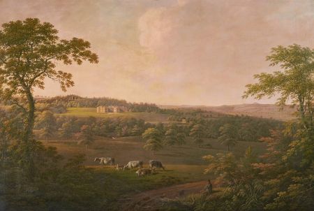
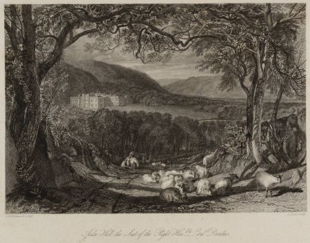
Aske has been painted and recorded by a variety of artists. The house is recorded in Samuel Buck’s Yorkshire sketch book, the wider estate by J.W.M. Turner, who painted views on his 1816 Tour of the North, by the Yorkshire born artist George Cuit who painted the scene and setting from several angles at the beginning of the 19th century, and a variety of other topographical artists.
The estate was also mapped better than many others by surveyors as a basis for design alterations proposed by the various owners. Most of the map records are in the Zetland Archives, deposited at the North Yorkshire County Record Office [Ref: ZNK].
Stages in the development of the estate landscape
The house and lands were the property of the Ask family up to 1510 and thereby giving the estate its name. At Aske, the last of their line died out in 1510 and the property passed around 1522 to the Bowes family who owned extensive properties in the north of England. They constructed a Pele Tower at Aske. Such structures were essentially places of refuge, built along the English and Scottish borders, in the Scottish Marches, and in the North of England, mainly between the mid-14th century and about 1600. Importantly, the siting of this settled the position of the present house which still incorporates the Tower.
The present footprint was, however, essentially established by the Wharton Family who owned Aske between 1611-1727. They built the formal established gardens round the house and the terrace walk along the south-east front, which has been an enduring design feature ever since. Enclosed courts were built around the house but beyond these the landscape was an agrarian one documented on a map made by Robert Kirkham in 1720.
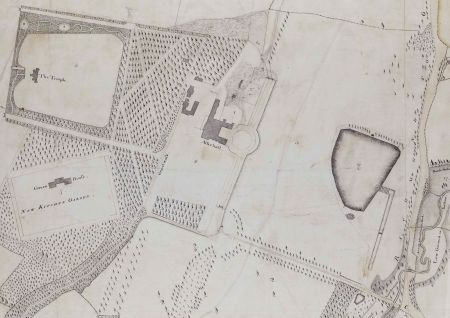
The property passed to Sir Conyers D’Arcy in 1727 and during his tenure the house was improved and he began to remodel the setting. Pleasure grounds were made at Crow Wood, the latter with a Gothick temple at its heart. To the south a small park following geometric lines was laid out. In front of the house in what was formerly called Broad Close, D’Arcy created the lake as a formal pond fed by a canal and cascade, with a temple beside it.
He also laid out avenues south-east and north-west of the house on the line of the terrace, which ran in front of the house, and a further secondary avenue north-west of the house. In Low Wood he made walks and cascades - evidence of which survives today. He appears also to have created a menagerie within the flanking plantation south of the park.
D’Arcy commissioned a drawing from William Kent for a Gothick tower, which is indicated as being 80 foot high on a surviving drawing. This may have formed the basis for, arguably, the grandest landscape building at Aske: the Temple is sited in Coney’s Garth behind and thus higher up the hill than the house. The supervision of construction has been attributed to Daniel Garrett. The Kent drawing alternatively might have been for an improvement for Oliver Duckett, the castellated eye catcher on outlying rising ground beyond the estate landscape proper. Its setting is outlined in George Jackson's survey of 1769.
D’Arcy died in 1758, and his nephew became the 4th Earl of Holderness. He planned to remodel Hornby Castle and sold Aske with the estate and all the Richmond property to Sir Lawrence Dundas, 1st Earl of Zetland, in 1763, thus beginning the ownership of the estate by the Zetland family which continues today.
Sir Lawrence Dundas, a Scottish entrepreneur who made his fortune first in army suppliers and then banking, acquired the estate intent on using his wealth to turn it into a Palladian masterpiece in a landscape park. As well as a man of business he was a member of the Society of Dilettanti and also owned Moor Park, designed by Leoni. He had ambitious schemes for Aske. He planned both to enlarge and re-plan the estate’s landscape setting and modernise the house.
He commissioned John Carr of York to improve the house; Carr had visited in 1768 even before the acquisition by the Dundas family was finalised. The ambition was to turn Aske into a great classical mansion but ultimately nothing came of the grand scheme and John Carr’s input was scaled back to concentrate on a suite of new domestic offices and stables. The latter was converted into a chapel in 1887.
Capability Brown was approached to plan the grounds. In 1769 Brown sent out a surveyor, George Jackson, to survey and map the estate landscape as a prelude to making the plan for the parkland but, as in the case of the house, ambitious schemes for the park were only partially implemented. The story of Brown’s involvement is as follows and can be pieced together from financial accounts. On September 6th, Jackson, a Richmond surveyor and mapmaker, “attended Mr Brown the improver for two days”. This resulted in this preparation of a plan in a “very particular manner for Mr Brown the Improver’s use …describing exactly on the plan all the Hills, Hollows, Levels, Walks, Waters, Woods, Trees and buildings” … [Aske n.d. (dated 1769 on verso of plan) 'Plan of grounds of Aske Hall & the Richmond' – Gilling road with proposed diversions to take it further away from the house. G Jackson].
A tin case for the plan was made and carriage to Northallerton documented suggesting the map was sent to Brown. Whilst Brown’s accounts for £153-10-0 were paid in 1771 for “a journey to Aske Hall & a plan for a Bridge & the Head of water where the new road was to go over” and Jackson again attended Brown “relative to the execution of his plan for Improvements at Aske.”
It does not seem that Brown was commissioned to implement the scheme. Rather attention turned to the High Park, north of the house where in 1777 two thousand beech, Scots pine and oaks are recorded as being planted. In parallel, work was actively being pursued in the walled garden where a new peach house was reported to have been finished; implying utility rather than landscape enhancement was taking priority.
Sir Lawrence Dundas died in 1781, Moor Park was sold, and Aske became the main family seat. The last years of the 18th century for the estate were dogged by difficult financial times and there was a major sale of assets in 1794. However, Thomas Dundas, his successor, was a keen gardener. Household accounts indicate his purchase of major gardening books and Dundas was a member of the Royal Horticultural Society. It is probably in his lifetime that the lake in the park was developed to its present form.
A plan of 1813 by Thomas Bradley [A plan of Aske and Richmond Estates, the property of Rt. Hon. Dundas made by Thomas Bradley 1813] presents key elements of the estate and shows a geometric form of the lake overdrawn with naturalistic edges. The key parkland planting took place in the 19th century when the Landscape Park with belts, clumps and woodlands were established and clearly-defined entrances to the estate and boundary walls were built. During this time the structural avenues which had given the park its original form vanished, probably through a combination of felling and selective thinning. Tree stumps in the park indicate the lines of the avenues in the western parts. A ceremonial entrance was made from the Gilling Road and from it the main drive crossed the park. (The entrance further north is the current main entrance.)
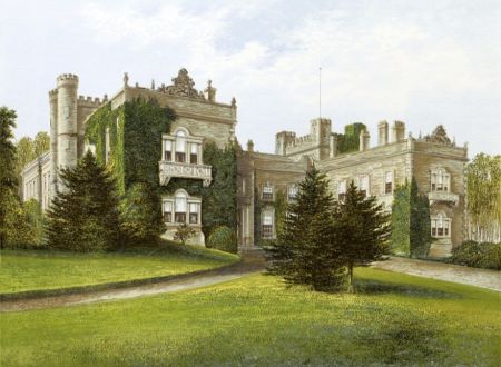
In the later 19th century, there were projects close to the house. The detached stable block was built (Thomas Oliver, architect, listed Grade II). The estate appears on the County Map of William Andrews Nesfield, who may have been involved at Aske.
Although there is no documentary evidence for this, large cedars and ornamental conifers planted around the house itself survive, which are sometimes indicators of his involvement, and Frith’s photographs of the house taken at the end of the 19th century show a parterre on the south-east lawn which is another of Nesfield’s signature features.
Today, the estate operates as a vibrant working community. Rural Solutions converted the stable block into offices, the gardener’s house in the walled garden has become a private residence and the present Earl is keen to keep the estate landscape well cared for. The estate is not open to the public, but parts can be seen from public rights of way.
Elements of the designed landscape
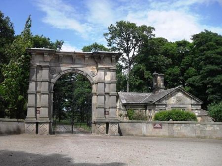
Approaching the estate, the Oliver Duckett eye catcher [1] is visible, which can also be seen from within the estate. On the approach road, the early 19th century formal main entrance gates [2] lead to a drive that passes over a causeway to approach the house. It is a triumphal arch with twin Tuscan pilasters. The wrought-iron gates commemorate Voltigeur, a racehorse owned by Thomas Dundas. This drive is no longer used as a main access route.
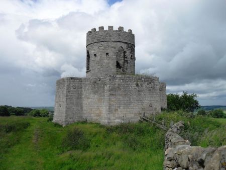
The early-18th-century imaginative proposals of Conyers D’Arcy can still be seen at Aske today. His work provided a foundation which has endured up to date as a basis for the present parkland pattern. Vestiges of the lime avenue on the north east of the house survive, which hint at the once magnificent formal avenues which anchored the house into the wider landscape in the early formal period. The Gothick Temple [3] and the remnants of the pleasure grounds which were its setting can be seen, and the detached pleasure grounds in Low Wood, ornamented with cascades [4].
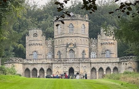

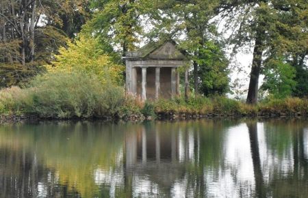
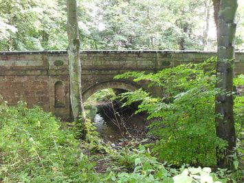
There is the lakeside temple [5] and the form of the park as well as the formal 19th century gardens west of the house. The influence of Capability Brown in naturalising the landscape can be seen. He may have been instrumental in the design of the bridge crossing Aske Beck [6] which carries the main road at the estate edge. Its design with niches might suggest this. Equally, however, it might have been a John Carr project. The house itself is one that can be easily read from its exterior as one with a series of stages in its development.
Photographs in this section courtesy of Ray Blyth, Yorkshire Gardens Trust taken on a 2015 visit. See his Fabulous Follies website for further images.
