Camp Hill park and garden was first developed in the first half of the 18th century by its owner, James Hoyland, who was the head gardener at Castle Howard. It appears that he never lived there and a lack of archive material means that the extent of his involvement is unclear. The designed landscape that we see today probably dates from the early 19th century, when William Serjeantson rebuilt the main house. In addition to ornamental and kitchen gardens around the Hall, there was parkland to the north and south, together with extensive plantations that largely remain intact.
Originally known as ‘Badger Hall’, the first known reference is in 1741 when the death of William Malthouse of Badger Hall was recorded in the parish records. In 1709, the land was owned by Francis Brown when he mortgaged it for 2000 years to John Bendlows (of nearby Howgrave Hall, Sutton Howgrave). On the 25th January 1733, it became legally vested in John Etherington of York in trust for James Hoyland who had purchased the mortgaged site (LULSC YAS MD117/111).
James Hoyland (c1691-?) was the head gardener at Castle Howard. In the Poll Book for the election of 1741, he was listed as living at Castle Howard, with his freehold at Carthorpe, so he may never have lived at the Badger Hall estate. However his widow, Mary, was resident in 1767, when an agreement was drawn up between her and Archilaus Hoyland, son of James’ cousin and heir, Anthony, whereby in return for a payment, she was able to continue living there (LULSC YAS MD117/104). James Hoyland had acquired the core estate of 60 acres from the trustees of the late John Brown (son of Francis?) and added land acquired from Christopher Tanfield (50 acres), William Routh (2 acres) and John Tanfield (10 acres) by 1767. In addition, the estate included the following:
‘All that Messuage or Dwelling House wherein she the said Mary Hoyland now lives with the Plantation on the Northside thereof and the Stable and other the Appurtances thereto belonging and also all that other Messuage or Dwelling House with the Barns Stables and other the Appurtances thereto belonging commonly called Berry Hill House’ (LULSC YAS MD117/104)
Whether James Hoyland was responsible for erecting these buildings and the plantation is not clear. Figure 1 shows the extent of the estate using information from the 1839 tithe map and award that uses historic field names. By 1770, Mary Hoyland had moved out and it was occupied by two tenant farmers: Mr John Barrow (or Barugh) having a ‘Messuage or dwelling house and orchard called Badger Hall’ and William Mitchell ‘one other Messuaqe or Tenement and several closes, 121 acres’ (LULSC YAS MD 117/107).
In 1770, there was an agreement with regard to the estate between John Pickersgill of Ripon and Archilaus Hoyland. It appears to give the former ‘behoof’ or use of the estate subject to a payment but leaving Hoyland as the owner, with an annuity paid to Mary Hoyland until her death (LULSC YAS MD117/111). Mary died in 1779 and Archilaus Hoyland in 1788. The property was sold to the Rev. Josias Lambert sometime before 1789. Before his death on 25 March 1799, Lambert had added a further 10 acres at Burton High Gates. He also changed the name to ‘Camp Hill’ reflecting the Anglo-Saxon entrenchments (Lukis 1870, 175).
It was bought by William Rookes Leeds Serjeantson later in 1799 from Josias Lambert’s estate. It is described as:
‘Mansion house messuage or tenement called Camp Hill, the old Messuage or Dwellinghouse lately occupying its place being commonly called or known by the name Badger Hall with the plantation on the north side thereof situated in the township of Carthorpe. All that other messuage or dwellinghouse commonly called or known by the name of Berry hill house situated in the township of Carthorpe aforesaid’ (SL S153 6/179) [plus closes amounting to 131 acres].
Serjeantson acquired further land in 1807 (SL S163 7/190-191) from Lord Ailesbury and by 1839 the estate totalled 153 acres (NYCRO T MIC 1790/312, NA IR 29/42/74). A further 43 acres was rented in neighbouring Kirlington parish to the south in 1839 (NA IR 29/42/215, NA IR 30/42/215), which later must have been bought, as it is part of the parkland by 1853 (Figure 2). The current Hall was (re?)built c1820 at a cost of £12,000 (NYCRO TD 2 MIC 1048) by Serjeantson and he may be responsible for the two kitchen gardens plus hothouses that are listed in the tithe award, as well as the small parkland surrounding the main building (Figure 3).
Between 1839 and 1853, extensive woodland was laid out to the east and called ‘Hallgarth Moor’, (later Camp Hill Plantation) on land owned by the Earl of Ailesbury in 1839. Kirklington High and Low Wood was in place by 1840 and owned by Hon. Charles Harward Butler Clarke Southwell Wandesforde (1780-1860). It is not clear whether this became part of the estate at a later date.
Colonel William Rookes Leeds Serjeantson died in 1840. His son, George Serjeantson, inherited the estate and died on the 21 Dec 1889, leaving the property to his cousin James Serjeantson (who had predeceased him in 1886) and his heirs. They put it up for sale in 1891 (NYCRO TD 2 MIC 1048) and it was described thus:
Mansion stands on a hill surrounded by a park. The Gardens and Pleasure grounds are tastefully laid out in Lawns, Terraces and Shrubberies.
Woods and Plantations 210a 1r 27p; Mansion, Gardens and Grounds 8a 2r 20p
Residence built c1820, spent £12,000 on erection
2 Kitchen gardens placed near house
It was bought by Captain Francis Horner Reynard in 1896, who also acquired the nearby East Lodge Farm in 1906. Captain Reynard died on the 9 November 1931 and the estate was put up for sale the following September. It was bought in May 1933 by Captain C D Leyland, who then sold it in 1945 to R D Ropner of Stockton-on-Tees:
Sale of the residential estate of Camp Hill to Mr RD Ropner. The estate extends to about 530 acres and comprises the residence of Camp Hill. In the gardens, park and adjoining fields are the remains of a series of entrenchments which give their name to the house and to a large wood nearby. (Yorkshire Post and Leeds Intelligencer, 25 August 1945)
The estate remains with the Ropner family.
Camp Hill park and garden is situated just under 1.5km (1 mile) south of the village of Carthorpe and about 13.5km (8 miles) west of Thirsk. The historic designed landscape covered just under 40 hectares (100 acres) of gardens and parkland (Figure 4), with a further 100 hectares (250 acres) of woodland (Camp Hill Plantation and Kirklington High and Low Woods) to the west (Figure 4). It is bounded on the east by the Carthorpe to Kirklington Road, on the north by the ancient entrenchments and to the west by woodland detailed above. The southern boundary runs from SE 315 821 in the east to SE 311 819 in the west.
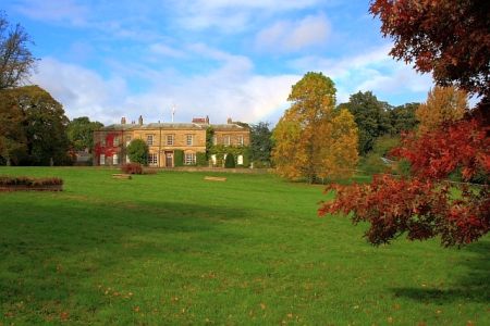
The main building is on a hill at 49m AOD with the surrounding parkland at 40m to 45m OD. The woodland to the west is at 45m to 50m OD. The main entrance is to the south from the Carthorpe-Kirklington Road. Camp Hill House is listed Grade II and described in the Historic England Register of Buildings as a small country house of the early 19th century. There is also an ice house, listed Grade II and described in the HE Register as late 18th century, made of red brick and largely covered in earth. It is circular in plan, with a brick barrel-vaulted entrance passage, which has been extended. Three steps lead to a circular chamber 8ft deep with domed roof.
The gardens around the Hall date from before 1839 and may well have been put in place around 1820 when the main Hall was (re)built (Figure 5). Immediately to the north is a rectangular walled garden, which may have functioned as an additional kitchen garden or orchard. Beyond this is an area of shrubbery and trees. To the north west of the house is a second walled garden that has three straight sides with the north western corner cut off, where there was a well.
To the south of this is an area with glasshouses, of which the one that is freestanding north of the main range possibly the hothouse that is referenced in the tithe award. Here they may have grown grapes, where in 1829, the following was noted: ‘Prize for Black grapes to Mr A Kirkpatrick gardener to Colonel Serjeantson (Black Hambro)’ (Yorkshire Gazette, 26 September 1829). A century later, Captain Reynard was clearly maintaining these gardens as he advertised for: ‘Wanted experienced gardener inside and out, vines, peaches, chrysanthemums, carnations etc under-man kept – Camp Hill’ (Yorkshire Post and Leeds Intelligencer, 20 May 1916).
The parkland to the north and south was created before 1839 and extended before 1853 southwards incorporating the parts that are in Kirklington parish and had previously been rented. This area then reverted to farmland before 1928. There were three ponds shown on the 1839 tithe map to the west of Home Farm and which were extant by 1853 (Figure 6), although only the largest square one remained after 1892.
Books and articles
Lukis, W. G. 1870. ‘On Some Anglo-Saxon Graves On Howe Hill near Carthorpe in the Parish of Burneston, North Riding of Yorkshire’ in The Yorkshire Archaeological and Topographical Journal Volume 1, pp174-181. London: Yorkshire Archaeological Society.
Primary sources
Leeds University Library Special Collection (LULSC)Yorkshire Archaeological & Historical Society Collection (YAS)
- MD 217/104 - Agreement between Archilaus Hoyland and Mary Hoyland of Broadberry Hills, widow of James Hoyland, 3 April 1767
- MD 217/107 - Agreement between Archilaus Hoyland and John Pickersgill, 22 March 1770
- MD 217/111 - Agreement between Archilaus Hoyland and John Pickersgill, 10 April 1770
- IR 29/42/74 - Carthorpe tithe award, 1839 (source: www.thegenealogist.co.uk, accessed 19 January 2017)
- IR 29/42/215 - Kirklington tithe award, 1840 (source: www.thegenealogist.co.uk, accessed 19 January 2017)
- IR 30/42/215 - Kirklington tithe map, 1840 (source: www.thegenealogist.co.uk, accessed 19 January 2017)
- TD 2 [MIC 1048] - Carthorpe: Camp Hill estate sale catalogue, 1891
- T [MIC 1790/312] - Carthorpe tithe map, 1839
Serjeantson deeds
- S153 (6/179) - LEASE for possession, Mrs Dorothy Lambert to William Serjeantson, messuage, Camphill, 12-13 August 1799
- S163 (7/190-191) - Lease and Release between Earl of Ailesbury to William R.L. Serjeantson, land at Carthorpe for £1,205, 2 April 1807
Maps
- Ordnance Survey 1st 6” edition, surveyed 1853, published 1856
- Ordnance Survey Rev 6” edition, surveyed 1908, published 1910
- Ordnance Survey Rev 6” edition, surveyed 1928, published 1930
- Ordnance Survey 25” edition, published 1892
Figure 1 - Land bought by James Hoyland between 1733 and 1767. Map OS 1st ed 6”, surveyed 1853, published 1856. Reproduced by permission from the National Library of Scotland.
Figure 2 - Camp Hill estate in mid 19th century. Map 1st ed 6” OS, surveyed 1853, published 1856. Reproduced by permission from the National Library of Scotland.
Figure 3 1839 Tithe map for Carthorpe showing park and gardens around main house. Carthorpe tithe map 1839 (NYCRO T [MIC 1790/312])
Figure 4 Camp Hill estate in early 20th century. OS Rev 6” edition, surveyed 1908, published 1910. Reproduced by permission from the National Library of Scotland.
Figure 5 Camp Hill gardens and pleasure grounds. Map 1st ed 6” OS, surveyed 1853, published 1856. Reproduced by permission from the National Library of Scotland.
Figure 6 Location of Fish Ponds to west of Home Farm. Map 1st ed 6” OS, surveyed 1853, published 1856. Reproduced by permission from the National Library of Scotland.
")


