A good example of a modest early 19th-century landscaped park with walled kitchen garden and remnants of an early Victorian formal garden, transformed by municipal ownership since the 1930s.
Estate owners
The chief manorial estate at Sewerby was held in 1086 by the count of Mortain. It passed to the Paynel family and then to the archbishops of Canterbury from whom it was held by the Meynells. From the late 12th century the lords of Sewerby under the Meynells were a family that took its name from the village. Robert of Sewerby was lord of the manor of Sewerby in 1316. The family held the manor until 1450 when it passed through the female line until sold to Ralph Raysing in 1565. (Allison, VCH Yorks ER, II, 95)
Raysing in turn sold the manor to John Carliell in 1566. It remained with the Carliell family until 1714 when it was acquired by John Greame I, a Bridlington merchant, who was then tenanting the manor house. The Greame family owned Sewerby for 220 years. (Allison, VCH Yorks ER, II, 95)
The members of the family chiefly responsible for creating the present landscape were:
John Greame III , owner 1798-1841
Yarburgh Greame (Yarburgh Yarburgh from 1852), owner 1841-56
Sewerby Hall and 411 acres were sold by Yarburgh Lloyd Greame to Bridlington Corporation in 1934. With local government reorganisation the house and parkland passed to the Borough of North Wolds (later Borough of East Yorkshire) in 1974, and the East Riding of Yorkshire Unitary Authority in 1996 (Allison, VCH Yorks ER, II, 95).
Early history of the site
There was a park, possibly a small deer park, associated with the manor house at Sewerby in 1377. (Neave, Medieval Parks, 50) The house built or rebuilt by John Carliell soon after 1566, on the site of the present Sewerby Hall, did not stand in extensive grounds. It was surrounded by the houses of the villagers with open arable fields to the north. The ridge and furrow of the open field strips can be seen in the golf course. The main village road ran immediately in front of the south side of the manor house.
The manor house is likely to have stood in the centre of the small village, with the village houses nearby. At some stage possibly in the late 17th century part of the village near the manor house was removed for in 1714 there is reference to ‘tofts or crofts where houses have formerly stood’. (ERALS, Deeds Registry E/ 194/337). They may have been cleared by John Greame I in preparation for building his new house.
Surprisingly there is no evidence that John Greame I (d. 1746) or his son John Greame II (d. 1798) made any attempt to landscape the setting of Sewerby Hall in the 18th century. A pre-enclosure plan of 1802 (HHC, U DDLG/30/897) shows the limited area of land then owned by John Greame III (d. 1841) around Sewerby Hall, about 15.5 acres. Some 6 acres lay adjacent and to the north of the house, and 9.5 acres to the south of the house and the road running from the village eastwards.
The gardens were confined to an enclosed area, nearly 3 roods in size, to the east of the house and a small forecourt between the house and the village street. A rectangular area to the south-west of the house, shown with a pattern of paths and beds, appears to be a kitchen or ornamental garden
Chronological history of the designed landscape
Early–mid 19th century parkland and plantationsIt was not until the enclosure of the open fields to the north of the house between 1802 and 1811 that it was possible for John Greame III to landscape the setting of Sewerby Hall. During this period Greame managed to acquire, by purchase or exchange, all the old enclosures not already in his ownership to the south and east of the hall.
This land together with the two allotments from the open fields, comprising 28 acres to the north of the house, that he was awarded at enclosure gave Greame a large compact landholding of some 180 acres by 1811.
The enclosure award also provided for the closure of the former village road running immediately south of the hall, which was resited to the north (High Sewerby Road), and the closure of the northern section of the Leys road running north to Marton. The road from the east end of Sewerby village going north to Marton was straightened and formed the western boundary of the future parkland.
How much of the laying out of the grounds and planting was carried out by John Greame is uncertain. He extened the hall in 1808 and c. 1830 and built a large stable block in two stages after 1808. Teesdale’s plan, published 1828 but based on Greenwood’s survey of 1817-18, shows a plantation on the west side of the park to the north of High Sewerby road. Bryant’s plan of 1829 shows planting further south.
Two images of the hall from the south c. 1830 show the house overlooking open pasture to the south with a buttressed brick retaining wall or ha-ha. There appears to be another wall to the south of the grazing land. The pasture is undulating suggesting the ridge and furrow of the open fields. There are groups of mature trees to the east and west of the house with smaller trees and bushes to the south east.
By 1840 the plantations covered some 13 acres; these were probably the boundary plantations to the north and west of the parkland as shown on a plan of c. 1845. Further planting was undertaken 1841-45, a total of 26 acres. This planting completed the boundary plantations as shown on the first Ordnance Survey map, surveyed 1851-2.
Mid 19th-century gardensAfter completing the planting around the boundary of the parkland and the area to the east Yarburgh Yarburgh turned his attention to the grounds immediately adjacent the house. A new layout for the drives to the hall was implemented. At the east end of the village street a pair of lodges flanking an entrance arch was built c. 1845 and from there a drive led directly to the hall. A little further north on Church Lane another lodge was built alongside entrance gates that led to a series of drives which, as well as linking with the main drive, gave access to the stables and rear of the hall.
On the west side of the hall a classical archway was built, and on the east side a large greenhouse or conservatory. These were designed by H.F. Lockwood of Hull as were the lodges and the Italianate tower of 1847 on the stables. A formal terrace was created to the south of the hall with a stone wall and balustrade taking the place of the brick ha-ha. Female statues of Ceres and Flora were placed at either end of the balustrade. The recently completed terrace was painted by the Revd O.W. Kilvington in 1850.
In the parkland to the north-east of the house Yarburgh built a large domed octagonal glass conservatory probably designed by H.F. Lockwood. A water-colour of 1847 by Kilvington shows the conservatory in an informal landscape backed by a plantation. To the south west of the conservatory there is depicted a small ornamental garden.
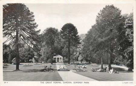
Probably soon after 1850 a formal garden was laid out to the south of the conservatory. It is shown on the 1891 Ordnance Survey map but not on that surveyed 1851-2, published 1854. A straight path leading from a seat at the south end to the conservatory at the north end is crossed at the middle by a straight path at a right-angle leading from a seat in the east to a statue in the middle. Trees, presumably monkey-puzzle, some of which survive, flanked the paths and plantations surrounded the formal garden. A formal terrace with stone wall and central steps fronted the conservatory.
In 1852 Yarburgh Greame inherited the Heslington estate and changed his surname to Yarburgh. The last four years of Yarburgh Yarburgh’s life were spent on the restoration and extension of Heslington Hall and is likely that he paid less attention to Sewerby.
Last Greame owners 1856-1934Map evidence suggests that there were no significant changes to the grounds at Sewerby in the late 19th-early 20th century. The only alterations appear to be in the layout of the walled kitchen garden. The circular planting design shown on the OS plan published in 1854 is replaced by 1890 with a pattern of straight paths dividing the garden into four quarters with a perimeter path. By 1890 there was a central shelter or greenhouse and along the north wall a series of glasshouses.
Surviving garden account books for 1856-62, 1876-89 and 1892-7 indicate the importance of walled and formal gardens at this time. (HHC, U DDLG/43/11, 13) There were six full-time gardeners and plants were acquired from Backhouse & Son of York, nurserymen and seeds from Carters and Suttons.
The octagonal conservatory in the formal garden was demolished and replaced by a smaller Classical summer house in 1923-4 designed by Brierley and Rutherford of York. (HHC, U DDLG/43/45)
Municipal ownership from 1934After Bridlington Borough Council purchased Sewerby Hall and grounds in 1934 a number of changes were made including the removal of the centre of the balustrade to the south of the hall, replaced by steps, and the reduction of the Classical summer house in the formal garden to its present size.
By 1939 a 9-hole golf course had been laid out in the North Park with a putting green nearer the hall and part of the South Park was sacrificed for a bowling green and croquet lawn overlooking the sea. The walled garden was laid out as an Old English Garden with low box hedges and herbaceous plants and rare shrubs. (Bridlington Guide 1939)
Archery butts and outdoor rifle ranges were provided to the west of the hall ‘carefully placed on undulating land amidst trees, so that they do not mar the beauty of the scene’. (Sewerby House and Park, Bridlington(1947), 19) In the fold yard behind the Coach House an aviary was established which developed into a small zoo after the Second World War.
The open wooded area immediately to the east of the St John’s church and the North Lodge became a public car park with the trees steadily reduced and tarmac area increased. By the 1960s there was a cricket ground in the South Park, between the bowling green and the cliff edge, and part of the area south of the drive to the east of the main entrance was fenced off as an animal enclosure.
Despite all these changes much of the layout and character of the early 19th-century parkland and Victorian gardens remain at Sewerby.
Location
Sewerby Hall and Park are situated at the east end of Sewerby village 2 miles from Bridlington Old Town and Bridlington Harbour.
Area
About 50 acres (20.5 ha) still maintained as parkland and gardens and a further 50 acres (20.5 ha) of former parkland now part of the Links Golf Course.
Boundaries
The parkland is bounded on the west by Church Lane and the lane running south from the east end of the village . The edge of the chalk cliffs form the southern boundary. The northern boundary is marked by the grounds of Marton Hall and the eastern boundary by the plantation known as Long Wood and Home Farm.
Landform
The land lies between 30 m and 45 m AOD gently rising south to north. The bedrock is chalk (Flamborough Chalk Formation) with the boulder clay (Devensian Till) as the superficial deposits in the parkland north of hall, and sand and gravel (Devensian Glaciofluvial deposits) on the hall site and lower park to the cliffs.
Setting
The hall, park and gardens are in a superb setting close to the edge of the cliffs overlooking Bridlington Bay to the south, with housing hidden by trees to the west, a golf course to the east and the wooded grounds of Marton Hall to the north. The site lies on the edge of East Riding Landscape Character Areas 19C North Holderness Open Farmland and 13F Flamborough Headland Farmland.
Entrances and approaches
Two entrances to the grounds were created in the mid 19th century. The main entrance from the east end of Sewerby village street was through an arch flanked by lodges to a drive that led directly to the south front of Sewerby Hall.
A second entrance a little further north on Church Street led via a curving drive to the stables. This entrance now provides access to the car park.
Archway and Entrance Lodges, east end of Main Street Listed Grade II*Tall Doric archway with pediment flanked by single storey lodges to left and right. Brick with stone dressings. Built c. 1845 to designs of H.F. Lockwood. The lodges are now holiday cottages.
North Lodge, 16 Church Street Listed Grade IISingle-storey lodge of yellow brick with stone dressings and hipped slate roof. Of c. 1845 by H.F. Lockwood,
Principal Buildings
Sewerby Hall Listed Grade IA manor house built by John Carleill soon after 1566 forms the core of the present house, evident only in the cellars and basement windows of the central block. This three-storey seven-bay central block of painted brick with stone details is the house as rebuilt by John Greame I in 1714. The centre three bays project with pediment over.
In 1808 John Greame III added two-storey bow-fronted wings to the east and west ends of the house and the semi-cicular portico. These additions were designed by Thomas Johnson of Leeds. The wings were raised to the full height of the main house in 1848 and at the same time a large conservatory (Listed Grade II*) was added to the east side and an archway (Listed Grade II*) on the west side, all by H.F. Lockwood of Hull.
Former Stables, Sewerby Hall Listed Grade II*The former stable block north-west of Sewerby Hall, now used as cafe and shops, was built around 1810 to the designs of Thomas Johnson of Leeds. It replaced early 18th-century stables nearer the house, now public conveniences (as Old Laundry, Listed Grade II *).
The Italianate clock tower on the stables designed by H.F. Lockwood was added in 1847 and the bow windows by Bridlington Corporation after 1937.
Gardens And Pleasure Grounds
Since the late 1930s the gardens and parkland have been adapted for recreational use and for the needs of the large number of visitors to the site. Much of the area to the west of the hall has become used for car parking, a children’s play area and accommodation for zoo animals. Areas of the parkland have been taken for a golf course, a putting green and cricket pitch. Despite these uses Sewerby retains formal garden areas and a parkland character.
Formal gardenThe Victorian formal garden north-east of the hall was probably laid out in the 1850s. The garden retains its original layout with a central path flanked by the characteristic monkey puzzle trees. Another path crosses at right-angles about half way. The central path leads to a terrace with a summer house that replaced the original conservatory in 1924. (HHC, U DDLG/43/45)
Kitchen Garden
The walled kitchen garden north-east of the hall was built soon after 1811 and covers about two acres (one ha). It is surrounded by a high brick wall and it is divided into three growing sections with a fourth service and storage area on the north side. It is well maintained as flower gardens with restored glass houses.
Park and plantations
South ParkOnly a section of the former parkland to the south of the house is still parklike in character with grassland and trees in groups or standing alone. The area remains open giving views of the sea from the hall but much of the area is taken up with a bowling green on the east side and a cricket pitch nearer the cliff edge.
North ParkThe North Park from the north side of the hall to the boundary with the grounds of Marton Hall retains much of its Georgian parklike character of grassland, clumps of trees and border plantations. In the northern section to the north of High Sewerby Road the ridge and furrow of the former open fields can be clearly seen. This area is laid out as a golf course.
North-Eastern ParklandThe boundary plantations are much as they were in the mid 19th century but the area is now part of the Bridlington Links Golf and Leisure Estate. The south-west corner of the area, to the north of the walled garden, was laid out for log cabins c. 2005.
Books and articles
K.J. Allison (ed), Victoria County History, Yorkshire, East Riding, II, 1974
Bridlington Guide, 1939
H.L. Gee, Bridlington 1899-1949, 1949
D. Neave, Sewerby Hall: Historical & Architectural Guide, 2008
S. Neave, Medieval Parks of East Yorkshire, 1991
Sewerby Hall Historic Landscape Survey, 1995
Sewerby House and Park, Bridlington, 1947
Primary sources
Hull History Centre, U DDLG (Lloyd Greame Papers)
Sewerby Hall, Watercolours by the Revd O.W. Kilvington
Maps
Hull History CentrePlan of Sewerby pre-enclosure 1802 U DDLG/30/897
Plan of Sewerby post-enclosure 1803 U DDLG/30/898
Plan of lands owned by John Greame c. 1845 U DDLG/30/902
OtherT. Jefferys, Yorkshire, published 1772 & 1775
H. Teesdale, Yorkshire, surveyed 1817-18, published 1828
A. Bryant , East Riding surveyed 1827-8, published 1829
Ordnance Survey maps published 1854 -2012


