Picturesque 18th-century park with mature woodland, ornamental water, church and deserted village site.
Estate owners
An estate at Kilnwick Percy was purchased by Thomas Wood of London in 1563. In 1574 he built a new house there, of which only the datestone survives. In 1627 the estate passed by marriage to the Anderson family of Lea in Lincolnshire. In the early 18th century Edmund Anderson remodeled the house which was further transformed after it was sold to Robert Denison, a West Riding clothier, in 1784. The hall and estate were sold again in 1840 to Arthur Duncombe, son of 1st Baron Feversham of Duncombe Park, who enlarged the house, adding the giant portico. In 1947 the Kilnwick Percy estate was sold to Harry Whitworth whose son Henry demolished a large portion of the house. When the estate was put up for sale again in 1954 much of it was purchased by Lord Hotham of South Dalton, and the hall became the farmhouse for a 320-acre farm. In 1986 the hall and about 42 acres of surrounding parkland and woodland were sold to the Madhyamaka Buddhist Centre. (Neave, ‘Kilnwick Percy Hall’; inf. from Madhyamaka Centre)
Early history of the site
There was a hall at Kilnwick Percy in the 11th century, and a new house was built in 1574. There is, however, no evidence for an early park, and ridge and furrow in the parkland suggests the open fields of the village lay close to the house. Enclosure took place from the late 16th century and depopulation of the village, which stood to the south-east of the hall and church and still had about ten houses in 1672, was more or less complete by the early 18th century. (S. Neave, ‘Kilnwick Percy deserted village’)
Chronological history of the designed landscape
The park at Kilnwick Percy was probably laid out from c. 1720 by Sir Edmund Anderson. Further work may have been undertaken by Robert Denison c. 1790-1800. Arthur Duncombe, who purchased the estate in 1840, extended the park and is said to have laid out the pleasure grounds.
18th century
Sir Edmund Anderson, who inherited the estate in 1702, made Kilnwick Percy his home from c. 1720. He substantially altered the house, obtaining estimates that year for doors and windows from the York architect William Etty who worked at many country house estates including Castle Howard. (Pevsner & Neave, Yorkshire: York & ER, 579)
Nothing is known about the landscaping of the park, but this must have taken place around the same time. Anderson was buying a substantial amount of additional land at Kilnwick Percy c. 1711-12 including 63 acres of pasture called Hungerhills. (ERALS, DDKP/9/12; DDKP/9/13) This must be a reference to the block of land to the west still called ‘Hunger Hill’ which was parkland when the estate was sold in 1840. A painting said to date from c. 1740 shows a distant view of the hall in a well-wooded parkland setting. (Painting reproduced on publicity leaflet for Kilnwick Percy Hall – location of original no longer known) In 1731 Anderson subscribed to Miller’s ‘The Gardener’s Dictionary’ (Neave, ‘Kilnwick Percy Hall’) His second wife (formerly his maid servant) whom he married in 1754 took over management of the estate when his health failed towards the end of his life, and is said to have made new plantations. Sir Edmund died in 1765. (Neave, ‘Kilnwick Percy Hall’)
When the estate was sold to Robert Denison in 1784 it was said that he had cut down timber to help pay for the purchase. (Neave, ‘Kilnwick Percy Hall’) He made further alterations to the hall. A key feature of the 18th-century landscape is the elongated ‘fish pond’ or lake close to the southern boundary of the park. A stream from the lake feeds into a smaller fish pond east of the church, with a third pond in Jenny Firkin Wood, east of the hall. The area north-west of the hall was known as the Wilderness, a name still in use. (ERALS, DDX 759/1; Ordnance Survey plan 2012)
Although documentary evidence about the park is very limited, there is a good description of the estate when it was put up for sale in 1840 which shows that by that date the hall was set in a mature landscape. Beyond ‘the finely wooded park with its extensive and beautiful waters’ there was much ‘woodland scenery, of surprising beauty’, with ‘thousands of forest trees… the hermitage, the fishing ponds, a valley teeming in wild luxuriance, the rippling of the waters and pellucid stream gently gliding through the groves, the American plants fresh and green in little myriads’. Around the estate there was a two-mile ‘terrace drive’. The gardens and pleasure grounds were said to be ‘so beautiful as to harmonize with the landscape’. There was a flower garden adorned by rock work, a fountain, and on the lawn a beech tree 270 feet in circumference, which was estimated to be some 400 years old. The mansion was ‘adorned by a verandah and paved gallery with conservatories very conspicuously placed’. These ‘splendid conservatories’, and the ‘hot and succession houses and pinery’ were ‘formed upon the new principle of hot water’ and produced ‘incomparably fine’ fruit. (ERALS, DDX 759; York Herald 30 May 1840).
At this date the park, excluding the mansion, gardens, lakes and Wilderness, measured just under 100 acres.
19th century
Robert Denison, who had purchased the estate in 1784, probably continued to make improvements until his death in 1829. There is a reference in the 1840 sale particulars, for example, to the adoption of the ‘new principle of hot water’ for growing fruit. Denison must also have been responsible for the ‘cottage ornée’ shown in a sketch of c. 1890. This distinctive picturesque ‘Gothick’ building is typical of c. 1820. It was almost certainly the ‘Old Lodge’ (occupied by the gamekeeper at the time of the 1840 sale) which was still occupied when the census was taken in 1891, some fifty years after a new lodge was built.
Duncombe, who purchased the estate in 1840, extended the park, taking in closes that lay east of the fishpond near the church, and south-east of the larger pond or lake, as far as the Pocklington road, which become the southern boundary. He is also said to have laid out the pleasure grounds (Neave, ‘Kilnwick Percy Hall’) although in the 1840 sale particulars the existing gardens and pleasure grounds were said to be ‘so complete that no auxiliary aid is required’. (ERALS, DDX 759/1) The first edition Ordnance Survey plan, published in 1854, shows a garden area with statue on the south side of the hall, and a fountain, presumably that mentioned in the 1840 sale particulars, to the north-east. There are two summerhouses marked, both overlooking the narrow fish pond in Jenny Firkin Wood, an area also known as the Wilderness. At the north-west tip of the lake in the park there was a boat house.
Soon after purchasing the estate Duncombe built a new lodge on the Pocklington road (see below). The Norman church within the park, all that remained of the village, was rebuilt in 1865. (Pevsner & Neave, Yorkshire: York & ER, 579)
Location
Kilnwick Percy Hall lies 16 miles east of York, and less than 3 miles east of the market town of Pocklington.
Area
The historic parkland was about 343 acres (139 ha) at its greatest extent c. 1910, comprising parkland (264.5 acres), boundary plantations (including Jenny Firkin Wood), 52 acres, gardens and Wilderness 19 acres, and lake and ponds 7.5 acres.
Boundaries
The boundaries of the 18th-century park are shown on the sale plan of 1840 (see above), with the Pocklington road and lake marking the southern boundary. In the mid 19th century the park was extended to the south and east. At this date the western boundary ran north from the lodge on the Pocklington road encompassing the area called Hunger Hill, turned to run east towards the kitchen garden area north of the hall, then continuing in a northern-easterly direction along the edge of Jenny Firkin Wood. To the east the park seems to have extended as far as Warrendale High Farm and the Warter Road plantation, with the Pocklington road marking the whole of the southern boundary.
Landform
The parkland at Kilnwick Percy is situated on the lower slopes of the western scarp of the Wolds. The area of the historic parkland rose steadily from about 50 m AOD in the south west to about 120 m AOD on the Wolds to the north-east. The present area of parkland lies between 45 m and 75 m AOD.
Setting
Kilnwick Percy is in a fine setting looking over the Vale of York from the western slope of the Wolds. The grounds are surrounded by farmland, arable and pasture, with plenty of woodland. To the east is a golf course over part of the former parkland. The landscape of Kilnwick Percy is included in East Riding Landscape Type 10 Complex, Sloping Farmland (Yorkshire Wolds), subsection 10 H facing scarp slope.
Entrances and approaches
In 1840 access to Kilnwick Percy Hall from the Pocklington Road was via a drive that began just east of the building later known as the Old Lodge. (ERALS, DDX 759/1) Around 1845 a new lodge was built a little further west along the Pocklington Road, at the south-east corner of the park, and the course of the drive altered slightly. The new lodge, which still stands (listed Grade II), is in the Greek Revival style, T-shaped with three Ionic porticoes, echoing the massive portico that was added to the hall by Arthur Duncombe around the same time. (Pevsner & Neave, Yorkshire: York & ER, 579-80)
Principal buildings
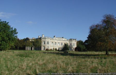
Kilnwick Percy Hall Listed Grade II*
Nothing remains of Thomas Wood’s Elizabethan house, apart from the 1574 datestone, or of Edmund Anderson’s remodelling of the house in the early 18th century. The old house was refronted in late 18th century by Robert Denison and further transformed and greatly enlarged in the 1840s by Arthur Duncombe who added the huge portico to the west front. After the Second World War much of the house was demolished (including the remains of the Elizabethan house) to reduce it to a more manageable size, although this is not obvious from a distance (Pevsner & Neave, Yorkshire: York & ER, 579-80).
Stables
To the north-east of the hall lie the former stables/coach house, two blocks set at right-angles, probably rebuilt in the 1840s when the house was enlarged. The buildings have been converted to bed and breakfast accommodation (The Wolds Retreat) associated with the Madhyamaka Centre.
St Helen’s church (redundant) Listed Grade II
A Norman church, rebuilt in 1864 but retaining some original features, continues to be a focal point in the parkland landscape. (Pevsner & Neave, Yorkshire: York & ER, 579)
Icehouse Listed Grade II
An ice-house, shown on the 1854 OS plan, is located about 290 metres west of Kilnwick Percy Hall.
Gardens and Pleasure Grounds
The extensive gardens and pleasure grounds referred to in the 19th century have not survived. When the Kilnwick Percy estate was put up for sale in 1954, it was noted in the sale catalogue that ‘The actual gardens and grounds, which immediately adjoin the house, have been cut down to quite a small area by including much of the previous pleasure grounds in the Park and are thus very easily and inexpensively maintained. They lie principally to the south, east and west of the house and include lawns, herbaceous borders, rose beds, shrubberies, young specimen trees and gravelled walks.’ (ERALS, DDX 1553/1/16) There are now informal herbaceous borders around the hall and in the walled garden.
Kitchen Garden
In 1840 an area north of the hall and stables, south of the Home Farm was divided into sections described as nursery (3/4 acre), garden nursery (1 acre), garden (1 acre) and orchard (1.5 acres). The sale particulars referred to the hot and succession houses and pinery, ‘formed upon the new principle of hot water’, which produced ‘incomparably fine’ fruit. (ERALS, DDX 7591) The old walled garden survives but is no longer a kitchen garden. It was renovated in 2000 and now has a brick-paved centre circle around two crescent shaped ponds sheltered by yew hedging, with orchards to either side. (Inf. from Madhyamaka Centre)
When the estate was put up for sale in 1954 it was said that between the house and stableyard there was a newly constructed walled-in rose garden and kitchen garden with ample soft fruit. Buildings included a new greenhouse, boiler house and potting shed. (ERALS, DDX 1522/1/16)
Park and plantations
Open Parkland
Kilnwick Percy Hall is still set in an extensive area of open parkland; about 42 acres of park and woodland belong to the present owners, the Madhyamaka Buddhist Centre. A number of trees survive in the open parkland between the hall, church and lake, and to the south of the lake in the area taken into the park in the 1840s. Part of a golf course, in separate ownership, covers the area of parkland west of the lake; some trees remain in this area including the prominent clump towards the centre, shown on the 1854 OS plan. The area north-west of the hall and east of the golf course, where a circular clump of trees marks the position of the ice-house, with a larger group of trees to the west, is under cultivation.
Plantations
The layout of the plantations remains more or less as mapped in the late 19th century. The most prominent of these is the densely planted area around the hall, encompassing to the east Jenny Firkin Wood, with its pond. Designed as pleasure grounds with winding walks leading through the woodland and around the pond, this area was known as the Wilderness in 1840, although on the OS maps this name is usually given only to the area west of the house, where visitors can still follow a woodland walk. The planting here is said to be a mixture of oaks, alder, beech Scots pine and sycamore, with lime trees lining the driveway. Some of the planting is said to date from 1947 (Inf. from Madhyamaka Centre) Another avenue leads from the stable block area to the walled garden.
There are small plantations near and around the fish pond known as Church Pond, and the lake. The large plantation to the south-east, close to the Pocklington Road, was called ‘Flame Bushes’ on the 1893 OS map.
Water
Lake
The ornamental lake south-east of the hall measuring about 5.5 acres, probably created when the park was laid out in the early 18th century, was described as well-stocked with coarse fish when the estate was put up for sale in 1954. The lake was restored in 2011 with help from European funding through LEADER CWWW.
Fish ponds
A spring in Jenny Firkin Wood feeds the small fish pond in the wood, and the more prominent Church Pond in the park, which measures about 1.5 acres. Up to the Second World War the latter was said to be well-stocked with trout.
Books and articles
I. Hall (ed), Samuel Buck’s Yorkshire Sketchbook, 1979
Kilnwick Percy Hall - publicity leaflet produced by Madhyamaka Centre, 2012
D. Neave ‘ Notes on Kilnwick Percy Hall and its owners’, unpublished typescript, 1970
S. Neave’, ‘Kilnwick Percy deserted village site’, unpublished typescript, 1985
N. Pevsner & D. Neave, Buildings of England: Yorkshire, York and the East Riding, 1995
Primary sources
Documents relating to Kilnwick Percy estate (East Riding Archives and Local Studies [ERALS], DDKP)
Sale particulars, Kilnwick Percy estate, 1840 (ERALS, DDX 759/1)
Sale particulars, Kilnwick Percy estate, 1894 (ERALS, DDX 1522/1/16)
Newspapers
York Herald
Maps
1840 plan of Kilnwick Percy estate (ERALS, DDX 759/1)
Ordnance Survey maps published 1854-2012
")

")