The designed landscape associated with Baldersby Park, formerly known as Newby Park, has been shaped by its owners over 200 years to reflect their desire to provide a suitable setting for the main house. Built between 1718 and 1730 for Sir William Robinson, this early Palladian mansion replaced the existing hall that had been set in a walled park with adjacent formal gardens and a wilderness. The nurserymen, London and Wise, provided many of the trees in the park and beyond, as well as plants for the parterre garden and it is possible George London advised Sir William on the design. In the park aligned to the hall, the extant canal and obelisk at its southern extent were put in c. 1704-9.
Thomas Robinson (2nd Lord Grantham) took over the lease of the estate from his father on the latter’s death in 1770, as it was owned by his cousin. Having made plans as early as 1764 with his father to alter what was now an old-fashioned layout, it was only after his marriage in 1780 that Grantham was able to implement them within the confines of the lease. He engaged the landscape designer, Adam Mickle II, that year who remained at Baldersby until 1793 despite the death of Lord Grantham in 1786. The current layout of the main park, together with the southern shelterbelt date from this time.
By 1845, Grantham’s son (later 2nd Earl de Grey) had inherited Newby Hall and Wrest Park, so decided to sell Baldersby to George Hudson, the railway tycoon. While the main changes were to the hall and service buildings, Hudson commissioned Joseph Paxton to redesign the kitchen garden and possibly to alter the gardens in front of the hall. With Hudson’s bankruptcy, the estate was sold to Viscount Downe in 1854 but with his early death in 1857, it became the home of his widow and her second husband. They remodelled the gardens to the west of the hall, added the eastern shelterbelt and reinstated many of the early 18th century avenues.
John Brennard bought it in 1901 and following a major fire at the hall the following year, enlarged the western formal gardens and added at least 12 new glasshouses in the kitchen garden. Following the sale of the estate in 1925 to Skellfield School, most of the former parkland was leased to two farms, the kitchen garden became a commercial market garden and later a caravan park. With the closure of the school in 1970, the two farms bought the leased land leaving 50 acres adjoining the hall, which became the site of the present Queen Mary’s School in 1984. Despite this, the grounds still provide a suitable setting for the hall as the designed landscape around it remains open parkland and gardens.
Estate owners
In 1284-5, John de Newby held 2 carucates (c. 240 acres), which was probably the entirety of Newby (Surtees Society 1867, 184). John’s daughter and heir married John Green (The Harleian Society 1881, 145) and the property remained with the Green family until 1576/7 when it was bought by John Dawnay. He sold it in 1586 to William Robinson whose grandson, William, inherited the property in 1626. After the death of William’s son, Sir Metcalfe, in 1689 Newby passed to his nephew, William.
Sir William Robinson died in 1736 and his second son, Tancred, succeeded after the death of his elder brother, Metcalfe, a week after their father. However Metcalfe had left a will indicating that the estate at Newby should go to his other brother, Thomas. The ensuing legal dispute was resolved with Tancred and then his son, William, having ownership of the estate. In 1762, Sir William leased Newby to his uncle Thomas (later Lord Grantham) for 21 years. Sir William died in 1770 and the estate went to his brother, Norton, who was declared a lunatic on 2 May of that year. Lord Grantham also died in 1770 and the lease of Newby went to his son, Thomas. The lease was then renewed on an annual basis from 1783, as Thomas would inherit it on the death of Sir Norton Robinson.
Lord Grantham died in 1786 and his eldest son, Thomas Philip, became 3rd Lord Grantham. In 1792, he inherited both Newby Hall from his relative, William Weddell, and Newby Park with the death of Sir Norton Robinson. The following year, his mother decided to move to Newby Hall and Newby Park was rented out first to Richard Thompson from 1807 and then John Charles Ramsden from 1814 to 1835.
Thomas Philip Robinson (now Earl de Grey) sold the estate to George Hudson in 1845. After Hudson went bankrupt, William Dawnay (Viscount Downe) bought it in 1854. It was then renamed as Baldersby Park and remained with the Downe family until 1901, when it was put up for sale and acquired by John Brennard. In 1926 the estate was sold to Skellfield School, who remained there until 1970. The hall and 50 acres then returned to private ownership until 1984 when the present Queen Mary’s School took over. The rest of the parkland was sold to the two farms who were leasing the land.
Key owners and tenants responsible for major developments of the designed landscape and dates of their involvement:
Sir William Robinson 1626-58
Sir Metcalfe Robinson c. 1665-89
Sir William Robinson 1st Bt 1689-1736
Thomas Robinson (2nd Lord Grantham) c. 1763-86
Richard John & Elizabeth Thompson 1807-14
John Charles Ramsden 1814-35
George Hudson 1845-54
Mary, Viscountess Downe 1857-1900
John Brennard 1901-25
Early history of the site
The first mention of Newby was in 1284/5 when John de Newby held 2 carucates [c. 240 acres] of land from the Percy family as part of their Topcliffe estate and paid rent of 12d (Surtees Society 1867, 184). Judging by the name, ‘New farm’, it probably consisted just of a farmstead at this time. By the early 14th century, Newby was in the hands of the Green family, possibly through the marriage of the daughter and heir of John de Newby to John Green (The Harleian Society 1881, 145). In 1549, Richard Green died seised of the ‘manor or capital messuage’ of Newby (VCH 1968, 76). His grandson, John, sold the manor of Newby for £800 on 30 Dec 1576 to John Dawnay (EYA CLY/2/2/2). Dawnay then sold it to Alderman William Robinson on 11 Apr 1589 for £1500, together with lands in neighbouring Rainton, Baldersby, Norton le Clay and Aisenby (EYA CLY/2/2/4). Robinson also bought the manor of Rainton with 8 messuages, 6 cottages and land there from William and Grace Tankerd in 1602 (YAS 1890, 184).
When William Robinson bought the Newby estate there was a ‘capital messuage’, although whether he altered this or constructed another building is not clear. A survey in 1613 of Topcliffe manor listed John Allen, miller of Topcliffe, holding ‘three gristemilles on Swale near Newbye House’ (Fisher 1954, 62) but this could be the medieval manor house. William died in 1616 and was succeeded in 1626 by his grandson, William, who moved to Newby before March 1629 when the baptism of his son, Metcalfe, was recorded at the nearby Topcliffe church. The Earl of Northumberland (owner of Topcliffe manor) still had a nominal right to Newby as Robinson paid him 7s on 16 October 1634 (EYA CLY/2/2/29). This ‘knight’s fee’ was for 2 carucates (c. 240a), a toft (homestead) and 3 acres of land in Newby and 3 acres of land in Asenby and represented the later Newby Park estate.
William Robinson was knighted in 1633 and on 25 February 1635, he was given ‘a licence for the enclosure and emparkment of 150 acres of demesne lands at Manor of Newby with liberty of free warren’ by the king (PRO 1864, 523). A park was constructed and stocked with deer as its keeper, Richard Batty, was attacked there on 11 June 1660 by three poachers (Surtees Society 1861, 164). According to the testimony of Batty’s son, he had been walking from his lodge to the ‘castle’ (Newby Hall). A survey of 1691 (EYA CLY/2/2/33) noted 124a of pasture, now divided into fields, to the west of the hall, which may have been part of the former park (Figure 1). The lodge would have been at a strategic location to provide a good view of the surroundings, so one possible site may be on the northern edge near the river, where the later pavilion was built (Figure 1).
Sir William Robinson died in 1658 at the family’s estate in Rawcliffe, near York. His son, Metcalfe, succeeded him but he died without any surviving issue in 1689 and Newby was inherited by his nephew, William. As William told his wife that he had ‘no thoughts of building or anything else that costs money’ on 21 November 1689 (WYASL WYL150/6002/40), the survey from 1691 (EYA CLY/2/2/33) described the Newby estate on his inheritance. The ‘Court gardens orchards & fold yard about the house’ covered 6a 39p. To the east of it, next to the river, was a meadow of just over 14 acres, called ‘Fish Garth’ (ibid) that has the remains of a trap to catch fish. To the southeast of the hall was 50 acres of arable land, mainly comprising of ‘Broad field’ split into three parts and covering 34 acres (ibid). The major change made by Sir Metcalfe was the division of the park into fields of pasture including ‘High field’ of nearly 58 acres and Little Carr of 25½ acres (ibid). This suggested that the deer park had ceased to function sometime after 1660.
Chronological history of the designed landscape
1694-1736
By 1694, Sir William wanted to update the grounds in the latest fashion and was making plans with his son, Metcalfe. Both were visiting other gardens and William had purchased Leonard Meager’s The English Gardener (Furse 2023, 45) for guidance. He started by buying 50 lime trees and seeds from Francis Weston of London, together with gilded lead flower pots, steps and wrought coping (WYASL WYL5013/2277/6/11) for the existing gardens next to the hall. By 1699 though, he had more ambitious plans both for the gardens and the wider landscape. He started by creating formal gardens next to the hall, adding a new park and carrying out significant planting of trees in the former park’s pastures.
The new gardens to the east comprised of a parterre and a ‘wilderness’. The former had clipped evergreens that can be seen in the sketch by Samuel Buck c. 1720 (Hall 1979, 252/3) and in place by September 1700, when London and Wise of the Brompton Nursery of London supplied ‘pyramid’ and ‘standard’ evergreens such as yew, juniper, holly and laurel (WYASL WYL5013/2277/6/14 Bundle C). The previous year Robinson had bought 4 lead statues and 5 lead figures (WYASL WYL5013/2277/6/847), items that were popular additions to the parterre garden. Next to the parterre, a wilderness was planted c. 1702, comprising of formally arranged, clipped trees. It is shown on the 1759 estate map (WYASL WYL5013/D/4/1/1, Figure 2) and in a sketch c. 1760s probably by Thomas Grantham (WYASL WYL5013/D/4/1/13, Figure 3). There was a fountain but its exact location is unknown and perhaps a viewing mound in the northwest corner.
To the south of the hall, a new park was created from 47a of former arable fields that were converted to pasture (EYA CLY/2/2/33). This was made between 1704 and 1707 when the ground was levelled and walled, with the former work costing £200 (WYASL WYL150/6003/8). Inside the park was a patte d’oie (goose foot) arrangement of a semicircular row of trees, two radiating avenues and in the centre a canal that was started in 1704 when wood was bought for its construction (WYASL WYL5013/124-8). Both Sir William and his son were pleased with the changes, with Metcalfe writing to his father from Germany on 3 August 1705: ‘The seats in the country...have nothing that deserve looking upon, except the gardens of some of ‘em, which I can’t reckon neither above the rate of yours at Newby’ (WYASL WYL150/6005). Further radiating avenues of trees were added in the wider landscape and an area of woodland created in the ‘Little Carr’ to the southwest. These features were probably added between 1710 and 1717 when Sir William bought nearly 7,000 forest trees, the majority being oaks (Furse 2023, 52). A letter from Lady Robinson in early 1714 described her husband planting and levelling in the high pasture (WYASL WYL150/6006[13151]). The overall design can be seen in the survey plan of 1767 (WYASL WYL5013/D/4/1/5, Figure 4).
While the design may have been done by Sir William himself, it is possible that he had advice from George London. On the 20 August 1701, London wrote to Thomas Coke: ‘on the 5th of September I shall set out...towards...Yorkshire and shall be out one month...and then return to Sir William Robinson’s by the 20th...You may send your commands to me at the posthouses...or at Sir W. Robinson’s or Sir Edward Blackett’s at Newby’ (Historical Manuscripts Commission 1888, 435). London regularly visited his customers and according to Stephen Switzer, who worked for him, ‘saw and gave directions once or twice a year in most of the noblemen’s and gentleman’s gardens in England...he made his northern circuit in five or six weeks’ (1715, 60). The degree of London’s involvement in the design is uncertain as Switzer (ibid, 61) said his visits comprised just of ‘conversing with gentlemen and forwarding the business of gardening’. Switzer further noted ‘he [London] might not come up to the highest pitch of design always, yet that might be attributed to the haste he was generally in’ (ibid), implying the visits were more about ensuring continued sales of plants rather than focusing on the designs.
Jane Furse (2023, 56) has suggested London had drawn up a plan for Newby given the following bills from 1709: Charles Hall and George Jackson ‘for 2 days going to Newby to draw the gardens to send to London’ on 2 June (WYASL WYL5013/2277/6/14 Bundle C) and William Smith at Brompton Parks ‘please pay Mr Henry Kentish [gardener at Castle Howard] the sum of £17 for your use of Messrs London & Wise’ on 28 July (WYASL WYL5013/2277/6/13). The first bill is ambiguous as ‘London’ may mean the place and he would have been referred to as ‘Mr. London’ or ‘George London esq.’ The second clearly refers to a bill for London and Wise’s services but this may have been the ‘general directions’ that London had offered earlier. From this evidence, it is not possible to say that London drew up a plan at this time.
In 1717, Sir William planned to alter the existing hall but by early 1718, he had decided to construct a new building. To continue to live there, he started by adding a new wing to the old house that can be seen in Buck’s sketch (Hall 1979, 252/3). As it was in the same location, there was little major alteration to the grounds while building work continued until 1730, although the parterre garden may have been altered or removed to accommodate the new building. Gardening fashions though had changed in the 20 years since Robinson started and he may have been influenced by them. Pseudo defensive walls and bastions had been popularised by Switzer in his writings (1718, 115; Figure 5) and his design for Grimsthorpe Castle that was made in 1716 (Jacques 1990, 19). In 1721, the mason John Simpson was paid for the ‘the battlements of the gardening’ (WYASL WYL5013/2277/6/17-21), which may relate to the angular walls on the southeastern section of the park wall (Figure 2).
Robinson also added 2 obelisks as eye-catchers and a pavilion to the designed landscape. These were features that has been recently added to Lord Burlington’s influential garden in Chiswick, which may have inspired him. The date of the obelisk at the southern end of the fishpond is not known but may be as early as 1708, when payment was made in August for ‘pillars’ (Baldersby Park Restoration Plan 2001, 5). The second one in the ‘Pasture’ was erected in 1734 by the mason, Mr. Doe (WYASL WYL5013/124). The pavilion was started in 1729 and completed by 1733 (Furse 2023, 55). No pictures exist of it as it was demolished soon after 1784 but a drawing by Grantham of a proposed gardener’s house notes that it should ‘be chiefly built with materials of the pavilion’, i.e. stone (WYASL WYL5013/D/4/2/8).
1737-1792
With the death of Sir William in late 1736 followed by his son, Metcalfe, a week later, the future of the estate was subject to a family dispute. Under the terms of Sir William’s will Tancred, his second son, was due to inherit as Metcalfe had no heirs. However Metcalfe left a will that named his younger brother, Thomas, as his successor. It was settled out of court with Tancred inheriting the estate but had to pay significant compensation to his brother. Both Sir Tancred and his son, Sir William, who inherited in 1754, lived at Newby but made no major changes to the designed landscape.
In 1762, Sir William leased Newby to his uncle Thomas (now Lord Grantham) for 21 years. There were however restrictions in the lease that included not being allowed to fell any timber (WYASL WYL5013/2789-90). Despite this, Grantham and his son, Thomas, were keen to update what was now an old-fashioned layout. On July 18 1763, Thomas was asked by his father to bring ‘the survey of the lands’ (BA L30/14/333/6) from London to Newby. This was probably the 1759 survey commissioned by Sir William, who now lived in Soho Square, London.
In April-May 1764 there were payments for ‘the sketches of the Grounds the first [and] second time over’ (Furse 2023, 62). These may have been for the ‘Plan for altering the park at Newby, 1764’ (WYASL WYL5013 D/4/1/3, Figure 6) that is signed ‘TR ins: & fec:’ [TR drawn & done] suggesting that it was by Thomas Robinson junior. He was a competent artist and later became an amateur architect, designing many buildings for Newby Park. While Robinson may have been responsible for the design, the fact that payment was made for the sketches indicated someone else’s involvement. A professional designer of the time, such as Lancelot Brown or Richard Woods, may have provided advice but nothing in the archives has been found to confirm this.
A major part of the plan proposed diverting the public road that ran through the estate but the 1767 survey plan (WYASL WYL5013/D/4/1/5, Figure 4) showed that this was not carried out. They were however able to remove the water mill to the west of the hall that belonged to their neighbour, Lord Egremont, as part of the Swale Navigation Scheme in 1768. Any other changes were limited by the restrictions on tree felling, which remained in place with the death of Sir William in 1770. Although the estate went to his brother, Norton, the latter was declared a lunatic on 2 May and trustees were appointed to manage his affairs. Thomas, 1st Lord Grantham, died on 30 September 1770 and his son, Thomas, took over the lease of Newby. Despite being appointed ambassador to Spain, the 2nd Lord Grantham’s interest in developing Newby remained as he was likely to inherit it from his cousin, who had no legitimate children.
Mindful that he could not remove any healthy trees, on the 3 August 1772 Grantham advised his sister that he would be ‘writing to the Aislabies [at Studley Royal] to ask them to look over Newby Park and direct anything, even new planting at side of house if the old trees do not thrive’ (BA L30/17/4/30). His friend, Robert Darley Waddilove, began to make visits to Newby and reported back to Grantham on 12 February 1774 that he had ‘surveyed around the obelisk etc...[and he] looks forward to Grantham’s improvements when he returns’ (BA L30/14/408/8). The following year Waddilove advised on 26 March that he added to the plantations (BA L30/14/408/31) to ‘naturalise’ the design particularly around the house by breaking up the straight lines of trees. On 19 June, Grantham asked his sister when visiting Newby ‘to judge the growth of my clumps & even order them to be thinned near the house if they darken the kitchen too much’ (BA L30/17/4/110).
Grantham returned to England in 1779 and determined to remodel the landscape at Newby within the confines of the lease. Waddilove reported they had a good nursery of young trees and shrubs on 14 September (BA L30/14/408/97) and asked for directions from Grantham on the 4 October (BA L30/14/333/98). He had been in discussions with the ‘Scotch Gardener’ (identity unknown although employed at the time at the Deanery in York) to come and work at Newby, with the latter saying a year of planting should not be lost (ibid).
Waddilove may have thought that additional design expertise was required. On the 24 October, he wrote to Grantham that he would try to learn something of Mr. White (BA L30/14/408/99). This was Thomas White who had worked at Newby Hall in the late 1760s and many other Yorkshire sites but it does not appear that he was consulted. In the meantime Waddilove continued to plant, apparently randomly, to break up the formal lines, telling Grantham: ‘I have no other object than planting – if of no use, there is little lost, they may be considered as nursery trees; if there is any use, there is much gained...I have the vanity to think I could dispose of about a score in the Park, the Pasture & up the river’ (BA L30/14/408/101).
Following the marriage of Grantham to Mary Yorke in August 1780 and their move to Newby, work started in earnest on the remodelling of house and its grounds. On 29 August Lady Grantham wrote that Newby ‘has undoubtedly great capabilities’ (BA L30/11/240/1) but that its current layout had many issues. The bank close to the river ‘is really of very good breadth...at the top of this bank there is a natural terrace which can be made extremely pretty, by making in a few more places breaks to the river & the fields and country beyond’ (ibid). The house ‘stands in a lawn in which are some noble oaks but the phrase of not seeing the woods for the trees was never better exemplified than in the park & in some very pretty grounds beyond, which are also most unnaturally hid from it by a wall & lines of trees’ (ibid). The kitchen garden next to the hall was ‘enclosed with hedges; when they are away & the garden removed (one of the first things I believe will be done) there will I hope be a bit more seen of the water & a good view of the country’ (ibid).
Soon after their arrival, Grantham decided to employ Adam Mickle II to help him with his plans, as Lady Grantham noted in a letter of 21 September: ‘We have also had an improver of ground over, a Mr Miguel (Mickle)...originally a foreman of Mr Brown’s, now settled in this county & recommended by a Mr Thompson (Kirby Hall) as having done well at Ld Scarbrough’s, he is also to send designs and estimates: tho’ his ideas agreed in general with Ld Grantham’s; a gravel walk will certainly be the first object’ (BA L30/9/81/5). Clearly Grantham had strong views on the design and was largely responsible for it with the undated plan (WYASL WYL5013 D/4/1/2, Figure 7) probably in his hand, as it has many similarities to the 1764 plan (WYASL WYL5013 D/4/1/3, Figure 6). Following Grantham’s death in 1786, Mickle recognised his subordinate role, acknowledging that he had ‘made great improvements from his Lordship’s hints’ (BA L30/14/254/3).
Given Lady Grantham’s observations, the first work undertaken by Mickle in late 1780 was to alter the route from the existing entrance to get a better view of the house and to decide on the location of the new kitchen garden. The former involved creating a new carriageway within the park from the southwest corner of the old park wall to the front of the house, cutting through the lime avenue. In a letter on 24 October, Grantham suggested that a proposal had been made to locate the kitchen garden in Lamb’s Close to the west of the house near the river. This does not appear as a proposal on any maps, so probably Mickle’s idea. Grantham had always wanted it in Nooking Close as shown on the improvement plan of 1764 and this is where it was built.
By August 1781, the second new carriageway to the hall from the public road to the southeast had been created with Grantham reporting: ‘this place is handsomer than ever I thought it could be. I can assure you it has improved exceedingly & no sacrifice made for it, except the lime trees avenue, but that opening is so great an improvement that I cannot regret the trees. It is very difficult to say which approach is best, that from Topcliffe is certainly short, but very pleasing indeed; the other answers fully (BA L30/15/54/180).
Plans were also underway on the diversion of the public road south to the edge of the estate, as proposed on the improvement plan (Figure 7), with Grantham noting on 4 August: ‘I have walked around the Little Carr dry shod; the new road will be a very fine one, the border of the wood that way will look shabby for a year or two, not having been outside trees long’ (BA L30/15/54/181). The location for a new entrance was agreed for the western carriageway from the public road, with Mickle being ‘persuaded’ by Grantham to just have one (BA L30/15/54/182). This was halfway between the Rainton and Asenby junctions on the public road. However this was abandoned in favour of the extant entrance next to the kitchen garden by 1785. A new walk was put in from the start of each new carriageway through the parkland passing the head of the canal and adjacent obelisk.
Nearer the house they were ‘beginning to smooth the left hand side of the house where an old kitchen garden stood’ (BA L30/11/240/18) to remove the last parts of the old formal gardens including the wilderness. Two plans of this area show the proposed changes. The first (BA L33/275; Furse 2023, 66 [Figure 39]) was likely to be by Grantham and was concerned with new ancillary buildings in the area. It did though have open pleasure grounds to the east with a greenhouse adjacent and another building to the north of it. To the west a more densely planted area to screen the new buildings was proposed. The second plan (WYASL WYL5013/D/4/1/6, Figure 8) probably was by Mickle and showed the new pleasure grounds within their wider setting. On 2 September 1781, Grantham thought that Newby was ‘exceedingly improved by some openings, two handsome Gravel Roads & one walk nearly round the borders of the Park’ (BA L30/14/315/34), however it ‘is laid for a gradual Improvement as I have neither the means nor the Inclination to all at once’ (ibid).
In late 1780, Grantham had been offered the position of First Lord of Trade with a salary of £1500 a year (BA L30/11/240/5), which provided much needed funds but also meant long periods spent in London. In July 1782, he was promoted to Secretary of State (equivalent to Foreign Secretary) to negotiate a peace treaty with America (BA L30/11/240/23) and progress on both the house and grounds slowed. With the fall of the Prime Minister in April 1783 though, he was out of office and could devote his time again to Newby. His sister-in-law visited in June and said he ‘is delighted with his own improvements and buildings, is overlooking the workmen half the day...at night is frequently scrawling little plans and sketches of architecture’ (BA L30/9/60/287).
In the grounds, the new public road was being completed and the Old Water House (possibly the well in Little Carr that was the in centre of several intersecting avenues) was pulled down in September 1783 (BA L30/14/333/260). A sunk fence around the new pleasure grounds was being constructed with the removal of the old garden walls and the levelling around the ‘knowl’ (knoll) at the end of the garden (BA L30/14/333/259). In April 1784, a roof was made for the new lodge near the Topcliffe entrance known as Cockshutt Gate (BA L30/14/333/272). Although the walls of the kitchen garden had not been built, ‘a very high fir paling around the whole kitchen garden [had been made, with] the north side [having] fruit trees planted against it which the gardener says will transplant whenever the brick walls are built’ (ibid). By June, the new flower garden had been completed with ‘a neat gravel walk in it and a very tolerable beginning of flowering shrubs’ (BA L30/9/81/70).
In January 1785, a second lodge and entrance west of the kitchen garden (‘Ripon Gate’) was being planned (BA L30/15/54/242), which replaced the original idea of an entrance to the east of the kitchen garden. At this time, Mickle was busy planting around Cockshutt Gate (BA L30/15/54/250) and the nearby Cockshot Gate pond was filled in (BA L30/14/333/308). He was also working at the plantation in Little Carr, north of the new public road (BA L30/15/54/262). The main task for Mickle though was to enclose the park that meant completing the sunk fences that led from the new lodges to the hall and starting the one to the south from the kitchen garden to the old entrance. When these were done, together with additional fencing could all the old park walls be removed.
In July 1786 work had to stop with Lord Grantham’s death, as Newby would revert to his cousin, Sir Norton, under the terms of the lease. Frederick Robinson, Grantham’s brother and executor, wrote to Mickle on 28 July and asked him to stop works in progress and detail the current situation (BA L30/14/254/2). The main task was the completion of the southern sunk fence that had to be extended due to the move of the entrance from the east to the west side of the kitchen garden (BA L30/14/254/3). It was agreed that only the part that had been started should be finished and the rest of the proposed length (183 yards) should be just be fenced (BA L30/14/254/4). Despite the lease lapsing, Mickle continued to work at Newby in 1787 and 1788, repairing part of the southern sunk fence near the canal that had collapsed. He also created a new walk in the southern plantation and finished planting the pleasure grounds near the stables (BA L30/14/254/11), all of which were completed by April 1788 (BA L30/14/254/13).
While uncertainty remained with the ownership of Newby Park, in July 1788 Thomas Robinson (3rd Lord Grantham) became the heir to William Weddell of Newby Hall near Ripon. His future was assured financially and in 1792, he inherited this and Newby Park with the deaths of Weddell and Sir Norton Robinson respectively. Having both possession of the estate and the means, this may have prompted the improvement plan by Mickle (WYASL WYL2013/2406 [M 7], Figure 9) the following year. A survey plan (WYASL WYL2013/2406 [M 7], Figure 10) that was probably completed at the same time as it refers to estate ‘before the fall of timber’, gives a view the changes made by the 2nd Lord Grantham and Mickle. The most radical part of the improvement plan was to reduce the canal to a small irregular pond. Elsewhere there would be the removal of trees in the straight avenues and square blocks to make the design more informal. Lady Grantham however did not seem keen to live at Newby Park as ‘it would require much more money to make it suitable to my ideas of comfort’ (BA L30/16/16/56) and proposed renting it out. Mickle’s plan therefore did not appear to have been carried out.
1794-1854
While the Granthams moved to Newby Hall, they continued to visit Newby Park and the young Lord Grantham seemed keen to continue his father’s work. On a visit in 1800, his mother noted that the estate ‘in this season shews also its real beauties & I have with pleasure gone over it with Tom [her son] , who seems very anxious to do it justice in future; tho’ I suspect all his plans will have a much greater tinge of sporting in them than his father ever dreamt of; all this is a sad prospect of expenses’ (BA L30/11/240/102). In 1807 their friends, Mr and Mrs Richard Thompson of neighbouring Kirby Hall, moved into the hall and this may have prompted some changes to the landscape with over 1800 trees from the park, mainly oaks, being put up for sale as timber in late 1808 (Leeds Intelligencer, 19 December). A map from 1812 (NYA ZMI 55, Figure 11) showed trees had been cleared from around the fishpond and in Little Carr, together with reductions in the rest of the parkland.
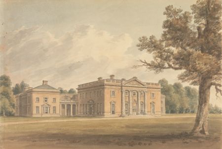
In a letter written on 11 November 1809, Lady Grantham noted that the Thompsons intended to restore the flower garden (BA L30/11/240/236). A painting by Buckler of the hall that year (Figure 12), showed the trees planted over 20 years before were now mature. It was probably at this time the old stableblock to the northwest of the hall was removed and the area planted with trees and shrubs. After the Thompsons moved back to Kirby Hall in 1814, the new tenant was John Charles Ramsden, who made further changes. A small enclosed garden to west of the main front had been added by 1822 (Figure 13) and much of the parkland had been replanted as depicted on a plan drawn between 1815 and 1833 (NYA ZMI 54, Figure 14).
By 1834 there was a new tenant, Henry Ralph Beaumont, but he died four years later. The tithe map of 1839 (NYA T) indicated that the new stables to the north of the hall were being built. The following year, the hall was advertised for rent (Leeds Mercury, 19 September), together with the pleasure grounds, (kitchen) gardens and adjacent orchard totalling 7 acres. In addition to the (newly built?) coach houses and stables, the prospective tenant could also rent forty acres of land next to the hall.
In August 1844, George Hudson acquired the land at Baldersby adjacent to Newby Park from the Duke of Devonshire for £100,000 (Furse 2023, 78). The following October he bought Newby Park from Earl de Grey for £24,600 (ibid). Following his purchase, he extended the hall and built a new stable court and on 17 May 1846, it was reported that ‘the grounds adjacent [to the hall were] greatly improved in appearance’ (The Era). This referred to the two new gardens either side of the front entrance and possibly the alteration of the fishpond to include an island in the southern section (Figure 15). The most radical change was to the kitchen garden that was completely rebuilt in 1847, doubling in size, together with a new gardener’s house (Figure 16). A report in The Gardeners’ Chronicle of 14-28 July 1849 noted that the gardens ‘do much credit to Mr. [Joseph] Paxton, who planned and executed them’.
A new lodge was built at the (Rainton) entrance and another was put at the Cockshutt gate just inside the park, next to the lodge built in 1784. A reservoir, kennels and keeper’s lodge were added to the parkland that now extended along western side of riverbank (Figure 15) but Hudson was running out of funds by 1849 as his railway companies were in financial difficulties. In an effort to pay off his debts, he sold his other properties but kept Newby Park for as long as he could. Finally in 1854, he sold the estate to William Dawnay, 7th Viscount Downe, for £190,000. It comprised of the mansion and land at Newby, Rainton and Battersby of over 2,200 acres. From this point, it became known as Baldersby Park.
Later history
William Dawnay, Lord Downe died in January 1857 and Baldersby Park became the home of his widow, Mary, until her death in 1900. In 1863, she married her second husband, Sidney Leveson Lane, and together they continued to develop Baldersby. By 1890, they had reduced the parkland along western side of riverbank and around the home farm but had added the ‘New Belt’ plantation on eastern side of parkland and divided the island in fishpond into two. There was further ‘infill’ planting to restore the early 18th century avenues as more formal layouts became popular once again. Next to the hall, new gardens and a glasshouse were put in to the west, with a tennis (or croquet?) lawn to east. The now redundant old lodge on road from Topcliffe was removed (Figure 17).
In 1901 Hugh Dawnay, 8th Lord Downe, decided to sell the property and it was acquired by John Brennard, a cotton industrialist, on 11 Jan 1902 for £110,300 (Furse 2023, 95). Two months later a fire broke out during renovations of the hall with the southwest wing gutted, which may have prompted the garden to west of house being simplified and replanted in 1905 (The Gardeners’ Chronicle, 8 August 1908). Apart from a cricket ground and pavilion being added to southern part of parkland, the major change was in the kitchen garden where all the existing glasshouses were renewed and many more added, including one measuring 118 yards long on the northern wall (The Gardeners’ Chronicle, 13 June 1908, Figure 18). Further glasshouses were put on the western wall and to the south of the northern range in 1909.
In December 1925, the Brennards put the whole estate up for sale and it was bought by the Skellfield School. The kitchen garden became a market garden and later a caravan park. The parkland was divided between two farms and leased until 1970 when the closure of the school allowed them to purchase the land. Skellfield School closed in 1970 and the mansion and gardens were privately owned until 1984 when it was acquired by Queen Mary’s School. Much of the former parkland is retained as pasture by the two farms and continue to provide an historic setting for the Grade I listed hall.
LOCATION
Baldersby Park is 4.5 miles (7km) southwest of Thirsk and 5.5 miles (9km) northeast of Ripon.
AREA
The historic designed landscape covered c. 255 acres (103 ha) at its greatest extent in the mid 19th century.
BOUNDARIES
The northern boundary is formed by the River Swale from SE374 767 in the west to SE 389 763 in the west. The eastern boundary follows the line of the parkland south to the site of the former lodge at SE 392 760 on the road from Topcliffe. This public road to Rainton marks the southern boundary to SE 382 758 when it follows the road to Baldersby until SE 375 764. The western boundary is formed by the field boundaries next to Home Farm at SE 377 764 and then to the southern edge of Holme Bank Wood.
LANDFORM
The underlying bedrock is Sherwood Sandstone Group across the northern half of the estate and Mercia Mudstone Group in the southern part. This is overlaid with deposits of clay, silt, sand and gravel giving rise to freely draining slightly acid sandy soils with low fertility. To the east, the soil is a freely draining, slightly acidic loam also with low fertility.
SETTING
Baldersby Park is in the Landscape Characterisation Area of the Vale of Mowbray. This is characterised by the undulating flood plains associated with the rivers Swale, Wiske and Cod Beck. It is framed by the uplands of the Pennines to the west and the North York Moors to the east. It is predominantly agricultural but with many important historic parklands associated with country houses. The hall is at a slightly elevated position at 29m AOD with the land falling away to 23m OD to the north and River Swale, south to the fishpond and east to the park boundary. To the southwest, the ground rises towards Rainton Lodge to 34m OD at northern end of kitchen garden before falling to 32m OD at the southern boundary. To the west, the land rises sharply to 37m AOD at the former reservoir then goes down to c. 32m OD near the obelisk and on towards the former home farm.
ENTRANCES AND APPROACHES
Lodge [Rainton Gate 1]
Located next to the kitchen garden, this was built in 1785 and removed or altered c. 1847 with the remodelling of the kitchen garden.
Lodge [Rainton Gate 2]
At the entrance next to the kitchen garden, this was built c. 1847 and is extant.
Lodge [Cockshutt Gate]
Built in 1784, it was located next to the public road at SE 39222 75990. It was removed in the second half of the 19th century.
Lodge [off Park Road]
This is extant and replaced the 18th century lodge during the period 1845-53.
Entrance
Original entrance created c. 1704-7 when the lower park was created. Located at SE 38902 75736 off the road from Topcliffe to Rainton, it was removed in 1781.
PRINCIPAL BUILDINGS
Baldersby Park House [Grade I – NHLE 1150028]
Built between 1718 and 1730 to designs by Colen Campbell, with alterations in the 1780s by 2nd Lord Grantham and in 1846-7 by George Townsend Andrews for George Hudson. Following a fire in 1902, it was partially remodelled.
Stables
These replaced the original stable block from the late 17th century to the northwest in the late 1830s. A new stable court was added in 1846-7 by George Townsend Andrews for George Hudson.
Pavilion [Grade II – NHLE 1173122]
On west side of house, built (or rebuilt?) between 1902 and 1909.
Icehouses
First shown on the 1st edition 25” OS map surveyed in 1890 (Figure 19), their date of construction is unknown.
GARDENS AND PLEASURE GROUNDS
The survey from 1691 (EYA CLY/2/2/33) listed the ‘Court gardens orchards & fold yard about the house’ covering 6a 39p and this was the area developed by Sir William Robinson from c. 1699. To the east of the old hall and entrance court shown in the Buck sketch of c. 1720 (Hall 1979, 252/3) was the parterre garden. London and Wise supplied the following in September 1700 to plant in it: 14 pyramid yews, 12 pyramid Swedish junipers, 14 pyramid hollies, 12 standard hollies, 16 standard savins (juniper) and 16 standard laurels (WYASL WYL5013/2277/6/14 Bundle C). The year before Robinson had bought 4 lead statues for £24 from Charles Redman and 5 lead figures from Samuel Carpenter of York (WYASL WYL5013/2277/6/847) for it. In 1702, 8 pyramid yews, 2 standard phillyrea, 14 pyramid box, 1 pyramid holly, 1 Swedish juniper, 1 jasmine were supplied by London and Wise (WYASL WYL5013/2277/6/13), as additions to the garden possibly following London’s visit in September 1701.
East of the parterre was the ‘wilderness’ that was planted c. 1702, comprising of formally arranged, clipped trees. It is shown on the 1759 estate map (WYASL WYL5013/D/4/1/1, Figure 2) and in a sketch c. 1760s probably by Thomas Grantham (WYASL WYL5013/D/4/1/13, Figure 3). London and Wise again had supplied the trees including elms and beech in 1702 (WYASL WYL5013/2277/6/14 Bundle C). There was also a fountain as Sir Tancred Robinson noted in 1742 that ‘a leaden pipe [was found] ...running along the garden wall...and suppose it did formerly supply the Fountain in the Wilderness’ (WYASL WYL5013/2241/3) but its exact location is unknown. There may have been a viewing mound in the northwest corner, as a small raised area is still extant and there is a reference to ‘levelling around the knowl [knoll] at end of garden’ on 4 September 1783 (BA L30/14/333/259).
The parterre garden was probably removed during the building of the east wing between 1724 and 1730, as by this time such a design was unfashionable. However the wilderness remained until the major redevelopment of the grounds in the 1780s. This involved removing the old kitchen garden and all the other formal elements of the garden and planting a mix of trees around the stables to the west and shrubs in the eastern ‘flower garden’. By 1822, a small garden enclosed with a stone balustrade had been added to the southwest front. In the late 1840s, this was changed into a sunken parterre garden with a central fountain and a similar one added to the east side, both extant. This may have been to a design by Joseph Paxton, who was responsible for the remodelling of the kitchen garden.
The garden adjacent to the west wing was developed further in the late 19th century by expanding westwards and a glasshouse added to the north (Figure 20). Its present layout dates from c. 1905 following the fire in 1902 (Figure 21) and includes the listed pavilion (see 4.7.3) that may be the building shown slightly further north on the 1890 OS 25” map. A report from 1908 (The Gardeners’ Chronicle, 8 August) described the western sunken garden as having beds with violas and begonias as summer bedding with the centre beds planted with roses.
KITCHEN GARDEN
The first kitchen garden was northeast of the hall next to the river and probably constructed in the 1720s when the present hall was being built. The present kitchen garden was built in 1784 and the walled rectangular section covered 2 acres with an orchard to the south of just over 1 acre (Figure 22). The newly built lodge next to it served as the head gardener’s house. There is no information as to whether there were any greenhouses as none of the maps show any detail of the interior. A report by the head gardener, John Jackson, on the management of bark beds for growing pineapples in 1834 suggested they may have been relying on simpler methods (Transactions of the Horticultural Society of London 1835, 474-5).
The kitchen garden was completely rebuilt in 1847, doubling in size to over 4 acres (Figure 16), together with a new gardener’s house. A report in The Gardeners’ Chronicle of 14-28 July 1849 noted that the gardens
‘do much credit to Mr. [Joseph] Paxton, who planned and executed them. Five acres are walled in with a 14 feet wall well covered with trees bearing good crops. Most of the young peach trees are each producing from 4 to 6 dozen fruit. The garden, though only made about two years and four months, is well cropped. The young gooseberry trees are rendered both useful and ornamental by being trained as standards and summer pruned, and in this way they bear abundantly. Four ranges of glass stand in the centre of the garden, one before the other and in front a half circular wall runs from one end of the range to the other, inclosing a yard from compost. The gardener’s house also stands in front, and commands a view of the whole garden. The pineapples are strong, green and vigorous, and from the appearance of the fruit, which is in great abundance, I am sure Mr. Stuart, the gardener, will cut Providences above 12lbs and Queens above 6lbs weight. They are all growing on the tank system, and are planted out. I have seen nothing equal to them in Yorkshire or Durham. The melons and cucumbers, trained on wire trellis, 5 inches from the glass, are very healthy; many of the leaves measure from 16 to 20 inches across, and there is fruit in abundance. The peach house looks healthy and clean with excellent wood and fruit. The vines, two years planted, are very strong; many of the leaves measuring from 15 to 18 inches across, and I counted from 12 to 14 bunches on each Vine’.
By 1890, while the northern glasshouse had been extended on the western side, there was little change in the layout (Figure 23). With the sale of the estate in 1902, the new owners undertook a major redevelopment with large areas of glasshouses and frames added (Figure 18). A report from The Gardeners’ Chronicle, 8 August 1908 details the grounds:
‘This garden has an area of more than four acres and is divided into eight square portions by paths, and there is a path 6 feet in width all around it, separated from the wall by a border of perennial plants. On the north side of the garden is a continuous range of fruit houses, 118 yards in length. It is divided into six compartments...at the eastern end a partition separates an early and late peach house...opening from the early peach house is a structure built on the other side of the wall and therefore facing north, that is devoted to the culture of cool orchids. A pretty feature is the fern-covered wall...The next division is the conservatory...the wall is covered with tile ‘pockets’ that are planted with varieties of Begonia Rex, Hoya carnosa and ferns...The next division is devoted to pears, with late-fruiting peaches and nectarines against the wall. This opens into a structure devoted to the culture of plums...The last division is 47 yards long and 5 yards wide; many of the trees, including apple, pear, plum and cherry are in pots.
Facing this fine fruit range are the bothies and potting shed...against it [are] lean-to vineries, including early mid-season, and late houses. In front is a row of heated frames...the main block of planthouses...comprises seven modern glasshouses...with the latest improvements...the largest houses are 75 feet in length. The whole block is heated with three ‘Trentham’ boilers...The first house, on the west, is divided into a vinery and two peach houses...The next house is devoted to carnations...The next is a melon house...The next house is divided into two compartments, one being a propagating house; the other containing melons...Number 5 house is a similar structure to the last named, the first compartment being used for the cultivation of Codiaeums (Crotons) and Dracaenas, the other is planted with melons. The next plant house has three divisions; two are filled with orchids, the other with border carnations...The first division of the next house is utilised as a plant stove...the other division was filled with greenhouse flowering plants...
Against the walls surrounding the kitchen garden are planted fruit trees, the top of the wall having a glass coping extending 2 feet; the glass can be removed, if need be, in the summer months...The fruit room has double walls and two roofs’.
Two more glasshouses were added the following year, one adjoining the long northern range and another between the latter and main block (Figure 23). The kitchen garden was sold off in 1925 and became a market garden. In the 1980s it became the present caravan park with the walls, former bothy and adjacent vinery remaining in place.
PARK AND PLANTATIONS
17th century deer park
William Robinson was given a licence to enclose and empark 150 acres of his land at Newby on 25 February 1635. A park was constructed and stocked with deer, probably before 1640. Its keeper, Richard Batty, was attacked there on 11 June 1660 by three poachers (Surtees Society 1861, 164). According to the testimony of Batty’s son, he had been walking from his lodge to the ‘castle’ (Newby Hall). A survey of 1691 (EYA CLY/2/2/33) noted 124a of pasture, now divided into fields, to the west of the hall, which may have been part of the former park (Figure 1). The lodge would have been at a strategic location to provide a good view of the surroundings, so one possible site may be on the northern edge near the river, where the later pavilion was built (Figure 1).
Newby/Baldersby park
The park was created from 47a of former arable fields that had already been converted to pasture (EYA CLY/2/2/33) probably between 1691 and 1700. The ground was levelled and walled between 1704 and 1707, with additions to the walls in 1721. Once completed, it covered just over 67 acres (Figure 2). The old park walls were removed and the larger park was now enclosed with sunk fences to the east and west from 1781, being completed by c. 1788. At this point the enclosed park was 100½ acres, however the large area to the west of 85½ acres was described as ‘Park Pasture’ (Figure 11). By 1853, the parkland had extended further west towards Home Farm and now covered just over 210 acres (Figure 15). This had reduced to 161 acres by the start of the 20th century and now covers the original late 18th century area within the former sunk fences.
Black Wood
Originally planted in the 1710s, it was modified following the improvements in the 1780s that moved the public road south. Measuring 22 acres, it was removed in the late 1920s following the break up of the estate.
The Belt/New Belt
‘The Belt’ around the southern edge of the parkland from the two entrance lodges, was planted in the 1780s. It is still extant and is just under 6 acres. The ‘New Belt’ was added in the second half of the 19th century from the eastern lodge to the east of the hall. It is also extant and is just under 5½ acres.
WATER
The canal or fishpond to the south of the hall was built c. 1704 as part of the formal redesign. It was slightly irregularised in the late 1840s when a small island was put in the lower section, altering the straight western edge. This was further modified in the late 19th century to create two islands.
Books and articles
Fisher, E. J. 1954. Some Yorkshire estates of the Percies, 1450-1650 Vol 2. PhD thesis, University of Leeds.
Furse, J. et al. 2023. Baldersby Park: The History of a House. Baldersby, Queen Mary’s School.
Hall, I. 1979. Samuel Buck’s Yorkshire Sketchbook. Wakefield, Wakefield Historical Publications.
Historical Manuscripts Commission 1888. The manuscripts of the Earl Cowper, K. G., Vol II. London, HMSO.
Jacques, D. 1990. Georgian Gardens: The Reign of Nature. London, B. T. Batsford.
PRO 1864. Calendar State Papers Domestic Charles I 1634-5. London, HMSO.
Surtees Society 1861. Depositions from the castle of York, relating to offenses committed in the northern counties in the seventeenth century. Durham, Surtees Society.
Surtees Society 1867. The survey of the county of York, taken by John de Kirkby. Durham, Surtees Society.
Switzer, S. 1715. The nobleman, gentleman, and gardener's recreation. London, B. Barker and D. King.
Switzer, S. 1718. Ichnographia Rustica Vol II. London, London, B. Barker and D. King.
The Harleian Society 1881. The Visitation of Yorkshire in the years 1563 and 1564 made by William Flower. London, The Harleian Society.
VCH 1968. The Victoria history of the county of York, North Riding Volume 2. London, University of London Institute of Historical Research.
YAS 1890. YAS Record Series Vol. 8: Feet of fines of the Tudor period, pt iv 1594-1603. Leeds, Yorkshire Archaeological Society.
Primary sources
Bedfordshire Archives (BA)
L30/9/60/287 Letter Amabel Yorke to Jemima Yorke, 1783
L30/9/81/5 Letter Lady Grantham to Jemima Yorke, 21 September 1780
L30/11/240/1 Letter Lady Grantham to Amabel Yorke, 29 August 1780
L30/11/240/5 Letter Lady Grantham to Amabel Yorke, 20 October 1780
L30/11/240/18 Letter Lady Grantham to Amabel Yorke, 10 August 1781
L30/11/240/23 Letter Lady Grantham to Amabel Yorke, 17 July 1782
L30/11/240/102 Letter Lady Grantham to Amabel Yorke, 8 August 1800
L30/11/240/236 Letter Lady Grantham to Amabel Yorke, 11 November 1809
L30/14/254/2 Letter Frederick Robinson to Adam Mickle, 28 July 1786
L30/14/254/3 Letter Adam Mickle to Frederick Robinson, 4 August 1786
L30/14/254/4 Letter Frederick Robinson to Adam Mickle, 9 August 1786
L30/14/254/11 Letter Adam Mickle to Frederick Robinson, 10 February 1788
L30/14/254/13 Letter Adam Mickle to Frederick Robinson, 7 April 1788
L30/14/315/34 Letter Lord Grantham to Beilby Porteus, 2 September 1781
L30/14/333/6 Letter from Frederick Robinson to Lord Grantham, 18 July 1763
L30/14/333/98 Letter from Frederick Robinson to Lord Grantham, May 1778
L30/14/333/265 Letter Frederick Robinson to Lord Grantham, 19 September 1783
L30/14/333/308 Letter Frederick Robinson to Lord Grantham, 24 January 1785
L30/14/408/8 Letter Robert Darley Waddilove to Lord Grantham, 12 February 1774
L30/14/408/31 Letter Robert Darley Waddilove to Lord Grantham, 26 March 1775
L30/14/408/97 Letter Robert Darley Waddilove to Lord Grantham, 14 September 1779
L30/14/408/99 Letter Robert Darley Waddilove to Lord Grantham, 24-5 October 1779
L30/14/408/101 Letter Robert Darley Waddilove to Lord Grantham, 11 November 1779
L30/15/54/180 Letter Lord Grantham to Frederick Robinson, 3 August 1781
L30/15/54/181 Letter Lord Grantham to Frederick Robinson, 4 August 1781
L30/15/54/182 Letter Lord Grantham to Frederick Robinson, 6 August 1781
L30/15/54/189 Letter Lord Grantham to Frederick Robinson, 30 June 1782
L30/15/54/219 Letter Lord Grantham to Frederick Robinson, 14 June 1784
L30/15/54/242 Letter Lord Grantham to Frederick Robinson, 10 January 1785
L30/15/54/250 Letter Lord Grantham to Frederick Robinson, 18 January 1785
L30/15/54/262 Letter Lord Grantham to Frederick Robinson, 28 January 1785
L30/16/16/56 Letter Lady Grantham to Katherine Robinson, 2 August 1793
L30/17/4/30 Letter Lord Grantham to Anne Robinson, 3 August 1772
L30/17/4/110 Letter Lord Grantham to Anne Robinson, 19 June 1775
L33/275 Plan of hall and part of grounds, c. 1780
Explore York Archives (EYA)
CLY/2/2/2 Foeffment enrolled in Chancery, John Green to John Dawnay, the manor of Newby for £800, 30 December 1576
CLY/2/2/4 Foeffment enrolled in Chancery, Sir John Dawnay to Ald. Wm Robinson, the manor of Newby for £1500, 11 April 1586
CLY/2/2/29 Receipt for a Feudal Aid paid by Sir William Robinson to Lord Percy, 16 Oct 1634
CLY/2/2/33 Acreages of meadow, pasture, arable land and gardens in Newby, April 1691
North Yorkshire Archives (NYA)
T Rainton with Newby tithe map, 1839
ZMI 54 Rainton with Newby, plans of township nd (early 19th century)
ZMI 55 Rainton with Newby, plan of township 1812
West Yorkshire Archive Service Leeds (WYASL)
WYL150/6002/40 Letter Sir William Robinson to Lady Mary Robinson, 1688
WYL150/6003/8 Letter Sir William Robinson to Metcalfe Robinson, 15 April [c. 1725]
WYL150/6005 Letter Metcalfe Robinson to his parents, 3 August 1705
WYL150/6006[13151] Letter Lady Mary Robinson to son, 1714
WYL5013/124-8 Accounts 1704-34
WYL5013/2277/6/11 Vouchers, 1693-1708
WYL5013/2277/6/13 Vouchers, 1709
WYL5013/2277/6/14 Bundle C Vouchers, 1699-1703
WYL5013/2277/6/17-21 Bills and accounts, 1726-7
WYL5013/2277/6/847 Vouchers, 1699
WYL5013/2241/3 Correspondence, 1742
WYL5013/2406 [M7] Survey & improvement plan by Mickle, nd & 1793
WYL5013/2789-90 Inventories & terms of lease of Newby Park, June-August 1762
WYL5013/D/4/1/1 Survey plan of Newby Park, 1759
WYL5013/D/4/1/2 Plan of Newby Park with suggested alterations of paths, c1762
WYL5013/D/4/1/3 Plan for altering Newby Park, 1764
WYL5013/D/4/1/5 Survey plan of Newby Park, 1767
WYL5013/D/4/1/6 Plan of House and Part of Park, Newby Park, nd
WYL5013/D/4/1/13 Drawing of a formal garden, nd
WYL5013/D/4/2/8 Back front of Gardener’s House, 1784
Maps
Ordnance Survey 1st edition 6”, surveyed 1853, published 1856
Ordnance Survey 1st edition 25”, surveyed 1890, published 1892
Ordnance Survey revised edition 25”, surveyed 1909, published 1911
Figure 1 – possible boundaries of mid 17th century deer park with site of lodge on Ordnance Survey 1st edition 6” map, published 1856. National Library of Scotland CC-BY.
Figure 2 – Estate map of Newby Park, 1759. West Yorkshire Archive Service Leeds WYL5013/D/4/1/1.
Figure 3 – Drawing of wilderness, probably by Thomas Robinson probably 1760s. West Yorkshire Archive Service Leeds WYL5013/D/4/1/13.
Figure 4 – Estate map of Newby Park, 1767. West Yorkshire Archive Service Leeds WYL5013/D/4/1/5.
Figure 5 – Design for a ‘Rural Garden’ from Switzer, S. 1718. Ichnographia Rustica Vol II. London, London, B. Barker and D. King, 115. Public domain
Figure 6 – Proposal for improving the park of Newby, 1764. West Yorkshire Archive Service Leeds WYL5013/D/4/1/3. Note north is to the bottom.
Figure 7 – Plan for altering Newby Park, nd (c. 1762). West Yorkshire Archive Service Leeds WYL5013/D/4/1/2.
Figure 8 – Proposal for landscaping around hall c. 1780 possibly by Adam Mickle. West Yorkshire Archive Service Leeds WYL5013/D/4/1/6
Figure 9 – Improvement plan by Adam Mickle for Newby by Adam Mickle, 1793. West Yorkshire Archive Service Leeds WYL5013/2406 [M7].
Figure 10 – Survey map of Newby c. 1792. West Yorkshire Archive Service Leeds WYL5013/2406 [M7].
Figure 11 – Map of the township of Rainton with Newby, 1812. North Yorkshire Archives ZMI 55
Figure 12 – Newby Park by John Buckler, 1809. Yale Center for British Art, Paul Mellon Collection B1986.29.332. Public domain
Figure 13 – Drawing of Newby Hall from Neale, J. P. 1822. Views of the seats of noblemen and gentlemen, in England, Wales, Scotland, and Ireland. London, Sherwood, Neely and Jones. Public domain.
Figure 14 – Rainton with Newby, plans of township nd (early 19th century). North Yorkshire Archives (ZMI 54).
Figure 15 – Baldersby Park estate from Ordnance Survey 1st edition 6” map, surveyed 1853, published 1856. National Library of Scotland CC-BY
Figure 16 – Baldersby Park kitchen garden from Ordnance Survey 1st edition 6” map, surveyed 1853, published 1856. National Library of Scotland CC-BY.
Figure 17 - Baldersby Park estate from Ordnance Survey 1st edition 25” map, surveyed 1890, published 1892. National Library of Scotland CC-BY.
Figure 18 - Baldersby Park kitchen from Ordnance Survey revised edition 25” map, surveyed 1909, published 1911. National Library of Scotland CC-BY
Figure 19 – Location of twin icehouses west of the hall from Ordnance Survey 1st edition 25” map, surveyed 1890, published 1892. National Library of Scotland CC-BY.
Figure 20 - Baldersby Park gardens and pleasure grounds from Ordnance Survey 1st edition 25” map, surveyed 1890, published 1892. National Library of Scotland CC-BY.
Figure 21 - Baldersby Park gardens and pleasure grounds from Ordnance Survey revised edition 25” map, surveyed 1909, published 1911. National Library of Scotland CC-BY
Figure 22 – Newby Park kitchen garden, 1793. West Yorkshire Archive Service Leeds WYL5013/2406 [M7].
Figure 23 - Baldersby Park kitchen garden from Ordnance Survey 1st edition 25” map, surveyed 1890, published 1892. National Library of Scotland CC-BY.


. West Yorkshire Archive Service Leeds WYL5013/D/4/1/2.")


. North Yorkshire Archives (ZMI 54).")


