Everingham Park is of particular historical significance as it retains landscape features of the medieval deer park and three periods of landscape design in the 18th and early 19th centuries. The celebrated gardener Thomas Knowlton from nearby Londesborough was the main adviser for the work carried out in the 1730s-40s. There is no information on who was responsible for the landscaping in the 1760s and later 18th century. The little-known J.N. Sleed of Kensington was employed for the improvements in the 1820s.
Estate owners
The manor of Everingham was in the hands of the archbishops of York before and after 1086. The Everingham family held the manor from the archbishops by the late 11th century until the late 14th century. It then it passed through various heiresses until Sir Marmaduke Constable married Barbara, heiress of John Sothill, in the early 16th century.
The Constable family and their descendants owned the Everingham estate until it was sold, for the first time, in 1982.
The owners chiefly responsible for the landscaping were:
- Sir Marmaduke Constable, owner 1706-46
- William Haggerston-Constable, owner 1746-1797
- William Constable Maxwell, Lord Herries, owner 1819-75
Early history of the site
The Everingham family had a deer park at Everingham in the 13th century. It probably continued throughout the Middle Ages for a park is shown at Everingham on Saxton’s map of the East Riding published in 1577. In 1635 the park covered 378 acres 2 roods and 20 perches (HHC U DDEV 59/7). It was described as having existed ‘time out of mind’ in 1687 when Sir Philip Constable applied for a licence to allow him and his heirs ‘to keep up the said park and store it with deer’. There were over 50 deer in the park in 1702 (Neave 1991, 36). The probable boundary of the medieval deer park, with its characteristic ‘oval’ shape, can be traced in the landscape today.
In 1702 Sir Philip Constable directed his steward at Everingham, Francis Stansfield, to plant 1,000 young oak and elm trees, presumably in the park, and a ‘sufficient number of fruit trees near the walls of the garden’ (HHC U DDEV/9/104). The walled garden was probably a kitchen garden which stood close to the hall and is mentioned in 1743. The kitchen garden may have been accessed through one of the doorways shown c. 1720 on the north and south sides of the forecourt on the entrance or west front of the hall. Samuel Buck’s unfinished sketch of this date appears to show a broad tree-lined avenue leading westwards from the forecourt to grand entrance gates (Hall 1979, 26).
Chronological history of the designed landscape
The park at Everingham was landscaped in three main stages over the century from 1730.
1730s-1740s
The work on the grounds in the 1730s-40s was carried out for Sir Marmaduke Constable (1682-1746) although during this time he was in self-imposed exile on the Continent, seeking relief from the effects of a hunting accident and avoiding persecution as a Roman Catholic. Letters written to and from Dom John Bede Potts, Constable’s estate steward and chaplain at Everingham, chart the great activity in the planting and landscaping of the parkland and gardens (Henrey 1986, 275-290 and Roebuck 1976).
Constable and Potts were fortunate in obtaining the advice and practical assistance of Thomas Knowlton (1691-1781) who was the celebrated gardener to Richard, 3rd Earl of Burlington on the adjoining estate at Londesborough. A study of Knowlton records that he:
was undoubtedly one of the most outstanding gardeners of his time. His advice was constantly sought as a horticulturist, garden designer, and planter, especially in Yorkshire, and his skill in the cultivation of rare and exotic plants was widely recognised. Furthermore he was noted for his interest in our native flora, and was responsible for several first records of plants in the British Isles. (Henrey 1986, 15)
As well as carrying out the transformation of the park at Londesborough to the designs of Lord Burlington and his protégé William Kent, pioneer of the natural landscape garden, Knowlton advised on the gardens and landscaping at Birdsall, Burton Constable and South Dalton in the East Riding and Aldby Park and Duncombe Park in the North Riding.
Knowlton was working at Everingham by November 1730. Initially he was accompanied by Marmaduke Lawson of Moreby Hall, Stillingfleet, an authority on arboriculture. Constable directed operations from the continent passing instructions through his steward who was periodically asked to reward Knowlton handsomely. In early 1742 Constable confessed ‘I have no idea left of Everingham so lett him (Knowlton) do everything as he judges best’ (Henrey 1986, 288).
Extensive planting took place with Lawson and Knowlton supplying a large number of trees including large oaks, 400 limes, 3400 fir seedlings and 1500 beech seedlings for hedges and hornbeam. Amongst the other trees planted in the park were birch, elder, elm, poplar and sycamore and in the gardens there were apricot, peach, nectarine, morel cherry, pear and plum trees. On one occasion Constable sent a consignment of fruit trees to Everingham from a Carthusian monastery at Paris.
The correspondence, a survey and map of 1765 provide evidence to the changes made to the grounds by Knowlton.
- Plantations were made in the park south of the hall. Pecker plantation on left was being planted with ‘Scotch furs’ in 1740.
- Southwards from the hall a walk was laid out through a new plantation to the Harswell Road, and then continued through lines of trees to the beck in Everingham Carrs. The line of the first part of this survives as the South Avenue.
- An avenue, planted with elms from a nursery at Scorborough, was laid out running west from the hall.
- A ‘line of elms’ was planted from the churchyard to the ‘back way’ to the hall.
- The Hall Garth was levelled and planted with fruit and other trees.
- To the north of the hall two rectangular ponds were created one of which was stocked with carp and perch from Londesborough.
- A green walk was laid out on each side of the ponds.
- A ditch, possibly a ha-ha, was dug the length of the front of the hall.
Mid-18th century
William Haggerston-Constable (d. 1797) succeeded to the Everingham estate on the death of his great uncle, Sir Marmaduke Constable, in 1746. In the years 1757 to 1764 he rebuilt Everingham Hall to the designs of John Carr and then seemingly set about improving the park and gardens. There are no plans or detailed documentation recording what was done at this time but clues are provided in the estate accounts and correspondence. A scheme for bringing water to the hall and pond was put forward in 1764 by Mr Foord and the following year work on a sunken fence and the new kitchen garden are mentioned (HHC U DDEV /9/113; 59/34; 60/20A).
The kitchen garden covering 3 acres was recorded in the 1765 survey and shown on the 1765 plan some distance to the east of the hall. The large irregular pond shown in the centre of the Lawn on the plan but not recorded in the 1765 survey must have been created soon after because it appears on Jefferys’ map of c.1771.
Later 18th century
A comparison of the first large-scale plan of the park at Everingham made in 1806 with the estate plan of 1765 and Jefferys’ map show that it was transformed at some stage in the later 18th century to produce a more natural landscape in the style of Lancelot 'Capability' Brown. A serpentine lake was created to the north of the Hall, clumps of trees were planted in the park and it was bounded by plantations on all but the west side. The formal South and West Avenues were removed and the walled kitchen garden was taken out of the park and resited between the lake and the village street. The large irregular pond was filled in.
No information has been found to date this significant period of landscaping. It might have been carried out later in the 1770s. There was a complaint from the estate steward of the great expense of the work on the gardens in 1776 which he thought was ‘very ill conducted’. Two years later the work of a Mr James Bayne, in planting and thinning the shrubberies, was said ‘to go on well’ (HHCU DDEV/60/20A).
No designer is known for the work at this time but it has the hallmarks of Thomas White, who worked for Brown between 1759-65, and later became the most prolific landscape gardener in the north of England and Scotland. It is significant that the nearby landscapes at Houghton Hall, Sancton and Holme Hall, Holme on Spalding Moor were designed by White in 1768 and 1778 respectively. The owners of these estates, Philip Langdale and Lord Langdale, as fellow Catholic landlords would have been close associates of William Haggerston-Constable of Everingham. The serpentine lake at Everingham is similar to that shown on Thomas White’s plan for Houghton Hall (Neave & Turnbull 1992, 36-39).
1820s
The final major phase of activity at Everingham, which completed the landscape that largely survives today, is the best documented. William Constable-Maxwell (1804-76) inherited the Everingham estate in 1819 and on coming of age in 1825 he commenced a series of ‘improvements’ which included alterations to the grounds, considerable rebuilding in the village, the building of the magnificent Roman Catholic chapel 1836-39 and major extensions to the Hall 1845-48.
The grounds were improved 1826-7 at a cost of £1294 under the supervision of a little-known landscape gardener, J.N. Sleed of Kensington (HHC U DDEV/9/48, 139, 213-215). Sleed had been the gardener at Brocklesby Park, Lincolnshire in 1813. Sleed, an enthusiastic follower of the horticultural writer J.C. Loudon, was working at South Dalton, 10 miles north-east of Everingham, in the 1820s. There he laid out the kitchen gardens in 1822 and landscaped the grounds to the east of the Hall c.1827 (HHC U DDHO/8/3).
Sleed began work at Everingham in 1826, Constable-Maxwell noting in his memorandum book on 1 April that year:
Sleed came down to give his plans respecting any alteration he might deem fit in the Pleasure Gardens, Park, etc. (HHC U DDEV/9/48)
His main proposals were:
- The removal of ‘the present road beyond the Drawing Room windows’ some fifty yards to the west into ‘the meadow so as to conceal it when looking from the house.’
- The extension of the ‘Pleasure Ground’ on the west side up to the new road.
- The enlargement, and extension to the east, of the lake.
- A new entrance road to the Hall and park from the Thorpe road from the north east. It was to cross the lake by an iron bridge.
A contract was drawn up and work began before the end of April. In October Constable-Maxwell noted that he was ‘much pleased with the improvements’. By then the extension of the lake had been completed but was not yet full owing to the lack of rain. A boat house, almost certainly the one that survives, had been built and the ‘new road’, possibly that through the park, was ready for laying the gravel.
The following April two cast iron bridges ‘executed by Mr Marsden of Wakefield’ for the new approach road and an iron fence for the new pleasure-grounds were erected and on 3 May 1827 Constable-Maxwell recorded that he had ‘opened the new village road and laid the foundation of the lodge’.
Later changes
There were only minor changes to the park and gardens between the 1820s and the early 1850s when the first Ordnance Survey map was surveyed. There was an increase in the number of trees particularly in the west and south-west areas of the park and a road had been laid out across the park from the hall to the Harswell road where a lodge was built in 1841.
The pleasure gardens to the south of the walled kitchen garden appear to have been laid out in two stages. A straight path or avenue led though the centre of the gardens, from the lake to the kitchen garden, and the right-hand section of the gardens had been laid out with paths by 1845 (HHC U DDEV/70/26).
The left-hand section of the pleasure gardens was probably laid out with a wide path going south-north with an open area in the centre by 1867. At this date a small classical oratory was built at the western end of a smaller path running at right angles. By the 1890s there was a rose garden with four Wellingtonias in the pleasure gardens and a lime avenue with perennial borders led to the kitchen garden (Wickham 2006, 11 and Appendix 1).
The grounds were evidently neglected during World War II when the house was taken over by the military. More care was taken of the gardens by the 1950s when the house was used as a country club. The kitchen garden was cleared in the 1970s and all but the east wall was demolished in the 1980s (ibid, 11-12). Later changes to the park were largely confined to planting and re-planting. There was a large plantation cut though by a series of radiating paths in the south-east corner of the park by the 1970s. The eastern section of the lake had been drained by the 1970s.
Despite these changes and the thinning out of the trees within the park the overall pattern of the landscape at Everingham in the early 21st century is much as it was in the Regency period.
Location
Everingham Park lies in the Vale of York, 4.5 miles south of Pocklington, 3.5 miles west of Market Weighton and 13.5 miles south-east of York.
Area
The area of the historic parkland and adjoining plantations is about 160 hectares (395 acres).
Boundaries
The boundaries of the historic parkland are much as they were in the 18th and 19th centuries, although the area of open parkland has been much reduced by 20th century plantations, particularly to the south-east. The area of the historic parkland is bounded on the east side by a curving narrow plantation (Belt Plantation), with more substantial plantations to the south-east (Larch Plantation) and north-east (Pheasantpool, Clayflat and Butcherclose Plantations). To the south it is bounded by Southfield Lane, to the west* by the road leading south from Everingham village, and to the north by village houses and a brick wall along the road to Thorpe-le-Street.
* There is a small area of parkland to the west of the road with Keeper’s House on the west side and the grounds of Ellerker House to the south.
Landform
A flat landscape around 10 m AOD. The soil is of a light sandy nature with some clay on the east side. Geologically the bedrock is Mercian Mudstone (red mudstones, siltstones and sandstones), the superficial deposits are chiefly sand (Bielby Sand Member), with a narrow band of alluvium along the northern edge and Hemingbrough Glaciolacustrine Formation (clays, silts and sands) to the east of the open parkland.
Setting
Everingham Park lies in East Riding Landscape Character Type 1: Flat Open Farmland. The parkland stands out by the extent of tree and woodland cover in comparison to the surrounding flat open farmland which is characterized by medium sized regular shaped fields that are occasionally cut through, or bounded, by small natural or manmade watercourses. The park and adjoining plantations are surrounded by intensively farmed arable land with occasional grass fields.
Entrances and approaches
In the mid 19th century there were three entrances with approaches through the grounds to Everingham Hall. The main entrance, as now, was from just south of the village church where North Lodge was built in 1827. A new road through the park was laid out to join the road to Harswell (Southfield Lane) on the south side of the park probably in 1841 when South Lodge was built here. A third road laid out in 1826-7 went eastwards from the hall along the south side of the lake then turning north to cross an iron bridge before cutting through Pheasantpool Plantation to the join the road to Thorpe le Street.
Principal buildings
Everingham Hall Listed Grade I
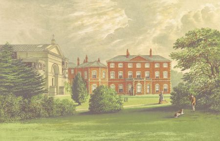
The present hall was built for William Haggerston Constable in 1757-64 to the designs of John Carr of York. The handsome seven-bay, three-storey brick Georgian house was greatly extended in 1845-8; these additions were removed in 1962-3 when the building was restored by Francis Johnson (Pevsner & Neave 1995, 412-3).
St Mary and St Everilda Roman Catholic Church Listed Grade I
A large Roman Catholic church built 1836-9 lies in the grounds adjacent to Everingham Hall, to which it was once attached. This monumental Italianate building with its striking interior was designed by Agostino Giorgioli and the work supervised by John Harper of York (ibid, 412).
Gardens and pleasure gardens
Little information on the extent and nature of the pleasure gardens has been found. In the early 19th century the pleasure ground lay to the west of the house, and this area was extended to the new road in the 1820s. It was an area of lawn, shrubberies and ornamental trees by the 1880s (see drawing in Gallery). A more formal garden with walks area existed to the north of the house, between the lake and the kitchen garden, by the mid 19th century. Nothing of this remains except a small Classical oratory in the grounds to the east of the churchyard of the Anglican church.
Kitchen Garden
A kitchen garden is mentioned in 1743 (Henrey 1986, 290) The 1765 survey refers to the ‘old kitchen garden’ which stood near to the hall (HHC UDDEV/59/34). The same year work was going on in the ‘new garden’ which was planted with ‘kidney & early potatoes, the south border between the trees with lettuce, the rest with beans & peases’ (HHC U DDEV 60/20A). The new kitchen garden covered 3 acres and was some distance to the east of the hall. It is marked on the 1765 plan (see Gallery). The steward’s account books of 1768-71 refer to filbert trees, melon frames and asparagus plants; the last were acquired from ‘Mr Perfect’ who also supplied trees; seeds came from ‘Mr Sigston’ at Beverley (HHC U DDEV 56/277).
Sometime before 1806 the kitchen garden was moved to a new site some distance to the north of the hall and south of the village street where the eastern wall still stood in 2012. The kitchen garden covered 1 acre 2 roods and 28 perches in 1806 (HHC U DDEV/70/11). J.N. Sleed’s estimate for improvements in 1826 included £170 for what appears to be a new kitchen garden covering 3 acres, and involving the building of 1188 feet of brick walls 14 feet high and a gardener’s house (HHC U DDEV 9/139). There is no evidence that this work was carried out. Entries in a memorandum book in 1826-7 refer to pine (pineapple) and peach houses (HHC U DDEV/68/48). An extensive range of hot-houses including two vineries, two peach houses and a central greenhouse were erected against the north wall of the kitchen garden in 1834 by William Crosskill, ironfounder of Beverley. The hot-houses with their iron frames were praised by J.C. Loudon in an article in The Gardener’s Magazine, which reproduces plans and elevations, partly because at £1,100 they were so much cheaper than in the south. Hot-house plants, including orchids, were sold from the gardens in the 1870s (HHC U DDEV/56/387).
The kitchen gardens evidently survived until the second half of the 20th century; the hot-houses and other features had been cleared by the 1970s when the walls appear to be still standing. Only the east wall survived in part in 2012 but the footprint of the gardens could be seen.
Park
Open Parkland
An extensive area of parkland survives to the south and east of Everingham Hall with large mature trees dotted over the landscape. Much of the area to the east of the hall has been used for arable farming in recent years but the area nearer to the house has been returned to pasture since 2003. The ditch, or ha-ha, dug in the 1730s, that divided the grounds of the hall from the parkland to the east, remains.
Plantations
Sir Marmaduke Constable was probably responsible for the oldest plantation, in the south-west corner of the park (Rookery and Pecker plantations), in the 1730s. His correspondence has references to planting oaks, elms, beech, Scotch fir and spruce.
The Belt, Brickpond, Pheasantpool and the northern part of Butcherclose plantations were created between the 1770s and 1806, along with the plantation bordering the Thorpe Road (Sandhill). By 1851 there had been added the rest of Butcherclose, Clayflat, Whincovert, Deershed and Larch plantations.
These areas were still forested in 2012 along with the area in the south-west corner of the park, east and north-east of South Lodge which was planted in the 20th century.
South Avenue
South Avenue was laid out in the 1730s and appears on Jefferys’ map of c.1771. It is not shown on any 19th century plan but was recreated through the Rookery plantation in the 20th century.
Water features
The ‘little pond’ in the Intack is mentioned in 1735 when it was being stocked with fish (Roebuck 1976, 81) and a green walk was proposed ‘all along the two ponds on each side’ in 1742 (Henrey 1986, 288). In 1765 the fishponds lay north of the hall probably on the site of the present lake. The large irregular pond shown in the centre of the Lawn east of the hall on the 1765 plan but not recorded in the 1765 survey must have been created soon after because it appears on Jefferys’ map of c. 1771. This pond had been drained and filled in by 1806.
Lake
A large serpentine lake, usually referred to on maps as the ‘fish pond’ lies east-west immediately to the north of the house and stables. It may have been given its present shape, and extent, in the mid-18th century. It existed at rather more than its present length in 1806 with a small oval pond to the east. The lake was extended eastwards as far as the Butcherclose Plantation in 1827 taking in the small pond. The lake was reduced to its present length in the mid- 20th century. The lake incorporates two small islands one of which was reached by bridges from either side. The bridges have been recently renewed. There is also a restored 19th-century boat house.
Pheasant Pool
There is an irregular area of water known as the Pheasant Pool in the southern section of the Pheasantpool Plantation in the northeast corner of the park. It was slightly larger in the mid-19th century when it included two small islands.
Other ponds
Other ponds in the plantations to the south of the open parkland and to the south of Home Farm are recent creations.
Books and articles
Everingham Conservation Area Appraisal 2007 (East Riding of Yorkshire Council)
Hall, I. 1979. Samuel Buck's Yorkshire Sketchbook. Wakefield, Wakefield Historical Publications.
Henrey, B. 1986. No ordinary gardener: Thomas Knowlton 1691-1781. London, British Museum (Natural History).
Herries, Lord. 1886. Everingham in the Olden Time. Merry England Volume 7, Issue 41 (September), 334-352.
Loudon, J. C. 1836. Descriptive Notice, accompanied by Plans and Sections, of a Range of Forcing-houses, including a Green-house, erected for William Constable Maxwell, Esq., at Everingham Park. The Gardener’s Magazine, Vol. 12, 347-352.
Neave, D. & Turnbull, D. 1992. Landscaped Parks and Gardens of East Yorkshire. Georgian Society for East Yorkshire.
Neave, S. 1991. Medieval Parks of East Yorkshire. Beverley, Hutton Press Ltd.
Oswald, A. 1968. Everingham Park, Yorkshire. Country Life 15 and 22 February, 340-344, 408-11.
Pevsner, N. & Neave, D. 1995. Buildings of England: Yorkshire, York and the East Riding. London, Yale University Press.
Roebuck, P. ed. 1976. Constable of Everingham Estate Correspondence 1726-43, Yorkshire Archaeological Society Record Series 136.
Wickham, L. 2006. Historic Garden Project: Everingham, East Yorkshire. MA Garden History Dissertation, University of Greenwich.
Primary sources
Hull History Centre (HHC): Constable of Everingham Mss (U DDEV) & Hotham of South Dalton Mss (U DDHO)
Maps
Manuscript
- Plan of Everingham 1765. Private collection
- Plan of Everingham 1806 with additions. HHC U DDEV/70/11
- Field book with plans 1834-58. HHC U DDEV/59/92
Printed
- T. Jefferys, Yorkshire, published 1772 & 1775 (1st and 2nd editions)
- H. Teesdale, Yorkshire, surveyed 1817-18, published 1828
- A. Bryant, East Riding surveyed 1827-8, published 1829
- Ordnance Survey Plans published 1855-2012
")


")


