Campsall Park, the grounds of the former Campsall Hall, is the product of one man’s ambition to have a landscaped estate that matched his main house and perceived status in life. Bacon Frank inherited Campsall in 1762 from his uncle and spent the next fifty years trying to achieve his dream. Despite employing some of the best talents available, notably John Carr to remodel the Hall and Thomas White senior to lay out the landscape, his efforts were frustrated.
His neighbours, the Yarboroughs of Campsmount, were the major landowners in the township, although Frank was the ‘lord of the manor’. He owned only a small part of the land that surrounded his Hall, with a large section to the south being common land. Undeterred, he commissioned a plan from Thomas White in 1771 that included little of his own land. For the next 25 years, he presumably tried to get the Yarboroughs to sell their land and also for them to agree to enclose the common land where they had the majority of the rights.
Finally with a second plan from White in 1796, Frank was able to start creating his desired landscape by removing public roads away from his lands. However he died before the enclosure of Campsall in 1818 that would give him the common land he needed. It was his great grandson, Frederick Bacon Frank, who completed the designed landscape from the 1860s, part of which remains today as a public park. The northern section of the park was built over in the 1950s when Askern Lodge was demolished and the Hall, stables and walled kitchen gardens were removed in the 1980s.
Estate owners
In the Domesday survey of 1086 the Manor of Campsall was owned by Ilbert de Lacy (1st Baron Pontefract), a Norman knight who held large tracts of land in the north of England. It was owned by the de Lacy family until 1311 when Thomas, Earl of Lancaster, inherited his father-in-law’s estates. The Duchy of Lancaster lands were absorbed into the Crown estate when Henry IV (son of John of Gaunt & Blanche, great-niece of Thomas) came to power in 1399.
The manor was leased out to ‘freeholders’ and ‘copyholders’ with the manorial rights belonging to the St Paul [otherwise Seyntpaull or Saintpoll] family in the 16th century. In 1535, John St Paul was recorded as having the Manors of Campsall and Carcroft and 10 messuages and 5 cottages with lands there (Collins 1887, 72). By the start of the 17th century, there were 22 freeholders across the manor of Campsall that included neighbouring settlements. The major landowners at the time were William Brigge, Leonard Huscrofte, Ralph Fretwell, Bartholomew Fletcher and John Sayle (SA BFM/956/6). The Inquisition Post Mortem of Edmund Yerburgh [Yarborough] of 9 September 1631 showed that Bartholomew Fletcher had owned Brayton Hall and 165 acres and George St Paul[e] the ‘Higher Hall’ in Campsall [possibly the manor house]. Land in Campsall had been bought by Robert Cooke from Francis Guye, with other landowners mentioned being John Huscrofte and William Cooke (BIA YM/FD/10).
In 1611, John and Henry Frank of Pontefract made their first acquisition of land in Campsall. Thomas Bartholomew Royston [or Rolston] assigned his lease of the manor to Robert Barwick and Richard Frank, John’s son, in 1628 (DA DZ MZ 62/W/31). Richard Frank died in 1661 and the estate went to his grandson, Edward (né Ashton). Edward had married his cousin, Ann Pelham, but died childless in 1695 so the estate went to his brother, Matthew.
Matthew Frank died in 1717 and his son, Richard (b c. 1698), inherited. Richard died childless in 1762 and so his nephew Bacon Frank (b c. 1739) took possession of the Campsall estate. In 1811, Bacon Frank was declared a lunatic (NA C 211/9/F66) and died the following year. His son Edward (b 1780) inherited but he too was declared insane in 1816, although legal responsibility for the estate was not settled until 1825 (NA C 211/9/F81). His mother continued to live at Campsall Hall although it was offered for rent in 1818 and in 1822, Sir Joseph Radcliffe took up the tenancy. The lease was transferred to Charles Thorold Wood in 1836.
By 1834, Frederick Bacon Frank (b 1827) had inherited the estate from his grandfather, Edward. On Frederick’s death in 1911, the Hall was occupied by his second wife, Mary, the niece of his first wife. In Frederick’s will, the estate was to go to his wife for her lifetime and then to any children. However, there were no children of either marriage, so the heir was Francis Elliot Walker, his first wife’s brother (The Illustrated London News, 11 November 1911). In 1924 the Campsall and Earlham Estate Company, with a capital of £10,000, was set up by Francis to ‘acquire the reversionary interest of Sir F.E. Walker…in the real and personal estate of Mr F. B. Frank, late of Campsall Hall…and to develop the estate’ (The Yorkshire Post, 4 August). When Francis died in 1928, his daughter and sole heir, Helen Marjorie Walker, took over the main directorship of the company.
Mary Bacon Frank lived at Campsall Hall until 1941 and on her death the following year, the estate passed to Helen Walker. The Hall was put up for sale in 1950, after being converted into two houses: ‘The Library House’ and ‘The Saloon House’ (effectively the two west wings) with a proposal that the ‘remainder of the Hall will be demolished’ (Sheffield Telegraph, 7 September). In 1952, the Campsall and Earlham Estate Company was wound up (The London Gazette, 1 April) and by 1959, parts of the building had been converted into flats. In 1971 Helen Walker died and the estate was sold by her heir to developers, with the parkland being bought by Council in 1977.
Key owners responsible for major developments of the designed landscape and dates of their involvement:
Richard Frank (1628 – 1661)
Edward Frank, né Ashton (1661 – 1695)
Matthew Frank, né Ashton (1695 – 1717)
Richard Frank (1717 – 1762)
Bacon Frank (1762 – 1811)
Edward Frank (1811 – 1816)
Frederick Bacon Frank (1850 – 1911)
Early history of the site
In 1086 the Manor of Campsall, owned by Ilbert de Lacy, contained 24 households and paid 5 geld units of tax. Together with its woodland of 1 x 0.5 leagues, it was a sizeable settlement. By a royal grant dated 22 June 1294, Edward I gave the right to Henry de Lacy, Earl of Lincoln, and his heirs to hold a Thursday market, an annual fair of 4 days' duration and also ‘free warren’ [right to hunt game] in Campsall (DA DZ MZ 62/W/32).
In 1481, the Church at Campsall was given by Edward IV to the Benedictine nunnery of Wallingwell in Nottinghamshire (Lawton 1842, 179). In response, on the 8 February the following year, Thomas Rotherham, Archbishop of York, decreed that a Vicar should be appointed from Cambridge University on a salary of 25 marks per annum, together with a portion of the Rectory for his ‘mansion house’ (BIA Abp Reg 23f.114 recto). On the dissolution of the nunnery in 1537, the prioress entered into a covenant with Richard Oglethorpe demising to him the entire monastery and all its possessions for the term of twenty-one years, together with the parsonage of Campsall (Dugdale 1846, 298).
The first lands were bought in Campsall by the Frank family in 1611, when Bartholomew Fletcher sold John and Henry Frank of Pontefract ‘all those four closes commonly called Brayton Pastures (about 30 acres), Pype Ing and Sower Inge, lying together in the townships of Campsall, Askern and Mosseley’ for £160 on the 21 November (SA BFM/135a). In 1628, Thomas Bartholomew Royston [or Rolston] assigned his lease of the manor to Robert Barwick and Richard Frank (DA DZ MZ 62/W/31). A survey of 21 April 1627 listed this as:
The manor house and the demesnes thereonto appertaining were in lease in April last for seven and forty years. The content and qualities of the demesnes are mentioned by the lease to be CLXII [162] acres and one rood of arable lands and ten acres and three roods of meadow and pasture, which retains agistment [right to charge for grazing of cattle] (SA BFM/956/7)
Richard Frank probably moved to Campsall at this point as his son, Richard, was baptised there in 1627. He lived in the building that would become Campsall Hall that is depicted in Buck’s sketch of c. 1720 (Hall 1979, 64). A deed of 1677 (SA BFM/935) referred to his ‘garden wall’ and this was probably the court next to the west front of the Hall shown in the drawing. From 1653 to 1660, Richard Frank bought small parcels of land (SA BFM/125a & 127a) and exchanged land with Thomas Yarborough (SA BFM/126 & 128). Richard’s grandson, Edward, continued to acquire land (SA BFM/942) and may have developed the immediate grounds as a deed of 1696 refers to ‘Mr. Frank's gates on the South’ that led to his ‘foldstead on the east’ (SA BFM/937).
The estate at Campsall was recorded as being 9 oxgangs [c. 113 acres] in 1714 (WYASW JG M93). Matthew Frank gives a description of his lands in Campsall two years later:
‘Manor House and Lands as follows: 31½ acres of arable land lying in the 3 several fields of Campsall viz. in the west field 16½ acres, in the south field 12 acres and in the east field 3 acres. Two closes called by the name of New Closes the farther close next to the road which is about 6 acres, toward the bottom of the other new close being arable land, Bracken flatt arable land. 2 Wood Gap closes adjoining to Barnsdale the larger thereof is pasture ground and the latter arable around the three closes called by the name of Sailes, the lesser arable; Hardingcrofts pasture the two bottom closes the higher close arable land: Dovecoatyard and Orchard Close Carr Orchard and Garden’ (SA BFM 1294)
In 1715, the accounts noted that they ‘paid [for] 31 trees and to the gardiner, £1 11s 6d’ (WYASW JG M93) and two years later paid ‘the gardener for setting the trees, 3s 6d’ (Letter Anne to Richard Frank, 15 July). This may refer to the orchard mentioned above and shown on the map of 1720 (DA DZ MZ 30/P2, Figure 1). Any further work on the grounds though was delayed by the decision to rent out the property in 1721 (SA BFM/1342/2). Richard Frank was completing his studies at Cambridge and Gray’s Inn and there were indications that they had invested in the South Sea Company, whose share price collapsed in late 1720. In Anne Frank’s letter to her son on 11 January 1721 she asked him to give her ‘some good news about the South Sea Stock’ (WYASW JG M93). The tenant was John Clark and he paid £60 rent for ‘Manor House and land’ (WYASW JG M18 Box 2) and payments continued by him until 1726 (SA BFM/1286).
By 1723 Richard Frank once more was buying and exchanging land at Campsall. He acquired a ‘cottage on the north side of the churchyard which I purchased of William Winteringham’ (WYASW, JG M93) and he exchanged 3 acres in Pillory Ash Flatt for 6 acres in Langley and Hill Closes with Thomas Yarborough (SA BFM/130 and DA DZ MZ 30/A6). He was also reshaping the land around him and in 1730 paid John Dickinson £7 9s to survey his estate at Campsall although this plan has not survived (SA BFM/1286). In a written survey of 7 October 1731, he recorded that he exchanged one property for ‘a cottage at my gates, which I have since pulled down’ (WYASW, JG M93). In 1736 his landholding in the township of Campsall was just over 144 acres or 12½ oxgangs (SA BFM/236). By then Frank had turned his attention to draining Littlemoor, the area immediately south of his residence. Although common land, its management clearly affected his lands as he points out in his petition to the Commissioner of Sewers:
‘[the] drain anciently…maintained for carrying off the…water…from the…common and grounds [adjacent]…[due to the] neglect of the several persons in sufficiently scouring, widening and deepening the…[drain, it] is become…incapable of carrying off the water…[so the] common and grounds…are overflowed and greatly damaged (SA BFM/236)
Frank was also preparing to plant trees to aid in the drainage scheme for Littlemoor in the following places (26 September 1736, SA BFM/236):
Langley Hill Closes outside – grafted elms [English elms on wych elm rootstock] – 61
Harding Crofts – ash or W [wych?] elms – 7
Bracken Flatts – S [or possibly E., i.e. English] elms – 11
Hall Lane and field – grafted elm – 6
At the same time, he was clearing some areas of trees with a view to selling the wood (SA BFM/71A):
Alders: 22 in Brayton pasture south side, 7 in Brayton pasture next to lane, 14s 6d; 2 in Potter’s Close north side, 5 in Potter’s Close south side, 4s 8d
Maples: 8 in Upper Harding Crofts ?end, 9s 6d; 6 in Potter’s Close north side, 6 in Potter’s Close south side, 12s 4d; in Dalegate Close, 3 in Brackens Flatt east side, 13 in the further new close beginning on the east side and going round the 4 closes, £1 16s 8d
Total 73 trees, value £3 17s 8d
In 1738 Richard married his cousin, Margaret Frank, who was the co-heiress of her father’s estate. This gave him additional funds to develop his estate and he continued to consolidate his landowning in 1744 by exchanging more land with Thomas Yarborough (SA BFM/134a). He was also considering building a new Hall. There are a series of drawings from 1746 for designs of a new building, attributed to John Carr (1746/7, RIBA 65914-65922), James Paine (1752, RIBA 65923) and Edward Hutchinson (1754-6, RIBA 65932-65935). There are three further drawings, again attributed to John Carr, that are described as ‘alterations and additions to Campsall Hall’ (1746, RIBA 65911-65913).
Alongside the new or remodelled Hall, he was also planning to reshape the grounds as there is a drawing for a proposed rectangular pond (RIBA 65941). The plan is not dated or signed and there is no indication as to its potential location. It was to be surrounded by trees set in just under two acres. It measured about 94ft wide, 203ft long and 6ft deep with a ‘parade’ [walk] 6ft wide around it. In addition, there was a plan for a square garden possibly divided into four with a pool in the centre (RIBA SC7/10). It was designed to go in place of some cottages and garth that Frank had acquired from Samuel Potter in 1731, as noted in his survey of that year: ‘He was tenant to Samuel Potter the little coupled cottage below Arlington’s and exchanged this year to William Mangal’ (WYASW, JG M93).
While it is not known whether Richard Frank’s plans above were carried out, in the accounts for 1747-8 (SA BFM/1288), there are payments to garden labourers including: ‘paid 2 Askern hedgers for stubbing and pilling [removing trees] in the Orchard Close, Carr and Hill Close, 17s’. In 1754, he paid for ‘levelling work at the [new?] stables’ (WYASW JG M93) but did not carry out any modifications to the main house.
Chronological history of the designed landscape
1762 – 1795On inheriting his uncle’s estate in 1762 and following his marriage to his cousin the following year, Bacon Frank clearly wanted an improved house and landscape. He first called in John Carr to remodel the house in late 1762 (SA BFM/1314/60 & 67). While this was being done, the landscaping of his estate appeared to be confined to Barnsdale, 1½ miles to the west, where he had ancient manorial rights of ‘free warren’. On the 17 June 1762 he paid William Perfect, the nurseryman, ‘Gardener and Trees, £2 10s 1d’ (SA BFM/1289), so perhaps Perfect had given advice as well as supplying stock. On 14 November the following year, he paid ‘Mr Perfect for Scotch Firs planted in Spring 1763 Garrow Hill Barnsdale, 3482 plants, 1 foot high at 7s 6d/100, £1 2s 1d’ (ibid).
In front of his newly remodelled house, Frank wanted to improve the entrance from the village. As the land in front belonged to Thomas Yarborough, Frank benefited from the former’s generosity as this document shows:
An account of the ground in Joseph Bailey Tyth(?) Garth to which Mr Yarborough made Mr Frank a present in order that he might have a better way to his court before his house being 165 yds as now measured containing 8 perches, Aug 15 1764 (DA DZ MZ 30 A7)
By late 1764, Frank had turned his attention to a new kitchen garden in the former Dovecot Yard. This may have been designed by John Carr, who remarked in his letter of 7 November, ‘I did not like the sweep(?) in the garden wall where the doorstead was intended, the wall should go level and the doorway be placed in it. I think it’s a good wall’ (SA BFM/1317/11). Carr was later responsible for the walled kitchen garden at Wentworth Woodhouse and saw the construction of the one at neighbouring Stapleton Park at this time (Hall 1989 & Lynch and Wickham 2017, 9).
Preparation started in January 1765, when the accounts recorded the payment to ‘Handley and others for stubbing 4 of the elm trees in the Dovecoat yard, £1’ (SA BFM/1289) with a further 17 elm trees removed the following month (ibid). There are more entries in the accounts (ibid):
11 May 1765 Paid Harrison for building the eastern half part of the south garden wall being 72 yards in length containing 49 roods at 4s per rood, £9 16s & two arches over door, 2s
24 Nov 1765 Paid Roebuck, mason, for building the wall on the west north and east sides of my garden and for the hot house - the whole at 4s per rood allowing 1s per yard for the flues (?) and allowing & coping laying on etc, £44 4s 1d
The area around the new walled garden may have been landscaped at the same time. On the 26 February 1765, he ordered 1000 beech and 500 Scotch firs from Perfect’s nursery (SA BFM/319/13) and on the 17 April, paid William ‘Senyer, blacksmith, for the out fence wall in the shrubbery about 7 feet high at 3s per rood undashed, £7 12s’ (SA BFM/1289). He bought some more trees from William Perfect in October (SA BFM/1289 & SA BFM/1319/52) and on the 30 Dec 1765, noted that he had ‘paid gardener for labourers employed about garden & house, £73 17s 3d’ (SA BFM/1289).
Like many fellow landowners, he was keen to grow pineapples and with his new hothouse now operational, his accounts recorded his purchases of plants and related items (ibid):
20 Jan 1766 Paid Daniel Cloth for stove [hot house] shutter, £5 1s 2d
25 Jan 1766 Paid [John] Shaw for garden pots, £11 2s
30 Apr 1766 Paid Joshua Sherd 30 Pine Plants for Mr [Radcliff] Medleys at 3s, £4 10s
17 May 1766 Paid Mrs Wrightman [of Cusworth] for pine plants, £7 7s 3d
7 Oct 1766 Paid John Pye, Lord Scarborough’s gardener [at Sandbeck] for pine plants, £4
19 Sep 1767 Paid Mr [John] Smyth’s gardener [at Heath Hall] for young pine plants, £1 1s 5d
31 Dec 1767 Paid Woodhouse of Stubbs for bark for stove @5s, £2
In addition, he bought 100 pineapple plants from Robert Teesdale, gardener at Castle Howard (7 Sep 1766, SA BFM/1320/78 and 16 Sep 1766, SA BFM/1320/81).
In the first three months of 1766, Frank spent money on hedging: ‘28 February, Paid Heaton and Smeaton for hedging, £3 18s 6d ‘; ‘7 March, hedging by Foster, £1 18s’ and ‘27 March, paid Richard Firth for Long Plantation hedge making, £21 1s 1d’ (SA BFM/1289). Given the reference to ‘Long Plantation’, this was likely to be further work at Barnsdale.
By 7 March 1766, he had engaged a (new?) head gardener, Thomas Harvey, at an annual salary of £16 (ibid). Work continued the following year with the purchase of trees and seeds from William Perfect on 16 February at a cost of £41 16s and asparagus plants costing 13s 6d from ‘Jarrat’ on the 12 May (SA BFM/1289). On the 30 December of that year, Frank noted: ‘Paid the gardener for labourers’ wages etc in the garden, £139 18s 10½d’ (SA BFM/1289). By July the following year, he was seeking to engage an ‘under Gardener’ and William Perfect suggested an employee of his, William Cockram, to work for Thomas Harvey at 8s [possibly per four] weeks (4 July, SA BFM/1322/31).
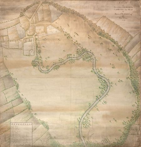
Bacon Frank though had grander plans for his estate and in 1771 commissioned Thomas White to prepare an improvement plan for his grounds (BIA RBU/2/22/1, Figure 2). White indicated the existing boundaries by a dotted line in pencil and in the absence of accounts for the period, this showed what had already been laid out. Comparing it to the previous map (DA DZ MZ 30/P2, Figure 1), the boundaries from 1720 are largely intact. The cottages on east side of Siblin Lane have been removed, although they are still shown on the Jeffrey’s map of c. 1771 (Figure 3). The walls of the front court remained apart from the southern ones. It is clear though that the later lake or ‘fishpond’ was not in place as the old boundaries crossed it at numerous points.
White’s proposal was quite ambitious as it sought to move the two public roads from Askern to create more parkland to the east and to the north. To the south, the plan involved including Littlemoor as an area for parkland and using the existing drain on it as a basis for the water feature. However Frank only owned a section of the land shown in the plan, mainly in the northern section. The land to the east was still field strips in multiple ownership and Littlemoor was common land, the bulk of the rights owned by Yarborough (SA BFM/236). In the plan, the existing walled kitchen garden was to be extended to the north and to the east.
A map from 1795 (DA AB ARCH/1/370) showed that part of the planned lake or ‘fishpond’ had been created at this point but it had kept inside Frank’s boundaries. There was also some landscaping around the lake to the south and along the former Siblin Lane shown on c. 1800 estate map (BIA RBU/2/22/3). This may have been put in place around 1773 as indicated in a letter from William Perfect:
‘Its now a good season for removing evergreens in general and if you please to accept a waggon’s load of large yews to fill up your plantations, they are at your service, will also give you a waggon load of Balm of Gilead Firs [Abies balsamea] and Lord Weymouth’s Pines [Pinus strobus], which will make good any that failed last year…the yews and firs are in Carlton Field Nursery’ (19 April 1774, SA BFM 1328/35)
Although the walled kitchen garden was unchanged, the Hall had been extended and was shown on White’s plan of 1796 (BIA RBU/2/22/2). This may have been a result of the damage caused by the fire in December 1789 at the Hall. The World reported on the 4th that ‘The house of Bacon Frank Esq of Campsall in Yorkshire has been on fire. Five rooms were burnt, and the rest much damaged’. The architect is not known but a likely candidate is William Lindley who designed Askern Lodge around this time.
A survey from 1795 (DZ MZ 30/S18) listed the following for Bacon Frank: ‘House & Garden, Orchard Close, Fish Ponds & Pleasure Grounds; 29a’ and ‘Fold Yard and Stable Buildings; 1a 1r 34p’ with a total land area for Frank in Campsall of 284a 1r 29p. This was almost double the landholding in 1736 but the bulk of it was concentrated in Barnsdale.
1796 – 1818In 1796, Frank commissioned a second improvement plan from Thomas White (BIA RBU/2/22/2, Figure 4). This again planned to extend the fishpond south and include parts of Littlemoor that Frank still did not own. However the opportunity to expand the parkland to the east and north was made possible by an agreement between Bacon Frank and Elizabeth Yarborough on the 8 September that year to alter the roads in the village (WYASW QS1/139/4, Figure 5). These plans mirrored the suggestions by Thomas White for the boundaries in his plan, so either he was reflecting the change or had proposed it.
Frank had also made some alterations to his buildings that year, most notably the extension of stable/service buildings alongside the graveyard wall shown on White’s plan. The architect is unknown but they may have been by William Lindley, who had been John Carr’s assistant and was now a leading architect in his own right. By c. 1800 Frank had acquired the area north of walled kitchen garden, labelled as ‘Garth’ or No 43 on the estate plan and the areas to south east of fishpond (Nos 3, 169 & 171) (BIA RBU/2/22/3, Figure 6). The road diversions were completed by 21 April 1800 (WYASW QS1/139/4) and Askern Lodge, designed by William Lindley, was erected next to the new road (WYASW JG/M93, Figure 7).
In order to implement Thomas White’s plan, Frank had acquired part of Churchfield to the north and east from Elizabeth Yarborough and other landowners to enable construction of the drive from the new Askern Lodge. This was done c. 1798, as land tax records show that the last remaining independent landowner, John Coe, sold his land after June 1797 (WYASW QE13/8/4). The valuation of the estate in 1802 (DA DZ MZ 62/X/1) referred to an area ‘Now in Park’ of 36a 6r 22p. This would match the area marked as No 6 on the c. 1814 map of Campsall (DA DDCY/1/P17, Figure 8). A later map of 1818 (DA PR/NOR/4/1-2, Figure 9) showed a shelter belt along the new road and clumps of trees in the middle, with some along the line of the former road. It also showed a second walled kitchen garden to the northeast of the main one, marked ‘209’.
Frank had also exchanged the area to southwest known as ‘Beevers’ belonging to the Yarboroughs, marked on the map as Nos 58 and 59 (DA DDCY/1/P17, Figure 8) during the enclosure of 1818. This meant he could construct a lodge on the Sutton Road for a southern approach to the house as per Thomas White’s plan (BIA RBU/2/22/2, Figure 4). Although records are sparse from this period, an account from Bacon Frank’s unpaid debts in 1811 showed that further landscaping started in early July 1802 and continued for the next 8 years:
'Knapton, Thomas on balance of account for wages due to him as the [possibly landscaper] and Head Gardener from October 1799 to midsummer 1810=10 years, 8 months and 19 days at 25s per month; for additional wages for overlooking and keeping account of the work done by the labourers etc from 5 July 1802 to midsummer 1810 at 10s a year after interest agreed to be paid - £227 4s 10d, principal sum £165 1s 5d’ (WYASW JG001932)
On the 18 February 1805, wood was offered for sale ‘upon estates in Campsall’ (The Leeds Intelligencer), although this may have been from earlier plantations in Barnsdale from the 1760s. The land tax records (WYASW QE13/8/4) show that Frank was steadily building up the land for his own use. In 1797, the sum paid for lands occupied by him was £6 8s. By 1805, this had increased to £8 19s 3d. Finally with the enclosure of Campsall, completed in 1818, Edward Frank added Littlemoor to his landholding from George Cooke-Yarborough, as shown on the map (DA PR/NOR/4/1-2, Figure 9). Despite this, he did not follow White’s plan and instead extended the fishpond to the west to create a second lake with bridge dividing the two parts (Figure 9).
Edward Frank was declared insane in 1816 and although his mother continued to live at Campsall Hall, on the 5 March 1818 the property was offered for rent:
1819 – 1910‘To be let furnished for a term of seven years, Campsall House, a most capital and spacious mansion, the residence of the late Bacon Frank Esq…with gardens, hot houses and every requisite out-building. There are eighty acres of meadow and arable land, surrounding the house, in a high state of cultivation and three manors extending over nearly six thousand acres of land, abounding with game…sixty acres of land may be had in addition if required’ (The Morning Post)
Sir Joseph Radcliffe had taken up the tenancy of Campsall Hall in 1822 (WYASW QE13/8/4) and with the settlement of the legal case of Edward Frank’s lunacy three years later, more work continued on the landscape. By 1831, the West Lodge had been put in place, together with the carriageway from it to the Hall. This went via a bridge that divided the two sections of the fishpond. There was further landscaping around it (No 148 on survey), together with more plantations at the southern end of the shelter belt and in the southern part of Littlemoor (No 131). A new avenue of trees had been planted on the opposite side of the road to the new lodge. Next to the second kitchen garden to the north, was now an orchard with the area of these two walled enclosures being just over 1½ acres (No 102). The area in between the two walled gardens was now landscaped. The 1831 survey showed that the estate leased to Sir Joseph Radcliffe was 104a 2r 8p, with a further 16a 2r 34p ‘in hand’ [i.e. part of the designed landscape] (BIA RBU/2/22/8, Figure 10).
On the 30 December 1836, the lease was transferred to Charles Thorold Wood. It comprised Campsall Park, the house, outbuildings and adjoining land and other parcels of land in Campsall for 12 years at a rate of £250 per annum (SA BFM/334). Wood was to occupy it until his death in 1852, when Frederick Bacon Frank moved back to Campsall. Work had already begun though on further development of the landscape. On the 1831 survey (BIA RBU/2/22/8) are later notes giving the work carried out:
1850? New plantation (and ‘osier beds’, willows for coppicing) in later ‘Fishpond plantation’ [No 147 on survey]
1854 New plantation just south of fishpond [No 139]
1859 Part of ‘Littlemoor Plantation’ cut down [no 93], later replanted?
1860 Osiers planted at southern end of former Littlemoor [‘The Ings’ on survey]
1862 New plantation ‘Exhibition Plantation’ east [No 145], plantation next to The Ings [No 128 part]
1865 New plantation ‘Exhibition Plantation’ west [No 145]
1866 ‘Planted with larch, Scotch and Austrian [pine] in January and February in ‘Park Plantation’ [section of No 118 next to 109]
Before 1891, the houses had been removed on the main street (Nos 97, 98 & 99 on the 1831 survey) and a ‘Pinetum’ added between Hall and Fishpond (1st edition 25” OS map, Figure 11).
Later historyFrederick Bacon Frank died in 1911 and for the next forty years the landscape remained unchanged. During the Second World War, the Hall was requisitioned and as its owner did not want to live there, the main building was later turned into flats. By 1960, in the northern section of the parkland was a new housing estate and Askern Lodge was demolished in 1956.
Following the death of Helen Walker, the last family owner in 1971, the remaining estate was put up for sale and sold to a development company (Smith 2012, 17). The company applied for permission to build houses in the walled gardens to enable them to upgrade the Hall which was denied, as were applications for grants (ibid). The hall became vacant and began to deteriorate. Although the local council discussed buying Campsall Hall and remaining land, in 1977 they just bought the parkland and turned into a public park.
The hall and walled gardens were bought by another development company in 1977, who were given permission to build homes in the gardens. The Hall and stables were finally demolished in September 1984, despite efforts to save the buildings (Smith 2012, 18). The land on which they stood was used for more housing development.
Location
Campsall is situated 11.5km (7.5 miles) north of Doncaster.
Area
The former Hall, stables and surrounding historic gardens and parkland (Figure 12) covered c. 90 hectares (220 acres).
Boundaries
The northern boundary was from Askern Lodge to the junction of Churchfield Road and Campsall Balk (to Norton). The eastern boundary ran along Churchfield Road until SE 554 138 and then to southern extent of Park Plantation. The southern extent of the estate followed the plantations (Langleys, Exhibition and Common) until SE 551 128. The western boundary followed the division between Campsall and Sutton townships from SE 550 130 to the southern edge of Beevers Holt plantation. It then continued from West Lodge along the northern edge of Beevers Plantation to the village main street. From there it carried on to Askern Lodge via the village road.
Landform
The site of the mansion, immediate gardens and lake lies between 8m and 11m AOD. The ground slopes slightly down to the south with the northern extent of the former parkland at 20m AOD and the southern end at 7m AOD. The ground also slopes down from east to west from Churchfield Road to the lake. Campsall Park’s underlying geology is Brotherton Formation (limestone sedimentary bedrock) in the northern section and Roxby Formation (mudstone bedrock) in the south where it is overlain with clay, silty superficial deposits. The northern part has freely draining lime-rich loamy soils with moderate fertility and the south has loamy soils with naturally high groundwater and low fertility.
Setting
Campsall Park lies in Doncaster Council’s Local Characterisation Area of C3 – Carcroft to Norton Limestone Plateau. This area is defined by its slightly raised elevation and the magnesium limestone geological deposits. This is a strongly rural area in which farmland predominates with mainly arable fields. The core of the village and the western part of the park are part of the Conservation Area.
Entrances and Approaches
Askern LodgeBuilt c. 1800 to a design by William Lindley (Figure 7) and demolished in 1956. From here the carriageway went south and then west to the front of the Hall (Figure 11)
West LodgeBuilt between 1818 and 1831. Designer unknown, building extant. From here the carriageway went east to the southern edge of the lake with four Wellingtonias flanking the entrance, of which two survive together with the remains of a third (Figure 12).
Principal Buildings
Campsall HallDating from the early 17th century, it was remodelled by John Carr in the 1760s. It was demolished in 1984.
Stable block & service buildingsPossibly dating from the early 17th century, they were remodelled in 1754 (WYASW JG M93) with further additions in the 1790s (BIA TER/F/Campsall). They were demolished in 1984.
Gardens and Pleasure Grounds
The 17th century hall had an enclosed courtyard to the west and an orchard to the south (Figure 1). These were only removed following the landscaping of the 1770s when the fishpond and parkland were created. Little of White’s 1771 plan appears to have been implemented with the exception of the pleasure grounds running south from the Hall to the western end of the lake. His plan included a menagerie next to the lake but there is no evidence that it was built. Immediately to the south of the Hall and the walled kitchen garden was an area of shrubbery and possibly trees.
By 1831, the area around the Hall was described as ‘lawn and shubberies’ (BIA RBU/2/22/8). Photographs from c. 1900 (Smith 2012, 16) show the area next to the west front of the Hall with lawn with flowerbeds and a long herbaceous border along the southern wall of the kitchen garden. In the late 19th century, a fashionable ‘pinetum’ had been added to the west of the original pleasure grounds (Figure 11).
Kitchen Garden
The first walled kitchen garden was built in 1765, possibly to the designs of John Carr, and measured 1.65 acres. It remained unchanged (Figure 11) despite recommendations by Thomas White to enlarge it (Figures 2 and 4). It had at least one operational hothouse by 1766, where pineapples were grown. A range of buildings is shown on the 1818 map in the northern section (Figure 9), with an additional smaller one on the southern wall by 1831 (Figure 10). More glasshouses were added to the northern part by 1849 (1st edition 6” OS map). A second walled garden was added to the northeast in the 1810s. The eastern curved wall of the main kitchen garden, together with the entrance opposite the church survives.
Park and Plantations
Campsall ParkBy 1720, this consisted of ‘Orchard Close’ and ‘Carr, belonging to Frank’ to the east of the Hall and was less than 20 acres. Langley Close and Hill Close were added in 1737, through exchange of land with Thomas Yarborough. By 1795, it had only expanded marginally to the east and west. However by 1802, Frank had managed to add another 36 acres and with the enclosure of 1818, the Park covered about 60 acres by 1831. The northern section is now built over with housing but the southern part around the lake survives. A few large trees including a Wellingtonia survive just south of the site of the former Hall, otherwise the area is mainly grass with recently planted trees.
In front of the site of the former Hall was a stone built haha with ditch. This largely remains in situ following the demolition of the Hall and the construction of houses on the site, although it may have been rebuilt or made taller.
Littlemoor CommonIn 1818, Cooke-Yarborough exchanged with Edward Frank his right to 71 acres here. In addition, Frank already owned 6 acres and exchanged 7 acres with the church (DA PR/NOR/4/1-2). This is now mainly farmland, with a small section to the northwest remaining as parkland.
Park PlantationThis was a shelterbelt of just over 8 acres, put in following the construction of the new road c. 1800. Extended to the south in 1866.
Langleys PlantationThis was partially in place by 1818 and by 1831 covered just under 6 acres.
Fishpond PlantationThe section immediately south and to the northeast of the fishpond was in place by c. 1800 and probably dates to the construction of the lake in the 1770s. The northern section had been cleared by 1818 but the southern part expanded between 1850 and 1854.
Exhibition PlantationA small section (½ acre) was in place by 1831 but the main area of 3½ acres was planted between 1862 and 1865.
Common PlantationPlanted by 1831, it covered five acres.
Beevers Holt/Beevers PlantationBeevers Holt Plantation was put in before 1795 by the Yarborough family and covered just over 3½ acres. It was exchanged during the enclosure of 1818. By 1831, the Beevers Plantation of c. 5 acres had been laid out to the north. However the northern section was removed in 1859.
PinetumThe eastern section had been laid out in the first phase of landscaping in the 1770s. It was expanded before 1891, with addition of the newly fashionable conifers such as Wellingtonia (from a survey carried out by Doncaster Council in 2000). Some of these remain together with a Scots Pine. Along its eastern edge is a haha with a small stone wall and ditch, most of which remains.
Water
The ‘Fishpond’ was laid out initially after 1771 (eastern section), this was expanded between 1802 and 1818 to add the western part. To the south a haha was put in with a small stone wall and a drainage ditch, parts of which still remain.
Books and articles
Collins, F. ed. 1887. Feet of Fines of the Tudor Period, Part 1. Worksop, Robert White.
Dugdale, W. 1846. Monasticon anglicanum Volume 4. London, James Bohn.
Hall, E. 1986. ‘Hot Walls: An investigation into their construction in some northern kitchen gardens’, Garden History 17, 1: 96-107.
Hall, I. ed. 1979. Samuel Buck’s Yorkshire Sketchbook. Wakefield, Wakefield Historical Publications.
Lawton, G. 1842. Collectio rerum ecclesiasticarum de dioecesi Eboracensi [Collections relative to Churches and Chapels in the Diocese of York] London, J. G. and F. Rivington.
Lynch, K. and Wickham, L. 2017. Stapleton Park, Selby District Historic Designed Landscapes Project. Yorkshire Gardens Trust.
Smith, G. 2012. Campsall Hall: An Illustrated History. Alexandria, Harpocrates Publishing.
Primary sources
Borthwick Institute for Archives (BIA)Abp Reg 23 Archbishop Register, Thomas Rotherham 1480-1500
RBU/2/22/1 Thomas White, A Plan of Alterations Designed for Campsall, the seat of Bacon Frank Esquire, 1771
RBU/2/22/2 Thomas White, A Design for the Improvement of Campsall, the seat of Bacon Frank Esqr, 1796
RBU/2/22/3 [Anon.] Sketch Plan of Campsall Estate, c. 1800
RBU/2/22/8 Survey of the Revd Edward Frank's Estates at Campsall Sutton etc, Yorkshire, Henry Sanderson, Surveyor, Sheffield, June 1831.
TER/F/Campsall Terriers of Campsall 1786, 1809
YM/FD/10 Inquisition post mortem of Edmund Yerburgh [Yarborough] of Balne Hall, 9 September 1631
Doncaster Archives (DA)AB ARCH/1/370 Plan of Campsall, 1795
DDCY/1/P17 Campsall township map. Endorsed 'Campsall Enclosure', c. 1814
DZ MZ 30/A6 Campsmount Estate account book 1720 – 1745
DZ MZ 30/A7 Campsmount Estate account book 1730 - 1770
DZ MZ 30/P2 A map of Campsall Fields, 1720
DZ MZ 30/S18 A survey of Campsall listing all owners, field names, areas and names of tenants, 1795
DZ MZ 62/W/31 Details of Mr Rolston's lease [of Campsall manor] to Mr Frank
DZ MZ 62/W/32 Copy of a royal grant dated 22 June 1294
DZ MZ 62/X/1 Copy valuation of Mr. Frank's estate at Campsall for an assessment, 1802
PR/NOR/4/1-2 Campsall, Askern and Norton: enclosure award (with map) 1818
National ArchivesC 211/9/F66 Bacon Frank esq of Campsall, Yorkshire: commission and inquisition of lunacy, into his state of mind and his property, 2 May 1810
C 211/9/F81 Revd Edward Frank, clerk of Winthorpe Hall, Nottinghamshire: commission and inquisition of lunacy, into his state of mind and his property, 11 July 1825
North Yorkshire County Record Office (NYCRO)ZDU[18]42 Jeffrey’s map of Yorkshire c. 1771, Plate 18
Royal Institute of British Architects (RIBA)65911 – 65913 Designs for alterations and additions to Campsall Hall, Norton, Yorkshire, c. 1746, attributed to John Carr
65914 – 65922 Alternative designs for replacing the old house by a new one, Campsall Hall, Norton, Yorkshire, 1746/7, attributed to John Carr
65923 Alternative design for replacing the old house by a new one, Campsall Hall, Norton, Yorkshire, 1752, attributed to James Paine
65932 – 65935 Designs for a new house at Campsall Hall, Norton, Yorkshire, 1754, attributed to Edward Hutchinson
65941 Design for a pond at Campsall, Norton, Yorkshire, n.d.
SC/7 10 Survey plan of plot of land (including a fishpond bounded on 2 sides by Little Moor Common), n.d.
Sheffield Archives (SA)BFM/71A Agreements for sale of woods and valuations of woods. Campsall 1736-1741
BFM/125a John and Ann Pinder to Richard Frank, one cottage with appurtenances in Campsall, a garth in Sibling Lane and named parcels of land in Campsall, 21 October 1653
BFM/126 Thomas Yarburgh to Richard Frank, seven acres in the Westfield of Campsall, in exchange for three acres in the East field, 5 February 1657
BFM/127a Robert Wintringham to Richard Frank, four acres and one rood of land in the Milne field at Campsall, 4 August 1659
BFM/128 Thomas Yarburgh to Richard Frank, six acres of named parcels of land within the South and West fields of Campsall in exchange for other land in Campsall, 29 February 1660
BFM/130 Thomas Yarborough of Campsall, esquire to Richard Frank of Campsall esquire, reciting deed of even date whereby Frank conveyed to Yarborough 6 lands containing three acres lying in Pillory Ash Flat, formerly part of the South or Mill Field. Two closes of meadow called Langley close and Hill close containing 6 acres, 25 November 1727
BFM/134a Deed of exchange between Frank & Yarborough for various parcels of land in Campsall fields, 6 July 1744
BFM/135a Bartholomew Fletcher to John and Henry Frank, land in the townships of Campsall, Askern and Mosseley, 21 November 1611
BFM/236 Littlemoor drainage scheme with plan by R Frank, 1735-36
BFM/334 Lease. Frederick Bacon Frank and guardian Caroline Frank to Charles Thorold Wood, Campsall Park, the house, outbuildings and adjoining land, and other parcels of land in Campsall; for 12 years for £250 per annum, 30 December 1836
BFM/942 Anthony and Anne Rhodes surrender three shops in Campsall and one cottage and half an acre in Southfield to the use of Edward Frank for ever, 23 October 1677
BFM/935 Anthony Rhodes to Edward Frank, messuage and a parcel of meadow in Campsall, 23 October 1677
BFM/937 Thomas Yarburgh to Sir George and Dame Anne Tempest, cottage in Campsall in exchange for a cottage in Morris Lane, 10 June 1696
BFM/956/6 Mr. Currer's survey of the Manor of Campsall. n.d. [c. 1605 – 1610]
BFM/956/7 Rental of parcels of land and ancient possessions of the Duchy of Lancaster in manor of Campsall, 1627
BFM/1286 Cash book of Richard Frank of Campsall, 1725-31
BFM/1288 Cash book of Richard Frank of Campsall, 1747-51
BFM/1289 Cash book of Bacon Frank 1762-67
BFM/1294 Memoranda book relating to Frank's Campsall estate, 1608-1716
BFM/1314/60 Letter from John Carr to Bacon Frank, 27 September 1762
BFM/1314/67 Letter from John Carr to Bacon Frank, 13 November 1762
BFM/1317/11 Letter from John Carr to Bacon Frank, 7 November 1764
BFM 1319/13 Letter from William Perfect to Bacon Frank, 26 February 1765
BFM/1319/52 Letter from William Perfect to Bacon Frank, 31 October 1765
BFM/1320/78 Letter from Robert Teesdale to Bacon Frank, 7 September 1766
BFM/1320/81 Letter from Robert Teesdale to Bacon Frank, 16 September 1766
BFM/1322/31 Letter from William Perfect to Bacon Frank, 4 July 1768
BFM/1328/35 Letter from William Perfect to Bacon Frank, 19 April 1774
BFM/1342/2 Letter from Anne Frank to Richard, 18 February 1721
West Yorkshire Archives Services, Wakefield (WYASW)JG001932 Greaves Atter and Beaumont Papers concerning administration of Bacon Frank’s estate 1811/2 including unpaid debts
JG M18 Box 2 Estate rentals, 1723 and accounts, 1721
JG M93 Observations upon a survey of Campsall by Richard Frank 1731; Plan and elevation of gateway for B Frank by W Lindley, architect nd; Account of levelling work to be done in the stable at Campsall and agreement 1754; Survey of oxgangs on the Little Moor of Campsall of 1714, copied by Richard Frank in 1731; Two letters from Mrs Ann Frank to her son 1720; Household accounts 1709-1720; Rental of estates of Richard Frank 1721; Rental for Campsall estates 1723
QS1/139/4 Diversion of roads at Campsall including plan, 21 April 1800
QE13/8/4 Land tax records for Campsall, 1781-1832
Maps
Ordnance Survey 1st edition 6”, surveyed 1849, published 1854
Ordnance Survey Rev edition 6”, surveyed 1891, published 1894
Ordnance Survey 1st edition 25”, surveyed 1891, published 1893
Figure 1 – Frank estate at Campsall, redrawn from 1720 map (DA DZ MZ 30/P2)
Figure 2 – Thomas White plan for improvements, 1771 (BIA RBU/2/22/1). Reproduced from an original in the Borthwick Institute, University of York. Permission to reproduce documents in the custody of the Borthwick Institute has been granted.
Figure 3 – Jeffrey’s map c. 1771 (NYCRO ZDU[18]42)
Figure 4 – Thomas White improvement plan, 1796 (BIA RBU/2/22/2). Note north is top left. Reproduced from an original in the Borthwick Institute, University of York. Permission to reproduce documents in the custody of the Borthwick Institute has been granted.
Figure 5 – Planned alterations of roads 1796-1800 (WYASW QS1/139/4). Source: West Yorkshire Archive Service, Wakefield.
Figure 6 – Estate plan c. 1800 (BIA RBU/2/22/3). Reproduced from an original in the Borthwick Institute, University of York. Permission to reproduce documents in the custody of the Borthwick Institute has been granted.
Figure 7 – Plan of gateway for Askern Lodge by William Lindley (WYASW JG M93). Source: West Yorkshire Archive Service, Wakefield.
Figure 8 – Map of Campsall c. 1814, Frank’s land is represented by the areas in white. Source: Doncaster Archives, ref DA DDCY/1/P17
Figure 9 – Enclosure map of Campsall 1818. Source: Doncaster Archives, ref DA PR/NOR/4/1-2
Figure 10 – Estate map from survey of 1831 (BIA RBU/2/22/8). Reproduced from an original in the Borthwick Institute, University of York. Permission to reproduce documents in the custody of the Borthwick Institute has been granted.
Figure 11 – Campsall Hall, gardens and Park, 25” OS map, surveyed 1891. Reproduced by permission of the National Library of Scotland.
Figure 12 – Campsall estate, 6” OS map surveyed 1891, Reproduced by permission of the National Library of Scotland.

.")

. Note north is top left.")
.")
.")
.")


.")

