The landscape of Campsmount Park reflects the continued ownership by the Yarborough family from the 17th century to the 1930s. Thomas Yarborough (1687-1772) masterminded the development of Campsmount Park. With a strong interest in contemporary landscape design, in the early-to-mid 1700s Thomas Yarborough commissioned woodland walks, tree planting, a summer house and a walled garden on the slopes to the north of his existing house, Brayton Hall. In the 1750s he completed his revised estate with the construction of his new house, Campsmount, designed by Robert Carr, and Campsmount (Home) Farm, designed by his son, John Carr. Brayton Hall was demolished.
George Cooke-Yarborough, a successor in the early 19th century, made some changes to Campsmount and commissioned a new landscape plan from John Webb of Staffordshire. However, little of the plan was effected apart from the enlargement of five existing fish ponds to form one much larger fish pond. Although minor amendments were made to the walled garden and pleasure grounds in the late 19th century, the landscape design remained mostly unaltered until the mid-20th century. Campsmount, the summer house and contents of the walled garden were demolished in the 1950s.
Although the footprint of the 18th century landscape can still be discerned, the few features that clearly remain include ruined walls of the walled garden, some farm buildings, ponds, and the line of cedar and beech walks. Much of the parkland has reverted to farmland or has been built over for housing.
Estate owners
In the Domesday survey of 1086 the Manor of Campsall was owned by Ilbert de Lacy (1st Baron Pontefract), a Norman knight who held large tracts of land in the north of England. It was owned by the de Lacy family until 1311 when Thomas, Earl of Lancaster, inherited his father-in-law’s estates. The Duchy of Lancaster lands were absorbed into the Crown estate when Henry IV (son of John of Gaunt and Blanche, great-niece of Thomas) came to power in 1399.
The manor was leased out to freeholders and copyholders with the manorial rights belonging to the St Paul [otherwise Seyntpaull or Saintpoll] family in the 16th century. In 1535, John St Paul was recorded as having the Manors of Campsall and Carcroft and 10 messuages and 5 cottages with lands there (Collins 1887, 72). In 1547 Richard Fletcher appears to have bought properties, including Brayton Hall, from John Holmes (BIA YM/D/CAMP/10), the son and heir of Robert of Sawston, Cambridgeshire. Robert was the nephew of Thomas Brayton of Campsall.
By the start of the 17th century, Bartholomew Fletcher, grandson of Richard Fletcher, was one of the five major landowners in the manor of Campsall and neighbouring settlements, the others being William Brigge, Leonard Huscrofte, Ralph Fretwell and John Sayle (SA BFM/956/6). Bartholomew Fletcher sold Brayton Hall and other land to Edmund Yerburgh [Yarborough] in the early 17th century. On his death in 1631 Edmund Yarborough held lands in Campsall and in the adjacent manors of Askerne, Bramwith, Sutton, and Moss. In particular he owned:
‘Brayton Hall, a dovecote, 142 acres lane, 3 acres meadow, and 20 acres pasture, being formerly on the inheritance of Bartholomew Fletcher and Thomas Fletcher his son, of the King as of the honour of Pontefract, as 1/100 of a knight's fee and subject to an annual payment of 15s. 10d., the lands being valued at 20s.’ (BIA YM/FD/10).
Edmund Yarborough died at Balne Hall, his main dwelling, to the north-east of Campsall and was succeeded by his three sons – Nicholas (then aged 18), Thomas (7) and Edmund (5). It was Thomas Yarborough (1624-1697) who lived at Brayton Hall from 1650 (his elder brother (Sir) Nicholas forming the Heslington dynasty of Yarboroughs). Thomas Yarborough’s eldest of six sons, Thomas (1687-1772) inherited Brayton Hall, marrying Joanna Harvey (1699-1762) of Womersley in 1718. Thomas was responsible for the development of the landscape around Brayton Hall, the building of Campsmount, the new house, and further significant development of buildings and landscape in the surroundings.
On Thomas’ death in 1772 there were two surviving daughters, Anne (1728-1793) and Elizabeth (1729-1801) who both died unmarried. Elizabeth appointed a first cousin on their mother’s side, George Cooke of Streetthorpe (1737-1818) to succeed her. George Cooke was granted royal permission to take the name and arms of Yarborough, becoming George Cooke-Yarborough in 1802. In 1803 George Cooke-Yarborough had plans drawn up for the further development of Campsmount and the parkland.
On George’s death in 1818 his son John Cooke-Yarborough, (1765-1836) inherited the estate but may have become bankrupt before inheriting (DA introduction to Cooke-Yarborough papers). In 1821 the occupant of Campsmount is shown as Sir John Byng (DA DZ MZ 30/S4). Campsmount Park remained in the Cooke-Yarborough family until 1936, through inheritance by George (1794-1870), John Cooke-Yarborough’s son; George Bryan, George’s eldest son (1843-1915); and George Eustace (1876-1938) George Bryan’s son. During the period 1919-1936 George Eustace sold off parts of the Campsmount estate, and moved out of Campsmount to Wadworth Hall in 1930.
In 1931, Campsmount was let to Major Hibbert commander of Kings Own Yorkshire Light Infantry at Pontefract. (Yorkshire Post and Leeds Intelligencer 27 February 1931). Campsmount was purchased by West Riding County Council in 1936 with potential use as a mental hospital. After being requisitioned by the army during World War II, the Campsmount estate (house, farm, buildings and 389 acres) was offered for sale by the County Council in 1952 but was withdrawn after not reaching the asking price of £15,500 (The Yorkshire Post August 11 1952). Campsmount fell into decline and was demolished in about 1959. The parkland and farmland are now in private ownership.
Key owners responsible for major developments of the designed landscape and dates of their involvement:
- Thomas Yarborough (c.1718 – 1772)
- George Cooke-Yarborough (c.1802 – 1818)
- George Cooke-Yarborough (c.1836 – 1870)
Early history of the site
In 1086 the Manor of Campsall, owned by Ilbert de Lacy, contained 24 households and paid 5 geld units of tax. Together with its woodland of 1 x 0.5 leagues, it was a sizeable settlement. By a royal grant dated 22 June 1294, Edward I gave the right to Henry de Lacy, Earl of Lincoln, and his heirs to hold a Thursday market, an annual fair of 4 days' duration and also ‘free warren’ in Campsall (DA DZ MZ 62/W/32).
In 1481, the Church at Campsall was given by Edward IV to the Benedictine nunnery of Wallingwell in Nottinghamshire (Lawton 1842, 179). In response, on the 8 February the following year, Thomas Rotherham, Archbishop of York, decreed that a Vicar should be appointed from Cambridge University on a salary of 25 marks per annum, together with a portion of the Rectory for his ‘mansion house’ (BIA Abp Reg 23f.114 recto). On the dissolution of the nunnery in 1537, the prioress entered into a covenant with Richard Oglethorpe demising to him the entire monastery and all its possessions for the term of twenty-one years, together with the parsonage of Campsall (Dugdale 1846, 298).
Brayton Hall may have been built about the time of the dissolution of the monasteries (Connor, 123) about a third of a mile to the west of the church. Little is known about Brayton Hall and its surrounding land before about 1718 and its occupancy by Thomas Yarborough.
Chronological history of the designed landscape
Thanks to surviving account books, plans and maps, it is possible to describe the development of the landscape under the ownership of Thomas Yarborough. From about the time of his marriage in February 1718, Thomas Yarborough appears to spend on refurbishment to Brayton Hall. For example, in: 'an account of expenses upon Braton Hall and outbuildings 1718' (DA DZ MZ 30 A5) he includes such expenses as 'freestone for the door of my own and the livery stable; 3 windows for granary; 3 yds of new plaster; 1500 bricks for the wall in the granary'. He mentions materials for granary, stable, coach house and wood yard gate.
A detailed plan, drawn up by Joseph Perfect in the early 18th century, survives for the gardens surrounding Brayton Hall (DA DDCY 2 1) (Figure 1). It is unclear, however, whether this plan was prospective or reflected completion. The key for the plan indicates: ‘The content of the whole ground within the walls 3a 0r 18p’ and shows: house; offices; back court; parade 30 ft wide and 320 ft long; a flower garden 67 ft long and 80 ft broad; a kitchen garden enclosed within yew hedges; a slope under the parade 8 foot base; four lawns of grass in the court yard; a basin of water 80 foot long and 60 foot broad; gravel walks 21 feet wide leading to the front of the house; lower kitchen garden; grass walks and borders 15 foot wide round the lower kitchen garden; orchard etc.; stable court; stable; barns etc.; the back fold. The flower garden and kitchen garden enclosed by yew hedges are to the east side of the house. The parade ground, lawns, water and gravel walks are to the immediate south of the house, with the lower kitchen garden, grass walks and orchard to the immediate east of these. The stables, barns and back fold are shown to west of the formal gardens, with all of these fronting onto a track. A possible mound or circular copse of trees is shown to the northwest of the hall on higher ground. This feature appears on a map of 1794 (DA DZ MZ 30 P11) (Figure 2), suggesting that some of the plan reflected a completed design, but not on any later maps. A survey of 1720 by Joseph Dickinson shows the house as mid-way between a track to the south and Cliff Hill to the north (DA DZ MZ 30 P2). The evidence, from the survey and garden plan, positions Brayton Hall in the area of land which later became part of the southern parkland between the hilltop site of Campsmount and the lake (Figure 3).
The garden plan shows a walk leading from the rear of the house to a set of walks on the hill above the house. Joseph Perfect’s plan for this set of walks also survives (DA DDCY 2 2) – 'The Teras Walk on Cliff Hill 15 foot broad, and 775 foot or 250 yards long’. In total, 27 walks are shown, radiating from 6 different points, with each walk directing to a potential vista of a feature to the south of Cliff Hill, e.g. to Brodsworth in the west; the house, Doncaster to the south; Thorn church, Fishlake church to the south-east. The plan of the gardens (DA DDCY 2 1) simplifies the walks to 17. It appears, from entries in an account book (DA DZ MZ 30 A5) that these plans were drawn up at the same time as work was being done on the landscape:
1726 Jan 21 paid labourer for levelling the Cliffe Hill and Pease Garth. Joseph Perfect 5 ½ days setting forth of vistas and walks on Cliffe Hill and working these. Drawing a plan for the gardens and setting firs. Paid Joseph Perfect for flowering shrubs.
It is not clear whether the garden and vista plans that survive fully reflect the actual landscape in the 1720s. It is clear that tree planting took place on Cliffe Hill but little appears in account books about investment in substantial re-design of the garden in the 1720s.
The 1720s was a time when Thomas Yarborough commissioned additional buildings and changes to the landscape. An account book (DA DZ MZ A5) has entries from 1721-24 that show: a garden house being started in July 1721; in 1722 the taking down of some buildings and work on little house & garden house, granary, pigeon house, lime kiln; in February 1723 the glazing of garden house and little house; in 1724 work on a new barn. It is difficult to determine the sites of these buildings but clearly Thomas Yarborough was investing in changes.
In 1724, Thomas Yarborough valued his desmesne land of 143 acres at £77 7s (DA DZ MZ 30 A5), comprising:
| Area | a | r | p |
|---|---|---|---|
| House, gardens & dovehouse | 10 | - | - |
| Paddock | 1 | 2 | - |
| Woodyard (low pasture) | 2 | - | - |
| Cliffe & Hawkshill (low pasture) | 12 | 2 | - |
| Beanyard (horse pasture) | 4 | 3 | - |
| Bull Close (meadow) | 4 | 1 | - |
| Three Rivers (?) (meadow) | 13 | - | - |
| Three Cawzey (?) closes (meadow) | 12 | - | - |
| Spring Ings & Great Ings (coach horse pasture) | 14 | - | - |
| Near & Far Five Roods (sheep & bean? pasture) | 28 | - | - |
| 2-13 closes (horse pasture) | 12 | - | - |
| Rough roods & new enclosure (clover) | 9 | 1 | - |
| Field land on Hawkshill, Long Mears etc. | 20 | - | - |
| Total | 143 | 1 | - |
Most of this land was in the vicinity of the house, mostly to the north, west and south.
An account book of 1720-1745 (DA DZ MZ 30 A6) has many entries for routine work in the gardens, nursery and orchard e.g.:
1721 30 Apr Gardiner laying gravel walks, sowing the cowcumber seed and planting colliflower; 1722 10 Nov getting yewberries and planting elm trees; 1723 Mar 4 John Perfect’s man pruning wall trees; 1725 Tho Bell 5 days clipping Hawkhill hedge and making flower bed in the best garden.
Although by 1726 Thomas Yarborough employed a gardener on his staff (1726 20 July Hired Wm Loftus to be my gardiner and butler… (DA DZ MZ 30 A6)), he continued regularly to hire the services of Joseph Perfect including for tutoring his children: 1727 May 16 Joseph Perfect 10 days teaching arithmetic (15s), 5 days pruning and planting (7s 6d), gave him over (2s 6d) (DA DZ MZ 30 A6). John Perfect, Joseph’s brother who had taken on the nursery from their father, regularly supplied seeds and trees from the 1720s to at least the early 1740s. The account book shows many entries for their purchase e.g.:
1726 July 18 50 tulip roots, auriculas, 2 doz garden pots; 1731 Feb 25 shrubs to be sent from J Perfect 3d a piece lilac, libernum, syringe, Spanish broom, golden rod, privet, Persian jasmine. 100 shrubs £1 6s 8d, 100 beech £1 10s 8d, 100 firs £1 6s planted above hills; 1742 Nov 8 Perfect for 32 Spanish chestnut trees, for garden seed, for 6 almond trees (DA DZ MZ 30 A6).
In the late 1720s entries in account books, in addition to those cited above, show activity in reforming the landscape, particularly that to the north of the house:
1726 May 7 Joseph Perfect 2 days planning the Cliff Hill and taking the views at 2s per day (DA DZ MZ 30 A6)
1726 21 Oct ‘Joseph Perfect for levelling, planting of vistas etc. on Hawkshill and Cliffe Hill’
Nov squaring 126 garden stones. 3 yds of walling stones for my sough in near garden.
21 Mar Pearson levelling low walk at Cliffe Hill etc.
1727 Apr Cliff Hill work (one month later as 1 April start of year)
April casting earth out of the low pond in the Bear Yard
3 May J. Perfect 12 days levelling the hill
Sep 90 stone edging for the garden
Nov 4 days making holes and helping to plant shrubs and levilling the low walk of Cliffe Hill
Nov making holes for walnut trees and for the elms in Banks Clyffe Close
21 Nov Jos Perfect planting trees, shrubs on the hill, levilling etc. 14 ½ days (DA DZ MZ 30 A5)
There is an intriguing account entry in late 1727 - Nov 21 Jos Perfect 3 days in the garden, pruning elms and measuring the new building (DA DZ MZ 30 A6). It is not clear what this ‘new building’ was but it could refer to early designs for a summer house.
By the early 1730s, attention had turned to the construction and completion of a summer house, possibly part of the plan made with Joseph Perfect – 1729 Oct 13 Jos Perfect for measuring over the summer house (DA DZ MZ 30 A6). Account entries include such expenditure as:
1729 Dec 15 Pd Wm Mangold for 17 roods of walling at my summer house at 3s per rood, sinking a hole in the summer house and laying up cellar floor with broad stones and carrying up side walls for great sleepers to lye on, hewing and squaring sleepers for summer house.
1730 Sept 25 Mangold helping to set up the circular architrave at the summer house
1732 June 12 39 ft of crown glass for summer house (DA DZ MZ 30 A5)
1732 July 27 painting shutters, seats in summer house.
In November 1732 Thomas Yarborough indicates the whole expenses for the summer house as £57 11s 7 ½d. The site of this summer house may have been on a walk to the east of the site for the new Campsmount, as a summer house existed there into the 20th century. Photographs taken in the early 20th century show George Bryan’s Cooke-Yarborough’s daughters outside the summer house - Alice (b. 1875) (DA DZ MZ 62 ZA/7); Violet (b. 1887) (DA DZ MZ 30 Z18). The summer house is shown in line with a tree belt with a grass avenue immediately in front.
Entries in several account books show the activities in constructing a new walled kitchen garden to the west of Brayton Hall, starting in 1741 (Figures 2 and 3). For example:
1742 Apr 24 paid labourers for a month’s work in the new garden for digging borders, levilling of the walks and leading away the rubbish; June 19 John Hall for the south brick wall in the new garden £10 4s 10d N.B. South wall 114yds 1ft in length and 10 ft high clear of coping stones, West wall 100 yds 2ft3in in length height 10ft. (DA DZ MZ 30 A5).
The walls of the garden appeared to be completed by early 1743: Jan 5 John Allen for 4 new locks for garden doors with 2 com(?) keys and a master key £4 6s. (DA DZ MZ 30 A5). On the same date (Jan 5 1742) Thomas Yarborough drew up a catalogue of all the individual trees planted in the new garden (DA DZ MZ 30 A5). This includes many different varieties of apricot, peach, nectarine, pear, plum, cherry, grape and fig. Thomas Yarborough also gave a ‘catalogue of the apples, pears etc. planted as espaliers in the new garden, 1742, 1743, 1744’ (DA DZ MZ 30 A5). This catalogue includes descriptions of the places where the fruit trees were planted, e.g: Upper end of green walk next to the south walk by the cross walk to the dial 7 apples; from middle walk to the wood room buildings 8 codlins very good; from pond to west wall of wood room building 2 russets (DA DZ MZ 30 A5). It is not known what a ‘wood room building’ was, but evidence from maps of 1794 and 1849 (Figures 2 & 3) suggests a rectangular building of about 6m by 13m, in the south-east corner of the walled garden.
By 1743 embellishments were being made to the structure of the garden: 1743 Oct 20 Thos Turton for the circular seat in the garden; Dec 23 glazing melon frames; 1744 Dec 4 John Billingston for setting and fastening the brass dial in the new garden; 1745 May 16 John Beal for 2 stone globes for garden dial post and steps 68 feet £2 5s 4d (DA DZ MZ 30 A4). The completed walled garden thus contained a pond, wood room building, seats and sundial as well as many fruit trees.
Alongside building the walled garden and landscaping of Cliffe Hill and Hawkshill, there was tree planting and construction of ponds. Tree planting occurred in clumps and rows across the estate. For example: 1731 Feb seedling hollies planted in the border above the hill, 63 spruce firs in Tenter and Woodgate Close, 400 scotch firs planted in circles in the Bean Yard, walnut trees, filberts & elms raised and planted in the nursery, Clyffe close, long meer furlong, near 5 roods, vivers & woodgate closes; 1731 Feb 200 beech plants abt 5ft high for the walks above the hill (DA DZ MZ 30 A6). Several ponds existed in 1730, including a nursery pond. Work was undertaken on a new low pond against the Bean Yard wall: June 1730 Joseph Perfect expenses of low pond, sluice making, making the sough (DA DZ MZ 30 A6). Fish stocks of spawning carp were added about this time (May 5) – low pond 11 brace, middle pond 34 brace, upper pond 3 brace, stone pond 8 brace (DA DZ MZ 30 A6). The exact locations of ‘low, middle, upper and stone’ ponds are not entirely clear, although a group of five ponds are shown in a map of 1794 in Bean Yard / Bull Close which was to the south side of the track which lay to the south of the site of Brayton Hall (DA DZ MZ 30 P11). Additionally, the 1794 map shows a circular pond around a clump of trees in the park to the north (Figures 2 and 3).
Thomas Yarborough perhaps saw the landscaping above Brayton Hall and the construction of the new walled garden as part of a plan to reform the estate and include the new building of Campsmount on the hill above Brayton Hall. An account book of 1730-1770 (DA DZ MZ 30 A7) contains barely legible entries that look like memos and guidance about landscaping, illustrating his ongoing interest in current trends. For example in 1732 he wrote ‘views contain: by five trees In a circular cluster - & not in lines. Still waters nothing – a fine rill or brooke with a fine descent some beauty’ (Connor 123). A 1733 entry reads ‘a serpentine grotto for ye mount or hill, a cascade for …? of the hill fully intact c….? ponds on both sides besides a large basin of 30 …? of land filled with water, the finest bottom in Europe’ (DA DZ MZ 30 A7). There are also a lot of notes about how to plant plantations and care for trees.
In March 1744 Thomas Yarborough paid William Dickinson for ‘drawing a plan of the prospects and remarkable places to be seen from my hill’, suggesting pride in his landscape (DA DZ MZ 30 A6). This prospect plan survives, with a compass as the hill viewpoint and showing directions to churches, towers or other sights from the north-west round to the south-west (DA DZ MZ 30 P9). For example York Minster is shown as 21 miles just to the east of due north, Howden church as 12 miles to the north-east, Campsall church due east, Mr Wrightson’s house (Cusworth) 5 miles due south and Brodsworth church & Lord Kinnoul’s seat 5 miles south-south-west. ‘Part of Campsall Woodfield and the Close’ is shown to the west, indicating the rise in ground to the west.
The hill in his prospect plan formed the site for Campsmount, designed and built by Robert Carr and his son John Carr between 1752 and 1756 (Connor 1975).
In March 1759, after the completion of Campsmount, Thomas Yarborough noted:
Total of expenses for all buildings for gardens, ponds etc. (except the new house, offices and base court): In 1741, 1742,1743 making 60,400 place bricks, building garden walls, wood room building, levilling etc. the garden and making a pond £284 7s 0¼d. In 1743, 44 making good two low ponds, finishing garden house, building dove house, making a new orchard wall and another beyond the grove of firs to P’s Garth £128 12s 5½d. Oval pond making and the upper pond next the wall, building all the ground b…(?) slopes etc. and sowing fallow the hay seeds for 1750, 1751 £40 (DA DZ MZ 30 A5)
There is little evidence from the 1750s onwards of Thomas Yarborough’s expenditure and thoughts for the house and landscape. A couple of agreements with gardeners give a little indication of the landscape around Campsmount in the years shortly after it was built. Nov 20 1760: gardener and apprentice
‘to keep the garden and on the hill in good order and also to roll the gravel and mow the grass on both sides of the chain fence on the north side of the house.’ October 1766 two former gardeners and labourer ‘to mow the low walk on the hill and wood walk and also to help to clip the quickwood hedges round the hill and serpentine. NB the quickwood hedges is the hedge from the house front to the north to the east end, from thence down the serpentine (walk) on both sides the hedge the whole length of the hill at bottom to the south and a little hedge on both sides the west gate to the top(?) of the hill. Also the hedge from the white gate the old way to the church to the south east end of the serpentine.’ (DA DZ MZ 30 A7)
No detailed maps of Campsall exist between 1724 and 1794. Maps of 1794 (DA DZ MZ 30 P11) and of 1797 (DA DZ MZ 30 P12) show the estate at the time of occupancy by Thomas Yarborough’s unmarried daughters. While the walled garden is shown clearly as are trees and walks around Campsmount, including the serpentine walk, the area in which Brayton Hall was assumed to be located is designated as ‘lawn’ or ‘old orchard’ (Figure 2). It is unclear when Brayton Hall was demolished. By the end of the 18th century, the buildings of Campsmount and the associated home farm to the north-west were well established. Plans, some initialled J C (John Carr), survive for the design of the farm buildings and structures (DA DDCY 2/4 –10). Of note, from a landscape perspective, is the plan for a bridge for the trackway connecting Campsmount to the farm (DA DDCY 2 5). The plans appear to have been put into effect.
1802 – c.1818
By 1802 the estate had passed to George Cooke-Yarborough, who had plans drawn up for improvements to Campsmount and to the landscape. The plans for improvements to Campsmount by William Lindley, focused on enlarging the house by raising the roof to include additional floors (DA DDCY 2 11-27). John Webb, a landscape gardener from Staffordshire, produced a plan in 1802 for the landscape (DA DDCY 2 33). This plan included a large lake, sweeping east, from the site of the fish ponds; additional borders of trees down to the lake and around trackways; and the removal of the existing walled garden, with a rectangular kitchen garden and melon ground to be constructed in the south-east corner of the parkland, just north of the village road (Figure 4). As Connor (1975, 129) indicated, few of the planned improvements were made (see sections below). The enclosure map of 1818 (DA PR NOR 4 1), around the time of George Cooke-Yarborough’s death, shows the buildings and landscape much as they were when George Cooke-Yarborough inherited.
c.1818 – c.1870
Surviving surveys show snapshots of the landscape in 1821 (DA DZ MZ 30 S4), 1826 (DA DZ MZ 30 S5), 1847 (DA DZ MZ 30 S6), 1851 (DA DZ MZ 30 S7), 1859 (DA DZ MZ 30 S8), and 1861 (DA DZ MZ 30 S9). A few of the surveys, notably 1821, 1847 and 1861, also contain detailed plans of the immediate estate. The survey of 1821 indicates Sir John Byng as renting the furnished Campsmount, with the plan of the landscape much as in 1818. The five fishponds are shown in Bull Close. By 1847 the fishponds had been merged and enlarged, although not to the extent shown in Webb’s plan (Figure 4). The walled kitchen garden was not moved, but gained an additional building on the north wall by 1847, probably a greenhouse. The plans in the surveys of 1847 and 1861 are identical and have the same features as the OS map surveyed in 1849 (Figure 5).
It is likely that changes to the landscape during the period 1818-1870 were at the hand of George Cooke-Yarborough (ownership 1836-1870), rather than his father, John. This is supported by a map of 1827 (DA DZ MZ 30 P23) showing John Cooke-Yarborough’s land unchanged compared with the enclosure map of 1818 (DA PR NOR 4 1). The mid-19th century seemed a period of consolidation rather than enlargement or enhancement of the estate. Only a few account books survive for this period and appear to have few entries relating to expenditure on the gardens. Such entries include: ‘May 1862 trellis frame and slide’; ‘making and sawing garden gate Oct 24 1865’ and several entries for repair to garden door (DA DZ MZ 30 A17). The later surveys from 1851 onwards show the north parkland rented out e.g. 1861 rented to Richard Mann.
1870 – 1915
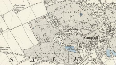
In 1871 George Bryan Cooke-Yarborough, George’s son aged 28, married Mary Parker, with his second child and eldest son, George Eustace, being born in 1876. George Bryan Cooke-Yarborough was resident at Campsmount on each of the census dates from 1881 to 1911. The OS maps of 1894 and 1907 (Figures 6 & 7) show little change to the landscape from 1849. The estate seemed to be maintained well, with features such as the kitchen garden, cedar walk, beech walks and rose garden showing in photographic evidence around the turn of the century. (Photos of: Beech walk looking east late 19th century (DA DZ MZ 62 ZA7); Beech Walk, from the east door of Campsmount early 20th century (DA DZ MZ 30/Z16); the front of Campsmount from the south (DA DZ MZ 30/Z8, Z9) Campsmount from across the lake (DA DZ MZ 30/ Z10, Z11).
It is from such photographic evidence that the maturity of features planned and executed in the mid-18th century can be seen. The sundial that Thomas Yarborough had erected in the new walled garden in the 1740s can be seen in a photograph looking north, showing the sundial in the foreground with a grass walk, surrounded by flower borders, leading to a large glasshouse (DA DZ MZ 62 ZA/7).
A photograph of the ‘cedar walk looking east’ (DA DZ MZ 30 Z15) shows mature cedars overhanging a gravel path, running to the east, which has a ha-ha to its south separating the path from a fenced enclosure which could be a tennis lawn. There are garden seats on both path and lawn. The corresponding picture of the ‘rose garden’ (DA DZ MZ 30 Z17), shows a formal rose garden in the foreground with the fenced lawn, ha-ha and gravel path of the cedar walk to the rear – and is taken looking west. These photographs suggest the location of the cedar walk and linked features being as shown on Figures 3 & 7.
George Bryan was sufficiently interested in the trees around Campsmount to write a letter in 1878 to the Journal of Forestry about eight cedars of Lebanon (DA DZ MZ 62 E16). He indicates the growth of these eight trees measured at intervals – 1826, 1831, 1839, 1847, 1855, 1861, 1876. For example, tree no.1 grew from girth of 9’7” in 1826 to 12’7” in 1876; tree no. 8 grew from girth 10’2” to 12’7” over the same period. George Bryan writes:
‘The trees were planted about 1730, growing on magnesium limestone, 100ft above sea level. They grow at the base of a steep bank 50ft in height on the top of which is an avenue of beeches about the same age as the cedars. They are well sheltered from the north by the bank and from the east and west by other trees, being fully exposed to the south. They are all of neat growth but I have no means of calculating their exact height. In some years seedlings come up from the cones which lie amongst the ..(?) and a fine mould is formed by the shedding of the needles. It is on record that in the hot summer of, I think, 1827 that the ground was covered in young plants. Some of these have been taken up and planted out but one in every ..(?) most miserable specimens.’
1915 onwards
At the age of 38 in 1914 George Eustace Cooke-Yarborough, George Bryan’s son, married Daphne Wrinch in Battle, Sussex. In 1919, after his father’s death in 1915, George Eustace attempted to sell off quite a bit of his outlying Campsall estate, as well as properties in Norton (DA DZ MZ 30 C1). However, he clearly retained Campsmount as his residence. In 1930 he made the decision to move to Wadsworth Hall and rented out Campsmount.
OS maps of 1930 and 1950 show remarkably little change in the main landscape features since the nineteenth century. After the demolition of Campsmount and the sale of the land, much of the parkland reverted to farmland. Much of the woodland remains as such, although containing few mature trees, as does the ‘new fishpond’. Most of the walls of the walled garden still stand, although its buildings and contents no longer remain.
Location
Campsall is situated 11.5km (7.5 miles) north of Doncaster.
Area
The former house, gardens, home farm and parkland covered 72.5 hectares (c.179 acres) (Figure 6).
Boundaries
The southern boundary lay along New Road and Bone Lane. The eastern boundary ran from SE 540 136 on Bone Lane north to SE 539 138, then running north of the High Street to the rear of the vicarage at SE 543 140, where a track ran a short way to the Church. From the vicarage, the boundary followed woodland edge north-west to SE 543 141, then parkland edge north-east to SE 543 142, west to SE 542 141 and north to SE 541 144. From here the northern boundary followed the curving edge of the parkland (and the parish boundary with Norton) to SE 543 145. The western boundary then followed parkland and field edges south to SE 535 143, south-west to SE 532 141, south to SE 533 138, west to SE 531 138 and south to join New Road at SE 531 137.
Landform
The site of Campsmount was at about 35m AOD, with the ground sloping down to the south to about 15m AOD by the lake. The parkland to the north and east sloped more gently towards about 15m AOD. To the north-west of Campsmount the land sloped gently upwards by just a few metres. Campsmount Park’s underlying geology is Bortherton Formation (limestone sedimentary bedrock) with freely draining lime-rich loamy soils with moderate fertility.
Setting
Campsmount Park lies in Doncaster Council’s Local Characterisation Area of C3 – Carcroft to Norton Limestone Plateau. This area is defined by its slightly raised elevation and the magnesium limestone geological deposits. This is a strongly rural area in which farmland predominates with mainly arable fields. The core of the village and the south-eastern part of the parkland are part of the Conservation Area.
Entrances and approaches
No lodges for Campsmount appear to exist on any maps.
One original trackway ran as an extension to the west of the High Street, to the immediate north of the five fishponds in Bull Close (and to the south of Brayton Hall) and circuited the west side of the walled garden to reach the north side of Campsmount. After the fishponds were enlarged this original road was truncated by the new pond. By 1849 carriageways ran to the north of the house through both the southern and northern parkland. By 1904 the carriageway through the northern parkland circled south to join the High Street near the T junction with Sutton Road. It is possible that there was a lodge here in the 1900s, since built over. A private road now exists running from SE 538 135 on New Road northwards to go between Campsmount Farm and the site of the house and exit through the northern park and woodland at SE 543 144 at a junction of three roads to the north of Campsall village.
In the 19th century there was a pedestrian entrance to the estate from the High Street (SE 543 139), leading to a wooded walk to the house. The remains of this entrance - gateway and flanking walls – are Grade II listed (HE 1314884), and are made of magnesian limestone with ashlar dressing. A central, round-headed, boarded door is set in square-headed ashlar surround flanked by projecting piers.
Principal Buildings
Brayton Hall
Dating from about the early 16th century, it was U-shaped in plan. It was demolished between about 1750 and 1790.
Campsmount
Campsmount was built between 1752 and 1756 to designs by Robert Carr and his son, John. It was demolished in 1959.
Campsmount: Home Farm
Campsmount farm, with multiple buildings, was built after Campsmount in the mid- to late-18th century to a plan by John Carr. Several of the original buildings survive and are Grade II listed. These include: Home Farm Cottages, originally one, now two dwellings (HE 1314883); Barn and cowhouse (HE 1192115); Cartshed and attached single-storey outbuilding (HE 1151461).
Bridge
John Carr designed a bridge over a gully for a trackway linking Campsmount to the Home Farm (DA DDCY 2 5). The structure is listed Grade II (HE 1192093):
Red brick arch, otherwise rubble limestone with ashlar sandstone dressings. Single-span basket arch; twin parapet walls with planting beds between. Arch has ashlar springers and alternately-raised, block-bonded brick voussoirs; band beneath coped outer parapet walls terminating at square end piers with domed caps; inner parapets line the farm track and curve to meet the end piers.
Summer House
A summer house of stone and brick was constructed in the 1730s on the ridge to the east of the site for Campsmount. It appears on most of the maps from 1794 (DA DZ MZ 30 P11) until the 1950s, after which it was demolished.
Gardens and pleasure grounds
It is likely that there were gardens around the original Brayton Hall, possibly in line with a plan drawn up by Joseph Perfect (DA DDCY 2 1) . However these disappeared when Brayton Hall was demolished in the late 18th century. The assumed location of Brayton Hall and gardens was thereafter referred to as ‘lawn’ or ‘old orchard’.
Formal gardens were associated with Campsmount including a rose garden which existed to the south-east of the house in the early 20th century. Details of records of formal gardens have not survived. Formal gardens were lost after the demolition of the house in the mid-20th century.
The pleasure grounds, including woodland walks, were first laid out by Thomas Yarborough in the 1730s. These included a beech walk on the ridge to the east of Campsmount and probably planted prior to its construction; a cedar walk to the foot of the slope to the south of Campsmount; a serpentine walk through trees down the slope to the south-east; a beech walk along the ridge to the vicarage and church. The woodland walks planted in the mid-18th century remain as wooded areas. A few of the cedars and a few of the beeches, on the ridge towards the church, survive.
Kitchen garden
A walled garden was constructed in early 1740s to the west of Brayton Hall and to the south-west of the site for Campsmount (Figures 2 and 3). The shape of the walled garden – like an inverted cone – probably reflected the sloping landform and existing trackways. Surviving records indicate extensive planting of fruit trees (see Historical Development of the site > Chronological history of the designed landscape > c.1718-c.1772). A sundial, erected in the centre of the garden at the time of its construction and shown clearly on the 1854 OS map survived into the 1940s. A building, probably a glasshouse, was erected against the north wall of the garden prior to 1847, with further buildings in the centre of the garden showing on the 1854 OS map. The original ‘wood room building’, to the south-eastern corner of the walled garden, appears to exist on the 1854 OS map. There is still a pond on the site of the original garden pond. Partially ruined walls of the garden survive. The garden contents were probably removed about the same time that Campsmount was demolished.
Park and plantations
The 1854 and later OS maps show the parkland as divided into North Park and South Park. The northern area was developed as parkland in the 18th century, while the southernmost area was laid out as parkland in the early 19th century when the ponds were enlarged and a new road made. Nearly all of the parkland is now farmland, with scattered trees and tree clumps having been removed.
North Park was the earliest part to develop as parkland and shows in a map of 1794 (DA DZ MZ 30 P11), to the north-east of Campsmount. In the 1740s this part of the parkland is called Long Mears Furlong (DA DZ MZ 30 P2). A circular copse of trees, surrounded by a circular pond, is shown on the 1794 map (Figure 2) and features on OS maps into the 20th century. The copse of trees survives. Outside the eastern edge of the North Park a plantation (Stony Hills Plantation, though named as Lodge Plantation on the 1854 OS map only) existed by 1794 (DA DZ MZ 30 P11). This plantation remained in existence until after the 1950s and has now been built over by housing.
At the time that Campsmount was constructed, the area to the south of the house comprised the walled garden, the old orchard (site of Brayton Hall), a trackway and a series of fishponds in Bull Close. When the fishponds were enlarged, between 1821 and 1847, to form one large pond containing a number of islands, the road past the fishponds was truncated. The South Park shows on OS maps as parkland from 1854 onwards and contains the walled garden and the ‘New Fish Pond’ with wooded areas between these two features. The South Park encompassed the land, including Bull Close, up to the new road. Areas of woodland remain between walled garden and pond and to the east of the pond. The south-easternmost part of the parkland has been built over for housing.
Water
A number of ponds existed at the time of the building of Campsmount, although the location of all of these is not certain.
A small pond was made in the southern part of the walled garden during its construction in the early 1740s. This pond still exists.
Five fish ponds in Bull Close existed from before 1794 until their enlargement between 1821 and 1847 into one large pond with five small islands with trees. This ‘new fish pond’ still exists.
A circular pond was constructed around a copse of trees in North Park by 1794. This pond still exists although it is overgrown.
Books and articles
- Collins, F. ed. 1887. Feet of Fines of the Tudor Period, Part 1. Worksop, Robert White.
- Dugdale, W. 1846. Monasticon anglicanum Volume 4. London, James Bohn. Collins
- Connor, T. 1975 The Building of Campsmount in The Yorkshire Archaeological Journal 47, 121-132
- Lawton, G. 1842. Collectio rerum ecclesiasticarum de dioecesi Eboracensi [Collections relative to Churches and Chapels in the Diocese of York] London, J. G. and F. Rivington.
Primary sources
Borthwick Institute for Archives (BIA)
- Abp Reg 23 - Archbishop Register, Thomas Rotherham 1480-1500
- YM/FD/10 - Inquisition post mortem of Edmund Yerburgh [Yarborough] of Balne Hall, 9 September 1631
- YM/D/CAMP/10 - Quitclaim 20 October 1547
Doncaster Archives (DA)
- DZ MZ 30/A4 - Account book 1700-1744
- DZ MZ 30/A5 - Account book 1719-1761
- DZ MZ 30/A6 - Account book 1720-1745
- DZ MZ 30/A7 - Account book 1730-1770
- DZ MZ 30/A17 - Account book 1859-1865
- DZ MZ 30/C1 - Auction sale catalogue 1919
- DZ MZ 30/P2 - A map of Campsall Fields 1720 Surveyor: Joseph Dickinson
- DZ MZ 30/P9 - A map of all the prospects from Hawkhill in the township of Campsall belonging to Thos. Yarborough 1742
- DZ MZ 30/P11 - Campsmount, plan of the park and adjoining fields 1794
- DZ MZ 30/P12 - Campsall township 1797
- DZ MZ 30/P21 - Campsall, Askern and Barnsdale early 19th cent
- DZ MZ 30/P23 - Campsall township 1827
- DZ MZ 30/S1 - A survey book of all the several farms belonging to Thomas Yarborough Esq in the lordship of Campsall in the West Riding of the County of York as the same are now regulated and settled 1739
- DZ MZ 30/S4 - Survey, titled on cover 'Campsall Rental' 1821
- DZ MZ 30/S5 - Survey 1826
- DZ MZ 30/S6 - Survey, titled 'Campsall Rental 1847' 1847-1849
- DZ MZ 30/S7 - Survey titled 'Reference to Campsmount Estate' 1851
- DZ MZ 30/S8 - Survey titled 'Reference to Campsmount Estate' 1859
- DZ MZ 30/S9 - Survey, titled 'Campsmount Rental' 1861
- DZ MZ 30/Z7 - Photo of Campsmount from the North-West
- DZ MZ 30/Z8 - Photo of Campsmount from the South
- DZ MZ 30/Z9 - Photo of Campsmount from the South, a more distant view than DZ MZ 30/Z8
- DZ MZ 30/Z10 - Photo of Campsmount from the South, a distant view across the lake
- DZ MZ 30/Z11 - Photo of Campsmount from the South, across the lake, a slightly closer view than DZ MZ 30/Z10
- DZ MZ 30/Z15 - Photo of Cedar Walk, looking east
- DZ MZ 30/Z16 - Photo of Beech Walk, from the east door of Campsmount
- DZ MZ 30/Z17 - Photo of Rose garden, looking west
- DZ MZ 30/Z18 - Photo of Summer house, with Violet Cooke-Yarborough
- DZ MZ 62/E16 - Letter from George Bryan Cooke-Yarborough to the Journal of Forestry 1878
- DZ MZ 62/W32 - Copy of a royal grant dated 22 June 1294 17th century (copy)
- DZ MZ 62/ZA3 - Photograph of the Kings XIV Hussars Includes George Bryan Cooke-Yarborough standing in the centre 1866
- DZ MZ 6A/ZA7 - 24 contact prints including: Campsmount kitchen garden looking north (Early 20th century); Alice Cooke-Yarborough outside the summer house at Campsmount (Early 20th century); Campsmount Beech walk looking east from the roof (Late 19th century); Campsmount Beech walk looking east from the east door; Campsmount looking from the north of the house towards the Home Farm (Late 19th century)
- DDCY 2/1 - Mid 18 century Plan of the pleasure grounds
- DDCY 2/2 - Mid 18 century Plan of plantation and paths
- DDCY 2/3 - Early 19 century Plan of fields around Campsmount
- DDCY 2/4-10 - Plans for Campsmount Home Farm
- DDCY 2/4 - 18 century Ground plan of new stables and other farm buildings
- DDCY 2/5 - 18 century Plan and elevation of the bridge
- DDCY 2/6 - 18 century Elevation of the east side of the carthouse, stable, corn barns, cow house, oxhouse and haybarn
- DDCY 2/7 - 18th century Elevation of the west side
- DDCY 2/8 - 18th century Elevation of the farmhouse and poultry sheds
- DDCY 2/9 - 18 century East elevation of stables and coach house
- DDCY 2/10 - 18 century Elevation of the carpenter's workhouse, board room and pigeon chamber
- DDCY 2/ 11-27 - Plans for Campsmount
- DDCY 2/11 - 1802 Elevation of the north front 'in its present state'
- DDCY 2/12 - 1802 Elevation of the north front with improvements
- DDCY 2/13 - 1802 Elevation of the north front with improvements
- DDCY 2/14 - 1802 Design as DDCY/2/13 outline drawing, uncoloured
- DDCY 2/15 - 1802 Elevation of the north front with improvements
- DDCY 2/16 - 1802 Elevation of the south front with improvements
- DDCY 2/17 - 1802 Elevation of the south front with improvements
- DDCY 2/18 - 1802 Elevation of the south front with improvements
- DDCY 2/19 - 1802 Elevation of the east front 'No. 2'
- DDCY 2/20 - 1802 Elevations of the east front 'No.1'
- DDCY 2/21 - 1802 Elevation of the west front 'with the roof of the wings raised so as to admit of three stories'
- DDCY 2/22 - 1802 Plan of the ground floor 'in its present state'
- DDCY 2/23 - 1802 Plan of ground floor with proposed improvements
- DDCY 2/24 - 1802 Plan of the chamber storey with improvements
- DDCY 2/25 - 1802 Plan of the attic storey over the house and offices
- DDCY 2/26 - 1802 Section of the window side of the drawing room 'in its present state'
- DDCY 2/27 - 1802 Section of the window side of the drawing room 'with the manner of forming the sashes, window shutters in the modern style'
- DDCY 2/33 - 1802 A plan of the desmesne lands at Campsmount the seat of Geo. Cooke Yarborough Esq. with some alterations by John Webb
- PR NOR/4/1 - Campsall, Askern and Norton: enclosure award (with map) 1818
North Yorkshire County Record Office (NYCRO)
- ZDU[18]42 - Jeffrey’s map of Yorkshire c. 1771, Plate 18
Sheffield Archives (SA)
- BFM/956/6 - Mr. Currer's survey of the Manor of Campsall. n.d. [c. 1605 – 1610]
Maps
- Ordnance Survey 1st edition 6”, surveyed 1849, published 1854
- Ordnance Survey Rev edition 6”, surveyed 1891, published 1894
- Ordnance Survey 1st edition 25”, surveyed 1891, published 1893
- Ordnance Survey rev edition 6”, surveyed 1904, published 1907
- Ordnance Survey Rev edition 25”, surveyed 1904, published 1906
Figure 1 - Mid 18th century Plan of the pleasure grounds – annotated to show garden features. Reproduced by permission of the Cooke-Yarborough archive
Figure 2 - Campsmount, plan of the park and adjoining fields 1794 Reproduced by permission of the Cooke-Yarborough archive.
Figure 3 - OS 6” map, surveyed 1849, published 1854 annotated to show features of the 18th century landscape. Reproduced by permission of the National Library of Scotland.
Figure 4 - OS 6” map, surveyed 1849, published 1854 annotated to show features of Webb’s plan for George Cooke-Yarborough. Reproduced by permission of the National Library of Scotland
Figure 5 - OS 6” map, surveyed 1849, published 1854 showing mid-19th century landscape. Reproduced by permission of the National Library of Scotland.
Figure 6 - Campsmount Park OS 6” map, surveyed 1891, published 1894. Reproduced by permission of the National Library of Scotland.
Figure 7 – Detail of garden and pleasure ground OS 25” map, surveyed 1904, published 1906. Reproduced by permission of the National Library of Scotland.


