The Monk Fryston estate goes back to at least the early 14th century when it belonged to Selby Abbey and served as a quarrying and farming site. The current park and garden was developed in the second half of the 19th century by the Hemsworth family. The Italianate garden, extensive network of ponds and boating lake, woodlands, maze, menagerie, concert rooms and sports grounds were more typical of a late Victorian public park, however this was privately owned by the Rev. Benjamin and Constance Hemsworth. Their strong Christian beliefs and philanthropy meant they used their estate to host numerous social and sporting events including the annual Agricultural Show and Gala.
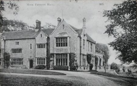
The building of railway stations at Monk Fryston and Milford Junction and later bus services from nearby towns brought many visitors, always by invitation only. These events were widely reported in the local press and the local shop sold postcard views of the Hall and its gardens (Figure 1). The estate, as part of Monk Fryston Hall Hotel, remains an important part of the village and its Conservation Area.
Estate owners
Friston Manor was gifted to the Benedictine Monastery of Selby in 1080 by the Archbishop of York, Thomas of Bayeux, and owned by them until the dissolution of the monastery in 1538. During this period the ‘Great Hall of Stone’ (Monk Fryston Hall) was occupied by the Master of the Works and the Agent of the Abbot (BL Add MS 36579). After the break-up of Selby monastery, the fate of the Fryston Manor quarries, granges and Hall are not documented but seem to have passed through several ownerships until 1680 when David Hemsworth, residing in nearby Birkin, bought the Hall and Manor.
David Hemworth’s descendant (also David, 1710 – 1788) made some alterations to the Hall but his son Benjamin (1747 – 1819) decided to build a new family residence nearby (now known as Monk Fryston Lodge). On his son, David’s, marriage in 1798, David senior gave the couple the new house and moved back to the Hall until his death. It was David’s younger son, Benjamin (1816 – 1886) who was the next resident from the family to live at the Hall from 1842. On his death, it was inherited by his son, the Rev. Benjamin (1848 – 1923). His wife, Mary Constance (née Duke) continued to live at the Hall until her death in 1940, although the estate had been left to her nephew.
The Monk Fryston estate was finally put up for sale in 1946. The following year it was converted to a Hotel by Mr. S. W. Tinsdale and remains so after several changes of ownership.
Key owners responsible for the development of the designed landscape and the dates of their involvement:
Benjamin Hemsworth senior (1842 – 1886)
Rev Benjamin Hemsworth junior (1886 – 1923)
Mary Constance Hemsworth (1894 – 1940)
Early history of the site
‘Friston’ Manor dates to Saxon times and the settlement that later became known as Monk Fryston had a stone church. It was given to Selby Abbey to supply stone and other materials for the building of the new abbey and to supply farm produce for it. During the 458 years of Benedictine ownership the lands around the centre of the village were extensively exploited to quarry the local stone, to make roads and to create waterways to transport these materials to the abbey complex 8 miles away in Selby using local springs, tidal surges and dykes (Cawthorne 2013, 65-6 and Newton 2011). The quarries were worked by lay brothers, but as the Abbot owned the manor of Fryston the village came to be known as Monk Fryston during the mid-14th century.
The medieval Hall was occupied by the Agent and the Master of Works to oversee the quarrying. A survey of the extent of the ‘Manor of Friston’ commissioned by Edward II in 1320 (BM Add MS 36579) lists ‘a great hall of stone, with stable, large barn, granary and dovecote’, it also mentions windmills, watermills and a fulling mill. No mention is made of the grounds, so we cannot know if the later areas of water were previously medieval fish ponds. The site of the present Hall is on the medieval footprint even though the building has undergone many reconstructions and extensions over the past 700 years. Traces of a medieval Hall, a chapel and a solar were identified by Pevsner (1959, 372) and are partially visible today in the southwest corner of the original south façade. The watercourses for the harvesting and management of the spring waters on the site were clearly a resource valued by the monks.
Following Hemsworth’s purchase of the estate, the Hall was known as Old Hall Farm and the family probably continued to live in nearby Birkin. The nearby Monk Fryston Park (also known as Monk Fryston Lodge) became the preferred seat of the Hemsworth Family once there was wealth enough to construct a new residence in the late 18th century. This was built outside the main village on higher ground to the west of the village centre and away from the public gaze of the main thoroughfare, the Halifax to Selby Turnpike constructed in 1740.
Around 1740, the ‘Old Hall Farm’ was renovated by David Hemsworth, with a large part of the building being pulled down, so by the time of his marriage to Sarah Hanson in 1740, it was habitable again. The 1793 Enclosure plan for the village (Figure 2) showed the Hall set in the middle of open grounds opposite the parish church, with the ‘great barn’ in situ. It was surrounded by small village tofts [plots of land with building] and roadside buildings on the turnpike road. Between 1819 and 1842, the Hall was not occupied by the family and was used only as a farm.
Chronological history of the designed landscape
In 1842 Benjamin Hemsworth married the local heiress Sarah Bower and they started large scale renovations to the building and the construction of new gardens. The 1st edition 6” OS map, surveyed between 1845 and 1848 (Figure 3), showed the changes made to the landscape. There was a new carriage drive and circle and two ponds, one to the east and another to the south. The drive entrance off the public road was due south of the Hall. To the north of the ‘great barn’ there may have been an orchard. Hemsworth seemed to have been a keen plantsman, particularly for tender plants such as pelargoniums, begonias and fuchsias, as he won awards for these at local flower shows (York Herald, 21 June 1862; 13 June 1863; 18 June 1864). These were presumably grown in the greenhouse that was large enough to hold a bazaar in 1888 (York Herald, 29 November) and is shown on the 1st edition 25” OS map, surveyed in 1890 (Figure 4).
By 1890 (Figure 4), there was a new entrance with a lodge to the south east of the Hall. In the pleasure grounds to the north of the new carriageway was an aviary. To the north of the Hall there were new terraced gardens with fountains and paths that led from the House down to the new ‘Fishpond’ with its islands and straight extension or canal to Fryston Common Lane. An extensive kitchen garden had been built with glasshouses and high walls to the north and west sides. Trees had been planted along the new perimeter walls of Main Street, Fryston Common Lane and the field boundaries. The woodland area to the north had been developed and the adjacent large field had been opened up to create an area of parkland. There was a new footpath north towards Milford Junction Station.
In 1894 the Reverend Benjamin Hemsworth married Mary Constance Duke. They started further extensive building renovations and in 1897, the house was enlarged to designs by architect Sir Ernest George. This included a large raised terrace to the east and north side. George had worked with fellow architect and garden designer Harold Peto but their professional partnership ended in 1892. No evidence has been found to link the design with any individual, however the Visitors’ Book (MFTTA Visitor Book) records Harold Peto staying at the Hall in October 1896. Later entries record visits by his sisters Emily and Ruth Peto, so the connection may have been purely social.
One possibility is that it was Mary Hemsworth who designed the grounds. Her maternal family lived at Ven House in Somerset and she grew up at Lake House in Wiltshire, both of which had noted formal gardens contemporary with their buildings (Figures 5 & 6). She was an accomplished artist and painted large murals of ‘Bonnie Scotland’ in the nearby quarry that had been turned into a pleasure ground (Figure 7) and Alpine and Italian murals in the Concert Halls on the estate. She also painted scenes from Coleridge’s ‘The Rime of the Ancient Mariner’ on the Lucerne Bridge crossing one of the lakes (Figure 8).
By 1906 (Figure 9), the designed landscape was complete. The main changes were the extension of the Fish Pond north into the woodland where a series of ponds were created. In the woodland next to the new ‘Deer Park’ was a maze. On the extreme western edge of the Fish Pond, a boathouse had been erected and in the pleasure grounds, another aviary. In the open area on the eastern edge of the estate, next to Fryston Common Lane, sporting pitches were laid out, together with a pavilion. These grounds, together with the private zoo of birds and animals, became the setting for an annual calendar of Christian social and sporting events hosted in the Concert Rooms and in the parkland.
There were visits by missionary societies, Mothers Union outings, Sunday School treats, bazaars for the Girls Friendly Society, a Venetian Fête on the Boating Lake in 1906 and sporting events such as cricket and hockey club matches. Musical events including musical theatre and choral competitions were hosted in the Concert Rooms. Mrs Hemsworth’s sister was a keen photographer and there is a good collection of images probably taken by her of some of these events. There are also many newspaper records from the Pontefract Advertiser covering this period.
A report from 1912, gives a flavour of these occasions and the grounds:
‘Monk Fryston Hall is a stately and very picturesque mansion standing in an extensive and richly-wooded park…The Squire’s collection of birds and beasts is worth travelling a long way to see…The chief attraction of the park, and one that each year is greatly appreciated by thousands of visitors, is a lake. It is…a long, meandering, beautiful lake, in places no wider than a small river, and in others broadening out to admit…bathing…Here and there perfect little islands adorn its surface, and at frequent intervals, it is spanned by graceful bridges of woodwork…Here it skirts the verdant pastures of the park, now it shimmers below a quaint rustic summer-house, presently it leads into the heart of a thick, flower-carpeted wood…The handsome bridge across it is a replica of the famous painted bridge at Lucerne…Boating is permitted on the lake, and nearby there is a capital cricket pitch with a rustic thatched pavilion…Another feature is the maze…At the other side of the park, nearer to the hall, there is a swimming bath...“Bonnie Scotland” Over against the deer park there is what apparently at one time was a quarry-now it is an orchard, and at the far end Mrs. Hemsworth has painted a remarkably realistic scene of a Scotch mountain ravine, with a group of mountains in the background…In the orchard there is another lake, a miniature one with a waterfall so arranged that it can be turned on and off at will. In short, Mr. and Mrs. Hemsworth have succeeded eminently in beautifying a naturally beautiful park, not merely for their own satisfaction and pleasure, but that they might minister to the enjoyment of others’ (Yorkshire Evening Post, 14 August).
Later history
The First World War brought all these activities to an end as the Visitor’s Book records in March 1917 (MFTTA, 90) ‘we have parted with all the indoor servants and started doing all the work of the house ourselves’. The head and assistant gardener, the groom and the butler were all conscripted in 1916. In 1923 Benjamin Hemsworth died and death duties force further economies onto the estate. The collection of birds and animals from the private zoo was transferred to Temple Newsam, which had been sold to Leeds Corporation in 1922. Between 1923 and 1939, the gardens and concert halls continued to be open to invited groups of visitors but on a much reduced scale. The Hockey and Cricket Clubs continued their games until the outbreak of war in 1939.
In 1940 Constance Mary Hemsworth died and the estate passed to a nephew who was killed in the war. The War Office took control of the Hall and grounds and used it for officer training. The Hall’s gardens and parkland were kept as a restricted access area from which villagers were excluded. In 1946, the estate was put up for sale and the grounds were described in the sale catalogue (ERA DDCL 3311):
‘The Manor House, Pleasure Grounds, Woodland and Park of Monk Fryston
In a sheltered position in the village of Monk Fryston standing back from the main road and sheltered by mature trees and shrubberies. A sweeping drive leads through timbered grounds to the Manor…
The Formal Gardens are designed after the style of Le Notre in grass terraces with formal flower beds and central fountain. Regular paths lead down to the side of the large lake in the pleasure grounds. There is an aviary adjoining this garden.
The Kitchen Gardens are sheltered from the Flower Gardens by yew hedges. They are well stocked and productive and are sheltered by good walls with a Southern exposure.
There are two large Nurseries, Fern House, two Peach Houses, Potting Shed, Mushroom House and other glass which is in good condition.
The Pleasure Grounds. Beyond the Formal Gardens, the old monks’ fish pond has been made into a large natural lake, and a boathouse at the bottom of the gardens gives access onto this water. The lake runs through natural woodlands and is a most delightful feature of the property. At one point a timbered bridge has been built over the water, an exact replica of the one at Lucerne.
The Woodlands form the Eastern boundary of the Park, which extends to some 71 acres, at the North and West of the House’.
After the purchase and conversion to a hotel, some of the estate lands have been sold for housing development including parts of the Deer Park adjacent to Lumby Lane, the former Alpine Hall and Concert Rooms and the former cricket and hockey field.
Location
Monk Fryston is situated 7 miles west of Selby and 8 miles northeast of Pontefract. It lies 2 miles east of the A1 (M) motorway and 4 miles north of the M62 motorway. The A63 Leeds to Selby road passes through the centre of the village.
Area
The historic estate covered 31 hectares (77 acres) (Figure 10).
Boundaries
The southern boundary to the east is formed by the main A63 Leeds to Selby road from the entrance opposite the church to the junction with Fryston Common Lane and continues along the lane to the edge of the eastern shelter belt. The boundary on the east follows the shelter belt north to Ingthorns Lane that forms the boundary to the woodland on the northernmost edge. The western boundary follows the edge of the Deer Park and southern parkland to Lumby Lane. The southern boundary to the west follows Lumby Lane until the junction with the A63.
Landform
The site is low lying at 10 metres AOD on the edge of the Vale of York. However, the underlying bedrock of Permian Magnesian Limestone lies close to the surface on the western side of the site and this has been quarried for centuries. The overlying drift geology deposits of glaciolacustrine clays and glaciofluvial sand and gravel with peat are typical of the wider Humberhead Levels landscape character area and this is evident on the south eastern side of the site.
Setting
Monk Fryston Hall is situated in the centre of Monk Fryston and much of the site lies within a Conservation Area (http://www.selby.gov.uk/sites/default/files/Documents/Monk_Fryston_Conservation_Area.pdf.)
The Hall and its Lodge House entrance form a distinctive roadside boundary and together with the backdrop of mature trees and wide open spaces they contribute a strong character setting to the heart of the village.
Entrances and approaches
Gates, gate piers, railings and wall at entrance to Monk Fryston Hall (Listed Grade II, NHLE 1167717)
Stone boundary wall, gate piers and railings, mid to late 19th century
Lodge to Monk Fryston Hall (Listed Grade II, NHLE 1316270)
Stone built Lodge House mid to late 19th century
Pedestrian access leading directly from the Church to the Hall.
Stone Piers and steps onto Main Street opposite St Wilfrid’s Church.
Vehicular access off Fryston Common Lane near the Sports Ground via stone pillars and (modern) timber gates.
Vehicular access onto Main Street (opposite the Crown Inn car park) directly from the Coach House, Stables and Concert Halls.
This is currently gated as there is no right of way.
Former footpath access (now expired) from the Hall across Deer Park to the former railway station at Milford Junction.
Principal buildings
Monk Fryston Hall (Listed Grade II*, NHLE 1148544)
The Hall, now a hotel, has 13th century origins and was built for Selby Abbey with additions and alterations of c. 1740 for David Hemsworth. The additions of 1897 by Sir Ernest George were a ballroom, billiard room and staircase. There was a further 20th century range to the left. Constructed of Magnesian limestone with stone slate roof.
The Coach House
Dating from late 19th century, converted to offices in 1989.
Stable Block
Dating from late 19th century.
The Boat House
It dates from between 1890 and 1906. Although labelled as a ‘boat house’ on the OS maps, this was not a freestanding structure but consisted of an archway under the north wall of the kitchen garden with access perhaps from the garden side through the greenhouse.
Summerhouse
A small circular, stone built structure, it was a focal point at the end of the promenade path that ran along the wall side adjacent to Fryston Common Lane where many of the zoo animals were housed. It dates from 1850 to 1890. This path continued along the canal and also crossed into the sports ground. The last stones from the Summer House were used after the war to repair parts of the Hall roof (Figure 11).
The Aviaries
Two aviary buildings are shown on the OS 1908 25 inch map. Only the larger brick built aviary still stands and its former thatched roof has been replaced with slate roofing (Figure 12). When the zoo existed there were numerous aviaries and cages lining the promenade paths, in the pleasure grounds southeast of the Hall, to house the collections of exotic birds and animals.
Lucerne Bridge
Dating from between 1890 and 1906, its design by Sir Ernest George, is based on the covered wooden bridge over Lake Lucerne, Switzerland; under the roof are 18 paintings by Mrs. Hemsworth depicting scenes from Coleridge’s ‘The Rime of the Ancient Mariner’ (Figure 8).
Indoor Swimming Pool
Glazed pool next to the glasshouse complex, this was therefore probably heated.
Concert Rooms
Complex of Alpine Hall, Italian Hall and Concert Hall, situated to the north west of the Hall (Figure 9). Mrs. Hemsworth painted Alpine and Italian murals in them. Now demolished.
Gardens and pleasure grounds
The Italianate garden had level lawns with ornamental flowerbeds and two fountains leading to the boating lake with four Coadestone lion statues lining the steps (Figure 1). Only one fountain is still operative with its raised stone pool. This garden was laid out in the period between 1850 and 1890.
The raised terrace has stone balustrading and two flights of steps down to the east lawn and stone steps leading north to the Italianate garden. This terrace led out from the extension designed by Sir Ernest George in 1897 and it is assumed to be part of his design.
In the woodland garden was the Maze, which was rectangular in form. It is no longer extant but is depicted on the OS 25” map surveyed in 1906 (Figure 9). It was situated on the west side of the woodland on the edge of the Deer Park.
The Sports Ground lay beyond the canal and was reached by footbridges from the gardens and by a gate directly off Fryston Common Lane. Its pavilion had a thatched roof (Figure 13).
Kitchen garden
The Kitchen Garden with its heated glasshouses and walls probably dates from the 1850s. From 1861 to 1874 there are newspaper reports of prizes awarded to Benjamin Hemsworth for fuchsias, pelargoniums, chrysanthemums, strawberries, and ferns. Just over one acre in area, it had high walls to two sides with another side garden to the west. Figures 14 and 15 shows some of the glasshouses still extant in the late 1950s/early 60s. The 1946 Estate Sale catalogue records two Nurseries, a Fern House, two Peach Houses, a Mushroom House and Potting Shed.
Park and plantations
Deer Park
The Deer Park was laid out by the last estate owners, the Rev. B. and Mrs. Hemsworth. The perimeter tree planting to the Deer Park along the north and west boundaries was established sometime between the OS maps, surveyed in 1890 and 1906. They also laid out the footpaths giving access to the Concert Rooms and the quarry garden known as ‘Bonnie Scotland’. The access path to Milford Junction station was already established by his father as it was operational from 1840.
Plantations
The largest plantation of sycamore, horse chestnut and poplar trees is in the north east corner of the parkland and was planted in the period between 1850 and 1890. During the same period perimeter tree planting was established to all the main parkland boundaries and along the main canal stretching from the Boat House at the back of the walled kitchen garden to Fryston Common Lane.
The 1890 25” OS map (Figure 4) shows a complex of wooded mounds 5 to 8 metres high between the south front of the Hall and the roadside boundary wall. They may originate from material removed to form the first Boating Lake and Canal which appear when the main gardens to the north of the Hall were laid out between 1850 and 1890. These mounds may have been added to later when the boating lakes and canals were extended into the woodland plantation by the Rev. and Mrs. Hemsworth and which are seen on the 1908 OS map. The mounds may also have been started to accommodate roadway excavations to improve the gradient of the Turnpike which lies parallel to the original road running past the Church with its steeper gradient. Competition from the new railways to speed traffic along this route through the village also led to the creation of the S-bend in Monk Fryston Square when two T-junctions were removed from this location.
Water
Fish Pond
The first ‘Fish Pond’ with its two islands, four footbridges and perimeter footpaths was laid out in the period 1850 to 1890 and followed a natural depression in the land fed by natural springs which are plentiful in this part of the village. The second more extensive phase of water features are shown on the 1908 OS map and were created as boating lakes, although they are designated ‘Fish Pond’ by the Ordnance Survey maps. The main boating lake, to the north of the Hall, has a stone parapet and steps for embarking onto the punts (Figure 16). Four Coadestone greyhound statues line the steps. It is spring-fed and extended by canal to the Fryston Common Lane boundary (Figure 17).
The areas of water continue northwards from the first Fish Pond into the woodlands to become a continuous stretch of water featuring five islands, two canals and thirteen footbridges including the ‘Lucerne Bridge’ (see Section 4.7.7). The canal from Lucerne Bridge to Fryston Common Lane is now overgrown but features an island along the route. The canal once had an outlet onto the stream the other side of the lane but the watercourse has been diverted into the roadside channel.
Outdoor Swimming Pool
At the northeast corner of the lake complex is a squared-off pool said to be used for swimming.
Books and articles
Pevsner, N. 1959 The Buildings of England – Yorkshire West Riding. London, Penguin.
Cawthorne R. 2013. The Monastic Lands of Selby Abbey - A Landscape Archaeology Study. Unpublished dissertation for BA, University of Hull Deptartment of History.
Newton R. 2011. The Search for Monk Fryston Canal. Unpublished research by Monk Fryston Time Team.
Primary sources
British Library
Add MS 36579.f.8 Monk Fryston Manor extent, 1320
East Riding Archives (ERA)
DDCL 3311 Sale catalogue for Monk Fryston estate, 1946
Monk Fryston Time Team Archive (MFTTA)
[For further details see their website - http://www.findingfryston.co.uk/]
Monk Fryston Hall Hotel, Aerial Photograph c. 1960
A Handy Book for the use of Visitors to Monk Fryston Hall Containing a Catalogue of the Zoo, a short History of the Hall and Numerous Views (n.d. c. 1910) by kind permission of Mr D. Bramley
Visitors Book, Monk Fryston Hall 1894 – 1940 by kind permission of Mr D. Bramley
Postcard Views of Monk Fryston c. 1910
North Yorkshire County Record Office (NYCRO)
WRRD B 19 Enclosure Map of Monk Fryston, 1793
Newspapers & Magazines
York Herald
Yorkshire Evening Post
Maps
Ordnance Survey 6” 1st edition, surveyed 1845 to 1848, published 1850
Ordnance Survey 25” 1st edition, revised 1890, published 1892
Ordnance Survey 25” 2nd edition, revised 1906, published 1908
Figure 1 - Postcard Views of Monk Fryston c. 1910. Reproduced by permission of Monk Fryston Time Team Archive (MFTTA)
Figure 2 - 1793 Enclosure Plan of Monk Fryston, extract showing Hall and surrounding area. Source: North Yorkshire County Record Office (WRRD B 19)
Figure 3 – 1st edition 6” OS map, surveyed between 1845 and 1848, showing Monk Fryston Hall, Great Barn, new carriage route and ponds. Reproduced by permission of the National Library of Scotland.
Figure 4 – 1st edition 25” OS map, surveyed in 1890 showing pleasure grounds, new Fishpond, kitchen garden complex, woodland to the north. Reproduced by permission of the National Library of Scotland.
Figure 5 - Ven House Somerset, the home of Mrs. Hemsworth’s grandfather. Reproduced by permission of MFTTA
Figure 6 - Lake House Wiltshire, the childhood home of Mrs. Hemsworth (née Duke). Reproduced by permission of MFTTA.
Figure 7 – ‘Bonnie Scotland’. Image reproduced by permission of MFTTA.
Figure 8 - The Lucerne Bridge with one of the 18 scenes of ‘The Ancient Mariner’ painted by Mrs. Hemsworth. Images © Susan Newton.
Figure 9 – Revised edition 25” OS map, surveyed in 1906 showing extension of the Fishpond, extended woodland planting, maze, Deer Park, Concert Halls, ‘Bonnie Scotland’ and sports ground and pavilion. Reproduced by permission of the National Library of Scotland.
Figure 10 – Revised edition 6” OS map, surveyed in 1906 showing extent of designed landscape. Reproduced by permission of the National Library of Scotland.
Figure 11 - Mixed Hockey on the Lawn looking towards Fryston Common Lane and the Summerhouse. Reproduced by permission of MFTTA.
Figure 12 - Thatched Aviary, before reroofing in slate and removal of porch. Reproduced by permission of MFTTA.
Figure 13 - Sports Pitch with Thatched Pavilion. Reproduced by permission of MFTTA.
Figure 14 - Aerial photograph of Kitchen Garden and Glasshouses in 1950s. Reproduced by permission of MFTTA.
Figure 15 - Aerial photograph of Kitchen Garden and Glasshouses c. 1960. Reproduced by permission of MFTTA.
Figure 16 - Boating Lake, one of a series that ran through the woodlands. Reproduced by permission of MFTTA.
Figure 17 - Boating Canal, one of two canals that connected the Boating Lakes. Reproduced by permission of MFTTA.
The following images were offered to YGT in July 2020 and are reproduced here by kind permission of Christine Beevers:
Figure 18 - Architects Sketch of Covered bridge 1899
Figure 19 - View of East side of the Hall showing the extension by Ernest George
Figure 20 - View of South side of the Hall with the Reverend ‘Benny’ Hemsworth
Figure 21 - View of Deer in the Deer Park
Figure 22 - The landing stage Rose Walk and bridge to one of the Islands
Figure 23 - View of Boating Lake, the former ‘Monks Fish Ponds’ with island bridge and Woods
Figure 24 - View of the woodland waterway and bridge
Figure 25 - View of Flowerbeds and Fountains from the main Terrace looking towards the Landing Stage for boats with the woods and Deer Park beyond


.")


