The designed landscape of Barrowby Hall estate near Garforth, Leeds was largely laid out for Arthur Ingram in the 1720s, possibly to designs by William Etty who remodelled the hall. Ingram’s family owned the neighbouring Temple Newsam estate, where Etty also worked at the time. After Ingram’s death in 1742, it was a secondary property for his heirs and rented out, which meant that this early layout was little altered as landscape fashions changed over the following century. Although the urban centre of Leeds to the west and, most recently, the A1-M1 link route now have encroached on its perimeter, the hall and its associated historic designed landscape remains legible today.
Estate owners
In the sixteenth and seventeenth centuries, the land was occupied (and probably owned) by the Layton family. By 1674, it had been bought by Arthur Ingram Esq., a younger son of Sir Arthur Ingram of Temple Newsam. When Arthur Ingram died in 1713, it was Arthur, his second son, who inherited Barrowby. Arthur Ingram junior died in 1742 and his estates at Barrowby and Rudby in Cleveland passed in trust to his only child, Isabella, and her daughters. Isabella had married General George Cary in 1738 and the couple purchased Leven Grove, Rudby (Skutterskelfe Park entry on database), which they made their main home from 1754.
By 1772, Barrowby was leased to George Lloyd, as he gave a paper to the Royal Society about the rainfall recorded there between 1772 and 1777 (RSA L&P/7/23). Lloyd died at Barrowby in 1783 and by 1791, Charles Smith was recorded as living there (Sheffield Public Advertiser, 30 September). Following a court case in 1803 where Lady Amherst (née Cary) was the plaintiff and Charles Smith one of the defendants (TNA C 13/24/16), the estate was put up for sale two years later (The York Herald, 2 November 1805). It would appear though that Smith bought it as it was withdrawn from its proposed sale on the 20 November (Leeds Intelligencer, 18 November). In 1812, Smith advertised the estate for sale (Leeds Intelligencer, 13 April) and it was sold to Richard Oliver Gascoigne of Parlington Hall before February 1813, although Smith continued to live there until 1822 as Gascoigne’s tenant (Barnewall et al. 1822, 89).
After Gascoigne died in 1843, his estates were left to his two daughters and Barrowby continued to be occupied by tenants. William Simpson Atkinson was the tenant from c. 1835 until his death in 1886. The Gascoigne family continued to own the estate until 1937 until it was sold to John Green, a timber merchant. By 1960, when it was put up for sale again, it was described as ‘Barrowby Hall Farm’ (HEA SA01938) and remains privately owned.
Key owners or tenants responsible for major developments of the designed landscape and dates of their involvement:
Arthur Ingram Esq. senior c. 1674 – 1713
Arthur Ingram junior [‘Turkey Merchant’] 1713 – 1742
Charles Smith c. 1791 – c.1812
Richard Oliver Gascoigne c. 1816 – 1843
William Atkinson c. 1835 – 1886
Mary Isabella Trench (née Gascoigne) 1843 – 1892
Chronological history of the designed landscape
In 1523, John Dounings and George Laton are recorded as holding a messuage with appurtenants in Barrowby, with the property being occupied by Laton (Thoresby Society 1935, 74). This was possibly the building occupied by Gabriel Layton, George’s descendant, in 1672 that had 6 hearths (http://gams.uni-graz.at/o:htx.WR4#h_4, accessed 29 July 2022). The rear north elevation of the current Hall bears the date 1677, which was two years after Arthur Ingram’s marriage to Jane Mallory but it is not clear if the date stone marks a new build or an additional wing to the Layton’s house.
When Arthur Ingram junior inherited Barrowby, he had probably accumulated some wealth and reputation through his trading in the Levant, so started on a series of improvements between 1718 and 1720. Work on the house was put into the hands of William Etty of York (c. 1675–1734). Etty is known primarily as a carpenter, carver, clerk of works, and architect. He designed the Moot Hall and Holy Trinity Church in Leeds, and worked at Whixley Hall, Baldersby Park, Brocklesby Park, Seaton Delaval, Castle Howard, Studley Royal (at the ‘Greenhouse’) and Aldby Park. He is proposed as the architect of Eglingham Hall in Northumberland, which looks very similar to Barrowby.
Etty is also known for his involvement in laying out landscapes elsewhere. He acted as Clerk of Works at Castle Howard, and was responsible for building (1711–15) the bridge and gate into Wray Wood (Jeffreys 2018, 47). In 1727, he sent George Bowes designs for a ‘House Stables and Principall Court and Avennew as allsoe the Out Lines of the Wall and Bastions’ – probably for Gibside, but drawings now lost. At Temple Newsam, he laid out the east avenue with bridges, cascades, and fishponds (1710–15), said to have cost £850, for the 4th Viscount Irwin (Colvin 1978, 301). It was no doubt through family connections that he was commissioned in 1718 to work for the cadet branch of the Ingrams at Barrowby, viz. to build a fashionable and fit-for-purpose house (ibid) and, possibly, to ‘improve’ the gardens and park.
There are no references in Etty’s letters to plans for the gardens and park and no payments made to him specifying work on the gardens have, so far, been found. However, in May 1719 Thomas Richardson received from Arthur Ingram £100 for ‘repairing or Making his Gardings att Barraby’ (WYASL WYL100/F/15). This was not an inconsiderable sum (as a very rough guide, approx. £12,000 today). Searches have found no further records for a gardener (at this period) named Thomas Richardson, but what is interesting is that the work specified not just ‘Making’ but ‘repairing’ the gardens, strongly suggesting that some existing features were retained. Other than this, there are just a few vouchers and bills (ibid) that itemise deals for ‘Garden fraimes’; and painting of ‘pallisaid gate next pond’ and ‘gate at end of long walks’ (thus perhaps allowing an extended view out into the park). A single further reference to the gardens comes from Arthur’s daughter, Isabella (born January 1719/20), commemorating the loss of her pet squirrel, Bunne, on a stone slab: ‘Here lyeth a favorite Squirril of Isabella Ingram, who dyed – of Feb 1729’.
Barrowby ceased to be the seat of the Ingram family when Arthur died in 1742. For the next half-century or possibly longer, it was tenanted. Assuming that little was done to the landscape, a plan of 1827 drawn by John Paver (WYASL WYL115/XC/box 1/1) may give an idea of what this earlier Barrowby landscape might have looked like (Figure 1). The plan shows the estate framed by the tree-lined Barrowby Lane to the north, the irregular-shaped Carr Wood southwest of the house, and small irregular plantations dotted around the southeast corner. The house was approached from the west (Leeds) and east (Garforth) along a road that passes across the front of the house – so through the Etty gate piers, as he advised, which still stand, in some disrepair, today.
A clear N/S axis can be traced along the western edge of the square walled garden behind the house, down the steps on the garden front, across the park and through the ‘Fish Pond’ (surely once a formal canal), terminating at the southern boundary of the park where it meets land owned by Lady Hertford (daughter of Viscount Irwin). The word ‘Avenue’ suggests this axis would once have been more marked, with trees framing the view down from the house to the water. Although not detailed by Paver, subsequent OS maps (1st edition 6”, surveyed 1845–47, and an 1890 resurvey, Figures 2 and 3) clearly show evidence of this avenue, or a replanting. What appear to be two symmetrical rectangular water features flank this axis south of the house. On the 1st edition 6” OS map these features have disappeared, and the curved lines shown in 1827 delineate what appears to be shrubbery – photos from 1887 (VAM XRP 333) confirm this (Figures 4 and 5).
In 1794, parts of the woodland on the estate were being cleared as 750 oak, ash and other trees, together with 263 cyphers ‘now standing in the Grounds and Woods at and near Barraby’ were offered for sale. It was noted that ‘some of the Oak Trees are very large and valuable’ (Leeds Intelligencer, 21 April). Further changes were made in 1810 when a new carriageway was added from the Wakefield to Aberford road northwest to the Hall (Leeds Intelligencer, 30 July). In the sale notice of 1812 (Leeds Intelligencer, 13 April), the estate comprised of:
The Manor…of Barrowby…comprising the Mansion-House…with the Out Offices, Buildings, Gardens walled round, choice Fruit Trees in full Bearing, Pleasure Grounds and Plantations, and about 274 acres of arable, meadow, pasture and woodland…The Mansion-House is situated on arising eminence, commands a good prospect and the whole estate is well wooded.
A ‘Valuation of Wood standing at Barraby Belonging Mr Charles Smith’ (dated 1812) was set at £3,990 (WYASL WYL115/E5/5). Bailiffs entered the Hall in 1815, and an undated valuation, probably linked to an anticipated sale of the estate, referred to ‘the new Planted Grounds, Barraby House, Gardens’, timber, ‘Fire Engine’, and coal (ibid). The long-term tenant, Atkinson, added the trees around the pond and the stables were put in c. 1887. When the estate was put up for rent in 1890 (Yorkshire Post, 3 May), it was described as:
This fine old Mansion…is beautifully positioned in inexpensive pleasure grounds…has magnificent newly erected hunting stables and farm offices, together with 5 cottages, 96 acres of grass park land.
When the Gascoigne family decided to sell, the Hall and immediate grounds of 99 acres was offered as one lot and was sold for £2,500 (The Yorkshire Post, 29 September 1937). It was bought by a timber merchant, presumably for the valuable timber in Carr Wood as the revised 25” OS map of the following year shows it much reduced (Figure 6).
Location
Barrowby Hall is just under 1 mile (1.5km) west of Garforth and 5 miles (8km) east of Leeds.
Area
The historic designed landscape at its greatest extent covered 153 acres (62 hectares)
Boundaries
Barrowby Lane forms the northern boundary from Barrowby Lane End in the east to Barrowby Carr in the west. The parish boundary of Austhorpe (detached) marks the western boundary to SE 388 330 with the woodland at the southern end of the park, the southern extent. The eastern boundary again follows the parish line until it meets Barrowby Lane just east of the lodge.
Landform
Barrowby Hall is on an elevated position at 76m AOD with the land falling away to the south, with the southern edge of the former parkland at 58m AOD. The underlying geology is Pennine Lower Coal Measures Formation, sedimentary bedrock formed from previously wet ground. This is overlain with superficial deposits of sand and gravel from river courses. Around the Hall and to the north of it, the soil is freely draining slightly acid loam with low fertility. Further south in the area including the parkland, it has slowly permeable, seasonally wet loam and clay soils with moderate fertility.
Setting
The Barrowby estate lies in the Leeds District landscape character area of East Leeds (LCM3). This is characterised by gently undulating areas of arable fringe farmland, remnant parkland and the encroachment of urban centres such as Leeds that are visible on the skyline.
Entrances and approaches
Northern entrance and carriageway
Probably the original entrance, it goes south from Barrowby Lane via the ‘Hack Yard’ (marked ‘21’ on Figure 1) to the northwest of the hall. Shown on earlier OS maps, it had gone by 1905.
Lodge and eastern carriageway
Date of lodge uncertain but in place by 1827, together with its accompanying carriageway that leads from Barrowby Lane to the hall.
Western carriageway
From Barrowby Lane via Barrowby Carr, it leads to gatepiers designed by Etty (see 4.7.2). Extant in 1827, it may have been laid out in the 1720s when the gates were added.
Southern carriageway
Put in c. 1810, it runs from the Wakefield to Aberford road north to the hall.
Principal Buildings
Barrowby Hall [Grade II – No 1200237]
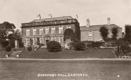
Possibly on the site of an earlier house, it dates from 1677. Further remodelling was done in the 1720s by William Etty with the encasing of the south range. This resulted in a two-storeyed, seven-bay mansion with hipped roof behind a solid parapet (Figure 7).
Gate piers [Grade II – No 1200237]
Steps descend from the central door to a drive leading across the front of the house. This passes through two sets of large, square, panelled gate piers with moulded caps, attached at right angles to each corner of the front elevation of the house by short screen walls. It is these gate piers that have proved of particular interest to architectural historians. A letter from Etty to Arthur Ingram dated December 1718 discusses their design and construction at some length, offering a ‘new designe for the palisade gates for a Coach to pass through, which I think may Be very proper in Stormy weather, or as opportunity requires’ (WYASL WYL100/F/15). Etty provided Ingram with different prices for ‘new peers’ or ‘making use of the Old’, an approach that comes up throughout this letter and another of February 1718/19, revealing that his brief was to make best use of old material and retain existing features, wherever possible, throughout the house: ‘I am as much for Saving yr Honour Money as yr Selfe’ (ibid). A ‘Note of Work done’ in May 1720 and signed ‘Will: Etty:’ itemises designs for these gate piers, and George Jackson, ‘Painter’, was paid for work on ‘2 pair of pallissaid gates’ (ibid).
Stables
Built to designs of George Fowler Jones c. 1887 (WYASL WYL115/XC/Box16/23)
Gardens and pleasure grounds
In front of the hall’s southern façade are two terraces with stone steps in the middle (Figure 7). These probably date from the work done in the 1720s. These led to an open area of grass with a tennis court in the early 20th century (Figure 8). To the southwest was an orchard and to the east pleasure grounds, with areas of shrubbery immediately around the hall.
Kitchen garden
Located just northeast of the hall, this probably dates from the 1720s when Thomas Richardson was paid for ‘repairing or Making his Gardings att Barraby’ (WYASL WYL100/F/15). Measuring about an acre, by 1890 it had a small glasshouse on the northern wall. By 1905, this had been removed and a new glasshouse added on the southern wall.
Park and plantations
Barrowby Park
Immediately south of the hall, it covered 41 acres in 1827, with an additional 14 acres of pasture to the west. By 1890, the main parkland had expanded to 53 acres and the separate western section to 21 acres.
Plantations
Carr Wood to the west covered 17 acres in 1827 and by 1890, there were small plantations (5 acres) around the fishpond.
Water
The ‘Fishpond’ shown on the 1827 plan (Figure 1) may well have been part of a larger water feature such as a canal from the remodelling of the 1720s. Also depicted on the plan are two rectangular pieces of water that may have part of the layout and had gone by the 1840s.
Books and articles
Barnewall, R. V., Alderson, E. H. and Selwyn, W. 1822. Reports of Cases Argued and Determined in the Court of King's Bench, Volume 5. London, J. Butterworth & Son.
Colvin, H. 1978. A biographical dictionary of British architects, 1600-1840. London, John Murray.
Jeffreys, S. 2018. ‘Hawksmoor’s Vision of Wray Wood, Castle Howard’. Architectural History 61, 37-72.
Thoresby Society 1935. The Publications of the Thoresby Society, Volume XXXIII. Leeds, John Whitehead and Son Ltd.
Primary sources
Historic England Archives (HEA)
SA01938 Sale brochure for Barrowby Hall and lands, 1960
Royal Society Archives (RSA)
L&P/7/23 Paper describing the quantity of rain that fell at Holme and at Barrowby, 1772-7
The National Archives (TNA)
C 13/24/16 Amherst vs Smith court case, 1803
V&A Museum (VAM)
XRP 333 [18338, 18340, 18341 & 18344] Photos by George Fowler Jones of Barrowby Hall, 1887
West Yorkshire Archive Service, Leeds (WYASL)
WYL100/F/15 Papers of Ingram family of Barrowby, 1674 – 1750
WYL115/E5/7 Various estate papers: Barrowby and Garforth, 1811 - 1830
WYL115/XC/Box1/1 Survey of Barrowby Hall estate by John Paver, 1827
WYL115/XC/Box16/23 Plans for new stables by George Fowler Jones, 1887
Maps
Ordnance Survey 6” 1st edition, surveyed 1845 to 1847, published 1850
Ordnance Survey 25” 1st edition, surveyed 1890, published 1892
Ordnance Survey 25” revised edition, surveyed 1905, published 1908
Ordnance Survey 25” 2nd revised edition, surveyed 1938, published 1939
Figure 1 – Detail from survey plan by Paver of Barrowby estate. West Yorkshire Archives Services Leeds (WYL115/XC/Box1/1)
Figure 2 – Barrowby Hall estate from Ordnance Survey 6” 1st edition, surveyed 1845 to 1847, published 1850. National Library of Scotland CC-BY-NC-SA.
Figure 3 – Barrowby Park from Ordnance Survey 25” 1st edition, surveyed 1890, published 1892. National Library of Scotland CC-BY-NC-SA
Figure 4 – Barrowby Hall from the southwest. Photo by George Fowler Jones, 1887. V&A Archives, XRP 333 18338. ©Royal Photographic Society Collection / Victoria and Albert Museum, London.
Figure 5 - Barrowby Hall from the west. Photo by George Fowler Jones, 1887. V&A Archives, XRP 333 18344. ©Royal Photographic Society Collection / Victoria and Albert Museum, London.
Figure 6 – Carr Wood from Ordnance Survey 25” 2nd revised edition, surveyed 1938, published 1939. National Library of Scotland CC-BY-NC-SA.
Figure 7 – Barrowby Hall and garden terraces, c. 1910. Postcard by Bramley from https://www.ianatkinson.net/garforth/photos/misc-places.htm#barrowbyhall
Figure 8 – Barrowby Hall pleasure grounds and tennis court c. 1906. Postcard by Parkinson & Roy from https://www.ianatkinson.net/garforth/photos/misc-places.htm#barrowbyhall
")


