Originally one of three royal parks attached to Knaresborough Castle, Bilton Park was created in the late 13th century. It remained in use as a deer and horse park until 1630 when it was sold off by the Crown to Thomas Stockdale. Stockdale or his son, William, developed one of the park lodges into Bilton Hall by the early 1670s. While much of the former park, covering c. 750 acres, became farmland, the area to the north remained as parkland and woodland. This has stayed largely intact, as the immediate grounds of the hall were developed first in the late 18th century and then after the rebuilding of the hall in the 1850s. Subsequent owners have made minor modifications to the designed landscape of Bilton Park but the relative lack of development of the area ensures the legibility of this ancient park.
Estate owners
Bilton was owned by Gilbert Tison in 1086 but by c. 1100-18, it had passed into the hands of the King with other lands around the royal manor of Knaresborough. In 1328, the honour and castle of Knaresborough, including Bilton park, was given to Queen Phillipa (wife of Edward III). It was then transferred to John of Gaunt (Duke of Lancaster) in 1372 and became part of the Duchy of Lancaster. With the accession of Henry IV in 1399, the Duchy became a Crown possession and Bilton park was managed by a series of royal appointees, with the last, William Alston, in post in 1627.
By the direction of Charles I, Alston agreed to sell the leasehold of Bilton Park to Thomas Stockdale in 1630 and this was confirmed the following year. Stockdale died in 1653 and the estate went to his son, William. He died without heirs in 1693 and left Bilton Park first to his sister, Elizabeth and then to his nephew, Christopher Walters, who changed his name to Stockdale after inheriting the following year. Thomas, Christopher’s son, was forced to sell in 1732 after incurring large debts. The purchaser was George Liddell who tried to sell it to John Watson two years later but the sale only went through in 1741 after Liddell’s death.
George Watson, John’s son, left Bilton Park in trust for his nephew, John Farside, on his death in 1755. John changed his name to Watson and came of age in 1771. His son, John Farside Watson, inherited first in 1810 and then his infant granddaughter, Georgina, on her father’s death in 1831. Georgina Watson died in 1898 and the estate was put up for sale in 1920. The hall and c. 62 acres were finally bought in 1928 by John Atkinson Jowett, after whose death in 1944, it was sold by his trustees in 1947. The hall and gardens were bought in 1987 and converted into the present care home.
Key owners responsible for major developments of the designed landscape and dates of their involvement:
King Edward I c.1280 – 91
Thomas Stockdale 1631-53
William Stockdale 1653-93
John Watson c.1771-1810
Georgina Watson c. 1852-98
John Atkinson Jowett 1928-44
Early history of the site
The lands including Bilton Park had come into the possession of the king c.1100-18 at the same time as Knaresborough Castle was being built (Clay 1965, 21). Around 1280-90, the parks of Haywra [Havera], Hay and Bilton linked to Knaresborough Castle were enclosed (TNA E 101/133/25, E 32/238 & Grainge 1871, 205). The Hay was to the northeast of the castle, Havera to the southwest and Bilton due west and are shown on Warburton’s map c. 1720 (Figure 1). While they may have functioned as deer parks at this stage, they also served as royal studs (Moorhouse 2007, 114). The exact boundaries of the enclosure are not known but are likely to be similar to the later Bilton Park estate as shown on the 1768 map and covered c. 750 acres (Figure 2, WYASL WYL132/141).
In 1372, when the park transferred to the Duchy of Lancaster, there was a reference to John of Beckwith being appointed to the office of bailiff of Bilton Park deer park (Armitage-Smith 1911, 94). Given it was now holding deer, it is possible that he lived there in a lodge. By c. 1500, Peter Slingsby, keeper of Knaresborough Castle, was said to have resided in the park-keeper’s lodge, probably on or near the site of Bilton Hall (Grainge, 207), as the 1768 map (WYASL WYL132/141, Figure 3) has a ‘Lodge Field’ next to the hall to the east. There may have been more than one building as an order from 1615-6 referred to ‘the repair [of] the lodges in Bilton Park’ (TNA DL 44/996).
Chronological history of the designed landscape
1630 – 1852
It continued to function as a deer park until 1630 when the area was sold off to Thomas Stockdale (WYASL WYL132/16-19). Stockdale paid £1,880 for the property but the Duchy of Lancaster kept the freehold with the former having to pay £40 a year rent (ibid). Thomas, who died in 1651, or his son, William, built Bilton Hall on or near the site of one of the former park lodges. This was a sizeable property having 22 hearths in 1672 (TNA E 179/210/400). In 1649, Thomas Stockdale leased various lands and buildings in Bilton Park (WYASL WYL132/45-8) that would suggest sections of the park had been converted into farmland by this stage. Outstanding bills in connection with the estate of Christopher Stockdale (William’s nephew and heir) who died in 1714, listed ‘Repairs at Bilton Park, £21 10s 9d & Garden Seeds, £1 10s’ (WYASL WYL132/144). The former may have referred to the park pale as the Warburton map of c.1720 showed it still in place (Figure 1). The latter may have been for the large walled garden shown on the 1768 map adjacent to the hall.
In 1720, Thomas Stockdale had come into his inheritance but unwisely mortgaged all his lands in Yorkshire to Earl of Montrath for £1,000 in South Sea Company Stock (WYASL WYL132/24). Despite trying to raise money by further mortgaging his estates, he was finally forced to sell to one of his creditors, George Liddell, in 1732 with the property then valued at £7,225 (WYASL WYL132/30). Liddell entered into an agreement to sell Bilton Park to John Watson in 1734 (WYASL WYL132/31) and it seems by this stage, the hall was not being maintained. On the 11 August of that year, a letter from Mr Robert Fishwick (steward?) to George Liddell noted:
‘The small part of the house roof that is fallen at the bottom was not to be discerned by any, for it is one of pedestals that was over the kitchen sluices and let water in and a little water ran down the grey hanging Mr Watson bought that was in my old Ladys Room: the damage is very small, £30 will do all. Tis not above two months since it fell in and I wrote M Wilson [Watson?] word to London of it’ (WYASL WYL132/168).
In 1731, Stockdale had entered into an agreement with Joshua Hardisty to sell nearly 300 trees for £100 (WYASL WYL132/185). The majority of these came from ‘The Park’ to the north of the hall with others being removed from ‘The Railes’ to the southeast of the hall and from the east and west hedgerows leading to the hall. These trees had been numbered earlier and represented about a quarter of those standing at the time. Some of this was likely to be ancient wood as the area in the park known as Bilton Banks next to the river was a source of timber for the manor of Knaresborough in the 16th century (Grainge 1871, 207).
The estate was finally sold to John Watson on 6/7 May 1741 for £8,500 and £1,765 13s 3 ¼d secured (WYASL WYL132/32) but it is not clear whether he lived there as there is no mention of it in his will written in 1747 and proved on the 17 January 1749 (TNA PROB 11/767/205). A Copy Court Roll for Knaresborough stated that George Watson, eldest son and heir of John Walton of Malton deceased, was admitted having 2 messuages and 1 ancient building in Bilton, once held by his father (WYASL WYL132/60). One of these buildings was Bilton Hall, the other messuage was the adjacent farm with the ‘ancient building’ perhaps the other former lodge. On the 1768 map there was a building marked ‘D’ near Great Park with a lane leading to it from the river, which was in the area of later coal mining (Figure 4).
George Watson died in 1755 and his heir was his nephew John Farside (later Watson) who was aged c. 5 years, so the estate was run by trustees until c. 1771. There are two estate maps (WYASL WYL132/141 & /142) and a survey from this period (WYASL WYL132/135) that probably represent the designed landscape of fifty years or more earlier, given its ownership history. With the exception of the ‘Park’ to the north and the wooded areas to the northwest next to the river Nidd, the rest of the former deer park was now fields. Next to Bilton Hall was a (kitchen) garden to the south and a garth or enclosure to the east (Figure 3).
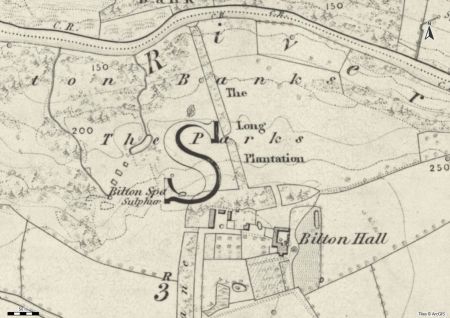
John Watson came of age in 1771 and the following year leased coal and collieries for 11 years, with the rent being £100 p.a., ½ of all sums above £20 a year of sales and £5 an acre for every acre ploughed up (WYASL WYL132/82). With this revenue, he made changes to the estate including adding the stable block to the north and remodelling the designed landscape around the hall. The main change was to the park, where significant planting had been added by 1849 including ‘The Long Plantation’, a strip of woodland from north of hall to river bank, divided into two (Figure 5). The latter feature may have been put in place for visitors arriving by the river or visiting it from the hall.
A series of ponds in the park, just north of Bilton Spa, comprised of three small rectangular pools in a line southwest of the main large pond that then drained into the river. It is possible that they were part of the sulphur spring complex where John Watson added a stone basin in 1778 to capture the water (Grainge 1871, 215). Grainge (ibid) described the water as
‘beautifully transparent, and bubbles of gas, every two or three minutes, rise to the surface of the water; and the stream, as it flows down the hill, shows its petrific quality, by turning the leaves, sticks, and mosses, in its track, into stone’.
The grounds around the hall had been changed with perimeter planting west of Bilton Hall Lane opposite the hall and to north of hall, leading to the Long Plantation. To the east of hall, a lawned area had been added, together with a small pond to the southwest and possibly an orchard due west (Figure 5). While most of the earlier woodland to the northwest remained, the former Wood Close (or Low Bottoms) between Oak Bank and Hollin Bank was now planted (Figure 6). Between 1824 and 1851, the estate was put up for rent as John Farside Watson and then his daughter, Georgina, lived elsewhere.
Later history
Georgina Watson and her mother returned to live at Bilton Park c. 1851 and had plans to alter both the hall and the surrounding designed landscape. Three years later, Bilton Hall was largely rebuilt (Grainge 1871, 214) and from 1852, there were major sales of timber indicating the clearance of wood. The first sale in March 1852 included 254 oaks and 441 other mature trees from Bilton Banks (Leeds Mercury, 13 March). The second in March 1854 was for 132 oak and 556 other species of trees including sycamore, ash, elm and poplar also from Bilton Banks (York Herald, 14 February). The last sale in December 1854 of nearly 600 mature trees came from across the estate including the woodland to the northwest and also the ‘Hall Plantations’ that had been more recently planted (York Herald, 23 December).
By 1889, there was a new carriageway from northern point of Bilton Hall Lane to southern front of remodelled hall (Figure 7). On the former east lawn, there were now paths with evergreens in a formal layout with a mixed shrubbery to the north with a large regular pool. The walled kitchen garden had been modified with its southeast corner removed and a garden building constructed between it and the orchard. Georgina Watson died in 1898 and the estate put up for sale in 1920. It was finally bought by John Atkinson Jowett in 1928. By this point, the gardens to the east of the hall had been simplified and a glasshouse (vinery) had been added to the garden building south of the orchard (Figure 8).
Further modifications to the grounds immediately around the hall were made by Jowett before 1932. These included an extension of the glasshouse (vinery) south of orchard area, an avenue of trees next to main carriageway to the hall and the reduction of the pond into a regular shape (Figure 9). The parkland and woodland to the north remained unchanged. In 1947, following Jowett’s death three years previously, Bilton Hall and its grounds were once again for sale. By the late 1960s, the hall was owned by Dowsett Engineering Company and then it was converted to its present use as a residential care home in 1987. Some of the former woodland is now owned by the Woodland Trust including Coalpits Wood, Bilton Banks and Spring Wood.
Location
Bilton Park lies just under a mile (1.5km) west of Knaresborough and 2½ miles (4km) northeast of Harrogate.
Area
The historic designed landscape of Bilton Park at its greatest extent in the medieval period covered c. 750 acres (303 ha).
Boundaries
The northern boundary is formed by the River Nidd from SE 339 576 in the east to SE 322 586 in the west. The western boundary goes from the river via Bilton Lane at SE 319 578 south to just north of High Harrogate (SE 313 560). The southern boundary goes from there to Bilton Park Gate at SE322 565 and then continues east along Forest Lane until it reaches the river. The eastern extent runs along the edge of the Knaresborough parish boundary north to the river at SE 339 576.
Landform
Around the hall and the pleasure grounds, the underlying bedrock is Brotherton Formation of limestone. The park and plantations’s bedrock is Millstone Grit Group – Mudstone containing sandstone. This is overlaid with superficial deposits of clay, sand and gravel. The soil throughout is base-rich loam and clay but they are slowly permeable, seasonally wet and slightly acid with impeded drainage giving moderate fertility.
Setting
Bilton Park lies in the National Characterisation Area 30 (Southern Magnesian Limestone). This is a ridge of elevated land running north-south with light, fertile soils. It is mainly open, rolling arable farmland enclosed by hedgerows, plantation woodlands and estate parkland. The watercourses that run through it, such as the River Nidd, provide areas of wetland. The limestone has provided much building material for the many large houses in the area.
Bilton Hall stands on an elevated position at 95m AOD, with the ground sloping down north to the river at 60m OD. To the east, the land falls away again to the river at 45 OD. To the south and west the ground stays at c. 90m OD, this large piece of flat land forming the core of the medieval park.
Entrances and approaches
Original entrance off Bilton Hall Lane
Access to the hall was originally via the road immediately north of the corner of Bilton Hall Lane to the stables.
Carriageway off Bilton Hall Lane
This was added sometime after 1853 with the remodelling of the hall. An avenue of trees had been planted probably after the acquisition by Jowett in 1928.
Principal buildings
Bilton Hall [Grade II - NHLE 1149915]
Possibly on the site of one of the medieval park lodges, it was built in the middle of the 17th century with a substantial remodelling in the 1850s.
Stableblock [Grade II – NHLE 1149916]
Attached to the hall, this stableblock is thought to date from the late 18th century.
Gardens and pleasure grounds
The 1768 map (Figure 3) gives little detail on the grounds immediately around the hall, although the small area due west of the hall (No 36) and No 37, labelled as ‘Garth’, may have been garden areas. Changes to the gardens (Figure 5), possibly put in the late 18th century, show the area to the north and east had been developed as a pleasure ground. To the southwest there was an open area of lawn with a pond. With the remodelling of the hall in the 1850s, a more formal garden with large evergreens (Wellingtonias?) was created southeast of the hall (Figure 7).
Kitchen garden
The area marked as ‘Garden’ on the 1768 map (Figure 3) probably dates to the building of the hall in the mid to late 17th century. Outstanding bills in connection with the estate of Christopher Stockdale who died in 1714, included ‘Garden Seeds, £1 10s’ (WYASL WYL132/144). An orchard area was added possibly in the late 18th century. The main kitchen garden area was altered in the 1850s when the hall was rebuilt and a new carriageway put in south of the hall. South of the orchard was a new area that included a garden building that later became a vinery (Figure 7).
Park and plantations
Medieval park
An ‘Inquisition touching the pale made by the Bilton tenants’ made on the 20 April 1622 (WYL132/179 & 180) gives an indication of its likely boundaries. In the west, it is next to Bilton (village) Green and to the south next to ‘Long lands’ north of Forest Lane. On the first edition 6” OS map, ‘Bilton Park Gate’ is listed at SE 32167 56535 to the southwest. With details from the map of 1768, its possible extent is shown on Figure 10 and covered c. 750 acres.
The Park
While most of the medieval deerpark became fields, an area to the north of Bilton Hall remained as parkland with scattered plantations, some of which was cleared in the mid 18th century. It covered about 55 acres and is still extant.
Spring Wood Oak Bank/Coal Pits Wood [also known as Bilton Banks]
Next to the park on the west, it was part of a series of plantations next to the river and was in place from the mid 18th century and possibly earlier. It covered about 60 acres and is still extant.
Water
There was a small fishpond (0.138 acres) 120m (400ft) southwest of Bilton Hall in the late 19th century however it likely to date from much earlier as the 1768 map marks the area as ‘Fish pond close’. There were also a series of 3 small regular pools and a larger irregular pond just north of Bilton Spa that may date from the 1770s.
Books and articles
Armitage-Smith, S. 1911. John of Gaunt’s Register Volume 2, London, Royal Historical Society.
Clay, C. T. 1965. Early Yorkshire Charters: Volume 12, The Tison Fee. Leeds, Yorkshire Archaeological Society.
Grainge, W. 1871. The History and Topography of Harrogate, and the Forest of Knaresborough. London, John Russell Smith.
Moorhouse, S. 2007. ‘The Medieval Parks of Yorkshire: Function, Contents and Chronology’ in Liddiard, R. ed. The Medieval Park: New Perspectives. Macclesfield, Windgather Press.
Primary sources
The National Archives (TNA)
DL 44/996 Warrant for the delivery of timber for the repair the lodges in Bilton Park, Yorkshire, 1615-6.
E 32/238 Roll and file of proceedings before Robert de Hertford and William de St Quintin, justices of oyer and terminer for trespasses in Knaresborough Chase and in the parks of Haywra and Bilton, 1290-1.
E 101/133/25 Particulars of expenses at Bilton in Knaresborough forest, 1280-1.
E 179/210/400 Hearth tax for the West Riding, 1672
West Yorkshire Archive Services Leeds (WYASL)
WYL132/16 Agreement between William Alston and Thomas Stockdale of Preston to sell Bilton Park to Thomas Stockdale, 1630.
WYL132/17 Licence by Charles I to William Alston, Sir John Temple and Roger Nicholls to enable them to alienate (transfer property) to Henry Benson, Francis Wright junior, John Stockdale and John Otby, Bilton Park, once part of the Duchy of Lancaster, 1 February 1631
WYL132/18 William Alston, Sir John Temple and Roger Nicholls to Thomas Stockdale, Henry Benson, Francis Wright junior, John Stockdale (brother of Thomas) and John Otby, sale of Bilton Park, 12 February 1631.
WYL132/19 Assignment of leases in Bilton Park to Thomas Stockdale granted from 1615 to date by King James & King Charles, 12 February 1631.
WYL132/24 Algernon, Earl of Montrath to Thomas Stockdale surrender of his interest in Stockdale’s lands in Yorkshire, reciting deed of November 1720 whereby Stockdale mortgaged all his lands in Yorkshire to him for £1,000 in South Sea Company Stock, 23 December 1720
WYL132/30 Sale by Thomas Stockdale to George Liddell of Bilton Park estate, 7&8 November 1732
WYL132/31 Articles of agreement between George Liddell of Ravensworth Castle and John Watson of Malton for the sale of Bilton Park, 6 Apr 1734
WYL132/32 Lease and release the estate of Bilton Park to John Watson, 6/7 May 1741
WYL132/45-8 Lease for 21 years between Thomas Stockdale and various parties of property in Bilton Park, 1649
WYL132/60 Copy court roll of Knaresborough whereby George Watson admitted, 8 February 1749
WYL132/82 Lease between John Watson and various parties for collieries, 1 June 1772
WYL132/135 Survey of Bilton Park estate, nd (accompanies /142)
WYL132/141 Map of Bilton Park estate, 1768
WYL132/142 Map of Bilton Park estate, nd c. 1755-70
WYL132/144 Accounts of Elizabeth Stockdale, 1714-8
WYL132/168 Letter from Robert Fishwick to George Liddell, 11 August 1734
WYL132/179 Inquisition re park pale by Bilton tenants, April 1622
WYL132/180 Inquisition into men who maintain park pale, 20 April 1622
WYL132/185 Articles of agreement between Thomas Stockdale and Joshua Hardisty re sale of trees in Bilton Park, 22 Jan 1722
Maps
Ordnance Survey 1st edition 6”, surveyed 1847 to 1849, published 1854
Ordnance Survey 1st edition 25”, surveyed 1889, published 1892
Ordnance Survey Revised edition 25”, revised 1907, published 1909
Ordnance Survey Revised edition 25”, revised 1932, published 1934
Figure 1 – Bilton Park shown on Warburton’s map of c. 1720. La Biblioteca Virtual del Patrimonio Bibliográfico, Spain. CC BY
Figure 2 – Bilton Park estate, 1768. West Yorkshire Archives Services Leeds (WYL132/141)
Figure 3 – Bilton hall and immediate grounds, 1768. West Yorkshire Archives Services Leeds (WYL132/141)
Figure 4 – Bilton Park west showing possible of possible lodge ‘D’ near ‘Great Park’, 1768. West Yorkshire Archives Services Leeds (WYL132/141)
Figure 5 – Long Plantation, new pleasure grounds and ponds near Bilton Spa on the 1st edition 6” OS map surveyed 1847 to 1849, published 1854. National Library of Scotland CC-BY.
Figure 6 – Wider Bilton ground including the park and woodlands on the 1st edition 6” OS map surveyed 1847 to 1849, published 1854. National Library of Scotland CC-BY.
Figure 7 – Revised gardens and pleasure grounds of Bilton Hall on the 1st edition 25” OS map surveyed 1889, published 1892. National Library of Scotland CC-BY.
Figure 8 – Revised layout of kitchen garden and grounds of Bilton Hall on the revised edition 25” OS map revised 1907, published 1909. National Library of Scotland CC-BY.
Figure 9 – New avenue on carriageway and reduced pond at Bilton Hall on the revised edition 25” OS map revised 1932, published 1934. National Library of Scotland CC-BY.
Figure 10 – Likely boundaries of medieval Bilton park on the 1st edition 6” OS map surveyed 1847 to 1849, published 1854. National Library of Scotland CC-BY.

")
")
")


