Set in the Yorkshire Wolds, Birdsall House has been the home of the Willoughby family who have used the natural landscape to create a suitable setting for it over a 200 year period. Although the hall had been built around the start of the 17th century, the designed landscape that can be seen today only started taking shape in the early 18th century. While Thomas Sotheby may have made some improvements prior to 1729, it was his son-in-law, Thomas Willoughby, who was responsible for the first major changes with possible advice from Thomas Knowlton, gardener at Londesborough. His son, Henry, continued to develop the grounds from 1748 until he inherited the estates and title of his cousin, the 4th Lord Middleton, in 1781. He again may have sought the advice of designers, perhaps including Thomas White.
While Henry Willoughby’s attention and resources were focused on his new estate at Wollaton in Nottinghamshire, after his death in 1800 his son, Henry (6th Lord Middleton), started once again to remodel Birdsall. This involved expanding the parkland to the east and in 1824, building a new church to the northeast to replace the former one next to the hall. Lord Middleton died in 1835 and his title went to his cousin, Digby but it was another cousin, Henry, who made Birdsall his home, where he stayed after becoming the 8th Lord Middleton in 1856. It was during his tenure that the last major changes were made with the final expansion of the parkland to the east and a new kitchen garden in 1873. There has been little change since and the designed landscape remains an important setting for Birdsall House.
Estate owners
In 1086, the land at Birdsall was divided between the estates of the Archbishop of York, Nigel Fossard and Ulfkil (https://opendomesday.org/place/SE8164/birdsall/, consulted 5 January 2026). Fossard’s lands came into the possession of Peter de Mauley [aka de Malo Lacu], through his marriage in 1214. The last Mauley male heir, Sir Peter, died in 1415 without issue and the Birdsall manor devolved to his sister, Constance, wife of Sir John Bigod of Settrington. Their descendent, Sir Francis Bigod, was executed in 1537 and his estates were forfeited to the Crown. Birdsall manor though had been granted to his mother, Dame Agnes Bigod (later Eure), for life in 1515. This was granted to Robert Sotheby of Pocklington in 1558.
Robert Sotheby’s son, Thomas, started to acquire further property in Birdsall from 1581 and built Birdsall House c. 1600. The Sotheby family remained the owners until the death of Thomas in 1729, when Birdsall became the property of Thomas’ daughter and son in law, Elizabeth and Thomas Willoughby. Their eldest son, Thomas, inherited in 1742 but on his death six years later his brother, Henry, was his heir. Henry’s son, Henry Willoughby (6th Lord Middleton), died without issue in 1835. His estates went first to his cousin, Digby Willoughby (7th Lord Middleton) and then to another cousin, Henry (8th Lord Middleton) in 1856. His descendants still own the Birdsall estate.
Key owners responsible for major developments of the designed landscape and dates of their involvement:
Thomas Sotheby c. 1600 – 24
Thomas Sotheby 1709 – 29
Thomas Willougby 1729 – 42
Henry Willougby, 5th Lord Middleton 1748 – 1800
Henry Willougby, 6th Lord Middleton 1800 – 35
Henry Willougby, 8th Lord Middleton 1856 – 77
Digby Willoughby, 9th Lord Middleton 1877 - 1922
Early history of the site
The Domesday book recorded that the Archbishop of York held land at Birdsall in 1066, which it retained in 1086 and was part of a larger area of 15 carucates (c. 1800 acres). There were two other lords in 1086, Nigel Fossard, whose landowning was not recorded as it was possibly waste and Ulfkil, who had 2 carucates (c. 240 acres). Peter de Mauley I (also known as de Malo Lacu) married the heiress of the Fossard estates in 1214, which included part of Birdsall. In 1238, he granted Meaux Abbey ‘the mill of Bridesall, with the Holme by the mill-pond, and power to improve the said pond, and free access thereto [and the mill cut], and the suit of the mill from twelve bovates of land…and four bovates’ (PRO 1903, 234). This amounted to 2 carucates (c. 180a) of land. The mill was listed as the property of the Abbey in 1535 (PRO 1825, 108). Two mills were noted as part of the manor of Birdsall in 1558 (YAS 1887, 215). It is possible that the original (or Meaux Abbey) mill was next to the Birdsall House ponds, with the mill 1 mile to the northeast (SE 823 663) put in later. The Abbey had a monopoly in the Birdsall manor for grinding corn but this would have been revoked with its dissolution.
A survey from 1279 showed that the Archbishop of York had 20 carucates of land and Peter de Mauley II had 14 carucates equating to c. 4080 acres in Birdsall (Surtees 1867, 271), which was the size of the later civil parish. From the Archbishop’s landowning, 4 carucates were held by 4 tenants. Of Peter de Mauley’s land, 2½ carucates were divided between 6 tenants with a further 6 carucates described as ‘demesne land’ (i.e. in his direct occupation) in his Inquisition Post Mortem of the same year (YAS 1891, 195). He had been granted ‘free warren’ in his demesne lands in 1254 (PRO 1908a, 266), so there may have been a park there but no evidence has been found for this. There was a hall though as Edward I was recorded visiting it on 11 October 1304, when he issued letters patent or royal legal documents (PRO 1898, 261). Peter de Mauley IV, who died in 1310, was part of Edward I’s court and his Inquisition Post Mortem listed him having a ‘capital messuage, 38 bovates (4¾ carucates) in demesne and 40a of meadow’ in Birdsall (PRO 1908b, 103).
With the death of Sir Peter Mauley without issue in 1415, the manor of Birdsall and the lands there were assigned to Maud, his widow, for life. When she died in 1438, they transferred to her sister-in-law, Constance Bigod, and her descendants (PRO 2009, 174). Agnes, Sir Ralph Bigod’s widow, was also granted Birdsall for life on the death of her husband in 1515 (Surtees 1884, 56). Sir Ralph’s grandson, Sir Francis, was executed for treason in 1537 and all his lands forfeited to the Crown, including Birdsall. Following the death of Agnes Eure (formerly Bigod), Birdsall manor also reverted to the Crown and on 22 May 1553, it was leased to Robert Beverley for 21 years (PRO 1936, 133). The lease was transferred to Edmund and Frances Wright on 18 December 1554 and then to Thomas Wood on 2 March 1558 before being granted to Robert Sotheby on the 10 May that year (PRO 1939, 235 & 342).
The manor was listed as having 30 messuages, 30 cottages and 2 mills with lands there (YAS 1887, 215). Robert’s son, Thomas, acquired more land in Birdsall between 1581 and 1597 and c. 1600, he built Birdsall House. The size of his landholding at the time is not known but one of the other major landowners was the Thorpe family. They acquired the lease of the rectory at Birdsall and the grange (farm) with glebe lands in 1568, formerly the property of Watton Abbey (PRO 1964, 313). In 1601, Thomas Sotheby was in dispute with Roger Thorpe over enclosures made of common land (WYASL WYL100/BL/A/3), suggesting they were trying to consolidate their landholdings.
Thomas Sotheby died in 1624 and was succeeded by his grandson, Robert, two years later. Robert’s son inherited the estate as a minor in 1636. By the 1660s, there were further proposals by the major landowners including Robert Sotheby, Lord Irwin and Francis Thorpe to enclose the open fields of Birdsall ‘for better husbandry’ (WYASL WYL100/BL/A/13). These were finally agreed thirty years later in 1691 (WYASL WYL100/BL/A/14), although disputes over the land continued for another 10 years. In 1672, Birdsall House had 10 hearths, which was a mid-sized property as the largest mansions had over 20 hearths. After the death of his first wife, Thomas Sotheby (son of Robert) married Anthonina, daughter of Dr Tobias Wickham, in 1693. From a petition taken out by his father-in-law on 18 July 1695, it was clear that Thomas had many debts and that the supposed ‘commodious and substantial’ manor house at Birdsall was in fact ruinous and uninhabitable (NYA ZQH 7/45/3).
In 1709, Robert Sotheby died and his son, Thomas, inherited the estate. In 1715, he was the sole heir to the estate of his maternal uncle, John Lister (TNA PROB 11/545/371), which would have given him funds to spend on improvements at Birdsall. A drawing by Samuel Buck c. 1720 (Hall 1979, 35) shows a substantial building flanked by two service buildings in a courtyard. In 1719, Thomas’ daughter and heir, Elizabeth, had married Thomas Willoughby, the younger son of Sir Thomas (later 1st Lord Middleton) of Wollaton Hall in Nottinghamshire.
Chronological history of the designed landscape
1729 – 1781
Thomas Sotheby died on 11 November 1729 but his son-in-law and daughter were already making plans to alter the landscape. They had contacted Thomas Knowlton, gardener to Lord Burlington at Londesborough. On 29 October, Knowlton noted in a letter to Richard Richardson that he was due to visit Mr Willoughby, who had asked him to come 10 days earlier (Henrey 1986, 117). Knowlton had been employed by Burlington in 1726 and he was soon being asked for advice from neighbouring estate owners such as Sir Marmaduke Constable at Everingham (8 May 1727; Roebuck 1976, 26) and Sir Charles Hotham at Dalton Hall (24 August 1729; Henery 1986, 103).
On the 17 November 1729, Knowlton wrote to Samuel Brewer
‘as to the Stars Stons [fossils] you mention at Bugthorpe I was there…at a gentlemans seat…[for] two or 3 days on account of measuring his ground for a new Design for a garden & paddock & shall be that way again within a month’ (ibid, 118).
He could therefore be visiting Birdsall as Bugthorpe is c. 5 miles southwest and perhaps that where he was lodging. He certainly had visited Birdsall before July 1730 as he sent Brewer some ‘cockle shells out of the body of a large stone at Birdsall’ (ibid, 130).
There is a plan of the grounds at Birdsall in 1730 (copy in Neave and Turnbull 1992 - https://archive.org/details/landscapedparksg0000neav/page/17/mode/1up). It is likely that it represents the layout at the time rather than a proposal, with the area of the hall, gardens, orchards and plantations covering 35a 2r 24p. As Knowlton only refers to ‘a new design for a [kitchen] garden and paddock’, the wooded area ‘Giserdale’ with its walk cut through it and the regular shaped ponds were probably already in place but not the extant walled garden just north of Birdsall House, shown on a plan from the late 1750s (copy in Neave and Turnbull 1992 - https://archive.org/details/landscapedparksg0000neav/page/40/mode/1up). This is perhaps what Knowlton was referring to, as a drawing c. 1761 (NUSC Mi A 132 f.23) has an ‘old hothouse’ that presumably had been in place for some years. In 1730, Knowlton was creating a new walled kitchen garden at Londesborough with a ‘stove’ or hothouse 600m to the southwest of the hall and Thomas Willoughby may have wanted the same.
In 1736, it seems that Knowlton was again expected at Birdsall to review some (completed?) work. In a letter on 22 October to Samuel Brewer, he advised that
‘I have not been from Home this several weeks nor shall I next week…because I imagine I shall be sent for to Mr Duncombe…very soon they I know are drawing to conclusion of what I had…set out…likewise Mr Willoughby where I have promised for a long time to go’ (Henrey 1986, 148).
Thomas Duncombe owned Duncombe Park near Helmsley, about 21 miles northwest of Birdsall and Knowlton had been working for him since at least February 1734 (HHC UDDEV/60/86). It is conceivable that Knowlton could have visited Birdsall en route to Duncombe. When he went between 1730 and 1736 is unknown or indeed whether he was responsible for the later changes to the landscape at Birdsall.
Thomas Willoughby died in 1742 and he was initially succeeded by his eldest son, Thomas. With the latter’s early death in 1748, the estate went to his second son, Henry. In 1754, he commissioned a survey of Birdsall (NUSC Mi Da 149) that showed the area of ‘House gardens and plantations’ had increased to 50a 3p with parts of High Willows and Langhill now included. Willoughby had also diverted the public road to the east of the hall and only one house and croft now remained next to High Willows.
He was clearly planning further changes as he took further land into his own hands on 25 March 1757, including the 8 acres due east of the hall and to the west of the new road (ibid). This area together with the hall gardens, plantations and Langhill is shown on what is probably an improvement plan (copy in Neave and Turnbull 1992 - https://archive.org/details/landscapedparksg0000neav/page/40/mode/1up) made c. 1757-60. The designer is unknown but one possibility is Francis Richardson of Worksop who had prepared plans for other Yorkshire estates such as Cannon Hall (c. 1756-60; Cowell 2009, 187), Kirklees Hall (1757; ibid, 212) and Cusworth Hall (1761; ibid, 191). While Langhill remained as fields rather than open parkland, the nursery and ‘deer paddock’ were put in place as they are mentioned in a survey of 1762 (NUSC Mi Da 149).
Another part of the plan that was possibly new was the long north-south terrace stretching from the northwest corner of the ‘Low Garden’ (extant walled garden) to the southwest of the ‘High Garden’ (earlier garden next to the hall). Detail of work done in the grounds between 1761 and 1763 (NUSC Mi A 132/1) included the following entries for 1762:
7 May Spittled [weeded] the terrace walk
8 May Raking the terrace walk
22 May Cleaning terrace walk
The previous year, ‘evergreens’ were planted on the ‘Bank’ on 31 March and 18 April (ibid). These were probably shrubs put on the sloping ground due west of the northern walled garden and next to the terrace. On 7 May 1762, hollies were planted ‘on the side of the evergreens for a fence’ (ibid). The plantations next to Gisderdale and around the extended ponds shown on the plan were perhaps also put in at this time. The gardener recorded the levelling of ‘the holes where the elms were felled’ on 8 March 1762 and doing the same ‘where the trees were felled at the sides of the wood’ on 19 March (ibid). Elms were often used to form avenues, so some may have been removed from along the old road next to Gisderdale to naturalise the woodland.
As part of the design, Willoughby may have considered adding a building in the landscape. He commissioned William Chambers to design a temple for him that is included in the former’s book Treatise on Civil Architecture, published in 1759 (Figure 1). It is not known whether it was constructed but there was possibly a building at the end of the path through Gisderdale on the late 1750s improvement plan. A simpler classical structure, built in the 20th century, now stands on the platform south of the ponds and Neave and Turnbull (1992, 19) have suggested this may also have been a proposed site for Chambers’ design.
On 15 July 1776 Thomas White, the landscape designer, was paid £100 by ‘Willoughby & Co Note’ (Natwest Archives DR/427/73 folio 888) and £28 7s on 25 October 1777 by ‘Willoughby on Boldero’ (Natwest Archives DR/427/75 folio 887). These may have been from Henry Willoughby, with the first being 2 payments of £50, the typical amount that White charged for an improvement plan (Turnbull and Wickham 2024, 76). The layout of the late 1750s would have been seen as unfashionable with its regular ponds, the garden next to the hall and small area of open parkland. Perhaps any idea of work at Birdsall was put in abeyance as Henry’s cousin, Thomas Willoughby (4th Lord Middleton), died in 1781. Henry, as his heir, became the 5th Lord Middleton and inherited the Wollaton estates in Nottinghamshire, where he undertook major changes to the designed landscape.
1782 – 1870
Henry Willoughby died in 1800 and his son Henry inherited, becoming the 6th Lord Middleton. Like his father, he lived primarily at Wollaton and continued to update the hall and grounds there. Work on the grounds though did continue at Birdsall. In the archives there is a plan of lands owned by Sir William Horton in 1774 (NUSC Mi 146/10), covering 360a to the north of Langhill and west of High Willows. Sir William had died that year and the lands went to his eldest son, Sir Watts, who still owned it in 1789 (NML D/EARLE/12/2/6). It was acquired by the Birdsall estate probably before 1824, as it is shown on the tithe map as part of the Willoughby lands (TNA IR 30/41/21, Figure 2). Although dated 1838, this does not show the new church built by 1824, so it is probably based on an earlier estate map. Part of the land acquired next to the Willows was planted and was later called the ‘Bath Plantation’ due to its bath house.
The tithe map also showed that the walled garden next to the south front of the hall (‘High Garden’) had been removed and was now part of an open area called the ‘Lawn’. The ‘Park’ (no 8) had been extended south to cover just over 30½ acres and a plantation had been put in on the northwest edge of Langhill. The building of the new church to the north was part of a wider plan to extend the parkland eastwards to include the areas ‘Up Garth’ and ‘Pitts’ and this is shown on Bryant’s map of the East Riding of Yorkshire, surveyed in 1827-8. Sheahan and Whellan (1857, 639) noted that Birdsall House is ‘delightfully situated in an extensive and well-wooded park, which was very much enlarged and improved by the late Lord Middleton, who occasionally resided there’. They were referring to the 6th Lord Middleton, who died in 1835. To the southeast, the plantations had been extended around Mill Beck and a duck decoy added. The new layout is shown on the 1st edition 6” Ordnance Survey map, surveyed in 1851 (Figure 3).
With the death of Henry Willoughby (6th Lord Middleton) in 1835 without a direct heir, the title and estates went to his cousin, Digby Willoughby (7th Lord Middleton). However it was their cousin, Henry Willoughby (son of Reverend James Willoughby), who moved to Birdsall from nearby Settringham House in 1835. This may be why his son, also Henry, preferred to live there when he succeeded as the 8th Lord Middleton in 1856.
Later history
In 1871 Lord Middleton commissioned the architect, Anthony Salvin, to enlarge Birdsall House by adding a new north wing and an additional story to the central block. These changes may have prompted the decision to build a new kitchen garden in the parkland to the northeast in 1873. Covering over 8½ acres, it was designed by the newly appointed head gardener, Bailey Wadds. The extensive range of glasshouses and accompanying heating systems were by Foster & Pearson of Nottingham. The former kitchen garden remained a garden area but elsewhere there were further changes. The extension of the plantations in Langhill, with the new nursery area, now formed a continuous shelterbelt around the parkland to the west. The old nursery area to the northeast of the hall was removed and returned to open fields. Finally a new area of parkland was created to the northeast with a shelterbelt. These changes can be seen on the 1st edition 25” OS map surveyed in 1891 (Figure 4)
Henry Willoughby (8th Lord Middleton) died in 1877 and was succeeded by his son Digby, who became the 9th Lord Middleton. Birdsall also was his primary residence but he made few changes to the designed landscape. After his death in 1922, his brother, Godfrey, briefly succeeded him but it was Godfrey’s son, Michael on becoming the 11th Lord Middleton two years later, who made the decision to sell the Wollaton estate to the Nottingham Corporation for £200,000 in 1925. Birdsall remains the family home of the Willoughby family. The designed landscape retains almost all its historic features that were put in the 18th and 19th centuries, apart from the glasshouses in the kitchen garden.
Location
Birdsall House is located 4.5 miles (7 km) southeast of Malton.
Area
The historic designed landscape covered c. 310 acres (128 ha) at its greatest extent in the late 19th century.
Boundaries
The northern boundary follows the parkland’s northern shelterbelt from SE 818 658 to SE 823 656 and the Mill Beck, with the eastern extent being the latter watercourse until it reaches the former duck decoy pond at SE 822 643. The southern boundary lies along the south edge of Pitts Wood and the parkland before it reaches the public road at SE 813 644. It then continues along the south part of Crow Wood until SE 809 648. The western boundary is formed by the edge of Langhill Wood until SE 808 654 before continuing along the west side of Bath Plantation to SE 815 655 and then the public road to SE 818 658.
Landform
The underlying bedrock covering Birdsall House is quite complex. Most of the area is Birdsall Calcareous Grit Member-Sandstone, however the fishponds are Oxford Clay Formation-Mudstone and siltstone and part of the northern parkland is Langton Clay Member-Mudstone and siltstone. All the ground except for the northern parkland has freely draining lime-rich loamy soils with moderate fertility. The latter has slowly permeable, seasonally wet, slightly acid but base-rich loamy and clayey soils with moderate fertility.
Setting
Birdsall House lies in the National Characterisation Area 27 (Yorkshire Wolds) that is typified by high, gently rolling chalk ground with most of the land being agricultural with woodland on higher slopes. The hall sits at 111m AOD, with the land falling away to the west to 103m OD at the ponds before rising again to 114m OD at western edge of Langhill Wood. To the north, the ground also declines to 74m OD at the northern edge of the parkland. To the east, the main parkland and Pits Wood lie between 103m and 108m OD. To the south, the land is at its highest point with the parkland there reaching 122m OD.
Entrances and approaches
Southern entrance
Off the road at SE 815 646, this was probably added with the remodelling of Birdsall House in the 1870s. The carriageway leads directly north to the front of the house.
Northern entrance
Opposite the former Home Farm at SE 819 625, the carriageway goes west before continuing southwest along the tree avenue. It then goes southeast in front of the stables to the front entrance of the house.
Principal Buildings
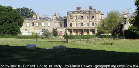
Birdsall House [Grade II* - NHLE 1316003]
Originally built c. 1600, its central core was remodelled in 1749 with further major additions in 1872 by the architect, Anthony Salvin
Stables [Grade II – NHLE 1174543]
Dating from the late 18th or early 19th century, they are next to the east wall of the former kitchen garden.
Old Ruined Church of All Hallows [Grade II – NHLE 1149108]
Original church for Birdsall dating from the 12th century. It was abandoned in the 1820s when a new church was built to the north. The remains now provide a feature in the parkland.
Icehouse
Located to the north of the largest fishpond at SE 816 651, it first appears on the 1st edition 6” OS map, surveyed in 1851.
Gardens and pleasure grounds
In 1730 there was a small garden area of just under ½ acre immediately south of the hall with Kell Beck Orchard and Gisderdale forming pleasure grounds of over 23 acres. By 1754, these grounds had increased to 50 acres, including the additional fishpond. Before the 1820s, the gardens to the south of the hall were removed and added to the pleasure grounds. After the new kitchen garden was built in 1873, the former garden north of the hall became a garden area.
Kitchen garden
The first walled (kitchen) gardens were south of the hall and in 1730 covered just over ½ acre each. Later described as the ‘High Garden’, a plan from c. 1761 (Figure 5) gives their layout. At this stage they were a mix of fruit, vegetables, shrubs and flowers with the latter planted on mounds. A second walled (kitchen) garden was added to the north (known as ‘Low Garden’) before 1761 (Figure 6). This was principally a productive area and it had two hot houses and hot beds for growing exotics such as pineapples, melons and grapes (NUSC Mi A 132/1). As was typical at the time, estate owners exchanged unusual plants with rough Cantaloupe melons from ‘Lord Falconbridges’ (probably Lord Fauconberg of Newburgh Priory) in 1766 and black pine plants from ‘Mr Lascelles’ in 1769 that may refer to one of the three brothers, Edwin of Harewood House, Daniel at Goldsborough Hall or Edward at Stapleton Park (ibid).
The extant kitchen garden was built in 1873, following the alterations to Birdsall House. A report from the Journal of Horticulture and Cottage Gardener (1 May 1879, 326-8) gives a detailed description of it:
‘The gardens, which are new, are about 600 yards from the mansion. A sunk fence divides them from the park on the south and east sides, and a wall separates them from the high road on the north and west. They comprise an area of eight acres, four of which in the centre are enclosed with a brick wall 12 feet high. The south aspect of the north wall is occupied by a fine range of glass houses arranged as follows – A corridor 320 feet long and 10 feet wide divided into four parts, two of which are devoted to the cultivation of peaches, and two are occupied by Camellias, Roses, Heliotropes, and Daphnes planted against the north wall. In front of the houses is a slate shelf for plants in pots. Under the walk…are the main pipes for the boilers for heating the span-roofed houses. These houses are placed at right angles to the corridor. Arrangements have been made for seven houses, and five have already been erected…In the centre is a conservatory 85 feet long, 30 feet wide, and 17 feet high…On each side of this house is a span-roofed vinery 75 feet long, 25 feet wide…
Beyond the vineries are place two forcing and plant houses each 75 feet long by 18 feet wide, and divided into three parts…Behind the north wall and opening into the corridor are a lean-to plant house, a fernery, a Mushroom house and potting sheds…At the northwest corner of the garden is a range of forcing pits five in number, 40 feet long and 10 to 8 feet wide…An Apricot shed occupies a space in the back yard 100 feet by 12 feet facing the east…On the north wall is a range of sheds, consisting of office, Grape room, fruit room…
The garden walks are of a sufficient width to admit carriages or carts…The enclosed garden is divided into four quarters with borders round the walls. Eight lines of espalier fences run across the garden from north to south, and are covered with dessert Pear and Apple trees. The slips of ground outside the inner garden are planted with fruit trees…[as are] the walls…
The whole has been laid out and constructed since 1873. The glasshouses, heating apparatus &c., were all erected by Messrs. Foster and Pearson, horticultural builders, Beeston, near Nottingham…The plan was by Mr. B. Wadds, his lordship’s present gardener’
The layout is shown in Figure 7 with the conservatory and apricot sheds illustrated in Figures 8 and 9. While the walls remain, the glasshouses are no longer extant.
Park and plantations
The Park
A small area of parkland was put in c. 1757 to the east of the hall and covered 8 acres. By the early 19th century, this had increased to over 30 acres with the addition of land to the south. By 1827, further areas had been incorporated into the parkland to the northeast (‘Up Garth’) and north (‘Woofers’), so by 1856, it was c. 85 acres. It was extended further in the late 19th century north of the new kitchen garden and by 1891, the parkland covered just over 112 acres.
Gisderdale/Crow Wood
This was originally part of the pleasure grounds of the early 18th century, with a path running through the centre of it. By the mid 19th century, it had been renamed as ‘Crow Wood’ and was about 10 acres.
Langhill Wood
The small section to the southwest of 5½ acres was the first to be planted probably in the 1760s, following the improvement plan. Another 7 acres in the northwest corner was in place by the 1820s with further planting in the 19th century to form a continuous area of 20 acres.
Bath Plantation
In place by the 1820s, this covered just over 7 acres.
Pitts Wood
Originally a small area of woodland (5 acres), it was expanded in the late 19th century to 29 acres just south of the new kitchen garden.
Water
Fish Ponds
The southernmost pond is rectangular and appears to be unchanged from the 1730 map. The middle pond was enlarged in the late 1750s to form another rectangle with the large pond to the north added at the same time.
Decoy Pond
Located at SE 822 643 to the southeast, it was probably put in between 1820 and 1850. It was a trap or cage decoy and by 1886, it had fallen out of use and was silted up (Payne-Gallway 1886, 187).
Books and articles
Cowell, F. 2009. Richard Woods (1715-1793): Master of the Pleasure Garden. Woodbridge, The Boydell Press.
Hall, I. 1979. Samuel Buck’s Yorkshire Sketchbook. Wakefield, Wakefield Historical Publications.
Henrey, B. 1986. No ordinary gardener, Thomas Knowlton 1691-1781. London, British Museum (Natural History).
Neave, D. and Turnbull, D. 1992. Landscaped Parks and Gardens of East Yorkshire. Georgian Society for East Yorkshire.
Payne-Gallway, R. 1886. The book of duck decoys, their construction, management, and history. London, Jan Van Voorst.
PRO 1825. Valor ecclesiasticus temp. Henry VIII, Vol V. London, HMSO.
PRO 1898. Calendar of the patent rolls, Edward I 1301-7. London, HMSO.
PRO 1903. Calendar of the charter rolls, Henry III 1226-57. London, HMSO.
PRO 1908a. Calendar of the patent rolls, Henry III 1216-72. London, HMSO.
PRO 1908b. Calendar of inquisitions post mortem, Edward II. London, HMSO.
PRO 1936. Calendar of the patent rolls, 1554-5. London, HMSO.
PRO 1939. Calendar of the patent rolls, 1557-8. London, HMSO.
PRO 1964. Calendar of the patent rolls, 1566-9. London, HMSO.
PRO 2009. Calendar of inquisitions post mortem, 1437-22. Woodbridge, The Boydell Press.
Roebuck, P. 1976. Constable of Everingham estate correspondence 1726-43. Leeds, Yorkshire Archaeological Society.
Sheahan, J. J. and Whellan, T. 1857. History and topography of the East Riding of Yorkshire v.2.
Beverley, John Green.
Surtees 1867. The survey of the county of York, taken by John de Kirkby. Durham, The Surtees
Society.
Surtees 1884. Testamenta Eboracensia, Volume 5. Durham, The Surtees Society.
Turnbull, D. and Wickham, L. 2022. Thomas White (c. 1736-1811): Redesigning the northern British landscape. Oxford, Windgather Press.
YAS 1887. Feet of Fines of the Tudor Period, Part 1. Leeds, Yorkshire Archaeological Society.
YAS 1891. YAS Record Series Vol. 12: Yorkshire inquisitions of the reigns of Henry III and Edward I, part 1 (1241-83). Leeds, Yorkshire Archaeological Society.
Primary sources
Hull History Centre (HHC)
UDDEV/60/86 Letter to Sir Marmaduke Constable from John Bede Potts, 27 February 1734
National Museums Liverpool: Maritime Archives and Library (NML)
D/EARLE/12/2/6 Lease for a year James White and Sir Watts Horton to Richard Coupland of property in Birdsall, Yorkshire, 17 May 1789
North Yorkshire Archives (NYA)
ZQH 7/45/3 Petition by Tobias Wickham, Dean of York versus Thomas Sotheby, 18 July 1695
Private Collection
A map of ‘Birdshall’, 1730
A plan of Birdsall House and its grounds, nd (c. 1757-60)
The National Archives (TNA)
IR 30/41/21 Tithe map of Birdsall, 1838
PROB 11/545/371 Will of John Lister, 29 June 1714
University of Nottingham Manuscripts and Special Collections (NUSC)
Mi A 132 Estate book 1756-71
f1 Work done in the gardens at Birdsall by Andrew Moffatt, 1761
f2 Work done in the gardens at Birdsall by Arthur Adamson, 1762
f23/24 Plans of low and high gardens
Mi Da 146/10 Plan of lands at Birdsall the property of Sir William Horton, 1774
Mi Da 149 Birdsall: surveys, 1754 & 1762
West Yorkshire Archives Services Leeds (WYASL)
WYL100/BL/A/3 Award in a dispute between Thomas Sotheby and Roger Thorpe (both of Birdsall) concerning enclosures made of common land, 16 October 1601.
WYL100/BL/A/13 Articles of agreement between Lord Irwin, William Wickham and Francis Thorpe to agree to enclose the open fields for better husbandry, 1665.
WYL100/BL/A/14 Award made by Commissioners for the enclosure of the unenclosed lands in Birdsall, 31 March 1692.
Maps
Ordnance Survey 6” 1st edition, surveyed 1851, published 1855
Ordnance Survey 25” 1st edition, surveyed 1891, published 1893
Figure 1 – Design of a building for Henry Willoughby from Treatise on Civil Architecture by William Chambers, 1759. Getty Library, public domain.
Figure 2 – Tithe map for Birdsall, 1838. © The National Archives.
Figure 3 – Birdsall House and grounds from Ordnance Survey 6” 1st edition, surveyed 1851, published 1855. National Library of Scotland CC-BY.
Figure 4 – Birdsall House and grounds from Ordnance Survey 25” 1st edition, surveyed 1891, published 1893. National Library of Scotland CC-BY.
Figure 5 – Plan of high garden next to Birdsall House c. 1761. Nottingham University Special Collections (Mi A 132 f24). Note north is to the bottom.
Figure 6 – Plan of low garden (walled kitchen garden) north of Birdsall House c. 1761. Nottingham University Special Collections (Mi A 132 f23). Note north is to the bottom.
Figure 7 – Layout of new kitchen garden from Ordnance Survey 25” 1st edition, surveyed 1891, published 1893. National Library of Scotland CC-BY.
Figure 8 – Conservatory at Birdsall from The Gardeners’ Chronicle, 2 February 1895. Public domain.
Figure 9 – Apricot shed at Birdsall from The Gardeners’ Chronicle, 2 February 1895. Public domain.


. Note north is to the bottom.")
 north of Birdsall House c. 1761. Nottingham University Special Collections (Mi A 132 f23). Note north is to the bottom.")


