Gardens and small area of woodland associated with Grade I listed manor house.
Estate owners
Since the 1170s, when the manor of Burton Agnes was held by Roger de Stutville, it has never been sold. It descended by marriage to the Griffith family, whose principal estate was in Staffordshire. In 1599 Henry Griffith was appointed to the Council of the North at York, providing the impetus to rebuild the old manor house on his Yorkshire estate at Burton Agnes. The present house was built between 1601 and 1610. Henry’s son, Sir Henry Griffith, died without heirs in 1654, and the estate passed to a nephew, Sir Francis Boynton of Barmston. The manor descended in the Boynton family until 1899 when it passed from Sir Henry Somerville Boynton to his daughter Cycely, who the same year married Thomas Lamplough Wickham, afterwards Wickham-Boynton. He died in 1942 and the estate passed to his second son Marcus. Marcus Wickham-Boynton died without issue in 1989, have established the Burton Agnes Hall Preservation Trust, and settled the Burton Agnes estate on Simon Cunliffe-Lister, who was descended from a branch of the Boynton family. (Allison (ed.) VCH Yorks ER II, 107-8; Neave & Neave, ‘Burton Agnes’, 37-9; Imrie, Manor Houses of Burton Agnes, 110-111)
The owners chiefly responsible for laying out or altering the gardens were:
Henry Griffith (d. 1620), who built Burton Agnes Hall 1601-10
Sir Griffith Boynton, 3rd Bart., owner 1695-1730
Sir Griffith Boynton, 6th Bart., owner 1761-1778
From the 1960s some formal elements were re-introduced by Marcus Wickham-Boynton. From 1990 Susan Cunliffe-Lister, on behalf of her son Simon Cunliffe-Lister, has undertaken a major redevelopment of the gardens.
Early history of the site
There has been a manor house at Burton Agnes since at least the late 12th century. No evidence for a medieval deer park has been found.
Chronological history of the designed landscape
17th century
Burton Agnes Hall was built during the first decade of the 17th century, and a formal garden commensurate in status with the new manor house would almost certainly have been laid out at this time.
Celia Fiennes, who was distantly related to the Boyntons, commented on the gardens at Burton Agnes when she visited the house during her tour of parts of northern England on horseback in 1697 (Griffiths, Diary of Celia Fiennes, 71-2):
We enter under a Gate house built with 4 large towers to a Court, which is large, in the middle is a Bowling green palisado’d round, and the Coaches runns round it to the Entrance which is by 10 stepps up to a Tarress, and thence a pav’d walke to the house, cut box and filleroy and lawrell about the Court…the Gardens are large and are capable of being made very fine, they now remaine in the old fashion. There is gravell walks and grass and Close walks, there is one walke all the length of the Garden called the Crooked Walke, of grass well cutt and rowled, it is indented in and out in corners, and so is the wall, which makes you thinke you are at the end off the walke severall tymes before you are, by means of the Codling hedge that is on the other side. This leads you to a Summer house that also opens to a large gravell walke that runns the breadth of the Garden to the house ward.
A section of the formal gardens in front on the hall are shown on Samuel Buck’s sketch of c. 1720.
18th and 19th centuries
The formal gardens, described by Celia Fiennes in 1697 as still ‘in the old fashion’, may have been replanned by Sir Griffith Boynton, 3rd Bart, who perhaps created a small park to the east; he was said in 1722 to have recently enclosed 85 a. of open field (28 a. from Middle Field, and 57 a. from East Field). (Allison, VCH Yorks ER II, 113)
Further improvements were probably the work of Sir Griffith Boynton, 6th Bart, who inherited in 1761. In 1766 the old road from the village to Rudston, which ran along the eastern boundary of the gardens, was diverted. A sunken ha-ha took its place along the stretch east of the hall, presumably to prevent stock straying from the parkland into the pleasure gardens. A painting by William Marlow (right) shows the east view of the hall from the park shortly after the ha-ha or retaining wall had replaced the sunken road. Further east ‘New Lane’ as it was still known in the 19th century (now Back Lane) was also part of the 18th- century changes to the landscape. (Allison, VCH Yorks ER II,106; Neave & Neave, ‘Burton Agnes Estate’, 41)
The woodland gardens north of the hall, formerly known as the Grove, were also part of the 18th-century improvements. A woodland walk, about a mile in length, was also laid out, in part along the route of the old sunken road to Rudston. (Neave & Neave, ‘Burton Agnes Estate’, 410)
In 1802 a visitor to Burton Agnes Hall, Dorothy Richardson, wrote an account of the gardens (JRL, English MS 1126). From the top of the gatehouse she described the view:
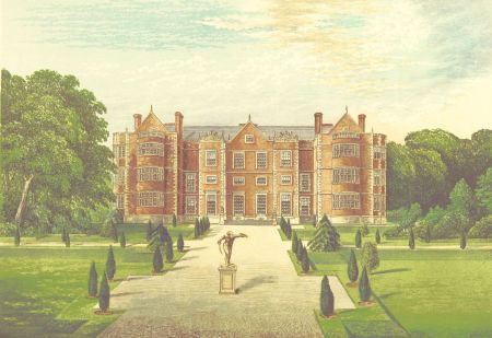
of the noble house to the north, on the opposite side of a very large square court with a background of a lawn richly adorned with wood…The court is very large having a wall to the west, with trees planted on the inside; and to the east (except near the house where it is separated from a lawn by a railing) a brick wall enclosing the inner garden which descends towards the south in steps with a coping & corbels, & has a flower border under it. In the centre of the court there is a large circular grass plat, with a small plot of gravel in the middle, upon which on a pedestal stands a stone statue of a gladiator. A broad carriage road surrounds the grass, & from thence a straight road with a grass plat on each side leads up to the House, before which there is a broad grass walk.
Describing the view from the east and north fronts of the hall, she wrote that these:
open upon a beautiful & extensive lawn, with many fine timber trees scattered upon it, particularly oak; & at some distance from the north front a grass terrace extends east & west with a background of trees, & from the centre of it a grass walk leads north to a small temple, with an open front to the south.
19th century
Teesdale’s map of Yorkshire, based on a survey of 1817-18 with some corrections before publication in 1828, suggests the parkland to the east may have been extended by this date. However, the mid 19th century OS plan, surveyed just before the enclosure of the rest of the open field land, shows the area of old enclosures (c. 130 acres) to the east of the formal gardens and woodland walk subdivided into fields or paddocks, rather than as open parkland. Later maps suggest the field boundary running east from the southern end of the narrow strip of woodland called the Walks to the Thornholme boundary represents the northern limit of what may be considered parkland.
The first plan to show the layout of the gardens in any detail is the OS plan published 1890. A formal avenue of trees runs from the gatehouse to the hall, with a statue about a third of the way along. A central path cuts across, providing access to the stables and other outbuildings located south-west of the hall. The kitchen gardens lie to the east. A small aviary is marked close to the kitchen garden boundary wall, with a larger aviary shown in gardens behind the hall, built by the 11th baronet. This aviary was created by the 11th baronet in the late 19th century to house the birds in ‘luxurious captivity’. (Imrie, Manor Houses of Burton Agnes, 98)
The gardens east of the hall are shown as subdivided into four lawned areas by rectangular paths, with trees planted in rows either side of the paths along three sides. Further north, behind the hall, the area east of the larger aviary is planted with trees; this planting continues beyond the boundary where a mixed plantation is also divided by paths. A less regular path runs from the kitchen garden area up to this area of woodland, leading into the long strip of woodland called ‘The Walks’. The temple referred to in 1801 is not marked.
The area between the hall gardens/woodland walk, and New Lane, divided into three closes on the mid 19th century plan, is shown as two closes, with clumps of trees in the southern close.
20th century
Marcus Wickham-Boynton inherited the estate in 1942. In the 1970s he employed the Bridlington architect Francis Johnson to design the rectangular ponds to the east of the house. Johnson also designed the garden house at the front of the hall, and in 1985 the swimming pool pavilion to the north-west, on the site of the aviary. (Neave & Neave, ‘Burton Agnes Estate’, 41)
Following the death of Marcus Wickham-Boynton in 1989, Susan Cunliffe-Lister took over management of the hall and gardens on behalf of her young son, Simon. She transformed the old walled kitchen garden, which by that date was mainly grass apart from a herbaceous border along the west wall, backed by shrub roses. Her ‘New Elizabethan Garden’ is a series of small gardens and includes a pottager, central herbaceous border, fruit border, jungle garden, campanula garden, coloured games garden and a maze. (Cunliffe-Lister, The Making of a New Elizabethan Garden)
Location
Burton Agnes Hall and its grounds lie on the north side of the A614, approximately 6 miles south-west of Bridlington and 35 miles east of York.
Area
The present area of gardens and parkland to the north enclosed by the Rudston Road and the Woodland Walks is 47.5 acres (19 ha). To this can be added the 61. 5 acres (25 ha) of land east of the gardens and north of the Bridlington Road that was shown as planted in a parklike manner with clumps of trees. This includes the field enclosed to the south and east by New Lane, and the fields directly east up to the boundary with Thornholme township.
In total the historic parkland and gardens at its greatest extent is 109 acres (44 ha).
Boundaries
The western boundary is the Rudston road. Woodland (The Walks) marks short stretches of the northern and eastern boundaries. From the southern end of the Walks the park boundary runs east to the township boundary between Burton Agnes and Thornholme, then south to the Bridlington road. The southern boundary of the parkland is the Bridlington Road and a small section of Back Lane; the gardens of Burton Agnes hall extend south to the green known as Maypole Hill.
Landform
The parkland and gardens lie towards the lowest edge of the south-eastern dip slope of the Wolds. The land rises south to north from 25m to over 45m AOD. The bedrock is chalk (Flamborough Chalk Formation) and the surface deposit is boulder clay (Till of the Devensian period).
Setting
Burton Agnes Hall and grounds lies in East Riding Landscape Character Assessment Area 19C North Holderness Open Farmland. An area dominated by open arable farmland which provides the setting for the parkland.
Entrances and approaches
The entrance to the hall and gardens is through the Elizabethan gatehouse, immediately north of Maypole Green, at the centre of the village of Burton Agnes.
Principal buildings
Burton Agnes Hall Listed Grade I
The hall, of red brick with stone dressings, three storeys high, was built 1601-10 by Sir Henry Griffith, probably to the designs of the leading architect Robert Smythson. It follows a traditional courtyard plan, with four ranges set round a small inner courtyard. The windows were altered by Sir Griffith Boynton in the early 18th century. (Pevsner & Neave, Yorkshire: York & ER, 367) The interior retains outstanding Elizabethan woodwork and plasterwork.
Gatehouse Listed Grade I
The three-storey embattled gatehouse, contemporary with the hall, is also built of red brick with stone dressings. It has four octagonal corner turrets. The coat of arms of James I is set above the central archway.
Norman manor house Listed Grade I
The original manor house stands to the west of Burton Agnes Hall, between the hall and the church. It was encased in brick in the early 18th century but retains a 12th-century vaulted undercroft with great hall above.
Stables Listed Grade II
New stables for the house, with accommodation for grooms and coachmen above, were built south-east of the hall in 1859.
Gardens and pleasure grounds
The garden area between the gatehouse and south front of the hall has retained the layout shown on the OS plan of 1890. An avenue of clipped yews runs down the central gravelled walk, with the statue of the discus thrower still in place. The lawned area to the east of the house now has the ponds which were introduced in the 1970s.
The woodland gardens to the north of the hall, first planted in the 18th century, survive. A path runs northwards through the gardens and up steps flanked by what appear to be wasters from the estate brickworks which flourished in the late 19th-early 20th century.
The woodland walk was newly planted in 1998. There are contemporary sculptures of birds, animals and insects, by Leonard Boydell, amongst the trees. (Neave & Neave. ‘Burton Agnes Estate’, 410)
Kitchen garden
The 19th century OS plan shows the large walled kitchen garden in its present location, south-east of the hall. In the early 20th century vegetables, fruit and flowers for the house were still grown here; there were two herbaceous borders and extensive greenhouses. Later in the century it developed as a market garden, but by the 1970s this had become uneconomical, and most of the area was laid to grass. The old kitchen garden is the location of the ‘New Elizabethan Garden’ laid out by Susan Cunfliffe Lister from c. 1980 onwards. (Cunliffe-Lister, Making of a New Elizabethan Garden, 1)
Park
The former parkland is now used as agricultural land, sometimes laid down to pasture but often ploughed up for arable crops. A few clumps of trees survive, particularly in the fields east of the woodland gardens and hall.
Books and articles
K.J. Allison (ed), Victoria County History, Yorkshire E. Riding, II, Oxford University Press, 1974
S. Cunliffe-Lister, The Making of a New Elizabethan Garden, Burton Agnes Hall Preservation Trust Limited, n.d.
E.W. Griffiths (ed.), Through England on a Side Saddle in the Time of William and Mary, being the Diary of Celia Fiennes, 1888.
I. Hall (ed.), Samuel Buck’s Yorkshire Sketchbook, 1979
M. Imrie, The Manor Houses of Burton Agnes and their Owners, 1993
D. and S. Neave, ‘The Burton Agnes Estate’, in Burton Constable, Sledmere & Burton Agnes Country House Estate Trail, Burton Constable Foundation 2007, 37-48
N. Pevsner & D. Neave, Buildings of England: Yorkshire, York and the East Riding, 1995
Primary sources
Hull History Centre (HCC), Wickham-Boynton of Burton Agnes Mss (WB)
John Rylands Library, University of Manchester (JRL), English MS 1126 - Dorothy Richardson’s Journal
Maps
T. Jefferys, Yorkshire, 1772 & 1776
R. Teesdale, Yorkshire, surveyed 1817-18, published 1828
Ordnance survey plans 1854-2012


, surveyed 1767-1770 & published in 1800. McMaster University Library, ref. RMC_4336 (CC BY-NC 2.5 CA)")


")
")