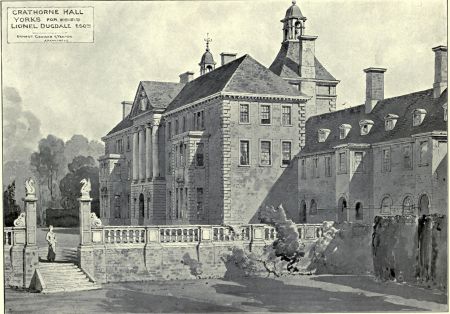
Although Crathorne Hall was built between 1903 and 1906, it sits in a much older designed landscape using the dramatic river Leven valley as its central feature. Designed by the noted architects, Ernest George and Alfred Yeates for Lionel Dugdale, Crathorne Hall was the largest country house of the Edwardian era to be built. George and Yeates also laid out the grounds around the hall but it was another leading garden designer, William Goldring, who provided the design for an intricate rose garden and the layout for the kitchen garden and neighbouring orchard.
Prior to the acquisition of the Crathorne estate by the Dugdale family in 1844, it had belonged to the Crathorne family since the early 14th century. By the mid-16th century, the Crathornes had a small manor house next to the church (south of the present hall) and had laid out a park of c. 300 acres on either side of the river. With their economic circumstances affected by their adherence to the Catholic faith and an interest in their other estate at East Ness in the East Riding, little altered at Crathorne until the turn of the 19th century. When the Dugdales acquired it, it served as a secondary residence mainly for sport until Lionel Dugdale decided to live there permanently in the 1890s and subsequently built a new residence.
Although the hall and immediate gardens were sold in 1977 and later became a hotel, the rest of the estate remains with the Dugdale family. The wider landscape, particularly the woodland, remain intact as do the pleasure grounds to the north of the hall. The rose garden has been grassed over and the sunken garden has been simplified but the designed landscape still provides the setting that George and Yeates envisioned for the hall.
Estate owners
In the early 13th century, the manor of Crathorne was held by Walter de Percy of Kildale and it remained with his descendants until John le Tyeler bought half the land from Arnold de Percy c. 1310. John’s son, William de Crathorne, bought a further share from William De Ayremynne in 1342 taking his landowning to 5 carucates by 1346. The estate continued with the Crathorne family until the death of Mary Tasbergh (her father was born George Crathorne) in 1844. It was then sold to James Dugdale on behalf of his nephews, Adam and Henry, with money from their father’s will. With the death of Henry Dugdale in 1869, his cousin, John (son of James) took over and it remains with his descendants, although the hall and grounds were sold off in 1977 and it is now a hotel.
Key owners responsible for major developments of the designed landscape and dates of their involvement:
William de Crathorne (c. 1316 – 46)
James Crathorne (1517 – 44)
Thomas Crathorne (1592 – 1639)
Ralph Crathorne (1714 – 55)
Thomas Crathorne (1797 – 1807)
James Lionel Dugdale (1881 – 1941)
Early history of the site
At the time of the Domesday book in 1086, Crathorne was described as waste with 5 carucates held by the King and 1 carucate by the Count of Mortain (the King’s half-brother). By c. 1204, these lands were in the possession of Walter de Percy of Kildale, who granted them to Roger Bagot of Crathorne (NYA ZEA 51). Walter’s descendant, Arnold, was confirmed as holding 6 carucates of land (c. 720a) in 1302-3 (PRO 1920, 133). Seven years later, Arnold sold 3 messuages and 3 carucates to John le Tyeler (VCH 1923, 234). Before 1328, he had also transferred land at Crathorne to either William de Ryther or his son, John, with latter passing possession to William de Ayremynne (Bishop of Norwich), Richard and Adam Ayremynne that year (YAS 1910, 6). The transfer included 12 messuages, 30 tofts (houses with land), one mill, 2½ carucates of arable land (c. 300a) and 12½ acres of meadow (ibid).
William de Ayremynne sold his holdings to William De Crathorne (John le Tyeler’s son) on 7 June 1342 (NYA ZEA 53). These consisted of 26 messuages, 20½ bovates of arable land (c. 308a), 18a meadow and 1 watermill in Crathorne (ibid). Four years later, William de Crathorne was confirmed to hold 5 carucates (600a), formerly held by Arnold Percy with the Rector of Crathorne holding 4 bovates (½ carucate), also formerly held by Arnold Percy (PRO 1920, 254). William’s descendant, John Crathorne, held the same land in 1428 (ibid, 305).
Apart from its extent, there is little information on the landscape at Crathorne until the 16th century, when an enclosed park stretching across the river Leven is shown on Saxton’s map of 1577 (Figure 1) and on the later Speed map of c. 1610. Both William de Percy in 1279/80 (VCH 1923, 236) and William de Ayremynne in 1331 (PRO 1912, 234) had been granted free warren for their lands in Crathorne but no reference has been found to a park being made by them. ‘Crathorne Park’ was subject to a special tithe payment of ‘£2 13s 4d or four marks’ per year (NYA ZEA 7), as was ‘Hunter Banks’ of 10s (ibid), indicating that this was also probably part of a deer park. When the tithes were assessed in 1844, these areas covered 146 and 150 acres respectively (NYA ZEA 31). ‘Hunter Bankes’ is mentioned in a deed of 1528 (NYA ZEA 62), so the park must have been in place then but whether it was created earlier than this is not known.
The park’s original extent would have included the 153a of land shown within the dotted line on a map c. 1802 (NYA ZEA 78) and listed in the survey of 1723 (NYA ZEA 77a). Parts of the later Hunter Banks Farm including two areas next to the river called ‘Horse Park’ and ‘Little Horse Park’ (5a 10p and 3a 2r respectively), Blackhill (46½ a), Little Black Moor (8¾ a), Lamb Closes (11¾ a) were probably part of it, as was Near North Holme (29¾ a) on the other side of the river (NYA ZEA 81). These give an area of about 296 acres and are shown on Figure 2. A deed of 1621 referred to ‘closes called the Old Park’ (NYA ZEA 64), suggesting that the owner, Thomas Crathorne, had reverted part of the park to farmland by this point. In 1717, Ralph Crathorne declared that his property at Crathorne amounted to ‘a capital messuage with barns &c, garths, and gardens, the park, containing one hundred acres’ (Atkinson 1890, 46).
In 1716, Ralph Crathorne was reshaping the landscape including the parkland, as he came to an agreement with the Church to enclose and take ‘into his Park at Crathorne a small parcel of ground at the north-west corner…containing about 2 ac and a Bank which is part of the glebe lands of the Rectory, for which he is willing to pay a yearly rent of 40s’ (NYA ZEA 10). Following his marriage to the heiress, Katherine Killingbeck, he sold her estates in 1723 raising £3,300 (NYA ZEA 76). This was partly to pay off debts but he also acquired the adjacent Low Foxton Farm in 1724 (Atkinson 1890, 90). A survey conducted in 1723 (NYA ZEA 77a) noted that the hall and its garth covered 4¼ acres and Crathorne Park 153¼ acres. By 1731, John Mayes of the Friarage near Yarm, was the tenant of the park (ibid).
Ralph then switched his attention to his other estate at East Ness in the East Riding. In his will written on 18 June 1752 (NYA ZEA 79), he specified that his brother and heir, James, was to ‘pay the necessary expenses in managing, beautifying, repairing, cultivating etc, the gardens and park at Ness with the green walks, gravel and other walks, fruit trees, vines and other trees, garden houses or pleasure houses...statues, ornaments, Fruit Walls, and other walls…as testator has done.’ On Ralph’s death in 1755, it was his nephew, Thomas, son of George Crathorne, who inherited his estates. During this period, there was little change to the landscape with most of the land continuing to be divided into farms in 1780 (NYA ZEA 81). Henry Ralph Crathorne had inherited it as a young child in 1764 but even on attaining his majority, there were little funds to develop the grounds as it was heavily mortgaged with £9,100 plus interest owing (ibid) in 1780.
By the time of the sale of the East Ness estate in 1782, the family had made Crathorne their main residence. The sale though did not help their finances and by 1791, the debt of Henry Crathorne to Sir William Scott was now £22,000 (NYA ZEA 107) and Crathorne was forced to appoint a receiver, Richard Wilson, for 99 years to collect the rents (ibid). While some restrictions on Catholics were being removed, they were still disbarred from public office and often their only source of income was from their landholdings. Henry Crathorne died in 1797 and the Crathorne estate went to his brother, Thomas, who managed to reduce the debt to £8,000 plus interest by his death in 1815 (NYA ZEA 120/1).
Thomas also made some modest changes with Graves noting in 1808 (112) that ‘the ancient residence of the Crathorne family is plain and modern, having been lately fitted up and repaired by the present proprietor, who now resides and is making considerable improvements upon his estate here’. This may refer to the additional plantations that were added prior to the sale of the estate in 1844. Most were next to existing plantations along the route of the river, as marked on a survey map of c. 1802 (NYA ZEA 78, Figure 3) that enabled a continuous wooded landscape either side of the river (Figure 4). Around the hall, the existing plantation (‘Crow Wood’) was extended to nearly 6 acres from just 2 acres (Nos 183 and 189 on Figure 5) with further small plantations to the southwest (181i, c. 0.1 acre) and southeast (150c, c. ½ acre).
Thomas Crathorne though left the estate to live in Stockton c. 1807 and the old hall was converted into 12 cottages in 1808 (Whellan 1856, 740). The estate passed to Thomas’ brother, George Tasbergh (né Crathorne) in 1815 and on George’s death in 1825 to his daughter, Mary. She and her husband continued to use the estate as collateral for mortgages, with the debt now £33,000 by 1842 (NYA ZEA 134). Following Mary Tasburgh’s death in 1844, the estate was put up for sale on the 23 October (NYA ZEA 138). It was bought by James Dugdale for his nephews, Adam and Henry, for £78,450 with money from their father’s estate that had been specified for this purpose (NYA ZEA 153/5).
When Adam came of age in 1849, he wanted a partition of estate between him and his brother. The land was split with the western section going to Adam and the eastern part to Henry (NYA ZEA 45). In 1853, Adam sold his share to James, his uncle. Henry’s share was sold in 1885 by his executors and was bought by Lionel Dugdale, grandson of James. By 1895, Lionel had moved to Crathorne with his new wife but stayed at Crathorne Grange (then called Crathorne Hall, Figure 6) to the northwest of the old hall.
Chronological history of the designed landscape
1903 – 1907
By 1903, Lionel Dugdale had decided to build a new house to the northeast, in the old park next to the river. He engaged the architects, Ernest George and Alfred Yeates, and they produced plans between July and November of that year (Grainger 1985, 306). The site was said to have been determined by George and his client using stepladders to assess the best views into the surrounding countryside (ibid, 309). This echoed late 18th century principles of placing the main building within a designed landscape with Grainger (2010, 167) observing that ‘the close relationship between house, garden and wider landscape were characteristic of George’. The area for the new hall had already been planted with conifers to the east by 1893, to add to the existing mixed woodland of Fox Hole Wood (Figure 7) and the woodland along the river remained from earlier plantations.
George probably determined the location of the kitchen garden to the northwest, the pleasure grounds including the ‘The Glade’ to the north and the gardens around the hall. The latter included a sunken garden next to the eastern section of the south or garden front and a rose garden to the west of the hall (Figure 8). While the sunken garden was probably to George’s design, the layout of the rose garden and the kitchen garden were done by William Goldring. He had trained at Kew and started his landscape design practice in the 1880s. By the time he was engaged at Crathorne, he was one of the leading designers of the day. He was noted for his formal style echoing the 17th century parterre such as his design for the British Pavilion at the St Louis Exhibition of 1904 (Figure 9) and where George and Yeates designed the building (The Gardeners’ Chronicle 12 March 1904, 168). The plan for the rose garden made in March 1905 (RIBA PA539/2 2, Figure 10) had similar symmetrical beds for the roses with more typical Edwardian hardy flower (herbaceous) borders to the north and south.
Goldring’s plan for the kitchen garden, made in November 1904, was largely practical with the standard four bed layout in the interior with a working area and orchard to the north (RIBA PA539/2 1, Figure 11). The drainage system indicated in the plan was in place by 6 January 1905 when payment was made for it (ZEA Ledger B, 1905-1908). The glasshouses, erected by W. Richardson & Co. at a cost of £918 15s (Grainger 1985, 310), were built soon afterwards. On 20th April, four tons of ‘sea gravel’ was ordered for the plant stands in the greenhouses, according to instructions from a ‘Miss Doré’ (ZEA Letterbook, 1903-1908). No further information has been found re the role of Miss Doré but she may have been advising Mrs Dugdale who requested samples of gravel to be sent to her earlier in April (ibid).
The rose garden was created in late 1905, as there was a payment for sods for it on 21 December (ZEA Ledger B, 1905-1908). When the pleasure grounds were put in is not certain although shrubs had been bought in 1905 from William Hedley costing £4 5s 9d (ibid). There was a larger order in the Hall account for 1907 with James Backhouse and William Strike supplying trees and shrubs to the value of £9 11s 7d and £35 1s 6d respectively, with an order for plants from Backhouse (ibid). These may have been for the sunken garden that was put in after June 1906, as it does not appear in a photograph taken by George and Yeates’ practice taken at that time (Historic England Archives BL19625 - https://historicengland.org.uk/images-books/photos/item/BL19625). The buildings were completed though and the Dugdales moved in.
Later history
Lionel Dugdale died in 1941 and the estate was inherited by his son, Thomas, who became the 1st Baron Crathorne in 1959. A leading politician and later diplomat, Crathorne became an important place for visitors and the grounds continued to be maintained until his death in 1977 (Figure 12). A description of the garden was published the following year (Lemmon, 68):
‘The 1ha (2½ acres) of kitchen garden still retains some of its former splendour in its greenhouse range and its espaliered apples in the orchard. Oaks, chestnuts and conifer woodland screen the house at the rear and a woodland and yew hedged walk takes the visitor to the pleasant open south-facing front garden and its views to the Cleveland Hills…From this path winding downhill to the river level another path goes through cherries behind a screen of oaks and shrub roses. The top path to the left leads down an imposing flight of stone steps to light woodland, planted with oaks, sycamores and round shaped Golden Yews…Below the nursery wing of the house is a sunken paved garden with a lily pool on the corners of which stand four bronze cherubs. From a central fountain bronze frogs spout streams of water. Formal beds in the paving are filled with dahlias and roses, while on the outer sloping borders the old fashioned flowers, Sweet Williams, sweet smelling stocks and Rock Roses…On the house walls are a fine old ‘Albertine’ rose, the climbing Hydrangea petiolaris and quince. From the daisy spangled lawn by the entrance courtyard at the rear of the house a Red Chestnut avenue leads from the house up the drive to the main road.’
On Thomas Dugdale’s death, the family decided to sell the hall and immediate grounds and it became the present hotel. Although the rose garden has been removed and the sunken garden layout simplified, the designed landscape remains a suitable setting for Crathorne Hall.
Location
Crathorne Hall is 0.5 miles (1km) north of Crathorne village and 3 miles (5km) southeast of Yarm.
Area
The historic designed landscape associated with Crathorne Hall covered c. 300 acres (c. 120 ha) at its greatest extent.
Boundaries
The northern boundary is formed by the northern edge of Weary Bank Wood from NZ 445 094 to the road from Yarm, when it follows the course of the river Leven to Foxton Bridge. It then continues eastwards along the northern extent of Foxton Wood to NZ 464 092. The eastern boundary is formed by the woodland lining the river as it heads south as far as Crathorne Mill. The short southern boundary runs along the village road from NZ 444 075 to just south of the Catholic chapel. The western boundary starts at the southern extent of Crow Wood and follows it north until it reaches the road by the Crathorne Arms. It then follows the road past the gate lodge to NZ 441 083 when it turns east past Five Houses and the northern extent of the pleasure grounds to Coalpit Wood and north along the western edge of North Holme Wood to NZ 445 094.
Landform
The underlying geology is Sherwood Sandstone Group overlain with deposits of clay, sand and gravel. The soil across the estate is seasonally wet and slightly acid base-rich loam and clay with impeded drainage and moderate fertility.
Setting
Crathorne Hall lies in the Landscape Character Area of the Leven Valley that is mainly large-scale intensive arable farming with the river Leven, surrounded by mature woodland, running through it. The Hall lies at 57m AOD with the land falling away sharply to the south and east to the river at 35 - 37m OD. The pleasure grounds to the north of the hall rise steadily to 64m OD before levelling off and slightly falling to 60m OD. The ground to the west is relatively flat at between 56m and 61m OD.
Entrances and Approaches
Lodge [Grade II – NHLE 1188675]
Built c. 1904 by Ernest George, it is southwest of the hall and it forms the entrance off main road from Crathorne village. A carriageway from it goes northeast to the stables and the rear of hall.
Principle Buildings
Crathorne Hall [Grade II* - NHLE 1294649]
Built between 1903 and 1906 for James Lionel Dugdale by Ernest George and Alfred Yeates.
Stables [Grade II – NHLE 1150271]
Built between 1903 and 1906 for James Lionel Dugdale by Ernest George and Alfred Yeates.
Old Hall [Grade II – NHLE 1150266]
There is mention of a messuage in a document of 1506 that may refer to the site (NYA ZEA 61), however the building is 17th century and is first noted as the ‘capital messuage or manor house of Crathorne’ in 1672 (NYA ZEA 70). It was remodelled by Thomas Crathorne before 1807, before being converted into 12 cottages in 1808 (Whellan 1856, 740). This was reduced to four dwellings in 1935.
Gardens and pleasure grounds
Sunken garden
Probably designed by Ernest George, it was constructed c. 1907. The layout in a Country Life article from 1911 showed formal beds with two or possibly three central features. In the centre was a lily pool that remains although the rest of the layout has been simplified with flower beds only on the eastern side.
Rose garden
Built next to the western wing of the hall, the rose garden was designed by William Goldring in 1905 and completed that year. The design (Figure 10) comprised of two symmetrical areas north and south with rose beds cut into a lawn. Between the two areas was a path leading out in the western pleasure grounds via some steps. At the northern and southern edges were two hardy flower borders and the whole area was surrounded by a hedge with trees to provide a screen. The area is now grassed over.
Pleasure grounds
To the north was ‘The Glade’ covering just over 3 acres with a central wide path running north to south. A twin avenue of trees was added before 1964 (Figure 12). To the west beyond the rose garden and north of the bastion style wall, was another pleasure ground of c. ¾ acre.
Kitchen garden
Started in 1904 and completed the following year, the walled area covered c. 1⅓ acres with the orchard and buildings to the north a further 1¾ acres. While George determined the location and probably overall size, the interior was designed by William Goldring (Figure 11). The four central beds for rotated crops had a fountain in the centre with espalier apples and pears running along the central section west to east and hardy flower borders from north to south.
Along the northern wall were a range of glasshouses supplied by Richardson & Co that had from west to east: carnation and stove houses, peach house and vinery, conservatory, vinery and peach house and two greenhouses. Behind these were the garden buildings and electric light sheds and in front of the peach houses and vineries two outside borders, possibly for exotic or subtropical plants. At the southwest corner, there was small garden house and to the northwest of the walled area, the Gardener’s House and Bothy. In the orchard area were 4 large areas to grow vegetables plus asparagus beds. The fruit trees were arranged in five rows with gooseberries, currants and raspberries planted in between. By 1913, a small glazed building (frame) had been put in the western section of the vegetable ground.
Park and plantations
Crathorne Park
The exact date of Crathorne Park’s construction is uncertain but was before 1528. Straddling the river north from the old hall, it covered just under 300 acres (Figure 2). By 1717, it had reduced to about 100 acres with just the land next to the river. It remained as a marked feature until the 1840s as a special tithe payment was in place for it and Hunter Banks. Part of its woodland was later incorporated into the grounds for the new Crathorne Hall.
Old Hall Wood/Crow Wood/Gooseholme Wood
Listed on the 1780 survey, this area of woodland covered nearly 7 acres and formed a shelterbelt around the north of the hall. The Old Hall Wood was extended in the early nineteenth century to the east and south and is extant.
Park Wood/Hunter Banks Wood/Eller Wood/Foxton Wood
These formed a continuous area of woodland along the eastern bank of the river, with some sections listed in the 1780 survey: ‘Wood east of the river’, 18a 2r 21p, ‘Part of West Wood’ (later Park Wood), 3a 2 12p and ‘Eller Wood’, 15a 1r 2p. More plantations were added in the early 19th century (Figure 4). By 1848, they covered just under 58 acres (NYA ZEA 138) and are still in place.
Fox Hole Wood/Coalpit Wood/North Holme Wood/Weary Bank Wood
On the western bank, the woodland by 1780 included ‘Wood west of the river’ (later Fox Hole Wood), 11a 1r 26p and ‘Narrowholme Bank’, 3a 3r to the north. They were joined up with more planting to make a continuous area of c. 35 acres in the early nineteenth century and are extant.
Books and articles
Anon 1911. Crathorne Hall, Yorkshire, the seat of Mr. Lionel Dugdale. Country Life, 29 April, 598-604.
Atkinson, J. C. ed. 1890. Quarter Sessions Records Volume 8. London, The North Riding Record Society.
Grainger, H. J. 1985. The architecture of Sir Ernest George and his partners, c. 1860-1922. PhD thesis, University of Leeds.
Grainger, H. J. 2010. Crathorne Hall: The Making of an Edwardian Landscape in Northern Landscapes: Representations and Realities of North-East England. Woodbridge, Boydell Press.
Graves, J. 1808. The History of Cleveland. Carlisle, F. Jollie and Sons.
Lemmon, K. 1978. The Gardens of Britain 5: Yorkshire and Humberside. London, B. T. Batsford Ltd.
PRO 1912. Calendar of Charter Rolls 1327-41. London, HMSO.
PRO 1920. Inquisitions and assessments relating to feudal aids; with other analogous documents preserved in the Public Record Office. A.D. 1284-1431. London, HMSO.
Whellan, T. and Co. 1859. History and topography of the city of York; and the North riding of Yorkshire, Volume 2. Beverley, John Green.
VCH 1923. A History of the County of York North Riding: Volume 2. London, St. Catherine Press.
YAS 1910. Feet of fines for the county of York, from 1327 to 1347, Record Series Vol. 42. Leeds, Yorkshire Archaeological Society.
Primary sources
North Yorkshire Archives (NYA)
ZEA
7 Terrier of Crathorne, 8 August 1715
10 Articles of agreement between Ralph Crathorne and James Peirson, Rector of Crathorne, 9 November 1716
31 Award of the tithes of Crathorne, 1844
45 Abstract of the title of the trustees of Henry Dugdale to the advowson of Crathorne, 1870
51 Charter from Walter de Percy to Roger Bagot granting land at Crathorne, c. 1204
53 Transfer of land at Crathorne from William de Ayremynne to William de Crathorne, 7 June 1342
61 Deed poll by Thomas Crathorne that Fairfaxes and Beilby stand seised of property in Crathorne, 28 November 1506
64 Settlement in contemplation of marriage of Ralph Crathorne and Marie Wreight, 29 March 1621
76 Agreement between Ralph Crathorne and Robert Dolman, William Wakefield and John Poole re his wife’s inheritance, 28 January 1723
77a A terrier/survey book of the lordship of Crathorne, the estate of Ralph Crathorne drawn from 1723 survey
78 Plan – survey of an estate belonging to Thos. Crathorne at Crathorne, 1802
79 Copy of the will of Ralph Crathorne made 18 June 1752
81 A terrier of the Iordship of Crathorne, belonging to Henry Crathorne. Valued & surveyed in 1780
81a Plans from terrier of the Iordship of Crathorne, belonging to Henry Crathorne. Valued & surveyed in 1780
107 Detail of Henry Ralph Crathorne’s debt to Sir William Scott, 27 December 1791
120/1 Transfer of mortgage from Sir William Scott following payments by Henry Crathorne, 26/7 January 1818
134 Further charge on mortgage taken out by Mary Tasburgh, 10 May 1842
138 Sale particulars of Crathorne Estate, 23 October 1844
153 Abstract of reconveyance of the manors and estates at Crathorne, Hutton and Kirkleavington, 2 April 1846
155 Declaration of trusts by the trustees of William Dugdale’s will, 2 April 1846
155c Sale particulars of the Crathorne estate, July 1885
156 Map of Crathorne estate showing proposed division, 1850
Crathorne Estate: Ledger B, 1905-1908
Ledger C ‘Cash book’, 1901-1909
Letter book, 1903-1908
RIBA Archives (RIBA)
PA539/2(1-2) Designs for the gardens, Crathorne Hall, Yarm, North Yorkshire, for Lionel Dugdale, by William Goldring, Nov 1904 – Mar 1905: Plan for kitchen garden and orchard and revised plan for rose garden
Maps
Christopher Saxton’s map of Yorkshire, 1577 (reprint 1732). David Rumsey Historical Map Collection, David Rumsey Map Center, Stanford Libraries, 13539.025. CC BY-NC-SA 3.0
John Speed’s map of the North and East Riding of Yorkshire, c. 1611. Cambridge University Digital Library, Atlas.2.61.1
1st edition Ordnance Survey 6” map surveyed 1854, published 1857
1st edition Ordnance Survey 25” map surveyed 1893, published 1894
Revised edition Ordnance Survey 25” map revised 1913, published 1914
Revised 1:2500 Ordnance Survey map, revised 1964 and published 1965
Figure 1 – Crathorne Park on Saxton’s map of Yorkshire, 1577 (reprint 1732). David Rumsey Historical Map Collection, David Rumsey Map Center, Stanford Libraries, 13539.025. CC BY-NC-SA 3.0.
Figure 2 – Crathorne Park and Hunter Banks areas subject to special tithe on plan of an estate belonging to Thos. Crathorne at Crathorne, 1802 (North Yorkshire Archives ZEA 78).
Figure 3 – Woodland marked as ‘in hand’ in 1780 survey on plan of an estate belonging to Thos. Crathorne at Crathorne, 1802 (North Yorkshire Archives ZEA 78)
Figure 4 – Areas of woodland bordering either side of river on 1st edition Ordnance Survey 6” map surveyed 1854, published 1857. National Library of Scotland CC-BY.
Figure 5 – Woodland around the old hall, 1844 (North Yorkshire Archives ZEA 138).
Figure 6 – Crathorne Grange (Hall) on 1st edition Ordnance Survey 25” map surveyed 1893, published 1894. National Library of Scotland CC-BY.
Figure 7 – Site of later Crathorne Hall on 1st edition Ordnance Survey 25” map surveyed 1893, published 1894. National Library of Scotland CC-BY.
Figure 8 – Crathorne Hall and immediate grounds on revised edition Ordnance Survey 25” map revised 1913, published 1914. National Library of Scotland CC-BY.
Figure 9 – Layout of the garden next to the British Pavilion at St Louis Exhibition 1904 by William Goldring. The Gardeners’ Chronicle, 12 March 1904 supplement.
Figure 10 – Revised plan for the rose garden at Crathorne Hall by William Goldring, March 1905. RIBA Collections PA539/2 2
Figure 11 – Plan for the kitchen garden and orchard at Crathorne Hall by William Goldring, November 1904. RIBA Collections PA539/2 1
Figure 12 – Crathorne Hall and immediate grounds on revised edition Ordnance Survey 1:2500 map revised 1964, published 1965. National Library of Scotland CC-BY.
. David Rumsey Historical Map Collection, David Rumsey Map Center, Stanford Libraries, 13539.025. CC BY-NC-SA 3.0.")
.")
")

.")
 on 1st edition Ordnance Survey 25” map surveyed 1893, published 1894. National Library of Scotland CC-BY.")


