The Brooksbank family of Elland and Hackney bought the manor of Healaugh in 1714. Given the decline of the Elizabethan manor house (Healaugh Manor) on the former monastic site of Healaugh Park Priory and its associated deer park, they built a new house, Healaugh Hall. It was later also known as Healaugh Manor. The three-storey mansion built in 1785 was designed by John Carr, but has not been formally recognised as his work.
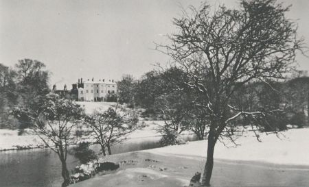
It was sited in a prime location on the north bank of the River Wharfe, where gardens and pleasure grounds within parkland were laid out in the late eighteenth century (Figure 1). No evidence of a garden designer has come to light. On the south bank was a small deer park, which was linked via a wooden bridge, carrying a carriageway to the Wetherby to Tadcaster road. The house was demolished in 1947 and the remaining service buildings converted to residential use.
Estate owners
Joseph Brooksbank (1654-1726) of Elland and Hackney bought the manor of Healaugh in 1714 and the family owned the manor and estate until 1961 (Seals, 1969). They were prosperous merchants and bankers. His son Stamp Brooksbank (1694-1756) was a Member of Parliament and Governor of the Bank of England and built the grand Palladian Hackney House in 1732.
Stamp’s grandson, Benjamin Brooksbank JP (1757-1842) inherited the manor of Healaugh and moved to Yorkshire when he married Philippa Clitherow (or Clitheroe) in 1782, daughter and coheir of Colonel James Clitherow of Boston House. For a time they stayed at Healaugh Old Hall in the village, then rented a house named Little Askham in Askham Richard, Yorkshire. By 1785 they had built a Georgian mansion house, Healaugh Hall, sited by the River Wharfe, northwest of Tadcaster, where they laid out gardens and small parkland. They created a deer park on the opposite riverbank, as part of the designed landscape (Figure 2). The diary of Philippa Brooksbank written between 1781 and 1832 and transcribed by Kerry Brooksbank in 2006 (WYAS WYL68/37C) provides some of this detail. It focuses on family social events and visits, but does give some record of the development of the house and gardens. It reveals Philippa and Benjamin’s wide social circle, including John Carr, Lady Harewood, Lady and Lord Hawke of Scarthingwell Hall, Lady and Lord Howden of Grimston Park, the Fairfax family at Newton Kyme, Stapletons of Wighill, Bethells of Rise Park, Wentworths of Toulston Lodge and Fawkes family of Farnley Hall.
Benjamin’s eldest son Stamp Brooksbank (1784-1856) inherited Healaugh Hall estate. He married Ann Hunter, daughter and coheir of John Hunter of Medomsley and The Hermitage, Hexham, but they had no heirs. Stamp’s brother, Reverend Edward Hawke Brooksbank (1789-1883), Vicar of Tickhill and later of Healaugh, inherited Healaugh Hall. He had previously lived at the former Brooksbank family home Old Hall, sited in Healaugh village, where he had extended the house and carried out improvements to the village.
His son, Edward Brooksbank (1827-1919), barrister and JP and then his grandson Sir Edward Clitherow Brooksbank 1st Baronet (1858-1943) inherited the estate. The latter married Dame Katherine Graham Lang, daughter of Hugh Morris Lang of Selkirk and they were the last owners of the estate, which was sold in 1961, thus ending a 250-year connection to the Brooksbank family (Seals 1969, Appendix D).
Key owner responsible for major development of the designed landscape and dates of their involvement:
Benjamin Brooksbank – owner 1785 – 1842
Early history of the site
Joseph Brooksbank, a prosperous London merchant, first leased the manor of Healaugh in 1711 and then purchased it in 1714 for £9,495, to provide funds to Thomas, Lord Wharton and First Baron, who was in need of money to endow his daughters. By this time the Elizabethan manor house (Healaugh Manor) that Lord Wharton had built, on the former monastic site of Healaugh Park Priory, was in ruins and parts were rented out as farm buildings. The manor included the former deer park, Healaugh Park, which was transformed in the late sixteenth and seventeenth centuries, to create a smaller park ‘Knitter Park’. By 1757 the latter had reverted back to arable cultivation rather than parkland (Boutwood 2016, 16).
By 1718 Joseph built a new manor house locating it in a more elevated position in Healaugh village, adjacent to the former site of Hall Garth. It was where the family stayed on their visits from London, enjoying country life. Francis White’s 1785 map depicts a house named ‘High Ashes’ at the northern end of the village (Figure 1). It was renamed ‘Old Hall’ when the new house, Healaugh Hall, was built on the banks of the River Wharfe. Its name changed over time, referred to as ‘The Hall’ (1841 census), Healaugh Hall (1851-1881 census) and then recorded as Healaugh Manor (1891 census). This reflected the changing seat of the lord of manor of Healaugh, moving from the former priory site to Healaugh village, then to the River Wharfe location, as the properties were passed down through several generations of the Brooksbank family.
The site for the new house that Benjamin Brooksbank chose by the River Wharfe extended across three parishes, Wighill and Healaugh on the north bank and Tadcaster West on the south bank. The area around the hall was formerly part of arable fields and medieval ridge and furrow ploughing still survives across the parkland. The family owned land on the opposite bank, which became part of the designed landscape, used as deer park. It was formerly named ‘Burdining Field’ (WYAS 2002, archaeological site number 48) (see 4.10.1).
Chronological history of the designed landscape
When Benjamin Brooksbank and his wife Philippa came to Yorkshire the architect John Carr was part of their social circle of friends. He designed a three-storied Georgian mansion for them, Healaugh Hall, which was completed by 1785 (Figure 3). They chose a site overlooking the River Wharfe, northwest of Tadcaster, siting the house on a terrace above the floodplain of the river. Here there was space to create gardens and small parkland and take advantage of the river views and frontage (Figure 4). No evidence of a garden designer has come to light. They may well have designed the garden themselves. Benjamin designed and built a wooden bridge and carriageway to link the house and gardens with the deer park they created on the opposite riverbank (Figure 5). It also gave access to the main road between Tadcaster and Boston Spa on to Wetherby.
The Brooksbank family archive (WYAS WYL68) reveals information about the manor of Healaugh, but contains little about Healaugh Hall and its designed landscape. The main source of evidence for the layout and development of the gardens and parkland are Francis White’s 1785 map (Figure 1), historic estate plans (WYAS WYL68/66 & WYL68/67) and the 1849 6” Ordnance Survey map (Figure 2).
The house had attached west and north ranges with offices and garages. To the north were outbuildings and the stable block leading to a drive. In the year that the house was completed, Francis White’s 1785 map shows the house and stables with a walled garden to the northwest and a triangular area of gardens to the west. The 1790 estate plan (WYAS WYL68/66) shows an orchard on the north side of the walled garden with gardens surrounding the house. These were set within parkland containing clumps of trees and narrow tree belts, where by 1815 (WYAS WYL68/67) an oval ornamental pond was dug. By 1849 the gardens surrounding the house have been enlarged and developed as pleasure grounds with a conservatory, walks and an icehouse. To the east the parkland was fringed by narrow shelterbelts and a curved drive extended to Wighill Lane (Figure 6). Later Ordnance Survey maps show little change, except the buildings to the north of the house increase, including a home farm. In the wider landscape to the east of the parkland, a house named Fircroft was built and set within a small parkland by 1906 (Figure 7).
Later History
The house had two fires, one in 1901 (Yorkshire Post and Leeds Intelligencer, 22 July 1901) and a more serious one in 1915 (Yorkshire Evening Post, 16 June 1915). During the Second World War the army used the house and grounds (Seals 1969).
When Sir Edward Clitherow Brooksbank owned the house, the gardens were open to the public on several occasions to raise money for charity and the events were advertised in the local newspapers:
Yorkshire Evening Post, 22 Jun 1933 – The gardens of Healaugh (home of Sir Edward Brooksbank) will be open to the public on Saturday 24 June from 11 am
Yorkshire Evening Post, 7 May 1934 – A midsummers nights dream organised by Sir Edward Brooksbank in the gardens of his home
Yorkshire Post and Leeds Intelligencer, 22 June 1934 – Open garden 2-6.30 pm in aid of Yorkshire Personal Service League
Yorkshire Post and Leeds Intelligencer, 6 June 1936 – Garden Fete at Healaugh Manor, 2-10pm, military band, unique attractions, admission 6d, 3d after 5pm, proceeds to Archbishops Appeal Fund
Healaugh Manor was put up for sale in July 1944 (Yorkshire Post and Leeds Intelligencer, 25 July 1944) and demolished by 1947 and the family moved to Menethorpe Hall near Malton. The residue of the estate was sold in 1961. The service wing and remaining buildings were converted into residences. Some used and expanded as a farm and the parkland reverted to pasture.
Location
Healaugh Hall, its gardens and parkland, lies 1.8 km (1 mile) northwest of Tadcaster, along Wighill Lane, on the north bank of the River Wharfe in the civil parish of Healaugh (Figure 1). Its associated deer park lies on the south bank of the river in the civil parish of Tadcaster.
Area
The area of the former house, gardens and parkland on the north side of the river, including the floodplain and river frontage is 26 hectares (64 acres) and the deer park on the south bank is 20 hectares (49 acres), totalling 46 hectares (113.5 acres).
Boundaries
The River Wharfe bisects the estate and has substantial flood defence banks, especially on its northern bank. The northern part of the parkland surrounding the house and gardens is centred at SE 4798 4437, enclosed on three sides by a stone wall. The western boundary extends north from the river at SE 4750 4425 to SE 4790 4464. The northern boundary is aligned along Wighill Lane, turning southwest at SE 4838 4425 to meet the river, which forms the southern boundary.
The parkland and former deer park on the southern bank of the River Wharfe forms a triangular area, centred at SE 4788 4398. The river lies on its northern side, a field boundary on its eastern side, the Wetherby to Tadcaster road (A659) on its southern side, turning northwest at a disused limestone quarry, then back to the river. Part of a substantial stone wall survives on its southern side.
Landform
The site of Healaugh Hall lies at 20m above AOD on a river terrace, separated by a steep bluff line sloping down to the floodplain at 5m above AOD by the River Wharfe. There are natural springs along the slope. The 1894 Ordnance Survey map (Figure 6) labels areas liable to floods by the river, despite the construction of flood banks. This corridor flanking the river is overlain with alluvium, producing freely draining floodplain soils. The underlying geology across the northern part of the parkland is calcareous mudstone (Croxby Formation), overlain by glacial tills and part of the Escrick Moraine, creating undulating topography and hummocky terrain, rising to 24m in the parkland. Here the slightly acid, loamy and clayey soils have impeded drainage, used today for pasture and some arable. On the south bank of the Wharfe the area of parkland of the former deer park rises to 30m at Kelcbar Hill. The underlying geology is dolomitic limestone (Brotherton Formation), which gives rise to freely draining lime-rich loamy soils, used today for arable and pasture (Number 5 Soilscape: Cranfield University 2016, British Geological Survey 2016).
Setting
Healaugh Hall and parkland is in a prime location on the north bank of the River Wharfe. The house, now demolished, sat in a prominent elevated position visible from the opposite riverbank (Figure 4). Its surviving parkland trees are important, as the river corridor is devoid of woodland, except for that associated with historic parklands, such as Newton Kyme Hall 1.5km further upstream and Grimston Park 3km downstream.
The parkland and gardens were laid out on top of medieval ridge and furrow ploughing, which still survives today. There is evidence of earlier field systems within the deer park and some Iron Age and Roman rectilinear enclosures are revealed as cropmarks (NRHE: 1199293). Recent lidar 1m digital surface model images (https://data.gov.uk/publisher/environment-agency accessed 20/05/17) show surviving earthwork banks of a field system of uncertain date.
Former gravel pits and quarries also lie within the deer park. The limestone was an important resource quarried for building stone and the disused Smaws Quarry abuts the southwest boundary, but it is uncertain when it was first in use (Figure 7).
An eleven arch railway viaduct spans the River Wharfe and is an imposing structure visible from the banks of the River Wharfe. It was constructed circa 1846-9 for a rail link between York and Leeds, but was never implemented. Instead it provided a goods siding line for a local mill until 1955 and is now listed Grade II [NHLE: 1167141].
Entrances and approaches
Three entrances and drives/ carriageways are clearly seen on the 1849 Ordnance Survey map. An entrance on Wighill Lane, probably the main one, has two stone gate piers surviving, inscribed ‘Healaugh Manor’. A curving drive ran westwards to reach the north side of the house with a turning circle. The surviving embanked carriageway is now a farm track aligned with a field boundary.
Another entrance further northwest on Wighill Lane gave access to the estate stables and farm complex, which were north of the house. It is in use today as the main access route to the farm and converted residences now developed on the site.
There was a branch at this entrance forming a carriageway down the western perimeter of the estate to the River Wharfe. A wooden bridge gave access to the parkland and deer park on the south bank (Figure 5). Although the bridge is demolished the substantial stone abutment on the south bank of the river still survives (Figure 8). From the bridge a carriageway ran through a stone revetted cutting, then across the deer park to another stone walled cutting, as it descended to the third entrance on the Tadcaster to Wetherby road (now A659) (Figures 9a & 9b).
No lodges appear at the entrances but by 1891 (Figure 6) a building at the more northerly entrance, possibly served as a lodge. By 1963 (OS 1:2500 map) the building is named ‘Healaugh Manor Cottage’, which it remains today, but it appears rebuilt.
Principal buildings
Healaugh Hall (also known as Healaugh Manor)
Healaugh Hall was built by 1785, but is now demolished. John Carr designed the building, but it has not been acknowledged in any published lists of his architectural work (Wragg 2000, 103). It was noted that family tradition linked John Carr with the design (Waterson and Meadows 1998, 18). A transcription of Philippa Brooksbank’s diary does provide explicit primary documentary evidence. The design also compares well with other buildings recognised as Carr’s commissions. The house named Healaugh Hall was also known as Healaugh Manor. Philippa calls the house Healaugh Manor in 1785, but it is not recognised by that name by the Ordnance Survey until 1891 and in Census records until 1894.
Philippa’s diary records visits from Mr Carr, who is part of their social circle from the time they arrived in Yorkshire in June 1782. She also notes visits to Mr Carr in York. Entries record Mr Carr and Mr Lang visiting their house at Askham Richard on several occasions. Philippa describes Mr Lang as a steward. He is possibly Robert Lang, who is noted as the surveyor for the Brooksbank’s estate in 1757 (WYAS WYL68/12) and 1760 (WYAS WYL68/5). Work on the house began on 30 March 1784 and Philippa notes visits to the site as the house building progressed and its completion by July 1785, when the family moved in. The entries relating to the building of the house and Mr Carr, which is interpreted as John Carr are:
17 June 1782 – Mr Carr rode to Healaugh with us and dined with us at Tadcaster
19 July 1782 – to York to see Mr Carr
15 August 1782 – walked a good deal with my husband looking for a situation to build a house
15 June 1783 – Mr Carr and Mr Lang called and dined re new house
21 June 1783 – took a drive to look at situation for a new house. Many social calls Mr Carr & Mr Lang
29 June 1783 – Mr Carr and Mr Lang drove to building ground
30 Aug 1783 – looked at new house on way back from Newton Kyme
18 May 1784 – the stables and offices and kitchen garden was built before the house, that was begun the day before my little boy [Stamp] was born [31 Mar 1784]
11 Aug 1784 – Good husband was very eager to look after his new house building, we frequently went to see the works
16 Jul 1785 – All the family moved to Healaugh Manor
The house was a three-storey Georgian mansion, seven bays wide with three central bays forming a full height canted bay, which is a characteristic design of many of John Carr’s buildings (Figure 3). The rear had a pediment and porch entrance. It had an extended service wing on the west side. A close parallel in architectural style is Aston Hall (also known as Aughton Court), near Rotherham, which was built by 1772 to John Carr’s designs and is a listed Grade II* building (NHLE: 1314660, Images of England: 335896). Its exterior has more embellishment than Healaugh Hall, but the similarities in design and layout are striking.
An advert for the sale of Healaugh Manor in the Yorkshire Post and Leeds Intelligencer dated 12th August 1944 describes the house in its garden and parkland setting:
Healaugh Manor of Georgian Architecture, its gardens and parklands extending to 46 acres, with considerable frontage to the river Wharfe and much valuable timber. The accommodation which is mostly arranged on two floors, includes: entrance hall, drawing room, dining room, library, smoke room, gun room, cloakroom, 5 principal bedrooms, 2 dressing-rooms, 3 bathrooms, 8 secondary bedrooms, butler’s pantry, kitchen scullery, dairy, wash-house, stables and garages. Well stocked walled garden and glasshouses.
Conservatory (or greenhouse)
A detached building is depicted on the 1849 Ordnance Survey map west of the house at SE 4791 4440. It has an unusual shape with an angular stepped facade on the north side and it is quite large, at least 20m in length (Figure 10). Its position within pleasure grounds, overlooking a lawn with a sundial, suggests it is a conservatory (or greenhouse). Philippa Brooksbank’s diary records a small pond for goldfish was made adjacent to the greenhouse in September 1832 (or 1831), which can be seen to the north of the building on the 1892, 25” Ordnance Survey map. This map depicts the building with parts as a crosshatched glasshouse symbol, but by this time it is extended and attached to the west range of the house. This layout was maintained until 1964, but it is since demolished. There are a number of entries in Philippa’s diary referring to a ‘greenhouse’ (see 4.9), but the following two entries specifically mention a ‘conservatory’:
2 Feb 1802 - My dear Husband bought a conservatory full of fine plants. All brought home safe and placed in the dinner parlour till the house was got ready. It was all finished 8th.
27 Feb 1802 My plants putting in the new house. A fine day to admire and enjoy the collection.
Stables and garages
Philippa’s diary records that the stables and garages were completed prior to the house, which dates them to before March 1784. The stables, first depicted on Francis White’s 1785 map (Figure 1), lay north of the house and east of the walled garden. It shows a three-sided plan around a courtyard, open on the east side. This depiction is maintained on larger scale 25” Ordnance Survey maps, but as an infilled rectangular building on smaller scale 6” maps. Two detached buildings to the northwest of the house, depicted on the 1790 plan are probably garages, which later become incorporated into the west range of buildings attached to the house.
Ancillary and service buildings
At the northwest corner of Healaugh Hall an attached service wing was retained after the house was demolished. The building retains the name ‘Gardeners Cottage’.
A group of buildings developed north of the walled garden adjacent to the orchard and some were part of the home farm. They underwent a number of phases of rebuilding and expansion as shown from Francis White’s 1785 map through subsequent editions of Ordnance Survey maps, when it is named ‘Healaugh Manor Farm’ by 1963. Kennels are labelled on the exterior of the northeast wall and a building survives there today.
Icehouse
An icehouse and mound is depicted on the 1849 Ordnance Survey map, south of the fishpond and northeast of the house at SE 4489 4442 (Figure 2). The 1894 map and subsequent editions do not depict it and Google Earth images accessed 20/05/17 show the mound appears to be levelled and under pasture. Philippa’s diary records the icehouse was filled on 13 Jan 1826 and again 1 Jan 1827, after much snow, when she notes it did not work.
Gardens and pleasure grounds
Gardens and pleasure grounds were laid out to the south and west of the house, extending down to the bluff line above the river floodplain (Figure 10). The outlook on the north side of the house overlooked parkland and an oval ornamental fishpond. Francis White’s 1785 map shows a small triangular area west of the house and south of the walled garden. An estate plan of 1790 (WYAS WYL68/66) depicts gardens and plantation belt on the south side of the house with narrower belts to the west.
By 1849 the Ordnance Survey map shows the gardens surrounding the house were enlarged and developed as pleasure grounds with trees and shrubbery with a network of paths. The house had a lawn laid to the south of it (Figure 3) and to the west the conservatory also had a lawn in front of it with sundial and water pump marked on the 1892 25” Ordnance Survey map. The 1849 tithe map (IR 30/40/17) for the part in Wighill and its apportionment (IR 29/40/17) give more details of the areas west of the house and describes some as garden, paddock, pasture and plantation. Areas fringing the north bank of the river are recorded as ‘garden grass’ and ‘willow garth’ with a path from the area of garden west of the walled garden leading down to the riverbank. A photograph published 11 February 1933 shows the grassy banks of the River Wharfe covered in snowdrops (Yorkshire Post and Leeds Intelligencer).
Philippa Brooksbank’s diary has a few entries relating to garden development, mainly tree planting:
19 Oct 1786 Mr Husband very busy planting
18 Feb 1789 I planted a fine young oak tree. It was two years old (under the drawing room window)
16 Nov 1790 Sent to York for a load of plants, very busy in our garden and other improvements
15 Feb 1798 Busy planting
9 Feb 1802 We were busy planting
23 Mar 1823 Planted 250 young hollies
The outdoor staff employed to help run the estate included three gardeners, three on the home farm, two bricklayers, two joiners, hedgers and ditchers and a woodman (Seals 1969). Phillipa records in her diary on 21 Jun 1822: ‘John Slipper retired from our service and went to board with John Gibson, the gardener, who married Sarah Palfreyman, my housekeeper for many years’.
Kitchen garden
We can trace the development of the walled kitchen garden through historic maps. It is first depicted on Francis White’s 1785 map to the northwest of the house. It is asymmetric with the southern wall 80m in length, compared to the shorter 70m northern wall, with sides 50m long. A path ran along the outside of the south and west sides giving access to a building at the northwest corner on the outside of the north wall. By 1891-2 a range of buildings developed along the entire length of this north wall, but these are now demolished.
The 1790 map shows the interior with quadrants and paths. By 1849 the Ordnance Survey map (Figure 10) shows more detail with an internal wall division running west to east, in two sections and although demolished by 1963, the foundations are visible as parchmarks on aerial images (Bing Satellite accessed 20/05/2017). There were several rectangular beds with a central, circular water tank and small rectangular glasshouse in the northwest quadrant. The interior is now levelled and grassed over.
To the north of the walled garden was a small square orchard and trees were still depicted on the 1963 1:2500 Ordnance Survey map, but have since been removed. Philippa’s diary records some aspects associated with the walled garden and orchard.
4 Nov 1783 Went over to new house to plant fruit trees from Mr. Tilford, gardener, York [possibly referring to Telford nurserymen, also spelt Tilford, who were based in York]
Oct 1790 A nice greenhouse built – finished in a month
10 Oct 1790 Sent to Lord Hawke’s for some greenhouse plants
We have no account books recording expenditure on the garden for this period, but a later account book of Edward Clitherow Brooksbank notes that £4.15s was paid for Thumbelina apple trees on 7 June 1920 (WYAS WYL68/28).
Park and plantations
The 1790 plan shows Healaugh Hall in its garden and parkland setting on the north bank of the River Wharfe. An engraving dated 1857 shows the south facade of the house surrounded by mature trees, as viewed from the south bank of the River Wharfe (Figure 5). Speight (1902, 329) observes that the house had ‘extensive park containing some magnificent timbers’. The parkland lay principally to the north and east of the house with dotted clumps of trees, which take on a more scattered depiction on later maps. A few mature trees survive today in this area of pasture.
Initially a narrow sinuous belt of trees bordered Wighill road and ran diagonally across the parkland. By 1849 the Ordnance Survey map shows it broadened and curving back across the parkland. It would have provided a shelterbelt in the river valley, but also a screen from the parkland and house named Fircroft, which developed to the east of Healaugh Hall by 1906 (Figure 7). The tree belt has been removed.
The eastern estate wall, which was lined with a narrow belt of trees, has a very few trees surviving now. The narrow shelterbelt planted against the western estate wall has a small area of trees surviving.
The slopes below the house, along the bluff line of the river floodplain, were planted with a broad band of trees, broken by gaps to give views down to the river from the house. Today the woodland here survives well, but has developed as a continuous belt of trees (Figure 11).
Deer park
On the south bank of the River Wharfe was a deer park, which was part of the parkland estate of Healaugh Hall, linked by a wooden bridge built in 1794 (Figures 2 & 5). It is uncertain when the Brooksbank family purchased this piece of land, but work on the bridge began in 1794 (see below), so it is presumed it was in their ownership by then. An early tithe map dated 1611, shows the area was previously named ‘Burdining Field’ (WYAS 2002, archaeological site number 48). Its use at this time is uncertain, but aerial images and lidar (1m digital terrain model) shows some evidence of previous arable cultivation, as there are small areas of medieval ridge and furrow ploughing. There are also rectilinear boundary banks, but their date is uncertain. Alluvial land in this riverside location may well have been mainly pasture. There is no documentary evidence to suggest this was a medieval deer park, so the creation of a deer park is probably contemporary with the building of Healaugh Hall and the bridge. The later 1844 tithe map (IR 30/43/392) and apportionment award (IR 29/43/392) record Stamp Brooksbank as owner of the land and the small cottage and gardens within the deer park rented to William Pannett. It is not known when this post medieval deer park declined.
Philippa Brooksbank records in her diary in March 1790 that her husband was planting trees ‘over the water against the wall’. This may have been the southern boundary of the deer park, which retains a substantial stone wall along part of its length today. She also records stocking it with deer on 26 Feb 1812 - ‘Eight little does brought home from the Manor Orchard’.
The extent of the deer park, as shown on the 1849 Ordnance Survey map is 20 hectares (49 acres), with its boundaries lined with narrow tree belts, which are clearly depicted on the 1849 Ordnance Survey map (Figure 2). The northern boundary along the river retains some woodland. The interior had scattered trees, with former field divisions also marked by tree alignments. The carriageway from the wooden bridge ran across the deer park through stone revetted cuttings at its northern and southern ends (Figures 9a & 9b). A large part of the deer park has now been ploughed and under arable cultivation.
Water
There are a number of water features of varied forms, as listed below, within the parkland and pleasure grounds and also the river frontage was an important part of the designed landscape.
Ponds
An oval ornamental pond, north of the house, is first seen depicted on an 1815 estate map (WYAS WYL68/67). More detail is depicted on the 1849 Ordnance Survey map, where it is labelled fishpond, with four islands and a bridge to the larger central island (Figure 10). The form of this island is unusual, surrounded by a moat contained by an outer narrow walk, which was linked to a causeway or bridge across the pond. A small building was in the centre of the island. On later maps (Figures 6 & 7) this depiction changes, as the moat appears filled in and two bridges or causeways link to the island and the building is no longer depicted. The pond was fed via a water channel linked to a smaller reservoir pond further north, outside the parkland. Both ponds still survive.
The 1849 map also shows a group of three rectangular fishponds on the western edge of the pleasure grounds, centred at SE 4771 4442 at the eastern edge of a paddock. They are no longer depicted on subsequent maps and the area now appears levelled in a pasture field. Philippa’s diary records a small pond for goldfish was made adjacent to the greenhouse (conservatory?) in September 1832 (or 1831). A circular pond is depicted on the 1849 Ordnance Survey map to the north of the building (Figure 10).
An L-shaped pond lay at the southern edge of the pleasure grounds at SE 4781 4431, first depicted on the 1892 25” Ordnance Survey map and is still extant on modern maps.
River frontage and bridge
The siting of the house along the River Wharfe was a prime location giving access to riverside frontage, which contributed significantly to its ‘picturesque’ setting. Philippa’s diary recounts buying a boat as soon as they had moved to Healaugh Hall. She notes how very fond her husband was of the boat and how they enjoyed frequent trips making journeys upstream and downstream, visiting York, Selby Acaster, Selby and Ferrybridge. They also used the river for swimming and fishing and recounts occasions of a ‘fine fishing party and cold dinner under the tent’ and ‘a merry fishing party with the Fairfaxes’. The river also facilitated supplies being transported and Philippa noted boats bringing up coal and lime.
A wooden bridge was constructed across the river linking the house and parkland on the north bank to the deer park on the south bank and the road between Tadcaster and Wetherby. Its arched form is captured in an engraving dated 17 April 1857 (Figure 5). Philippa’s diary records its planning and construction begun in August 1794. It seems to have been designed by Benjamin Brooksbank. Its erection suffered a setback when it collapsed, but it was definitely completed by December 1796, when she notes walking over it to Newton Kyme:
Aug 1794 My dear Husband very busy setting out his bridge over the river
Oct 1794 The beautiful timber bridge. Began his own model at home
11 May 1795 Took a ride to see the foundation laid for the bridge
1 Aug 1796 Mr. Hunter, carpenter, here about the scaffolding over the river to begin the curious bridge. Only one arch, all timber work – were much engaged watching the grand job
7 Aug 1796 A great alarm on Sunday morning to hear the boat had given way and all the week’s work spoilt in the river
17 Dec 1796 I walked over the bridge to meet my dear boys at Newton 2 o’clock from school
The substantial stone abutment built to support the bridge still survives on the south bank of the river, but the one on the north bank is demolished (Figure 8). The bridge was wide enough to take a carriageway.
Books and articles
Boutwood, Y. 2016. Healaugh Park and Manor. Selby District Historic Designed Landscapes Project. Report for the Yorkshire Gardens Trust.
British Geological Survey 2016 http://www.bgs.ac.uk/discoveringGeology/geologyOfBritain/viewer.html [accessed 20/05/17]
Cranfield University 2016. The Soils Guide. Cranfield University, UK. www.landis.org.uk [accessed 20.05.2017]
Seals, W. F. 1969. ‘The Brooksbank Family of Elland, Hackney and Healaugh’ privately published http://paulfiddian.co.uk/documents/The%20Brooksbanks%20Family%20of%20Elland.htm [accessed 30/10/2016]
Waterson, E. and Meadows, P. 1998. Lost Houses of the West Riding. York: Jill Raines
Wragg, B. 2000. Ed. Giles Worsley. The Life and Works of John Carr of York. York: Oblong
WYAS 2002 Archaeological Assessment: desk survey, Tadcaster Flood Alleviation Scheme, Tadcaster, North Yorkshire, Report No:1037
Primary sources
Tadcaster Historical Society (THS)
03-D-02 Philippa Brooksbank’s diary (digital copy), 1781-1832
Tadcaster Community Archive, Tadcaster Library
Healaugh Manor viewed from south bank River Wharfe , undated
Healaugh Manor south facade, 1944
West Yorkshire Archive Service, Leeds (WYAS)
WYL68/5 A survey of Healaugh and Catterton for Mrs Eliz. Brooksbank by R. Lang, 1780
WYL68/37C Diary of Philippa Brooksbank typed transcription by Kerry Brooksbank in 2006
WYL68/12 John Knowles survey book, comparison with previous surveys, 1817
WYL68/66 Reduced plan of manors Healaugh & Catterton from Dickinson map, 1790
WYL68/67 Plan of Healaugh estate showing land in 1815 according to settlement in 1782
Maps
Francis White, York and Ainsty map, 1785
Ordnance Survey 1st edition, 6”, surveyed 1846 to 1847, published 1849
Ordnance Survey 25”, published 1892
Ordnance Survey 2nd edition, 6”, surveyed 1891, published 1894
Ordnance Survey 6”, surveyed 1950, published 1953
National Archives
Tithe map Tadcaster West - IR 30/43/392 - http://discovery.nationalarchives.gov.uk/details/r/C2309321
Tithe award Tadcaster West - IR 29/43/392 - http://discovery.nationalarchives.gov.uk/details/r/C2297462
Tithe map Wighill - IR 30/40/17 - http://discovery.nationalarchives.gov.uk/details/r/C2308298
Tithe award Wighill - IR 29/40/17 - http://discovery.nationalarchives.gov.uk/details/r/C2296439
Newspapers
Yorkshire Post and Leeds Intelligencer, 22 July 1901
Yorkshire Evening Post, 16 June 1915
Yorkshire Evening Post, 22 June 1933
Yorkshire Evening Post, 7 May 1934
Yorkshire Post and Leeds Intelligencer, 22 June 1934
Yorkshire Post and Leeds Intelligencer, 6 June 1936
Yorkshire Post and Leeds Intelligencer, 25 July 1944
Images
Healaugh Hall and wooden bridge over the River Wharfe, Rock & Co London No 3361, copyright North Devon Athenæum, 1857
Images of England: 335896, Aughton Court formerly Aston Hall http://www.imagesofengland.org.uk/Details/Default.aspx?id=335896&mode=quick [accessed 20/05/17]
Figure 1 - Location map of Healaugh Hall, former manor house and Healaugh village. Francis White 1785 York and Ainsty map
Figure 2 - Healaugh Hall surrounded by pleasure grounds, parkland and deer park. Ordnance Survey 1st edition 6” map, surveyed 1846-7, published 1849. Reproduced by permission of the National Library of Scotland
Figure 3 - Healaugh Hall south facade, photograph taken 15 August 1944 for sale catalogue. Tadcaster Community Archive
Figure 4 - Healaugh Hall viewed from south bank of the River Wharfe. Tadcaster Community Archive
Figure 5 - Healaugh Hall and wooden bridge over the River Wharfe 1857. Rock & Co, Vol. 10, No. 3361. Reproduced by permission of North Devon Athenaeum
Figure 6 - Development of the pleasure grounds and parkland by 1891. Ordnance Survey map, surveyed 1891, published 1894. Reproduced by permission of the National Library of Scotland.
Figure 7 - Development of the pleasure grounds and parkland by 1906. Ordnance Survey map, revised 1906, published 1909. Reproduced by permission of the National Library of Scotland.
Figure 8 - Remains of stone bridge abutment on south bank of River Wharfe. Photograph J. Boutwood
Figure 9a - Carriageway cuttings on north and south bank of River Wharfe. Ordnance Survey revised 1906, published 1909. Reproduced by permission of the National Library of Scotland.
Figure 9b - Looking north from the road along carriageway in stone revetted cutting. Photograph J. Boutwood
Figure 10 - Healaugh Hall with pleasure grounds, walled garden, icehouse and fishpond. Ordnance Survey 1st edition 6” map, surveyed 1846-7, published 1849. Reproduced by permission of the National Library of Scotland
Figure 11 - Aerial image showing surviving parkland and plantations. Google image © 2016 Infoterra Ltd & Bluesky


