The Hooton Pagnell estate has a long history, with the present hall dating back to the mid 15th century. However major work on the designed landscape only started with the purchase of the estate by the Warde family in 1704. Saint Andrew Warde made significant changes in the late 18th century, when land to the west was developed as a park and walled gardens were created in the immediate vicinity of the house. Most of these features can still be seen today.
In the late 19th and early 20th century, Sarah Julia Warde Aldam was responsible for much of the restoration and remodelling of the hall and other buildings, together with considerable building and planting in and around the garden. Julia died in 1930 and since then there has been little major change to the structure of the garden.
Estate owners
Before the Norman Conquest the land was owned by Earl Edwin but by 1086, it was in the hands of Robert, Count of Mortain. By the early 13th century, it had come into the Luterel (or Lutterell) family by marriage, the first of many owners throughout the medieval period and the 16th century. In 1605 the estate was purchased by Sir Richard Hutton of Goldsborough Hall. Following the death of the widow of Sir Richard’s son in 1681, it was offered for sale and in 1704 the purchase was confirmed by Robert Byerley to the Warde family (Ruston and Witney 1934, 235-42). Patientius Warde inherited in 1734 and in 1775, following the marriage of his son, Saint Andrew, passed the estate on to him. Saint Andrew had made an advantageous marriage that year to Mary Ann Cooke of Owston, who was described as ‘an amiable young lady having a fortune of £10,000’ (Leeds Intelligencer, 18 July). His son, Saint Andrew junior, inherited in 1822 and sometime before 1851, he made over the property to his son William. At the time, William was living in nearby Campsall where he was the incumbent and in 1861, he and his family moved to Carleton, near Pontefract.
In 1863, Saint Andrew junior died and his son, William, five years later. Following their father’s death Mary Ann and Sarah Julia, known as Julia, inherited jointly. Julia married William Wright Aldam of neighbouring Frickley Hall in 1878 and, in 1882, became sole owner on the death of Mary Ann. Following Julia’s death in 1931, her son, William Saint Andrew Warde Aldam inherited. The estate passed to his daughter, Mary Betty Warde-Norbury, in 1952 and then to her son, William George Anthony, in 1958. It remains in the ownership of the Warde-Norbury family.
Key owners responsible for major developments of the designed landscape and dates of their involvement:
Patience Warde 1704 – 1734
Patientius Warde 1734 – 1775
Saint Andrew Warde senior 1775 - 1822
Sarah Julia Warde Aldam 1868 - 1931
Early history of the site
In the Domesday book, the manor of ‘Hotone’ was part of the land of Robert, Count of Mortain in 1086, together with ‘Bileham’. It was described as being ‘ten carucates’ (c. 1200 acres) with a mill and wood, ‘pasturable, half a league (c. 1.5 miles) in length and three furlongs (⅜ mile) in breadth’. At that time there were approximately 200 acres of pasturable wood land and a total area of arable cultivation of about 700 acres (Ruston and Witney 1934, 43). A plan of the estate in 1260 drawn by Ruston and Witney (1934, 56), shows a ‘Demesne’ with two ponds (Figure 1) that is in the same place as the 18th century parkland known as ‘Mapple Yard’. The early manor house was said to have been built by Sir Geoffrey Lutterell (1276 - 1345) (Miller 1804, 281). He commissioned the ‘Lutterell Psalter’ and it has been speculated that some of the scenes portrayed in the book may be from Hooton Pagnell (Ruston and Witney 1934, 241 & 244). Some elements of the hall from this time remain, notably the entrance gatehouse and a room above identified by its oriel window (Ryder 1993, 120-2). From the details of tax payable in 1297, there is mention of the manor (capital messuage) with garden (worth 6s 8d), 200 acres of (open or arable) land, 10 acres of meadow and 20 acres of pasture (Ruston and Witney 1934, 282).
In 1487 the property was briefly granted to Nicholas de Wortley and comprised 200 acres of land (open field land), 80 acres of meadow, 200 acres of pasture and 20 acres of wood (ibid, 258). In 1548, when owned by John Fitzwilliam, a survey showed that the manorial estate had some 600 acres, which was all rented out. Richard Graunt was the tenant of the manor house holdings, which comprised of a ‘a Hall, a parloure, a lathe, an oxenhouse, a stable, a kylnhouse, 2 crofts and fieldland’ (ibid, 217). In the same survey, Mistress Anne (of the Annes of Frickley Hall) was the tenant of ‘2 acres in the Park’, possibly part of ‘Mapple Yard’ (ibid). In 1602 ‘a large but unstated area, previously grazed in Common by the freeholders of the village, was drained, enclosed and allotted according to the agreement: Division of the Common Wood of Hutton’ (Ruston and Witney 1934, 92). The land was allocated to the ‘Lord of Hutton Panell’ and thirteen others (ibid, 93).
In 1605 the Hooton Pagnell estate was purchased by Sir Richard Hutton and consisted of 10 messuages, 10 cottages, 10 gardens, 10 orchards, 600 acres of (arable) land, 60 acres of meadows, 300 acres of pasture, 20 acres of wood, 200 acres of gorse and heath and 100 acres of moor. The additional 100 acres of pasture presumably arose from the enclosure of 1602 (Ruston and Witney 1934, 219). The Huttons may well have expanded the manor house as in the hearth tax for 1672, it had 23 hearths, indicating a substantial building. Negotiations for sale of the hall and property to the Wardes began about 1681 after the death of Lady Elizabeth Hutton. It was inherited by her husband’s grandson, Colonel Byerley, and he made an offer to sell to Sir Patience Warde. After a long delay Sir Patience Warde, Sir John Warde and Sir John’s nephew, Patience, received the following letter (Ruston and Witney 1934, 243):
June 4th, 1703
Gouldsborough
Sir, - My Master Coll. Byerley, is Minded to sell Hutton (sic) Pagnell if he can meet with a good chapman, ye Rental of which is as under written. Your friend may expect to find fair dealing, a good tythe, and ye estate I think as rented will speake for itselfe.
I am, Sir
Your very humble servant,
CHARLES KING.
In his will written in 1696, Sir Patience had left ‘his Manor of Hooton Pagnell’ to Patience Warde of Tanshelf even though the purchase had not been completed.
Chronological history of the designed landscape
1704 -1775
In 1704 the ‘Mannor of Lordship of Hooton Pannell comprising of 1080 acres’ and costing £5,900 was finally purchased by Sir John and Patience Warde from Byerley. The holdings at Hooton Pagnell were listed as 30 messuages, one pigeon house, fifteen gardens, fifteen orchards, 500 acres of land, 100 acres of meadow, 200 acres of pasture, 80 acres of wood and 200 acres of heath (Ruston and Witney 1934, 219-20). Comparing this to the earlier survey done in 1605 shows the number of dwellings had increased, together with their corresponding gardens and orchards. The land used for meadows and woods had increased, while pasture and arable land had declined.
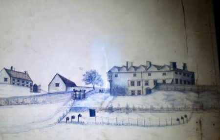
Paintings dating from after 1734 (Figures 2 and 3) show the hall probably little altered since the remodelling in the 17th century, i.e. a 14th century core with a gabled Elizabethan roof. However visible from the south are buildings in the position of the early 18th century stable block, which were probably put in place by Patience. The view from the south shows an area fringed by young trees, which may possibly be planting by Patience. He had purchased a copy of the ‘Compleat Gardener’ in 1703 (DA HP/24/1-3, possibly The Compleat Gardener by Jean De La Quintinie, translated by John Evelyn and first published in 1693) and was probably keen to make alterations to his new estate.
Patientius, son of Patience, inherited in 1734 and from an account book for 1735 to 1738, Mary, Patientius’ elder sister (WYASW SpSt/5/4/1/10) there are payments to workers for weeding, collecting wild flowers and also harvesting and hay making. It is possible by this time the walled garden to the south was in situ. By 1757, Patientius had built a hothouse because he records the purchase of 12 mats ‘for my hothouse’ that year (DA HP24/1-3). A survey taken in 1763 showed that Warde owned nearly 1,112 acres in Hooton Pagnell and rented another 10¼ acres from the neighbouring Ann(e) family of Frickley. Of these, 772 acres were 17 tenanted farms, 229 acres were in his own hand including the ‘Park’ and just under 111 acres were woods and waste grounds (Ruston and Witney 1934, 227).
1775 – 1822
The hall was transferred by Patientius to his son Saint Andrew shortly after Saint Andrew’s marriage to Mary Ann Cooke of Owston in 1775. Mary Ann was described as wealthy which made it possible for Saint Andrew to undertake a number of projects. The south front of the house was substantially modified in 1787 to a design of William Lindley (Harman and Pevsner 2017, 332) and gave a more fashionable facade with full height bow windows installed at either end with an outlook to the south. Interior modifications were made at the same time and a considerable number of outbuildings added, including an east service range, a coach house and dovecote and extensive garden walling of stone lined with brick.
From 1775 to 1794 there were also considerable rearrangements to the farmland and the immediate environs of the hall. Plans, drawn by Ruston and Witney from the terriers and contemporary maps, show the fields as they were before 1780 (Figure 4) and the rearrangements after 1794 (Figure 5). The 1780 boundaries for those areas where change is relevant to the garden and landscape are outlined in green. The revised arrangement in 1794 shows the park, Mapple Yard, to the west of the Hall and the field layout adjoining the house to the east with three well defined spaces (areas 4, 5 & 6). Prior to Warde ownership the Mapple Yard, like the Hooton Pagnell Common immediately to the north, was regarded as poor land and used as rough grazing (Ruston and Witney 1934, 93-4). Subdivision had been established in 1692 around the northern boundary and defined by hedging as indicated in Figure 4. The maintenance of hedging and fences with regard to grazing was recorded in 1719 (DA HP17/7-8). These boundaries had all been removed by 1794 and the Mapple area was enlarged from 11 to 68 acres (Ruston and Witney 1934, 109). This allowed for landscape to be updated with tree planting as clumps and shelter belts (Klemperer 2010, 394).
In addition to the layout shown on the Ruston and Witney 1794 plan there are smaller areas to the south of the hall, where today there is a large lawned area (2) adjoining and a walled garden (3) beyond (Figure 5). In the painting (Figure 2), there is no evidence of the two spaces so it is likely that they were created by Patientius or after. Areas 2 and 3, with the three areas to the east, provide five more or less rectangular plots in the immediate vicinity of the house. The Mapple Yard on the west is a much larger space providing an attractive view from the house. In 1805 there is another record (DA HP17/6-13) of the sale of wood where reference is made to wood from ornamental plantations. As the timber would need to be mature to be saleable this suggests ornamental plantations before the developments of 1794, work done in the times of Patience or Patientius.
1822 - 1878
On inheriting the property in 1822, Saint Andrew junior immediately advertised the property to rent (Yorkshire Gazette, 14 September). It was described as a desirable residence with ‘a spacious Family Mansion, with Offices, Stabling, Garden etc’. It was advertised again five years later, this time mentioning the pleasure grounds (Yorkshire Gazette, 2 June). By the tithe award of 1846, the occupant of the Hall was Arthur Saltmarshe, with Warde having about 118½ acres of woodland with a further 62 acres around the Hall (TNA IR29/43/216).
The tithe map of 1848 (Figure 6, TNA IR30/43/216) shows the Park (Mapple Yard) and areas adjoining the hall as on the Ruston and Witney 1794 plan (Figure 5) but with additional detail. Clumps of trees are indicated in the park and there are boundary plantations to the north, east and west and three ponds are shown. The lawn area adjoining the front of the hall (area 2) is shown as divided from the walled garden (area 3). There is a small building indicated in the centre of the dividing wall and another in top north east corner of the walled garden.
The Ordnance Survey 6” map of surveyed between 1849 and 1850 (Figure 7) shows in the park there was planting around the pair of ponds and an approximately east to west footpath. On the east-west boundary to the north of areas 4, 5 and 6, there is evidence of perhaps a garden and an avenue. The lawn (area 2) has paths and trees and what appears to be a garden plot to the north of the service area. The walled garden (area 3) also has a layout of paths and an entrance from the lawn, now blocked. In the north east corner, there are some additional small buildings. There is a slip garden outside the east wall of the walled garden. In the stable precinct (area 4) there is planting on the south boundary and in the south east corner. In area 5 there is a centrally located east to west avenue and planting on the north boundary.
1878 – 1931
In 1878, Sarah Julia Warde married William Aldam and in 1882 became sole owner of the estate after the death of her sister. This was the beginning of substantial programme of work including restoration of the hall and garden (Wood 1961, 62-3) after 1891. The Ordnance Survey 25” map surveyed in 1891 (Figure 8) shows no major developments but the small buildings in the walled garden are now identifiable. Along the wall between the lawn and the walled garden is a large glass house and probably a boiler house adjoining on the north side. The building in the top right corner is the gardener’s cottage. The adjoining small buildings are two smaller glasshouses and a basement boiler room. More extensive planting is shown in area 6 along with a perimeter path. In the early pages of the hall journals from 1893 (DA DD.WN A3/1) there is a long list of payments to garden suppliers, Suttons, Backhouse, Little and Balantyne, Hattersley Brothers and others for trees and items for a vegetable garden, suggesting an interest in the garden. In 1901 Julia donated land in the SE corner of the Mapple Yard for use as a graveyard and commissioned a lychgate in gothic style. This can be seen on the OS 1904 (Figure 9) and survives today. Also in OS 1904, for the first time, there is an additional area of woodland immediately to the north of areas 5, 6 & 8. This woodland also appears in OS 1928 (Figure 10) and remains today.
West of the hall, at the Elmsall Road entrance, an extravagant Arts and Crafts lodge incorporating a carriageway, pedestrian entrance and belvedere was built 1914 - 1920. A grand entrance from the lawn to the walled garden incorporates what seem to be 18th century gateposts, quite possibly relocated after building of the new entrance and belvedere. A handsome Arts and Crafts garden house (built between 1912 and 1923) replaced the wall in the south west corner of the lawn. The garden house is well laid out with small courtyard, steps and an elegant, detached, cloak room. Some, perhaps all, of these buildings were designed by Streatfield and Attwell (Harman and Pevsner 2017, 332). Probably, as part of the same programme, the estate office adjoining the area 2 south east corner of the lawn was restyled in an Arts and Crafts manner.
A large ornate glasshouse was built by Foster and Pearson in the walled garden just to the east of the new gateway. This first appears in OS map of 1928 (Figure 10), the earlier glasshouse still being indicated in OS map of 1904 (Figure 9). The two small glasshouses shown on OS map of 1891 (Figure 8) are said to have been lost by fire (Mark Warde Norbury, pers. comm.) and replaced by a small glasshouse by Foster and Pearson. This replacement appears in OS map of 1928 (Figure 10).
There are other minor garden buildings of this period. In area 3, there is a loggia in the centre of the southern wall and a workroom adjoining the boiler house for the small glasshouse. In area 2, there is an apparently a ruinous mystery building near the belvedere steps. All of these buildings seem to incorporate remains from much earlier buildings but are not of the quality of other early 20th century work. It is likely that they were built in Julia’s time by her ‘favourite stone mason’, George Henry Oates. In the southwest corner of the walled garden there is a substantial earth mound with stone steps affording a view back to the house, the Mapple yard and the surrounding landscape.
During the 1914 - 18 war the hall was run as a hospital with Julia acting both as ‘commandant’ and matron. She was awarded an MBE for her services. Julia continued garden work after the war and, at the hall, there is a garden journal for the period 1925 to 1929. This contains detailed records of suppliers, plants and planting instructions.
Later history
Sarah Julia Warde Aldam died in 1931 and the Hall and estate have subsequently passed to members of the Warde families up to the present day. The landscape and garden features described above have mostly survived although the large Foster and Pearson glasshouse is in a poor condition. The Mappleyard is a wheat field but the shelter belts survive. The walled areas, to the south of the hall survive as garden but with some loss of trees. The areas to the east of the Hall are not gardened. The area of woodland at the eastern extremity (area 6 of Figure 5) remains heavily wooded and may contain some of the original trees. It is not obvious whether any of the woodland pathway shown in OS map of 1891 (Figure 8) survives.
Location
Hooton Pagnell Hall is on the south side of the village of Hooton Pagnell, with land on both east and west sides of Elmsall lane (B6422) and approximately 6 miles north west of Doncaster.
Area
The historic designed landscape is approximately 84 acres (34 ha).
Boundaries
The Mapple Yard is bounded to the north by Clayton Lane and to the east by Elmsall Lane. The western boundary is the Mapple Yard Plantation, on the southern side is a field boundary beginning at the graveyard in the south east corner. On the east side of Elmsall Lane is the hall and its environs, the northern boundary is the wall separating the hall from the vicarage. The southern boundary is the estate wall beginning on the west adjoining Butt Lane then following an east-west field boundary where Butt Lane turns south. On the east extremity, at the edge of the woodland, there is a field boundary running north-south.
Landform
The hall and the area to the east are on fairly level ground at about 95m. The soil is fertile with a fairly high content of clay on the Cadeby Formation of Permian limestone. To the west, the Mapple Yard falls away to 55m on the west and 65m on the south. The soil is predominantly well drained clay with silt and sand on coal measures shale with an admixture of limestone on the north and east boundaries.
Setting
Hooton Pagnell Hall and the eastern plots lie in the Hooton Pagnell conservation area. Only the most northern part of the Mapple Yard is in the conservation area. The hall overlooks an arable landscape with long views to the south and west. On the north there is the ancient church of All Saints and beyond a characterful estate village with many listed buildings.
Entrances and approaches
Main Entrance (Grade II – NHLE 1151631)
The main entrance to the hall is through an Arts and Crafts combination of carriage way, pedestrian entrance and belvedere by Streatfield and Atwell (1914-20). A short carriageway leads to a Tudor archway and pedestrian entrance which is part of the original hall. Beyond the entrance is an open courtyard in the corner of the old hall and the late C18 service wing.
Principal buildings
Hooton Pagnell Hall (Grade II*- NHLE 1192355)
The hall origins are said to be 14th century, being built in the time of the third Sir Geoffrey Lutterell (Miller 1804, 281). The entrance archway and the room above survive from that time. At a later date the building was given Elizabethan gables. These were removed sometime in the 18th century after purchase by the Wardes. Further extensive modifications were made to the facade in the late 18th century to the designs of William Lindley. At this time a service wing was added on the east of the hall, also by Lindsey. In the late 19th and early 20th century, gothic aspects of the hall were restored and enhanced (Harman and Pevsner 2017, 332).
Stables (Grade II – NHLE 1314810)
Early 18th century stables probably built for Patience Warde with extensions in the late 18th century for Saint Andrew Warde by William Lindley (Harman and Pevsner 2017, 332). These make the east boundary to the hall lawn (area 2, Figure 5).
Estate office
Aspects of the interior suggest that this is an early building, perhaps of the time of the tithe barn. The exterior is in Arts and Crafts style, probably by Streatfield and Atwell for Mrs Warde Aldam. It merges with adjoining barn and stable buildings and overlooks the south east corner of the hall lawn.
Garden House (Grade II – NHLE 1286605)
Built 1914-23 by Streatfield and Atwell for Mrs Warde Aldam. Single large room in Arts and Crafts style and linked in to east-west garden wall.
Gardens and pleasure grounds
The setting of hall and landscape has changed little since the work of the late 18th century. There are considerable additions of late 19th and early 20th centuries, notably main entrance and belvedere, garden house, large glasshouse and garden entrance gateway. The Mapple Yard is now a wheat field and only the lawn space and walled garden at the hall remain as garden.
Kitchen garden
The further of the two spaces in front of the Hall, area 3 of Figure 5, might be a logical place to find a kitchen garden. It would have been hidden from the house by the original garden wall. In the early OS maps, there are paths from the stables to this area via a slip garden. The 1854 and 1891 OS maps show a large glasshouse in the centre of the north wall with a possible adjoining boiler room. This was demolished some time before 1930 to make way for a substantial entrance of pillars and gates. About the same time a large, ornate, glasshouse by Foster and Pearson was built immediately to the east of the new gateway. The 1891 OS shows two glasshouses and an underground boiler room in the north east quarter. Only one glasshouse, by Foster and Pearson, remains at this location the other being lost by fire. The underground boiler room has been filled in. Also in this area is the gardener’s cottage probably dating from the building programme of 1794 and after. However no records have been found to confirm the area as a kitchen garden and most of the 19th and 20th century building seems to be for the needs of a pleasure garden.
Park and plantations
The Park: Mapple Yard
A map drawn of the estate as it was in 1260 (Ruston and Witney 1934, 56) shows this area as ‘Demesne’. In 1692, some of the northern part is described as waste ground prior to enclosures for several owners for improvement (ibid, 93). In the north east corner was Mappleyard, then an 11 acre plot. The enclosures of the Demesne can be seen in the Ruston and Witney estate map of 1780. In 1794 the Mapple Yard was converted to a park when the enclosures, Mappleyard, Upper Pond Close, Lower Pond Close and other small ones were combined to give an open area of 68 acres. From then there was considerable tree planting (ibid, 109) of shelter belts and clumps in an ‘English Landscape’ style (Klemperer 2010, 394). In the tithe map of 1847, the area is named as Park and listed as grass [pasture]. OS maps from 1891 onwards describe the area as ‘Mapple Yard’. Today it is now arable. In the south east corner of the park area there survives an early C20 graveyard and lychgate, the gift of Mrs Warde Aldam.
Plantations
There are two named plantations on Mapple Yard, shown in outline from the Tithe map of 1847. They are named, as ‘First Plantation’ and ‘Mapple Yard Plantation’, on OS maps from 1891 onwards. The one other large area of woodland is area 6 of Figure 5. These areas are still woodland.
Water
There are several ponds on the Mapple yard. The Ruston and Witney map of the estate at 1260 (Figure 1) indicates two ponds in that area. Fishing was recorded in Mapple Yard ponds in the late 17th century (DA HP17/6-13) and pond cleaning recorded in 1718 (Ruston and Witney 1934, 106).
The two ponds are shown on the tithe map and on later OS maps shown with an enclosing copse. The OS maps also show a central pond with a copse and a spring in the north east corner. There is also a copse and possibly a pond in the north west quarter. All of these copses remain in-situ.
Books and articles
Harman, R. and Pevsner, N. 2017. The Buildings of England, Yorkshire West Riding: Sheffield and the South. London, Yale University Press.
Klemperer, M. 2010. Style and Social competition in the Large Scale Ornamental Landscape of the Doncaster District of South Yorkshire c.1680-1840. Oxford, Archaeopress.
Miller, E. 1804. The History and Antiquities of Doncaster and its Vicinity. Doncaster, W. Sheardown.
Ruston, A. and Witney, D. 1934. Hooton Pagnell, The Agricultural Evolution of a Yorkshire Village. London, Edward Arnold & Co.
Ryder, P.F. 1993. The Medieval Buildings of Yorkshire. England, Ash Grove Books.
Wood, G. B. 1961. North Country Profile. London, Country Life.
Primary sources
Doncaster Archives (DA)
DD WN A3/1-10 Journals from 1893
HP 24/1-3 Family and household accounts 1679-1820
HP 17/6-13 Fishing in pond on Mapple
HP 17/12-25 Sale of wood part from ornamental woodland and considerations of taxation
The National Archives (TNA)
IR 29/43/216 Tithe apportionment for Hooton Pagnell, 15 May 1846
IR 30/43/216 Tithe map for Hooton Pagnell, 1847
West Yorkshire Archive Services, Wakefield (WYASW)
SpSt/5/4/1/10 Account book for a garden (Mary Warde), 1735-8
SpSt/6/1/50 Letters to Miss Mary Warde
Maps
Ordnance Survey 1st edition 6”, surveyed 1849-50, published 1854
Ordnance Survey 1st edition 25”, surveyed 1891, published 1892
Ordnance Survey 2nd edition 25”, revised 1904, published 1907
Ordnance Survey edition of 1930, revised 1928, published 1930
Figure 1 – The Hooton Pagnell estate 1260. From: Hooton Pagnell, The Agricultural Evolution of a Yorkshire Village by Ruston and Witney, Figure 10, p56. © 1934 by Edward Arnold & Co.
Figure 2 - South prospect of Hooton Pagnell Hall, c. 1730. Private Collection.
Figure 3 - South West prospect of Hooton Pagnell Hall, c. 1730. Private Collection.
Figure 4 – The field layout c. 1780. From: Hooton Pagnell, The Agricultural Evolution of a Yorkshire Village by Ruston and Witney, Figure 18, p85. © 1934 by Edward Arnold & Co.
Figure 5 – The revised field layout 1794. From: Hooton Pagnell, The Agricultural Evolution of a Yorkshire Village by Ruston and Witney, Figure 19, p86. © 1934 by Edward Arnold & Co.
Figure 6 – Tithe map of 1847 showing the Park and gardens. © The National Archives.
Figure 7 – 1st edition 6” OS map, surveyed 1849-50 showing the Park and gardens. Reproduced by permission of the National Library of Scotland.
Figure 8 – 1st edition 25” OS map, surveyed 1891 giving detail of the gardens and planting. Reproduced by permission of the National Library of Scotland.
Figure 9 – Revised 25” OS map surveyed 1904 showing the Park and gardens. Reproduced by permission of the National Library of Scotland.
Figure 10 – Revised 6” OS map, surveyed 1928 showing the Park and gardens. Reproduced by permission of the National Library of Scotland.


. Areas of interest in outlined in green.")
. 1 Park/ Mapple Yard, 2 Lawn, 3 Walled garden, 4 Stable precinct, 5 Field with central avenue, 6 Woodland with walks")


