The designed landscape of Thorpe Hall, Rudston (gardens, parkland and plantations) is of particular historic interest because it retains much of the physical character that had been achieved by the early 20th century through three stages of development from the late 18th century. Of particular note are the two serpentine ponds or lakes, and the series of ornamental buildings in the grounds, especially the Dairy, all of the early 19th century. Also of interest is the late 19th century ornamental garden.
Estate owners
Thorpe, a township in Rudston parish, is first recorded in the Domesday Book in 1086 when an estate of 3 carucates was held by the count of Mortain. Following the confiscation of Mortain’s lands in 1106 the archbishop of Canterbury became overlord. Held by various demesne and under-tenants in the Middle Ages, including the Thorpe family in the 14th century, the manor was purchased by John Wood in 1557 since when it has not been sold. It remained in the Wood family until 1695 when Thomas Wood bequeathed the estate to his godson and great nephew Thomas Hassell (d. 1738) son of Samuel Hassell of Huttons Ambo, North Riding who married Ann Wentworth (d. 1748), daughter of Sir Matthew Wentworth of Bretton Hall, West Riding. Their son and heir Thomas Hassell (d. 1773) left Thorpe to Godfrey Bosville of Gunthwaite, near Penistone, husband of his niece Diana (née Wentworth). (Allison, VCH Yorks ER II, 314)
On the death of Godfrey Bosville in 1784 he was succeeded by his son William Bosville, on whose death in 1813 Thorpe passed to his nephew Godfrey Macdonald, who then changed his name to Bosville. On succeeding his brother to the peerage he became 3rd Lord Macdonald of Slate or Sleat in 1824. His eldest son, considered illegitimate, succeeded in 1832 to Thorpe, but not to the title and changed his surname to become Alexander W.R. Bosville (d. 1847). It was his grandson Alexander Wentworth Macdonald Bosville who, proving the legitimacy of his grandfather and regaining the baronetcy, changed his name to become Sir Alexander Bosville Macdonald in 1909. The property remains in the family.
The owners chiefly responsible for landscaping were:
Thomas Hassell, owner 1738-73
Godfrey Bosville, owner 1773-84
Godfrey Bosville, Lord Macdonald, owner 1813-32
Alexander W.M. Bosville, later Sir Alexander Bosville Macdonald, 14th Bt, owner 1865-1933, and his wife Alice, Lady Macdonald.
Early history of the site
Thorpe Hall is the only house on the site of the former village of Thorpe. Nothing is known of the village which was taxed with Rudston in 1377. The date of depopulation is unknown. The hall probably stands on the site of the medieval manor house of the Thorpe family. It was quite a modest house of four hearths in 1672 when owned by Thomas Wood.
The present house was probably built by Thomas Hassell (d. 1738) soon after his marriage in 1716 to Ann Wentworth (d. 1748), daughter of Sir Matthew Wentworth of Bretton Hall, West Riding. Various family connections were rebuilding their houses in the period 1710-20, including Sir Richard Osbaldeston at Hunmanby (uncle of Ann Wentworth and brother-in-law of her husband Thomas Hassell) and Sir William Wentworth at Bretton Hall (brother of Ann Wentworth). Ann linked Thomas Hassell and Thorpe with the early patrons of William Kent. These were her brother Sir William Wentworth, her uncle Sir William Hustler, and her cousin Richard Osbaldeston, Dean of York. (Neave, ‘The Early Life of William Kent’, 5-7)
As regards Thorpe township there are references to land in the North and South Fields in 1688 and 1775 and at the latter date the ‘arable part of Thorpe North Field’ is mentioned. (Allison, VCH Yorks ER II, 316)
Chronological history of the designed landscape
Mid-18th century
Although Thomas Hassell rebuilt the house in the early 18th century neither he nor his son appear to have carried out any significant landscaping. The only clue to the setting of the house in the mid-late 18th century comes from the two editions of Thomas Jefferys’ county maps of 1772 and 1775, a reasonably reliable guide to the general appearance of parkland around country houses at this time. No parkland is shown around Thorpe Hall, the only planting being a square block of trees on the Wolds some distance to the south-west of the house.
Late 18th century
The next available county plan is that by Henry Teesdale, published 1828. It was surveyed in 1817, and corrected 1827-8. The plan shows the setting of Thorpe in 1817, and most likely reflects planting carried out before 1784, after which the estate was virtually abandoned by its owner for thirty years (see below).
By the early 19th century there was considerable mature woodland around the house and on the Wolds hillside to the south. This is likely to be the result of planting by Godfrey and Diana Bosville. They moved from Gunthwaite in the West Riding to Thorpe soon after taking possession of the estate in 1773. Diana’s brother, Sir Thomas Wentworth was landscaping the grounds at Bretton Hall in the 1760s-70s and it would be surprising if she and her husband did not undertake some planting, and laying out of the grounds at Thorpe during their short tenure of the estate.
Plans were made to extend the house and in 1778-9 Diana Bosville was corresponding with the Doncaster architect William Lindley about his design of the wings that were added to Thorpe Hall at that time. A suggestion of an intention to lay out the grounds comes from a letter from Lindley to Mrs Bosville written in October 1779 which refers to ‘the several little ornamental Buildings you may have occation (sic) to Erect about the House or in the Grounds &c’ (HHC, U DDBM/32/7) A ‘magnificent Roothouse’ had already been erected where Mrs Anna Maria Greame of Sewerby Hall dined in July 1779. She also ‘walked in a Grove which was illuminated in the manner of Vauxhall’. (Macdonald, Fortunes of a Family, 122) The location and nature of the roothouse is unknown but it was clearly large enough for a group of guests to dine in and probably close to the house. The suggestion by Francis Johnson that the roothouse was replaced by the gallery (the east wing of the hall) cannot be correct, but it could have been on the site of the orangery and billiard room. (Johnson, ‘Thorpe Hall’, 44-5) The ‘Grove’ may have been the wooded area to the north, between the house and the road.
The setting of Thorpe Hall was briefly described by Dorothy Richardson in 1802:
the House stands at a little distance from the road to the right in a very low situation … a lawn with a gravel road thro’ it descends from the public road to the house which has a very pretty piece of tufted ground behind it & towards the east – the public road is bounded by a belt of wood in which are two opens, shewing this pleasing retired seat to advantage. (JRL, English MS 1126)
The walled kitchen garden, along with the stables, was probably built about 1780. Dorothy Richardson noted a brick garden wall to the west of the grounds in 1802. (JRL, English MS 1126)
On the death of Godfrey Bosville in 1784 the estate passed to his son William Bosville (1745-1813), a celebrated radical, who through the rest of his life carefully avoided Thorpe ‘lest he should be involuntarily dragged into the duties and troubles of a landowner’. (Stirling, A Painter of Dreams, 111; DNB)
1813-1832
It is very likely that no alterations were made to the hall or grounds in the thirty years before 1813 when the estate was inherited by Godfrey Macdonald, who changed his name to Bosville on succeeding his uncle. He resumed the surname Macdonald on succeeding his brother as Lord Macdonald in 1824.
Upper and Lower Pond: Godfrey Bosville almost immediately commenced landscaping the grounds. They harnessed the Gypsey Race as it ran through the grounds to the south of the house and created ‘by a most crafty system of canals weirs etc. and ponds at different levels …. an extremely clever water garden.’ (Johnson, ‘Account of visits to country houses’) The Upper Pond, directly south of the house, was said to have been dug in 1815, to give ‘employment to some men during the trade depression following Waterloo’, and the Lower Pond a few years later. (Macdonald, Romantic Chapter, 24; Wood, Historic Homes, 126.) The actual date of digging the ponds, described as ‘a brilliant feat of engineering’ is unclear although possibly not completed until after 1817, as they do not appear on Teesdale’s plan surveyed 1817-18, but they do on Byrant’s plan surveyed 1827-8 (above). (Wood, Historic Homes, 126.) The ponds were enlarged in 1830. (Sheahan and Whellan, York and the East Riding, II, 489.)
Plantations: Bosville was evidently responsible for the area of parkland called South Side, dotted with groups of trees and surrounded by narrow plantations, running up the hillside to the chalk ridge carrying Woldgate, as shown on Bryant’s plan (above p. 4) To the east the Great Pasture was in part park-like with groups of trees dotted around. To the south of the Lower Pond the broader Carr Plantation was planted stretching east to the boundary with Caythorpe township.
Gardens: Near the house Mrs Bosville planted roses and lilac bushes, and a lime avenue was planted down the drive. (Macdonald, Romantic Chapter, 24; ibid., House of the Isles, 122.)
Garden buildings: At this time the grounds were enhanced by a number of charming ornamental buildings including the delightful dairy, the orangery and billiard room, an octagonal game larder and hexagonal wooden dovecot. All but the last survive and are illustrated and described below. The ice house (see below), with its entrance off the main road, may be of this period or of c. 1780.
The first edition Ordnance Survey plan published 1854 almost certainly shows the gardens and parkland as left on the death of Lord Macdonald in 1832.
A drawing of c. 1830 of the view of Thorpe Hall from the Lower Pond shows the grounds as laid out by Lord Macdonald. A thick belt of woodland lies to the north of the house and orangery. The area to the south of the appears to have been open grassland with a few bushes or young trees; there is no sign of flower gardens. The grassed area or lawn is divided from the pond by a fence, probably cast-iron (see entrance gates below), and the pond is flanked by ornamental trees.
A painting dating from a few years later, possibly of the mid-late 1840s shows a similar scene but the fence has been removed and there are substantial trees in the parkland to the east. On the west an avenue of trees leads down to the west end of the Lower Pond.
Nothing is known of any changes to the grounds in the mid-19th century. The family were often non-resident, following the death of Alexander Bosville in 1847 and the house was leased to tenants at the time of the census in 1851 and 1861. (Census Enumerators’ Returns) The gardens were however maintained by the gardener Alexander Mills or Milnes, a Scot, who worked on the estate from 1829 until his death in 1861 (Hull Packet 13 Dec. 1861) Mills was succeeded by his assistant Robert Berriman, who in turn was followed by his son William Berriman by 1891. (Census Enumerators’ Returns)
Late 19th-early 20th century
It was the coming of age in 1886 of Alexander W.M. Bosville, who had inherited the estate as a baby, and his marriage that year to Alice Middleton that brought about changes to the house and grounds. Immediately extensive additions were made on the west side of the house, and soon after Alice, later Lady Macdonald, set about transforming the gardens. In her memoirs All the Days of My Life published in 1929 Lady Macdonald recalled that when she first came to Thorpe Hall it stood ‘close to a grass field at the back of the house [south side], and not far from the road which passed in front of it [north side]; this looked very wrong to my Scottish eyes, accustomed as they were to “policies” [that is, shrubberies and gardens all round a family house], so presently, Alex let me make a garden behind the house, stretching down to the “Ponds” – enlargements of the Gipsy Beck which ran past at the foot of the opposite hill. This garden became very pretty as the years went on, and has now made for itself quite a reputation for beauty. Near the house, terraces and steps were made, and a stone terrace with balustrading and curved steps was attached to the old part of the house. Here stand big bay-trees and flowering shrubs in pots, and among them comfortable white painted wicker garden chairs, and at the back a big oak settle. A broad grass walk hedged with yew leads from the terraces right down the garden, and the look of this is continued on the opposite shore of the ponds up the hill to a vista through the wood on its top. This grass walk is intersected by a lavender walk and a small yew walk leading to little hidden gardens – and a little ‘Secret Garden’ lies behind pleached limes to the west of the grass central walk. A fine lead Mercury, designed by J. H. M. Furse, stands at the end of the broad grass walk farthest from the house. Other “old stone” statues are placed in nooks about the garden.’ (Macdonald, All the Days, 50-51)
The Secret Garden, bounded by lime hedges, and to the west of the main lawn, was the last addition to the gardens, possibly in the early 1920s (Wood, Historic Homes, 126-7) Lady Macdonald also noted that ‘the east side of the gardens beyond the rough grass bit for bulbs and beyond a gravel walk and the shelter border’ was the village cricket ground ‘just below the terraced croquet ground’. Backing the croquet ground was the orangery and reception room which served as the cricket pavilion. (Macdonald, All the Days of My Life, 51)
Other changes to the wider landscape in the later 19th century concerned the plantations. The plantation along Woldgate and bounding the southern edge of South Side and forming an end to the landscape to the south was cleared away before 1890, as was the southern half of the plantation bordering the east side of South Side. The most southerly section of the narrow plantation bordering the west side of South Side was removed between 1890 and 1910.
A new plantation known as The Belt, eventually extending to 19 acres (ha) was created in the south-west corner of the parkland south of the Upper Pond, between 1890 and 1910, by extending westwards the northern part of the South Side plantation on the western edge of the Great Pasture to incorporate four large clumps of trees shown on the 1850s Ordnance Survey map.
Mid-late 20th Century
No major changes were made to the layout of the gardens and parkland in the 20th century. The death of Alice, Lady Macdonald in 1935 and the Second World War had an impact on the grounds. The architect Francis Johnson visited Thorpe Hall in 1948 and noted how the ponds had become dry:
During the War a fool of a ministry official dredged the clay bed of the beck away further west and now for most of the year the garden is dry. All the fish have gone…and for this damage to his amenities Sir Godfrey has managed to obtain compensation. (Johnson, ‘Account of visits to country houses’)
Location
Thorpe Hall and its parkland lie in the valley of the Gypsey Race east of the village of Rudston about 4 miles (6.5 km) west of Bridlington, to the south of the B 1253
Area
The gardens, the parkland to the east of the house and the fishponds cover some 80 acres (32.4 ha). The parkland and plantations immediately to the south of the fishponds (including the Carr Plantation) cover a further 78 acres (31.5 ha) or thereabouts.
In the mid-19th century the designed landscape extended to Woldgate to the south including four fields, now arable, that covered some 110 acres (44.5 ha) bounded by perimeter plantations. The Great Pasture, 138 acres (56 ha) was also parklike in character at that time.
Boundaries
The grounds are bounded on the north by the B1253 road from Rudston to Bridlington and on the east by the boundary with Caythorpe township. The walled garden, now a touring caravan site, forms the north-western boundary. Much of the southern boundary of the designed landscape today is formed by Carr Plantation and a large triangular plantation called The Belt. In the 19th and early 20th century the southern boundary was Woldgate.
Landform
Thorpe Hall is in the valley of the Gypsey Race and the area of gardens, parkland and plantations lies between 20m and 82 m AOD rising quite steeply north to south. Geologically the bedrock is chalk (Flamborough Chalk Formation). Most of the lower grounds, including the area of the two ponds are covered by a superficial deposit of alluvium. On the higher ground to the south the superficial deposit is boulder clay (Devensian Till).
Setting
The gardens, parkland and woodland of Thorpe Hall lie in the valley of the chalk stream, the Gypsey Race, with higher Wold land to the north and south. It is in East Riding Landscape Character Type 15 Wolds Valley Farmland. There are arable fields to the north and south of the grounds, with a typical Wolds field pattern.
Entrances and approaches
The grounds are entered from the B1253 Bridlington to Rudston road. The entrance from the west is though a pair of early 19th century cast-iron gates (probably by William Crosskill of Beverley) directly into the grounds to the north-west of Thorpe Hall. From the east a similar pair of gates adjoins a late 19th century lodge (probably of the 1870s), leading to a drive some 700 metres long running on the north side of the open parkland.
Principal Buildings
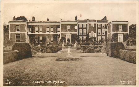
Thorpe Hall Listed Grade II*
A large house built at four main periods. The original three-storey five-bay block probably dates from soon after 1716. Single-storey wings were added to the left and right in 1778-80 to the designs of William Lindley, with a second storey added c. 1815-20. At this time much of the interior was altered. In 1886 a large service block designed by W.S. Weatherley was added to the west.
The Dairy Listed Grade I
Situated in the grounds to the west of Thorpe Hall. A delightful model dairy in a rustic picturesque style built in 1821; an elongated octagon surrounded by a verandah. The interior, which is entirely covered with coloured glazed tiles, has a perimeter shelf and central table. The windows have stained glass with female figures representing the four seasons. (For reference to ‘the much admired and truly beautiful dairy’ see Hull Rockingham, 4 Dec 1830.)
Orangery and Billiard Room Listed Grade II
North-east of the house an early 19th-century billiard room, of three bays, with five-bay orangery attached on the right. Said to be of 1821, the unmatched pair are in a simple neo-classical style, with round-arched openings and Greek-key frieze.
Game Larder Listed Grade II
Some 50 yards south of the dairy is an unusual octagonal game larder of louvered timber -work in a picturesque style with Gothick openings and cupola. Architecturally associated with the dairy and of the same date, 1821.
Icehouse Listed Grade II
The icehouse is situated to the north of the house with the entrance off the Bridlington road. A domed brick structure covered with soil. Round-arched entrance with boarded door leading to tunnel. Probably early 19th century.
Stable Block Listed Grade II
South-west of Thorpe Hall is a brick stable block of thirteen bays with centre projecting slightly under low pediment. Probably of c. 1780, possibly designed by William Lindley.
Stable Bridge Listed Grade II
About 60 metres south-east of the stables over the Gypsey Race at west end of Upper Pond. Early 19th-century three-arched brick bridge with stone dressings faced with sea-worn stone from Filey Brig.
Bridge over Gypsey Race Listed Grade II
About 500 metres south-west of Thorpe Hall. Late 18th-century brick bridge with stone dressings. Single elliptical arch.
Gardens and pleasure grounds
The layout of the late 19th century formal gardens to the south of the house still remained in 2013 but lacked flower beds and ornamental bushes. The broad walk leads down to the Upper Pond.
Kitchen Garden
The late 18th-century brick walls of the kitchen garden to the west of the house remained in 2013, but the gardens themselves were cleared for the present caravan park some 30 years ago.
Park and plantations
There are two areas of parkland at Thorpe Hall. The larger area covering about 34 acres (13.75 ha) lies east of the house, and north of the ponds and the Carr Plantation. This area contains ridge and furrow running north-south, a remnant of one of the open arable fields. (Further east but not part of the grounds is an area of parkland in Caythorpe township.) The second area of surviving parkland lies to the south of the Upper Pond.
Plantations
The Carr Plantation to the south and east of the Lower Pond retains the shape it had in the mid-19th century and covers 19.5 acres (7.9 ha). The Belt plantation of 19 acres (7.7 ha), created in the late 19th century, remains with two avenues cut through north-south linked by a diagonal avenue. Also much as in late 19th century are Zigzag plantation on the north-western edge of South Side and part of the adjoining narrow South Side Plantation to the south, and the narrow plantation on the northern edge of South Side, known as Daniel Dale Plantation in 1854 and Hop Walk by 1890 and later.
Water
The Lower and Upper Ponds, although overgrown in part, retain their early 19th-century shape and extend for nearly half a mile, west to east. In 1957 it was noted that ‘a walk beside these serpentine lakes is a sheer delight. It begins near the Stable Bridge, which spans the stream above the Upper Pond….. Thick beds of rushes, several islands, miniature waterfalls – these and much else gladden the mind as the lakeside paths are followed. All around are beautiful trees, and at one’s feet uncommon little flowers. (Wood, Historic Homes, 126)
Books and articles
K.J. Allison (ed), Victoria County History, Yorkshire, East Riding, II, 1974
F. Johnson, ‘Thorpe Hall, Rudston’ Proceedings of Royal Archaeological Society (1984), 44-5
Alice, Lady Macdonald, A Romantic Chapter in Family History, 1911
Alice, Lady Macdonald, The House of the Isles, 1925
Alice, Lady Macdonald, The Fortunes of a Family, 1928
Alice, Lady Macdonald, All the Days of My Life, 1929
D. Neave & D.Turnbull, Landscaped Parks and Gardens of East Yorkshire, 1992
S. & D. Neave, ‘The Early Life of William Kent’, The Georgian Group Journal VI (1996), 5-7
J.J. Sheahan & T. Whellan, History and Topography of York and the East Riding of Yorkshire II, 1856
A.M.W. Stirling, A Painter of Dreams, 1916
G. B. Wood, Historic Homes of Yorkshire, 1957, 123-127 - Chapter 24 Thorpe Hall, Rudston.
Primary sources
Hull History Centre (HHC), U DDBM Papers of the Bosville-Macdonald Family of Gunthwaite, Thorpe and Skye
John Rylands Library (JRL), University of Manchester, English MS 1126, Journal of Dorothy Richardson, 1802
Private Collection, Francis Johnson Mss ‘Account of visits to country houses’
Newspapers
Hull Packet
Maps
Thorpe House and Pleasure Grounds Surveyed by Robert Wise 1860 – Reproduced on cover and p. 9 of Michael S. Kemp, Bookseller Catalogue 56 (Spring 2008)
T. Jefferys, Yorkshire, published 1772 & 1775
H. Teesdale, Yorkshire, surveyed 1817-18, published 1828
A . Bryant , East Riding surveyed 1827-8, published 1829
Ordnance Survey maps published 1854 - 2012


, published 1910. National Library of Scotland CC-BY-NC-SA")