Woodhall has been the site of a manor house then Hall for at least 500 years, with its strategic location next to the River Derwent being its key attraction. One of the earliest surviving parts of the designed landscape is the terrace built along the riverbank, possibly created in the latter part of the 18th century. The current Wood Hall dates from the early 19th century and was built for John Reeves. The Menzies family, on buying the estate in 1835, shaped the historic landscape we see today, including the parkland both north and south of the Hall, the pleasure grounds, the remodelling of the kitchen garden and the creation of the ‘Fishpond’.
Estate owners
In the 17th century a large holding at Woodhall was built up by the Kirlew family and sold c. 1674 by Thomas Kirlew to Joshua Colston. In 1700, Colston's three daughters, sold the manor of Woodhall to William Mason (Burton 1888, 204) and in 1717, Mason's daughter, Frances Barker, and her husband sold it to Mary Henson the elder. After her death, Mary’s trustees sold the estate in 1743 to John Burton, husband of her daughter Mary. John Graham (d 1773) bought it from the Burtons four years later. His only daughter, Maria (c. 1735 - 1801), left it in her will to John, the son of her servant Charles Reeves. However he died ten years later and passed Wood Hall to his brother, Charles.
In 1835, Charles sold the estate of 239 acres to Robert Menzies (c. 1780 – 1859) for £9,000 (Burton 1888, 208). Robert’s son, Robert William (1822 – 1887) inherited on his death. Robert William’s widow, Julia and his only daughter Henrietta, continued to live at Woodhall after his death but the property went to his son, Stuart Alexander (c. 1850 – 1895). Stuart’s widow, Charlotte Menzies, put it up for sale in 1913 and eventually sold it in 1921 to Richard Bramley, the tenant of Hall Farm (VCH 1976, 52-55 & HHC C DBHT/9/834). The Bramley family still own the estate.
Key owners responsible for the development of the designed landscape and the dates of their involvement:
John Graham (1747 – 1773)
John Reeves (1801 – 1811)
Robert Menzies (1835 – 1859)
Robert William Menzies (1859 – 1887)
Early history of the site
The earliest mention of Woodhall is in 1133-40 when the Bishop of Durham gave three bovates of land there to the Priory of Durham. It was then called ‘Grimesthorpe’ but by c. 1190, it was known as ‘Wudehalle’ when the woods there and in neighbouring Brackenholme were subject to a dispute between the Bishop and the Priory (Farrer 1915, 322-3). The lands (and six messuages) continued to be held by the Bishop throughout the medieval period according to official records.
In the 16th century, Woodhall was split between a number of owners and the house, possibly the one later called ‘Old Hall’ on the 1st edition OS map (Figure 1), was mentioned in 1570 (VCH 1976, 52-55). After the tenure of the Kirlew family, it passed through a series of owners who possibly lived elsewhere until John Graham acquired Woodhall in 1747. Both he and his daughter were buried at Hemingbrough, so it is likely that they were residents of the ‘Old Hall’. Jeffrey’s map of c. 1771 (Figure 2) depicts a house at Wood Hall but with no obvious parkland. On the later estate map (ERA DDTR 802, Figure 3), an orchard was shown due west and two enclosed garden areas to the south of the old hall. Along the river was a terrace bank dotted with trees (Figure 4) that may date from the second half of the eighteenth century, as Burton (1888, 209) noted ‘to the taste of Mr Graham is due a fine terraced walk which runs along the bank of the Derwent’.
Chronological history of the designed landscape
John Reeves, on inheriting the estate from his father’s employer in 1801, built the current Hall the following year (Burton 1888, 208; Sheahan and Whellan 1857, 623). The estate plan of 1835 (ERA DDTR 802, Figure 3) showed the new house with the main entrance facing east towards the river Derwent. In front of it was an area of open ground with a thin line of trees (and possibly the current ha-ha) dividing it and an area of parkland called ‘Hall Pasture’ of just over 19 acres (Figure 4). There were small plantations to the north and south of the open area and at the south west corner of the kitchen garden. To the north of the hall was an orchard of just over an acre. The walled kitchen garden of about 1.5 acres was next to the southern wing of the house and had possibly a greenhouse on the outside of its western wall, perhaps in a slip garden (a strip of land outside the walls to grow additional crops). It also had the unusual feature of narrow canals of water running alongside the western and southern walls. They may have been created to improve drainage in the kitchen garden.
On either side of the road north (later ‘Woodhall Lane’) was an area of common land with areas of water, again possibly to aid drainage. The settlements here were the remains of the hamlet of Woodhall. At this stage, the public road forked at the top of ‘Common End Close’ with the main route continuing due east past the entrance to new Woodhall and then turning north again alongside the orchard of the old manor house.
The house was enlarged by Robert Menzies around 1838 (Sheahan and Whellan 1857, 623) with a square two-storeyed addition in white brick on the eastern side and a large Venetian staircase window. He may also have added the glasshouses on the northern wall of the kitchen garden, depicted on later OS maps (Figure 5). He also began to reshape the designed landscape. By 1843, he had removed the public road north (Woodhall Lane), so that it ran straight past his properties (NA IR 30/41/28), possibly when the Hull to Selby railway was completed in 1840. The 1st edition OS 6” map, surveyed between 1849 and 1851 (Figure 1), showed the new road with a belt of trees lining it on the eastern side from the railway crossing to the new estate entrance. A small lake (‘Fishpond’) of 0.7 acres had been created just to the east of this.
The fields to the north (3 ‘Sand Closes’ c. 15 acres and ‘Croft’ of c. 2.5 acres), together with the small orchard and ‘Stock Garth’ had been converted into parkland and buildings there had been removed by 1851. All of the fields north of the new railway line to the river bank on the east had also been made into parkland and the area was now called ‘Woodhall Park’. Further service buildings had been added to the north of the Hall that would later form ‘Woodhall Farm’. The area to the north of Wood Hall that was previously an orchard had been divided up and was possibly further pleasure grounds to complement those to the east of the house. The walled orchard attached to the old manor house remained but the former gardens to the south appear to have been remodelled. Whilst it is not entirely clear from the map, it seems that the water canals around the walled kitchen garden had been removed and the exterior walls to the west and south moved.
In 1854, Menzies was perhaps clearing more areas of the parkland given the following advertisement: ‘Superior Oak and Ash Timber, suitable for shipbuilding and railway purposes…the following large-sized Trees now standing upon Woodhall Farm near Hemingbrough…126 Numbered Oak Trees, 38 Numbered Ash Trees’ (Yorkshire Gazette, 4 November). A description from 1857, noted: ‘Robert Menzies Esq…resides at Wood Hall in this township a large white brick mansion erected in 1802 and enlarged some eighteen years ago by Mr Menzies after he had purchased the estate from the Reeves family. The house is pleasantly situated and surrounded by fine wood and plantations (Sheahan and Whellan, 623).
No specific designer has been attributed to the layout of the designed landscape but it may have been done by the head gardener, George Sellers (c. 1814 – 1894). He was the son of Robert, a gardener based at East Brick Yard in Norton, near Malton at the time of his son’s birth. Sellers arrived at Woodhall before March 1841 (census information) and remained there until c. 1883, when he retired. In 1863, he won a second prize for his melons at the Howdenshire Floral and Horticultural Society (Yorkshire Gazette, 15 August).
Burton (209) gives us a description of the estate in 1888: ‘the house stands, as of old, with a dark wood behind it, facing the south, and on the bank of the Derwent. The white walls contrast well with the tall forest trees to the rear. On the opposite bank of the river are the remains of Wressle, the ruined castle of the Percies, and in front is Hagthorpe, with its manor-house and moat. The gardens at Woodhall are laid out in the Dutch style’. It is not clear precisely what he meant by this but it may have involved topiary and formal garden areas such as parterres. A photograph (Private Collection) taken in the 1870s shows a terrace around the east and south of the house, surrounded by a low hedge and some steps, flanked by urns on pedestals, leading to a lawned area with formal island beds. The 1st edition 25” OS map surveyed in 1889 (Figure 5) shows this area, together with an avenue of conifers leading due east towards the ha-ha. These were (possibly) six Cedar of Lebanon [Cedrus libani] with two Monterey Pines [Pinus radiata] next to the park (current owner, pers. com.).
The most significant changes by 1889, were the addition of the avenue of trees, including limes, along the carriageway from the entrance off Woodhall Lane to the north front of the house and the removal of the walls around the old orchard. By 1905, the kitchen garden’s interior appears to have been cleared, including the building in the middle (Figure 6).
In the sale catalogue of 1913 (HHC C DBHT/9/834), the estate and grounds were described as:
‘The Charming and Substantially Built Mansion known as “Wood Hall”, commanding delightful views, standing in beautiful grounds and a well-timbered Park, approached by a magnificent Avenue of Forest Trees leading out of the Highway from South Duffield to Brackenholme…
The outbuildings include:- Vineries, Potting Sheds &c…There are extensive Lawns and Pleasure Grounds and a productive Walled-in Kitchen Garden, the whole covering an area of about 8 acres.
The photograph of the Hall in the sale catalogue shows a large deciduous tree due south of the Hall. This may be the tulip tree [Liriodendron tulipifera] that was noted for its size (current owner, pers. com.).
By 1938, part of the avenue of trees had been removed, together with most of the trees in the northern parkland. The southern wall of the kitchen garden was now missing and also part of the conservatory on the southern wall of the Hall (Figure 7). Parts of the eastern and western walls of the kitchen garden were later removed.
Location
The Wood Hall estate is 2.5 km (1.5 miles) north east of Hemingbrough and 8 km (5 miles) east of Selby.
Area
The historic estate covered 46 hectares (115 acres).
Boundaries
The southern boundary is formed by the railway line from Hull to Selby and the western boundary by Woodhall Lane from the railway to SE 694 323. The northern boundary and the northern section of the eastern boundary is formed by the shelterbelt of trees to SE 697 320. The northern boundary then runs from SE 697 319 to the River Derwent, the latter forming the rest of the eastern boundary.
Landform
The underlying bedrock geology is the Sherwood Sandstone Group. In the western section of the estate, there are superficial deposits of sand, giving rise to naturally wet, very acid sandy and loamy soils with low fertility. There are alluvial deposits of clay, silt, sand and gravel in the eastern section next to river. The soil here is loamy and clayey with naturally high groundwater due to the floodplain and moderate fertility.
Setting
Wood Hall lies in the National Characterisation Area of the Humberhead Levels, an area of low lying farmland and the Selby DC Characterisation Area of East Selby Farmland. The Hall and western section of parkland is on flat land at 5m AOD, the land sloping gently down to the River Derwent at 3m AOD.
Entrances and approaches
The historic main entrance was off Woodhall Lane and followed the original public road that was diverted between 1838 and 1843. The carriageway, lined with trees, then continued east until it turned sharply south west to the Hall (Figure 5).
Principal buildings
Wood Hall [Grade II, NHLE 1296593]
Built in 1802 for John Reeves with additions c. 1838 for Robert Menzies.
Former manor house of Wood Hall
Shown on Jeffrey’s map of 1771, it was located to the north east of the current Hall. It was still marked on the 1938 OS map but little remains now above ground.
Gardens and pleasure grounds
The first manor house had two walled gardens to the south of the main building (Figure 3) with a small building (summerhouse?) in the southwest corner of the western section. It is not clear from the plan whether they were productive or ornamental. To the east of these was an area that was planted with trees, possibly a pleasure ground. To the west was a large orchard of c. 1¼ acres and to the south of it an avenue of trees that may have been associated with a former entrance. Along the riverbank was a raised terrace that had trees either side in the late 18th century but were gradually removed in the 19th century.
By 1835, there had been some planting to the north and south of the open area to the east of the new hall and there was another orchard to the north (Figure 3). With the removal of the public road to the north, by 1849 there were pleasure grounds surrounding the hall between it and the old road (Figure 1). Immediately to the south and east of the Hall was a raised terraced garden described in Section 3.3.
Kitchen garden
The first kitchen garden may be one of the walled enclosures south of the old hall described above. By 1835, a new large walled kitchen garden had been created south of the new hall and covered just under 1½ acres. Around the outside by the western and southern walls were canals (Figure 3). After 1835 it was remodelled, with the areas of water filled in and the eastern wall and western walls moved west, possibly at the same time that the house was altered. The building inside the area was probably a greenhouse and this remained in place until 1905. On the northern wall was a series of glasshouses (‘vineries’) constructed before 1850 that were gradually reduced after the sale in 1921, with only the eastern section remaining by 1938 (Figure 7). Behind the glasshouses was a range of buildings that included a boiler house (current owner, pers. com.) and potting sheds (HHC C DBHT/9/834).
Park and plantations
There were two areas of grassland ‘Hall Pasture’ (19 acres) and ‘Seavy Pasture’ (12½ acres) to the east and south respectively of the new Hall in 1835 that later formed the park. The rest of the area marked as parkland on the 1st edition OS map (Figure 1) were fields at that time, so the area to the north of the carriageway (previously Middle Sand Close and Sand Close) was converted to parkland between 1835 and 1849. Apart from the remnants of the old field boundaries, the only woodland was the narrow plantation belt along the public road (Woodhall Lane) from the railway crossing to the main entrance. By 1889, there were two avenues of trees that bordered the main carriageway.
Water
The ‘Fish Pond’ next to Woodhall Lane and covering c. ¾ acre was created between 1835 and 1849. A smaller area of water is shown in the 1835 plan and this may have been an extension of this. Near the riverbank was the ‘Line Pond’ (about a fifth of an acre) that was created before 1835 and may be part of the late 18th century landscaping as it is next to the raised terrace. It is shown on the first map of 1835 (Figure 4) as conjoined ponds and then on later maps as a single area of water. Its purpose is unknown but it may have been used to store fish, as a 1602 plan of Wressle (on the opposite side of the river) shows fish weirs in the river here (Ed Dennison, pers. com.). There is currently a large area of water running parallel with the river, created after 1950, north of this.
Books and articles
Burton, T. 1888. The History and Antiquities of the Parish of Hemingbrough in the County of York. York, Samson Brothers.
Farrer, W. 1915. Early Yorkshire Charters Volume II. Edinburgh, Ballantyne, Hanson & Co.
Sheahan, J. J. and Whellan, T. 1857. History and Topography of the City of York, the Ainsty Wapentake, and the East Riding of Yorkshire, Vol. ii. Beverley, John Green.
VCH 1976. A History of the County of York East Riding: Volume 3, Ouse and Derwent Wapentake, and Part of Harthill Wapentake. London, Victoria County History.
Primary sources
East Riding Archives (ERA)
DDTR 802 Plan of the Manor and Estate of Wood Hall in the parish of Hemingborough, the property of Robert Menzies Esq, December 1835
Hull History Centre (HHC)
C DBHT/9/834 Sale catalogue of the Wood Hall estate, Brackenholme, 1913
National Archives (NA)
IR 30/41/28 Tithe map for township of Brackenholme cum Woodhall, 1843
Newspapers
The Yorkshire Post and Leeds Mercury
Yorkshire Gazette
Maps
Jeffrey’s map of Yorkshire, Plate 13
Ordnance Survey 6” 1st edition, surveyed 1849 to 1851, published 1854
Ordnance Survey 25” 1st edition, surveyed 1889, published 1891
Ordnance Survey 25” 2nd edition, revised 1905, published 1907
Ordnance Survey 25” Rev edition, revised 1938, published 1940
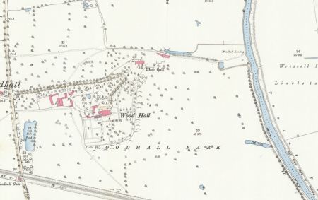
Figure 1 – Wood Hall estate from the 1st edition OS map surveyed 1849 to 1851, published 1854, showing the ‘Old Hall’, new parkland and pleasure grounds. Reproduced by permission of the National Library of Scotland.
Figure 2 – Old manor house of Woodhall on Jeffrey’s map of Yorkshire c. 1771, Plate 13. Source: North Yorkshire County Record Office.
Figure 3 - Detail of estate plan (DDTR 802, 1835) showing new Hall and kitchen garden, old manor house and orchards. Source: East Riding Archives
Figure 4 - Detail of estate plan (DDTR 802, 1835) showing terrace along riverbank, ‘Line Pond’ and ‘Hall Pasture’. Source: East Riding Archives
Figure 5 – Wood Hall estate from Ordnance Survey 25” 1st edition, surveyed 1889, published 1891, showing new tree avenue along drive and terraced garden around the Hall. Reproduced by permission of the National Library of Scotland.
Figure 6 - Wood Hall estate from Ordnance Survey 25” 2nd edition, revised 1905, published 1907, showing the clearance of the kitchen garden. Reproduced by permission of the National Library of Scotland.
Figure 7 - Wood Hall estate from Ordnance Survey 25” Rev edition, revised 1938, published 1940, showing the clearance of the parkland, removal of part of the avenue along the drive and part of glasshouse complex. Reproduced by permission of the National Library of Scotland.


 showing new Hall and kitchen garden, old manor house and orchards.")
 showing terrace along riverbank, ‘Line Pond’ and ‘Hall Pasture’.")


