Grimston Park lies west of the village of Kirkby Wharfe about 2 miles south of Tadcaster on the A162 (Figure 1). Its house and garden are an important example of the Italianate style of architecture and landscape design that was popular in the mid 19th century. The 2nd Lord Howden commissioned Decimus Burton c.1840 to rebuild Grimston House, formerly designed by John Carr.
He engaged William Andrews Nesfield to design the gardens c.1843, creating his trademark terrace parterre and sunken rose garden. The gardens and extensive pleasure grounds surrounding the mansion house were intersected by walks and embellished with marble statuary and contained the possibly unique ‘Emperors’ Walk’. The landscaped park, with extensive river frontage, was probably developed in the late eighteenth century in a naturalistic style and noted for its sylvan scenery. Its setting was later enhanced by an observatory tower, also designed by Decimus Burton in ornate Egyptian style, creating an eyecatcher, from which there are extensive views across the landscape. Large walled kitchen gardens lie close to the house and according to early nineteenth century press reports they were very productive with many prizes won for fruit, vegetables and flowers at the York Horticultural Society Shows.
Estate owners
The estate of Grimston was owned by three generations of the Garforth family until the late eighteenth century. William Garforth Esq. (1665-1746) bought the manor of Grimston(e) from Edward Wright Stanhope (Macpherson 1841, xxiv-v). William’s nephew Reverend Edmund Dring (1700-1761) inherited the estate upon the condition he changed his name to Garforth (will dated 1739, NA PROB 11/752/389; codicil dated 1744 PROB 11/752/389). Edmund’s eldest son, another William Garforth (1752-1828), inherited Grimston and married Frances Elizabeth Dalton of Sleningford Hall in 1778 (WYAS WYL210/82/66).
In 1790, George Townend Esq. (1749-1812) purchased the manors of Grimston and Kirby upon Wharfe (later Kirkby Wharfe) for £33,000 from William Garforth (WYAS WYL210/82/65). General Sir John Francis Cradock (later Caradoc), 1st Baron Howden (1759-1839), bought the estate from the executors of George Townend in 1819 (WYAS WYL210/85/78). On Lord Howden’s death in 1839, the estate passed to his son Colonel John Hobart Caradoc, the 2nd Baron Howden (1799-1873). In 1850 Lord Howden was appointed Queen Victoria’s Ambassador to Spain, following which the house and estate were sold to Albert Denison (formerly Lord Conyngham, then Baron Londesborough) (1805-1860) and on his death the Grimston estate passed to his son, William Henry Forester Denison (1834-1900).
The Grimston Park estate, estimated at 2875 acres (1163 hectares), including the mansion house, gardens and parkland, was sold to John Fielden (1822-1893) in 1872 for £265,000 (Gardeners’ Chronicle and New Horticulturist 6 July; JFA, sale document). The wider farming estate, totalling a further 2000 acres (809 hectares), was sold separately in June 1873 (JFA, sale document). The Grimston Park estate still belongs to the Fielden family, but the house and some of the service buildings have been sold and divided up into residential accommodation.
Key owners responsible for the major developments of the designed landscape and dates of their involvement:
William Garforth (1778? - 1790)
George Townend (1790 - 1812)
John Hobart Cradock, 2nd Baron Howden (1839 - 1850)
Albert Denison, Baron Londesborough (1850 - 1860)
Early history of the site
Grimston, described as ‘Grimeston’ in Domesday, has been interpreted as Grimston Grange, a small place with one ploughland, taxed at 1.6 gelds and valued as £0.50. Wulfi was recorded as Lord in 1066 but by 1086 Ilbert de Lacy owned the land. Christopher Saxton’s 1577 map and John Speed’s of 1610 both name the settlement as ‘Grimston’, placing it south of the River Wharfe and east of its tributary, the River Cock.
The manors of Grimston and Kirkby Wharfe have passed through various owners since then, including the Nevilles, Gascoignes, Rythers and Ashes in the 15th century. The manors were purchased by the Plumpton family before passing to five generations of the Stanhope family (c.1587 to c.1739). The last to inherit was Edward Wright Stanhope (Macpherson, 1841, xxiv-v; NA PROB11/696/495).
On 18th April 1603 King James (I of England) on his way from Edinburgh to London for his coronation, spent the night at Sir Edward Stanhope’s house at Grimston. In June the Queen consort (Anne of Denmark) followed and also stayed overnight at Grimston (Bogg 1904, 50). The settlement of Grimston is marked on John Speed’s 1610 map of the West Riding of Yorkshire (Figure 2). However, the exact location of the house at this time, or whether it was on the same site as the present house at Grimston Park, is uncertain. Warburton’s 1720 map shows Grimstone Hall, south of Tadcaster, depicting it with trees on its northern and eastern sides along the River Wharfe, perhaps suggesting there was some parkland associated with it at this time. We do have Samuel Buck’s Yorkshire Sketchbook c.1720 (Buck 1979, 232), which shows a large house owned at that time by Langdale Stanhope Esq., with a tree-lined approach to a walled and gated frontage and some trees on its flanks.
Warburton’s 1720 map also depicts another house, east of Grimston Hall and northwest of the church, named Bella Hall, also drawn on Jefferys’ 1771 map (Figure 3). In 1673 (Blome, 110) George Stanhope is recorded as its owner and John Stanhope Esq. at Grimston. The 1672 Hearth Tax Returns records two hearths for George Stanhope, suggesting at this time Bella Hall was a modest house. The site of Bella Hall lies in very close proximity to Grimstone Hall, only 600m to the east. As the designed landscape at Grimston developed in the late eighteenth and early nineteenth centuries, Bella Hall declined and by 1815 the sale catalogue (p8) names ‘Bella Hall Orchard’ as an area of pasture (4a, 3r, 2p). No house is depicted on the 1849 6” Ordnance Survey map and the carriage drive, through the parkland, bisects the site. Building foundations and earthworks survive in that area of parkland today (centred at SE 5047 4118) visible on aerial photographs (Google Earth 31/12/2005 accessed 27 July 2017).
Jefferys’ 1771 map (Figure 3) shows the house, due east of Grimstone village, with an east-west road running south of the house towards Kirkby Wharfe village and church, but no detailed depiction of its surrounding landscape.
Chronological history of the designed landscape
1780 to 1839
In June 1790, George Townend purchased the manors of Grimston and Kirkby upon Wharfe from William Garforth (WYAS WYL210/82/65) and soon set about acquiring more land. He purchased a messuage (including dwelling house, outbuildings, gardens and several parcels of land) in Kirkby upon Wharfe from Lord Hawke of Scarthingwell (WYAS WYL 210/82/57). This had been previously the estate of Edward Leedes (deceased). In early November 1794, he purchased over three acres of meadow and pasture in the manor of Grimston, from Sir William Vavasour of Hazlewood (WYAS WYL210/82/7), further increasing his land holdings as far as Cock Beck. The wider estate extended to the west of the Tadcaster to Ferrybridge turnpike road and included Grimston Lodge (Listed Grade II, NHLE: 1296649), formerly ‘Little Grimston’ on the first edition 1849 6” Ordnance Survey map. Although described as a ‘lodge’, it was separate from the designed landscape of Grimston Park and occupied by George Townend’s brother-in-law, Mr Raper, and his family. A gentleman’s residence, it had its own gardens, coach house, stables, dovecote, granaries and other buildings (WYAS WYL210/82/no number). Grimstone Hall is recorded as the seat of George Townend in 1809 (Langdale, 203).
By 30th May 1815, when the Grimston and Kirkby upon Wharfe estate was offered for sale, it extended to nearly 1300 acres (526 hectares) (JFA, 1815 sale catalogue). By 1819 it was purchased by General Sir John Francis Cradock, 1st Baron Howden. The sale catalogue lists a ‘mansion, lands, plantations and woods’ estimated at 212 acres (86 hectares). The description indicates a house, in a prime location, surrounded by mature gardens and parkland with River Wharfe frontage:
The particulars of the spacious, elegant, modern-built freehold mansion called Grimston House, most delightfully situate on a beautiful eminence two miles from the market town of Tadcaster...The Great North Road from Ferrybridge to Tadcaster and York runs through the Estate, which lies exceedingly compact, and is bounded on the East and part of the North side by the Navigable River Wharfe, in which there is very valuable fishery.
It describes the gardens and parkland as: ‘lawns, pleasure grounds, plantations, capital kitchen gardens, encompassed with lofty walls, clothed and planted with choicest fruit trees, in full bearing.’ It helpfully describes the location of some parts of the garden and the reference to ‘sunken fences’ seems to suggest a ha-ha was constructed at this time, dividing the gardens and pleasure grounds from the parkland:
The Walks and Plantations round the North and East sides of the Kitchen Garden and the Lawn in front of the house, are enclosed with sunken fences; the other Walks and Plantations round the House and Offices, are enclosed with open fencing.
The 1815 sale catalogue also provides the key evidence that John Carr designed and built the house and describes some detail of the rooms:
The house, built by Mr Carr of York, is planned with every attention to the comforts and convenience of a Family of Great Respectability...Four principal bedchambers, with Dressing-rooms and Closets. Six other bedchambers, with Closets and Store-rooms. A cheerful Entrance-hall and light staircase, a Breakfast-room, Library, spacious Lofty Drawing-room and Eating-room. Capital cellaring for wine, ale and beer.
A sketch of the house dated 1839 (JFA, Figure 4) is described as the residence of John Francis Carodoc, Lord Howden. It shows the house setting with mature trees, a sweeping carriage drive in front of the house, fronted with lawns edged with urns and obelisks and two radiating paths. To one side was an attached service range and detached building with a clock tower, probably stables. The symmetrical facade and proportions of the house are characteristic of John Carr’s designs, as seen at Langford Hall, Nottinghamshire, which was built c.1780-90 and possibly contemporary with Grimston House (NHLE: 242667, Wragg 2000, Fig. 180). Such a date range would place the building of Grimston House under the tenure of William Garforth, although the exact date of its construction is not known. The family had a close association with John Carr, commissioning him to build a town house in York and design alterations to their other properties, at Wiganthorpe Hall and Askham Hall at Askham Richard, the latter becoming John Carr’s home in his later life (Horgan, 2000). Given this association with John Carr, Grimston House is likely to have been built during their period of ownership of Grimston, prior to 1790 when it was sold.
We have no explicit documentary evidence for the layout of the wider designed landscape at Grimston Park from the mid to late eighteenth century under the tenure of the Garforth family. Hints at the nature of the landscape are perhaps gleaned from the naturalistic style of tree planting in the parkland, with numerous scattered trees and irregular clumps, retained and depicted on later first edition 1849 Ordnance Survey mapping (Figure 5). Further evidence of the mature nature of the designed landscape is recorded in a survey of trees in Britain by J. C. Loudon. He records Grimston Park as a residence with an arboretum, noting a 12 ft cedar tree in 1836 (Gardeners’ Magazine, 32-33) and in 1844 (Loudon, 466) an aesculus hippocastanum (horse chestnut), 36 ft high, planted 10 years before.
There may have been other improvements to the parkland layout at this time. An account in the Gardeners’ Chronicle (Sept 1880, 300) identifies ‘The Park, some 600 acres in extent, was laid out by the elder Nasmyth some 40 years ago’, thus dating the changes c.1840. The name ‘elder Nasmyth’ is attributed to Alexander Nasmyth (1758-1840). This would place his involvement at Grimston towards the end of his life. He trained as an architect and had skills as a designer and engineer, though he is best known as a landscape painter and one of the chief founders of the picturesque tradition in Scotland following the theories as propounded by William Gilpin. In later life Nasmyth built up a reputation as a landscape consultant applying these picturesque principles and focusing on the views to be created. There are records of his commissions in Scotland, but no contemporary evidence of his connection to Grimston Park has come to light http://www.scottisharchitects.org.uk/architect_full.php?id=408127 (accessed 28 August 2017).
1840 to 1849
The Turnpike Road between Ferrybridge and Tadcaster (now A162) had been built across the western part of the Grimston Park estate in 1790. A public carriage road branched east from it through the estate to Grimston village and continued as a bridle road / footpath on to Kirkby Wharfe, with another one running south to meet Raw Lane (THS, 1840 plan). By 1840, the railway had arrived from the south into York and a new Station and a station built at Ulleskelf, to the southeast of Grimston and Kirkby Wharfe. To improve access between the Turnpike Road and this station, a new road (now B1223) was proposed extending east from Raw Lane across the mires. The benefit to Grimston Park was the closure of the public road and bridle roads / footpaths through the estate, creating an opportunity to develop the parkland. The approach road from the northwest to the house was thus changed and a new east-west carriage drive created from the Turnpike road with a new lodge built at the road (later West Lodge). This replaced ‘Lower Lodge’ at Grimston village, which was no longer needed. Another lodge named ‘Upper Lodge’ on the Turnpike road on the 1840 plan, possibly a gamekeeper’s lodge, is subsequently labelled ‘kennels’ on the 1849 6” Ordnance Survey map (Figure 5).
Following successful coal mining activities on his estates at Wingate Grange near Hartlepool, the 2nd Baron Howden engaged Decimus Burton to enlarge and modernise Grimston House in 1840 (Figure 6). Local newspapers report that he gave a dinner at the Angel Inn, Tadcaster for over 100 workmen engaged in erecting the mansion (Leeds Mercury, 17th July 1841). As well as redesigning the house in an Italianate style, Decimus Burton also designed the coach house, stable block, summerhouse, riding school (manège), observatory tower and lodges with ornamental gates and walls.
At the same time William Andrews Nesfield was commissioned to redesign the gardens and pleasure grounds (Evans 2007, 50). Nesfield’s design at Grimston included formal gardens with terraced parterre on the south side of the house, and sunken rose garden with fountain to the west linked by long walks (as depicted on the 1849 6” Ordnance Survey map: Figure 7). There was an informal garden planted with conifers and ground cover, and extensive pleasure grounds with walks extended around the house and walled garden. This included ‘The Emperors’ Walk’, a long path lined with marble busts of the 12 Caesars on pedestals, leading to a temple where there was a bust of Napoleon (Figure 8).
The extent and layout of the large kitchen and walled gardens at this time, located to the east of the house, are seen on the 1849 Ordnance Survey map (Figure 7). The northern walled garden attached to the stable block had buildings and glasshouses on its north wall. There was a smaller walled garden to the east and another large enclosed garden lay to the south side. Further areas of enclosed gardens lay to the north.
1850 to 1872
During this period changes to the parkland occurred as a large area in the north on the floodplain, fronting the River Wharfe, was no longer retained as parkland. New areas were added northwards towards Grimston Grange and notably a long strip created on the southern part, enhanced by demolishing Brecks Farm and building a new model farm, Kirkby Farm, on the southern edge of the parkland (JFA, sale catalogue p9, p18 & plan), It later was later renamed Kirkby Grange where Lord Londesborough developed a significant racing stable and stud (4.10). Clumps of trees were planted in this southern parkland area, and on the southeast shelterbelts were planted screening Kirkby Wharfe village. Additional trees were planted just outside the parkland along the strip bordering the north side of Raw Lane, forming irregular clumps and half clumps. These changes enhanced the views from the house and across the parkland and beyond.
The pleasure grounds were enlarged to the west and on the northwest side as far as the carriage drive, removing part of the former carriageway. The sinuous edges were smoothed out in places, infilled with new plantings and trees, particularly along its eastern end interfacing with the parkland. The south terrace parterre garden, that originally had three sides extending into the parkland, was enclosed by plantings potentially obscuring views to the near parkland, where a cricket ground with pavilion was created by 1872 (JFA, sale catalogue, plan). The plan also shows the layout of the walled kitchen garden, and changes since 1849 include the addition of three conservatories, within the northern walled garden. Between 1864 (Yorkshire Gazette 23 July) and 1870 (JFA) illustrations of the house show that during this period there was also some remodelling of the southeast wing of the house.
The extent of the Grimston Park Estate recorded in the 1872 sale catalogue was 2880 acres (1165 hectares). It details the house, Icehouse in the Park, Conservatory, Orangery, Riding School, stables, two coach houses, Pleasure Grounds (40 acres/ 16 hectares), Italian Gardens, Emperors’ Walk, Gardens well stocked with fruit, the Park with Tower, Racing Paddocks, with Woods and Plantations totalling about 150 acres (60 hectares).
Later History
One significant change by 1893 was the broadening of the south terrace garden on its flanking western and eastern sides (Figure 9a & 9b). This allowed more space for the formal parterre beds and intersecting walks, which were adorned with classical statues and urns linking it to the western sunken rosary garden.
The internal layout of the northern walled garden was changed, removing the dividing wall of the adjacent east garden to create a larger garden. The ‘conservatories’ were removed and new glasshouses were built along the inner north wall and within the garden. The southern adjoining walled garden was retained, but a new enclosed garden, depicted as an orchard, was created, adjoining the eastern walls of both gardens (Figure 9b). The map also shows an aviary located southwest of the house, and by 1906 a tennis court (since removed) extended from the south terrace parterre out into the parkland, replacing the cricket ground. Also, a croquet lawn was constructed in the parkland south of the walled garden, shown as an enclosure; it is an embanked terrace and was used until the 1930s (Figure 10). Pheasantries developed on the western boundary of the parkland by the kennels.
During the Second World War the RAF commandeered part of the estate buildings and parkland. Some iron gates and railings were removed for the war effort, quarries reopened and woodland on the estate felled, but since replanted (John Fielden pers. com.).
In 1962 the house contents were sold along with much of the statuary from the grounds, including the statues of the 12 Caesars in Emperors’ Walk, and the Temple and its base. A succession of tenants ensued with the house at one time used as a nursing home and later as a venue for medieval banquets held in the converted stables and run by Historic Productions Ltd.
The interior of the walled garden was changed when Grimston Park Nurseries took over part of the garden in 1965. Extensive sheds and glasshouses were constructed in the interior, but some were demolished following the closure of the business in 2008. Currently some areas are laid to lawns with flower gardens and orchards.
After the National Trust decided not to accept the house in 1962, it was let to a series of tenants until 1980 when it was sold. Since then the mansion has been divided into several separate dwellings. Ten acres of gardens around the house have also been subdivided, but the parkland remains intact and in the ownership of the Fielden family estate.
Location
Grimston Park lies west of the village of Kirkby Wharfe and about 2 miles south of Tadcaster on the A162, in the civil parishes of Grimston and Kirkby Wharfe with North Milford (Figure 1).
Area
The mansion, pleasure grounds, formal gardens and historic parkland and woodland covered an area of 250 hectares (617 acres) at its largest extent.
Boundaries
The western boundary aligns with the A162, where a substantial parkland stone wall survives along the length of the road, running from Limekiln Wood in the north to Broad Row Plantation in the south. The southern boundary runs from this plantation along a field boundary parallel with Raw Lane, to Kirkby Grange. The eastern boundary encompasses Ladyflats Belt to Kirkby Lodge, following part of Dalby Hill Dike. The northern boundary follows North Ing Drain, includes Tasker Wood and onto Grimston Grange (Figure 11). At its largest extent an area of meadow bordering the River Wharfe was parkland, hence part of the river was formerly a boundary (Figure 12).
Landform
Grimston Park lies on the west bank of the River Wharfe with the alluvial floodplain fringing the northern parts of the former parkland, sloping down to 3m AOD at the river embankment at Batter Ness. The house lies at 24m AOD rising to 42m AOD at Grimston Tower, which sits within the parkland. The underlying geology is calcareous mudstone (Roxby Formation) and dolomitic limestone (Brotherton Formation) forming gently undulating topography. This is overlain in parts with glaciofluvial sand and gravel deposits. It gives rise to freely draining lime-rich loamy soils (Number 5 Soilscape: Cranfield University 2016, http://www.landis.org.uk/soilscapes/ accessed 27 July 2017).
Setting
The area lies within the Vale of York (28) National Character Area and across two Landscape Character Types: Magnesian Limestone Ridge (6) and Levels Farmland (23). It falls within the Selby District Local Landscape Character Area: West Selby Ridge (Wollerton Dodworth Associates, 1999, Fig. 2, p15, p19).
This location bordering the River Wharfe and rising along the edge of the limestone ridge is prime farmland, currently used for both arable and pasture. Archaeological evidence also shows cultivation and farming of this landscape from earlier periods. Iron Age or Roman field systems with enclosures and trackways are visible as cropmarks on aerial photographs (NRHE: 1199274 & 1320810). Roman settlement is also attested as the site of a Roman villa lies within the parkland west of Kirkby Wharfe (centred at SE 5056 4088), which was excavated in May 1711 and re-investigated in 1971/72 by Mr Maurice Thackrah (NRHE: 56512). Extensive areas of medieval ridge and furrow ploughing survive as earthworks within the parkland (NRHE: 1199083; Google Earth aerial image, accessed 27 July 2017).
The landscape is well wooded with plantations, today used for forestry and sport. Mature trees survive across the former parkland and arable areas have remnants of hedgerows with mature trees.
There are a number of former quarries within the parkland and evidence of processing lime (i.e. Limekiln Wood). The small scale limestone quarries were disused by 1909, according to the 6” Ordnance Survey map, but a larger one within Ladyflats Plantation continued in use during the Second World War. The place name evidence ‘Brick Kiln Plantation’ adjacent to Raw Lane also indicates extraction and processing of clay.
Entrances and approaches
Carriageway
The main entrance to the estate, still in use, is to the west of the house from the A162, where there is a lodge, West Lodge. The carriageway passes through gates, crossing a bridge over a former medieval hollow way (‘Old Street’ on 1849 6” Ordnance Survey map), then through parkland, past Rose Cottage. On the north side entrance to the house, the carriage drive widens, allowing carriages to turn sharp right through the house gates between paired lodges. A curved stone balustrade borders the north side of this drive sweep (see 4.6.4). The carriageway continues east, past the entrance to the stable courtyard with its enclosing walls and gates, where inside there is another lodge (later North Lodge). The drive then runs gently downhill to the walls and gated entrance at Kirkby Lodge (later South Lodge), southwest of Kirkby Wharfe church.
A former branch of the carriageway ran from Grimston village eastwards towards the house (Figure 5), with a lodge at its eastern end and another at its western end shown on the 1840 and 1872 plans. By 1891 (Figure 10) the carriageway had been removed and the pleasure grounds extended across the area.
Entrance Lodge, Gates, Piers and Walls to southeast of Grimston Lodge [Listed Grade II, NHLE: 1316329]
The curved limestone walls at the west entrance, from the A162, support double gates on square piers and include a pedestrian access gate. Inside the gates is the single-storey, limestone entrance lodge, West Lodge. This entrance is attributed to Decimus Burton and dates from c.1840 when the 2nd Lord Howden redesigned the main house. The gates are by John Walker of York (Gardeners’ Chronicle 1880, 300).
Lodge Gates, Walls, Railings and Piers to north of house [Listed Grade II, NHLE: 1168078]
Grimston Park house lies south of the carriage drive and is accessed through ornamental carriage gates with pedestrian gates to the sides. Ornamental railings curve round to rusticated limestone piers with cornice and ball finials. At each side of the gates are two matching square single storey lodges, connected by an underground tunnel now divided between the two lodges. The gates and lodges were designed by Decimus Burton c.1840 for the 2nd Lord Howden.
Wall, Piers and Railings approximately 100 metres to north of house [Listed Grade II, NHLE: 1148421]
Limestone, ashlar square piers surmounted by ball-on-vase finials with cast iron railings, approximately 30 metres long. Ornamental railings with central semi-circular balustrade with inverted vase-shaped balusters and similar piers between. Designed by Decimus Burton c.1840.
Wall with Obelisks approximately 15 metres to north of house [Listed Grade II, NHLE: 1316330]
15 metres to the north of the main entrance to the house stand two curved limestone walls approximately 1 metre high, dividing the forecourt in front of the house from the lawns. The walls have a moulded plinth and coping surmounted by an obelisk at the end. These balustrade walls were designed by Decimus Burton c.1840.
Gates and Piers approximately 120 metres to east of house [Listed Grade II, NHLE: 1172692]
Cast iron gates mounted on square, rusticated ashlar piers approximately 3 metres high, with moulded cornices and ball finials. Located at the western end of the south walled garden (SE 4997 4121), these are not in situ, as they were moved when the size of the walled garden was reduced. The NHLE description attributes these gates to Decimus Burton c.1840. However, it has been suggested they are late 17th century in date and belonged to the earlier house (Country Life 1940a, Fig. 4).
South Lodge and entrance gate with piers
Lodge (formerly Kirkby Lodge) on west side of entrance by Kirkby Wharfe village, with gate piers, wooden gate, two wooden pedestrian gates and flanking stonewall. Iron gates (made by John Walker of York) have been removed.
Principal buildings
Grimston Park [Listed Grade II*, NHLE: 1168029]
Grimston Park is described as a small country house and is now divided into separate properties and is fully occupied.
The 1872 sale catalogue states:
The style of architecture is Italian, very carefully carried out, from the designs, and under the direction of the celebrated Decimus Burton. The stone used was obtained from the Bramham Moor Quarries near Tadcaster. The building was completely restored in 1840 by Lord Howden, and no expense spared to make it a first-class residence. The internal accommodation is in every way complete, and is adapted for a family of the highest distinction.
The present country house is little changed externally from the designs of Decimus Burton as seen in 1861 (Pevsner 1974, 227) (Figure 6). However, this was not a ‘restoration’ but a rebuilding of the earlier house, which according to the listed building description (NHLE: 1168029) retains parts of an ‘early C18 core’. This may describe the remains of John Carr’s building, but the date seems too early, so if correct, it suggests that parts of an even earlier building may survive, perhaps that depicted in Samuel Buck’s sketchbook of c.1720 (see 3.2).
Conservatory
The 1872 sale catalogue, p7, states: ‘On the East [sic] End of the Mansion is the Conservatory – a very handsome Building with circular-domed roofs, designed to harmonise and in character with the rest of the South elevation’
The conservatory is actually adjoins the west end of the house, originally accessible from the yellow drawing room. It has also been described as a winter garden (Harvey 1986, 250). Its external and internal structure is recorded in a photograph in 1940 (Country Life 1940b, Figs. 3 & 4). The stonework still exists, but the glass windows, roof and circular dome had been taken down by 1962. The eastern part has been incorporated into one of the apartments. Here four of the ornate cast iron pillars, with palm frond crowns, still survive; their slender form and design is noteworthy (Harvey 1986, 100). Flues from the hot-air apparatus of the conservatory also heated some of the rooms of the house (JFA, 1972 sale catalogue, 15).
The conservatory was used, in the mid 1950s, to house the statues from Emperors’ Walk to provide some protection from the weather.
Summer House approximately 10 metres to west of house [Listed Grade II, NHLE: 1148420]
The 1872 sale catalogue states: ‘There is in the Grounds, near the Mansion, an Orangery built of stone, with a portico in front’
The orangery (summerhouse) lies northwest of the present house, facing the north side of the conservatory and a small courtyard. It is attributed to Decimus Burton c.1840 with some late 20th century modifications. It is built of sandstone with a Corinthian portico and modern windows and doors.
Manège to north east of house [Listed Grade II, NHLE: 1316331]
The manège (riding school) is on the north side of the stable courtyard. It was built c.1840 for the second Lord Howden, to the designs of Decimus Burton. It is built in Magnesian limestone with a Welsh slate roof, two storeys high and nine bays long. It had an engine house attached on its eastern side. The riding school, requisitioned by the RAF in 1940, was modified to form an Operations Centre for Church Fenton and most of the Yorkshire airfields during the Second World War. Part is now used as the estate office.
Stable Block to east of house [Listed Grade II, NHLE: 1172684]
The 1872 sale catalogue describes:
stables for sixteen horses and loose boxes, Two very large Coach Houses, Lofts for storing hay and straw, nine bedrooms for grooms, Mess Room, and Sleeping Apartments for stable men. Harness Rooms and Smith’s Shop etc.
Located east of the house, with west and east ranges built c.1840 by Decimus Burton, with a cobbled courtyard and central stone water trough. Parts now converted to accommodation. On the south side an ornate gateway gives access to the parkland and trackway to Kirkby Grange, where the racing paddocks and stud developed.
Coach House to east of house [Listed Grade II, NHLE: 1148422]
Built of limestone with a Welsh slate roof, two storeys high on the north end of the east range in the stable yard. The two very large coach houses were built c.1840 by Decimus Burton and retained as garages.
Rose Cottage [Listed Grade II, NHLE: 1148149]
This is a single storey cottage built of limestone, part rendered with a cast-tile roof and rustic porch. It is part way between the main house and the west entrance to the park. The listed building description describes it as a lodge dated c.1840. This may be the building named ‘Lower Lodge’ on the 1840 plan and hence have earlier origins.
Grimston Tower [Listed Grade II, NHLE: 1168018]
According to the 1872 sale catalogue:
‘There is a lofty Flag Tower near the Reservoir, with an external gallery, reached by a flight of winding stone stairs. The gallery commands most extensive and charming views over the surrounding country.’
The observatory tower was designed by Decimus Burton for the 2nd Lord Howden. It is set on the highest part of the parkland to the southwest of the house and forms an eyecatcher. It is built of tooled Magnesian limestone, square on plan tapering in 4 stages to an octagonal top with a lead roof. Its Egyptian doorway and upper balcony are very similar to Burton’s two onshore lighthouses at Fleetwood, Lancashire. The listed building entry incorrectly describes it as a water tower, but it has no water storage facility or tank.
In 2010 when a survey of the tower found the top stage to be in very poor condition, a charity awarded a grant to enable some rebuilding to the original design and restoration of parts of the stonework.
The 1890 6” Ordnance Survey map and subsequent maps to 1952 show a winding footpath leading to the tower from the pleasure grounds (Figure 10). Early photographs show it as a gravelled path, but it has since been removed (Figure 13).
Icehouse
The icehouse, noted in the 1872 sale catalogue as located in the park, lies northeast of the house at SE 5008 4141 (Figure 10). It is a dome shaped structure beneath an earth mound with a north-facing doorway renovated in about 1995. The brick-lined, subterranean bottle-shaped structure would have been accessed by ladder. There is no adjacent pond as it was filled each winter with ice from the River Wharfe.
Church of St John the Baptist [Grade II*, NHLE: 1148423]
The church is late C12, with C13 and C14 additions and alterations. There was extensive rebuilding to the exterior in 1860 for Lord Londesborough. Constructed in Magnesian limestone and sandstone with a Welsh slate roof, the church lies to the north of Kirkby Wharfe village, within the gates and boundary of the parkland. It was reached by the carriage drive, or along Church Walk from the pleasure grounds.
Gardens and pleasure grounds
Prior to the development of the designed landscape by William Andrews Nesfield in 1843 the former gardens and pleasure grounds were briefly described in the 1815 sale catalogue. The walks and plantations to the north and east sides of the kitchen garden and the lawn in front of the house were ‘enclosed by sunk fences’, which suggests a ha-ha. Other walks and plantations around the house and offices were enclosed with open fencing. Some of these elements may be part of the gardens associated with the John Carr house of the late eighteenth century, part of which is seen on an 1839 sketch (Figure 4). How many of these earlier garden features were swept away, or incorporated into Nesfield’s later design is uncertain.
The primary sources for the layout and design of the gardens and pleasure grounds are the 1849 6” and 25” 1893 Ordnance Survey maps and the 1872 sale catalogue (JFA), which provide both plans of the estate and images of the house and gardens. More detail of the appearance of the gardens is seen in photographs dated 1870. Descriptions in the 1878 (JFA, THBHA) and 1908 Gardeners’ Chronicle provide some details of plantings.
The major part of William Andrews Nesfield’s (1793-1881) archive is held in Victoria, Australia and was not accessible for this research. Evans (2007, 50, 135; 2014, 182) accessed the Australian material, but the research contains little detail of Grimston Park except for a gazetteer entry confirming Nesfield laid out the gardens in the early 1840s for John Hobart Caradoc, 2nd Lord Howden. It reproduces a report where Nesfield instructs the client as to the positioning of the boar statue in the centre of the south parterre. It notes a ground plan of the rosarium dated January 1843 (watercolour copy held in RBA (Richard Best Archive)). It records that Nesfield laid out an informal garden planted with conifers and ground cover, but there are no detailed species plantings lists for the gardens.
In the period 1840-1860 Nesfield led the field as a country house garden designer. His commissions started in 1836, so a date of 1843 places Grimston Park as one of his early ones. The redesign of the buildings and designed landscape at Grimston Park were the result of collaboration between Decimus Burton and Nesfield, whose only other major joint commission was Kew Gardens, London. As at Kew, here they created long vistas and laid out formal gardens and planting.
The 1872 sale catalogue states:
‘The Pleasure Grounds, Gardens and Walks, comprising an area of nearly 40 acres, were laid out by Nesfield, the celebrated landscape Gardener, and planted with the choicest shrubs and ornamental trees.’
These gardens, particularly the Italian gardens (4.8.1), have many of the signature features and layout of Nesfield’s designs throughout Britain as described by Evans (2007, 90). The main approach to the house on the north side had lawns with large specimen trees and statues of Bacchus and Genius as seen in 1861 (Figure 6). To the west of the house there was a sunken rosarium, with elaborate geometric beds and ornate fountain (Figure 14). To the south of the house lay a terraced parterre set with formal flowerbeds (Figure 15). The pleasure grounds (4.8.2) with walks extended from the formal gardens westward to include ‘The Emperors’ Walk’ (4.8.3) and the east of the house and beyond to the walled kitchen garden (4.9) (Figure 7).
The Italian Gardens
According to the 1872 sale catalogue: ‘The Italian Gardens on the South Terrace and West Front, are ornamented by a splendid collection of marble statuary, urns, vases, etc.’
This pattern of formal terrace gardens positioned on the south and west sides of the house, is seen repeated in other commissions by Nesfield, whereby he adapted the plan to fit the scale of the house (e.g. The Grove, Watford, Hertfordshire).
The South Front garden was a broad terrace enclosed by a low wall and balustrade, with a semi-circular projection on the south side extending out into the parkland. By 1872 it was surrounded by plantings, somewhat compromising Nesfield’s original design allowing views across the parkland. The size of the terrace was also broadened E-W, originally only across the front of the house, (JFA, 1848 sketch by R.M.), but then extending across the conservatory, increasing it from 42m to 77m wide (Figure 9a & 9b). Hence the number and shape of the geometric flowerbeds changed over time.
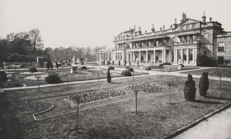
Contemporary accounts (JFA, THBHA 1878, 8) note the beds were cut in turf and enclosed with stone edging. There were numerous dwarf and standard roses and clipped evergreens (Figure 15), which by 1908 were half-circular clipped holly trees. Several broad paths intersected the flowerbeds and much of the garden statuary that Grimston Park was famous for at this time was displayed here. Some sculptures in Carrara marble were considered masterpieces and possibly collected by the second Lord Howden (Country Life 1940a). However, most of the statuary, urns and vases were sold in 1962. The ground floor colonnade and first floor balcony on the south side of the house would have provided excellent views across these formal gardens.
The West Front garden, axial to the house, is sunken with stone steps down from the conservatory and on the south side from a long walk. It was surrounded on its west, north and south sides by the pleasure grounds and contiguous with the south terrace garden linked by a walk. A black and white photograph taken in 1870 (Figure 14) shows an intricate design of geometric beds surrounded by gravel paths, which corresponds with the layout on Nesfield’s ground plan proposal dated 1843. It is not certain if the design contained coloured gravels, often seen in Nesfield’s designs, or low growing plants, or turf. Later photographs taken in 1900 (Leyland, 13) show the beds planted with taller plants. An account in 1880 records 30,000 plants were required to fill the beds of the gardens at Grimston Park (Gardeners’ Chronicle 1880, 300).
Designed as a rosarium, the garden was planted with standard roses numbering up to 450 (ibid), and small rose arbours, which, together with a central sundial, were designed to give the sunken garden some height. By 1908 (Gardeners' Chronicle, 66) the beds were removed and grassed over and the lawn was used for croquet and other games. At the western end was a circular basin and fountain (see 4.11.1). On the northeast side of this garden stands the Orangery (see 4.7.3), which is now converted into a summerhouse.
The two gardens were linked by a long (260m), straight walk along the edge of the sunken rose garden and across the south terrace, extending eastwards to the west side of the walled garden, where through an ornate gate a curved yew hedge surrounded a statue of Venus (Country Life 1901, Vol 10, 464, countrylifeimages.co.uk, image no. 1095234, accessed 27 July 2017; Country Life 1940a, Fig. 4). Flanking the walk at its western end were two statues representing lions attacking a bull and a horse. Here the walk was punctuated by a large sycamore tree, underplanted with ferns. It then continued in a more sinuous fashion towards Emperors’ Walk (Gardeners’ Chronicle 1880, 300; Gardeners’ Chronicle 1881, 468-9, Fig. 87). The sycamore was described (Gardeners’ Chronicle 1908, 66) as: ‘21 feet in circumference 4 feet from the ground, the lowest limb extending 44 feet from the bole. The tree branched into four main stems.’ It was declared unsafe following gales in December 1906 and was removed.
Pleasure Grounds
The pleasure grounds, gardens and walks extended to nearly 40 acres (16 hectares) in 1872. The area was bounded by the carriage drive on the north and entirely surrounded the house, stable courtyard and walled garden (Figure 7). The deciduous woodland with shrubs had numerous straight and sinuous walks arched overhead with yews and box; some had areas of open grass glades beside them, under planted with Selaginella denticulata (Gardeners Chronicle 1880, 300; Gardeners’ Chronicle 1908, 66). On the western side, beyond the formal gardens, paths led to Emperors’ Walk, surrounded by woodland with copper beeches and shrubs such as golden yews (ibid). Northwest of Emperors’ Walk was a lodge positioned beside a walk that led to the carriage drive. It lay along the former carriageway that was removed when the pleasure grounds were extended.
Another walk extended from the south side of the walled garden through the pleasure grounds and then parkland, towards Kirkby Wharfe church, named ‘Church Walk’ on the 1893 25” Ordnance Survey map. Within this eastern area of the pleasure grounds there is also a sunken dell (SE 5016 4121), perhaps a former stone quarry, which was adapted to form a garden feature. In 1908 (Gardeners’ Chronicle, 66) its sides were covered in native ferns. The 1893 25” Ordnance Survey map depicts two paths leading to the dell with steps on its northern side. There was a stone feature to the north of the dell and another feature marked in its centre was a Coade stone fountain, since removed and preserved elsewhere (John Fielden pers. com.).
Today the extent of pleasure ground woodland planting remains much the same as depicted on the 1893 25” Ordnance Survey map.
The Emperors’ Walk
According to the 1872 sale catalogue, p8: ‘The Emperor’s Walk has on either side marble busts of the Twelve Roman Emperors, and is terminated by a Temple containing a large bust of the Emperor Napoleon the First.’
The walk lay within the pleasure grounds west of the house, reached by a number of paths (Figure 7). Images show a broad, straight gravelled walk, flanked by turf, on which were laid out the 12 statues on pedestals, each separated by a shapely specimen of Irish Yew (Holme 1911, plate 50; Figure 8). At its western end steps led up to the temple and at its eastern end was a statue of Paris offering an apple (ibid. xxvi). Surrounding the walk were grass glades, planting and trees.
The statues in Emperors’ Walk were brought into the Conservatory during the 1950s to preserve them from the worst of the weather. They were sold in 1962, along with the temple from the end of the walk (including its steps) and much of the statuary from the gardens.
Kitchen garden
The date of the construction of the walled kitchen garden is uncertain, but the sale catalogue of 1815, p3, describes it:
The kitchen garden is large and exceedingly productive; it is surrounded by lofty walls coped with stone, and besides espalliers, the walls are abundantly cloathed with choicest fruit-trees now in great perfection, and the North wall has flues to forward the ripening of grapes and other fruit.
The 1872 sale catalogue gives more detail:
The kitchen Gardens are spacious, in excellent order, well stocked with the finest description of fruit trees, and contain Hothouses, Vineries, Orchid Houses and nearly every appliance in glass for raising both flowers and fruit. There is also a cottage for the Head Gardener, and sleeping and living rooms for the workmen.
The walled kitchen garden lies to the east of the house and stable courtyard, where the gardeners’ cottages formed its western end. The 1849 6” Ordnance Survey map provides the earliest depiction, showing an enclosed area with a number of compartments, extending to 0.67 hectares (1.66 acres). The main area, divided internally by a central path, had a single glasshouse inside and a range of glasshouses along the internal north wall with buildings on its exterior. It had another large enclosed garden to the south, also subdivided by a path, and a smaller enclosed garden to the east with trees depicted, suggesting orchards. To the north of the walled garden and adjacent to the riding school were further areas, some with geometrically shaped beds suggesting productive vegetable and flower gardens (Figure 7). The 1872 sale catalogue plan shows a similar layout, but with more glasshouses within the walled garden labelled ‘conservatories’, one a vinery. The area of enclosed slip gardens north of the walled garden changed as raising frames were built; and the garden northeast of the riding school became a lawned laundry drying ground.
In 1880 (Gardeners’ Chronicle, 300-2) the kitchen garden and its glasshouses were described in some detail revealing their extensive nature covering 4 acres (1.6 hectares), and the varieties of produce grown. The enclosed kitchen garden was well stocked with fruit trees, cherries, apricots, peaches, pears and apples, the latter grown as bush trees. Additionally there were open areas of kitchen garden with numerous pits and frames. There were five vineries, three 40 feet by 16 feet (12m x 4.87m) and the rest smaller, some with roots outdoors, others indoors. They contained the following varieties: Black Hamburghs, Lady Downe’s, Gros Colmar, Muscats, Alnwick Seedling and Frankenthal. There were three peach houses 45 ft by 16 ft (13.7m x 4.87m), planted with À Bec, Belle Beauce, Bellegarde, Grosse Mignonne, Royal George and nectarines Balgowan, Elruge and Violette Hative. Figs, Negro Largo and Brown Turkey, were grown outdoors but overwintered in another glasshouse. There were two span-roofed pine houses growing Queens, Smooth Cayenne and Black Prince varieties. One house was dedicated to growing and forcing strawberries, with another small one for orchids. Flanking the glasshouses, against the wall, slate enclosures were erected for melons and tomatoes.
By 1891 a range of external buildings had been added to the north wall, including boiler house and bothy and internal glasshouses with the internal dividing wall removed (Figure 9b). An additional area of enclosed orchard developed wrapped around the southeast corner of the walled garden. An enclosed area to the north had additional glasshouses and frames. By 1908 (Gardeners’ Chronicle, 67) there were twenty-three glasshouses, including the large conservatory; three were used for vines, three for peaches, others for melon, figs, tomatoes and cucumbers, and four were devoted to the growing of carnations.
A history of North Milford and Kirkby Wharfe in the nineteenth century (Theakstone 2014, 101-7) identifies the head gardeners at Grimston Park from 1840 to the early twentieth century (James Wemyss, Frederick Tester, John Richards, William Denning, Henry James Clayton, George Prideaux Bound), followed by Wilf Theakstone and the current present gardener for over thirty years, Peter Davidson.
Numerous newspaper articles in the early nineteenth century reflect the productivity of the walled gardens and the accomplishments of the gardeners. James Wemyss, head gardener under 1st Lord Howden, won prizes at the York Floral Show, York Horticultural Society and Leeds Horticultural Society throughout the 1830s with his anemones, melons, mushrooms and dahlias. Lady Howden also presented the Leeds Horticultural Society with a basket of roses in 1837. A dahlia variety was named after Lord Howden. Mr Wemyss retained his post with the 2nd Lord Howden and exhibited throughout the period of 1840 to 1842 when Decimus Burton was remodelling the house. This suggests that the kitchen garden, providing fruit and vegetables, was not greatly affected by the building work and redesign of the gardens by William Andrews Nesfield. During these two years melons, figs, peaches, pears and cherries were exhibited and won prizes. Along with these, abundant roses were exhibited including ‘a tray of 50 dissimilar roses’ in 1841. By 1845 Mr Wemyss had retired and was replaced by Frederick Tester who continued to exhibit, winning prizes for strawberries, cucumbers, peaches, grapes and China Asters. Mr Clayton’s expertise at growing apple varieties (Red Balsam, Scarlet Cockpit and Lewis’s Incomparable) shows fruit trees were being grown within the shelter of the walled gardens as well as in the open parkland too (Journal of the Royal Horticultural, Society, 1888, 243-4).
Park and plantations
According to the 1872 sale catalogue: ‘The Park contains upwards of 600 acres of land, studded with fine ornamental timber, and thriving plantations.’
The Park
The 1815 sale catalogue (p3) lists the park areas: ‘The North Park’ as meadow, ‘The South and East Park’ as pasture. This division of the parkland areas reflects the position of the house and pleasure grounds lying E-W across the central part of the designed landscape. These meadow and pasture areas retained some field boundary divisions, or their hedgerow tree alignments. In contrast the western area of parkland had numerous scattered trees and irregular tree clumps, as depicted on later maps (Figure 5 & Figure 12).
Comparing the 1849 6” with later Ordnance Survey maps shows that the extent of the parkland changed over time. Parts of North Park that bordered the River Wharfe contracted, and a large swathe of new parkland was added on its southern boundary (Figure 12). Brecks Farm was demolished and a new model Home Farm (later Kirkby Grange) was built on the southern edge of the parkland, as well as a gasworks. It is here that the racing paddocks and stud developed, as described in the 1872 sale catalogue, p8: ‘the south-east corner of the Park are the Breeding Paddocks, with Sheds, formed by the late Lord Londesborough for his Racing Establishment.’ This developed into the Stockwell Stud.
The parkland was well wooded with many single specimen trees and irregular tree clumps with many purple beech noted (Gardeners Chronicle 1880, 300). A visit made in 1878 (THBHA, 7) describes:
many globular-headed trees, such as limes, sycamore and fine old English elms, all of them abundant and in luxuriant state of growth.......numerous masses of trees, groves and groups being arranged as to afford beautiful glades of grass land.
At the highest point in the parkland (42m AOD) is the ornate observatory tower, designed by Decimus Burton and forming an eyecatcher. It had a gravel path leading to it across the parkland from the pleasure grounds, which has since been removed (4.7.8) (Figures 10 & 12).
Today large parts of the parkland are retained as pasture with many mature single specimen trees and some tree clumps still surviving. This pasture has good survival of earthworks of medieval ridge and furrow ploughing (Google Earth images, accessed 27 July 2017). In contrast large areas of the southern parkland are ploughed and under arable cultivation. Parts are used for breeding pheasants, carrying on a tradition on the estate of shooting game, which attracted royal visits in past times, as noted in the estate game books (John Fielden pers. com.).
Woods and Plantations
The 1815 sale catalogue lists numerous plantations and coppiced woods totalling 152 acres (61 hectares) in Kirkby Wharfe. However, without a contemporary plan it is difficult to identify their location and context within the designed landscape, as opposed to the wider estate. A plan of 1872 (JFA, Grimston Park Office) shows Grimston estate extended northwards to Tadcaster, southwards to include North Milford, eastward to include Kirkby Wharfe and Honnington on the east bank of the River Wharfe, and westwards to include Grimston Hills. This last has large areas of woodland with remnants of ancient woodlands, which enhance the views outwards from the designed landscape (http://www.ancient-tree-hunt.org.uk/discoveries/interactivemap accessed 27 July 2017) (North Yorkshire County Council HLC: HNY5470 & 5469).
By 1872 the sale catalogue describes the estate as ‘richly-timbered’ and ‘The Woods and Plantations cover about 150 acres of land, and are full of vigorous and thriving trees.’
The Ordnance Survey maps from 1849 onwards provide the extent and location of the woods and plantations within the parkland, and their names: Broad Row Plantation, Limekiln Wood, Tasker Wood, Crow Wood, Ladyflats Belt, Ladyflats Plantations, Brecks Plantations, Dish Hole Plantation, Beech Plantation and Sunnybank Plantation. Tasker Wood also has a nursery area labelled on the 1849 map. There are very few changes over time to the footprint of these woods and plantations, apart from the addition of narrow shelterbelts. By 1890 Ladyflats Belt, along the eastern boundary and southeastern corner, was added, screening the views towards Kirkby Wharfe village. Broad Row Plantation on the southwestern corner, bordering the Tadcaster to Ferrybridge turnpike road (A162), was extended. On the northern boundary Tasker Wood was developed by 1891, following the contraction of the parkland to exclude the floodplain by the River Wharfe. The extension of the parkland on the southern side saw irregular clumps of trees being added both within the parkland and along its fringes, such as half clumps planted along Raw Lane (Brick Kiln Plantation and Bar Plantation), which framed and enhanced the views. Although the woods and plantations have been managed and replanted, they maintain their same footprint; only the smaller plantations across the southern parkland have been removed (Figure 11).
Water
Fountain approximately 30 metres to west of house [Listed Grade II, NHLE: 1168063]
Approximately 30 metres to the west of the house, in the sunken rose garden, is a circular pond with a fountain. It consists of an ashlar basin surrounding an artificial stone fountain in the form of a shallow urn on an octagonal plinth, surmounted by three dolphins with tails entwined supporting a shell-like bowl with cherub. The original fountain was installed in c.1840 but was badly frost damaged and has been restored as close to the original design as possible.
Ponds and reservoir
There are several small ponds and a reservoir in the parkland, seen on the 1849 6” Ordnance Survey map. One oval pond north of Rose Cottage (SE 4934 4929) is fed by a spring. A rectangular pond, possibly a fishpond, lay adjacent to the River Wharfe (SE 5005 4215), but has since been removed. Other small ponds are likely to be dewponds for cattle, given the context of the underlying limestone geology. One adjacent to Kirkby Grange (SE 5008 4043) was enlarged to a polygonal shape with a small island, but is now filled in, its relict shape retained in the field boundaries.
Adjacent to the observatory tower is a reservoir at 44m above AOD, the highest point in the parkland, and first depicted on the 1893 25” Ordnance Survey map. Water was pumped to the reservoir from a deep well at the Home Farm. The water was then fed downhill to tanks and cisterns, which supplied water to the house and other buildings. Water from other wells and springs in the park was harnessed to supplement the domestic water supply (JFA, 1872 sale catalogue, 7).
Within the parkland, west of Kirkby Wharfe village (SE 5054 4088), the 1849 6” Ordnance Survey map shows a pump and two buildings, one with a small garden plot. This may have been a pumping house and dwelling, in use prior to the construction of the reservoir. The buildings were demolished and Ladyflats Belt planted across the area as seen on the 1893 25” Ordnance Survey map.
River Wharfe and fishery
The parkland has no large expanses of water or lakes; instead the River Wharfe, lying to the north and east of the house, was a significant part of the landscape running through the Grimston Park estate and bordering the parkland. Apart from its aesthetic qualities adding to the picturesque style of the parkland, it was navigable for transporting goods and for recreation, and was a valuable resource as a salmon fishery. In the 1872 sale catalogue (p10) it was noted as a river abounding with salmon, trout, grayling and lampreys.
Books and articles
Blome, R. 1673 Britannia, or the geographical descriptions of the kingdoms of England, Scotland and Ireland.... London, Tho. Roycroft.
Bogg, E. 1904. Two Thousand Miles In Wharfedale: a descriptive account of the history, antiquities legendary lore, picturesque features and rare architecture of the vale of the Wharfe from Tadcaster to Cam Fell. London, John Heywood.
Buck, S. 1979. Samuel Buck's Yorkshire sketchbook: reproduced in facsimile from Lansdowne MS.914 in the British Library, with an introduction by Ivan Hall. Wakefield, Wakefield Historical Publications.
Country Life. 1901. Country Homes, Gardens Old and New: Grimston Park, The Seat of Mrs John Fielden, Vol 10, 464-70.
Country Life. 1940a. Country Homes, Gardens Old and New: Grimston Park - I, Yorkshire, The seat of Captain John Fielden. Vol 87, 252-56.
Country Life. 1940b. Country Homes, Gardens Old and New: Grimston Park - II, Yorkshire, The seat of Captain John Fielden. Vol 87, 276-80.
Evans, S. R. 2007. William Andrews Nesfield (1794-1881) Artist and Landscape Gardener. Thesis submitted to the University of Plymouth in partial fulfilment for the degree of Doctor of Philosophy. Falmouth, University College.
Harvey, J. C. 1986. Houses of Glass A Nineteenth-Century Building Type. Cambridge, MIT Press 1986.
Holme, C. 1911. The Gardens of England in the Northern Counties. p xxv, xxvi, pls 49-51. London.
Horgan, D. M. 2000. Wiganthorpe Hall, Nr. Terrington, N. Yorks. Descent of Ownership.
https://oldterrington.files.wordpress.com/2011/11/dm-horgan-history-of-wiganthorpe.pdf
Accessed 21 Feb 2018.
Langdale, T. 1809. A Topographical Dictionary of Yorkshire; containing the name of all the towns, villages, hamlets, gentlemen’s seats &c. in the County of York. Northallerton, J. Langdale.
Leyland, J. 1900. Gardens Old and New: The Country House in its Garden Environment, Vol II, 9-13. London, Country Life.
Loudon, J. C. 1836. Gardener’s Magazine and Register of Rural and Domestic Improvement, Vol II, New Series. London.
Loudon, J. C. 1844. Arboretum Et Fruticetum Britannicum: Or, The Trees and Shrubs of Britain, Vol I. London, H. G. Bohn.
Macpherson, W. 1841. Treatise on the Law Relating to Infants, Volumes 1-2, xxiv-v. London, Alexander Maxwell.
Pevsner, N. 1974. Yorkshire, The West Riding, The Buildings of England. Second edition revised by E. Radcliffe. Harmondsworth, Penguin.
Theakstone, J. 2014. Grimston, Kirby Wharfe and North Milford in the Nineteenth Century. Burnley, Nu-Age Print & Copy. p101-7
Wollerton Dodworth Associates. 1999. Landscape Assessment of Selby District prepared for Selby District Council
Wragg, B. 2000. Ed. Giles Worsley. The Life and Works of John Carr of York. York, Oblong.
Primary sources
John Fielden archive (JFA)
| Sale catalogue: The Particulars of Grimston House Estate and Tithes, near Tadcaster | 1815 |
| Sketch: Seat of the right honourable John Francis Carodoc Lord Howden | 1839 |
| Sketch by R. M. Grimston Hall - Yorkshire. The Country Seat of the Right Hon Lord Howden | 1848 |
| Sale catalogue: The Grimston Park Estate, Yorkshire | 1872 |
| Sale catalogue: The residue of the Grimston Park Estate, Yorkshire | 1873 |
Grimston Hall and Park, the Yorkshire Residence of John Fielden Esq. in Todmorden and Hebden Bridge Historical Almanack, 4-17
| 1878 |
Richard Best archive (RBA)
Ground plan of Rosarium for Grimston Park by William Andrews Nesfield, 1834
National Archive (NA)
| PROB 11/696/495 Will of Edward Stanhope of Grimston, Yorkshire | 1739 |
| PROB 11/752/389 Will and codicil of William Garforth of York, Yorkshire | 1744 |
IR 30/43/244 Tithe map for North Milford, Grimston and Kirkby Wharfe [Source: http://www.thegenealogist.co.uk/ accessed 9 February 2018] | 1849 |
Tadcaster Historical Society (THS)
| Plan of new road in townships Kirby Wharfe, North Milford and Ulleskelf | 1840 |
| Thackrah, Maurice: Ladyflats Roman Building at Kirkby Wharfe | 1972 |
West Yorkshire Archives Services, Leeds (WYAS)
| WYL210/82/7 | Sir Walter Vavasour & Mr George Townend, settlement of land in Grimston. | 1794 |
| WYL210/82/57 | Indenture – Right Hon Lord Hawke & George Townend for conveyance of land and messuage in Kirby upon Wharfe | 1790 |
| WYL210/82/65 | Indenture – William Garforth, Elizabeth Garforth, George Townend & Richard Townend, sale Kirkby Wharfe and Grimston for £33,000 | 1790 |
WYL210/82/66
| Indentures – William Garforth Marriage settlement William Garforth & wife Frances Elizabeth Dalton William Garforth & George Townend purchase manors Kirby Wharfe and Grimston | 1777 1778 1790 |
| WYL210/82/no number | Indenture – William Garforth, George Townend, marriage Ann Townend to John Moore | 1794 |
| WYL210/82/78 | Release of the manors Grimston and Kirby Wharfe to Sir John Francis Cradock | 1819 |
Maps
Christopher Saxton map (Eboracensis Comitatus f.61) 1577
John Speed, map of West Riding of Yorkshire 1610
John Warburton, map of Yorkshire 1720
Thomas Jefferys, map of Yorkshire, plate 13, 1771
Ordnance Survey 6” surveyed 1845 to 1846, published 1849
Ordnance Survey 6” surveyed 1890, published 1894
Ordnance Survey 6” revised 1906, published 1909
Ordnance Survey 25” surveyed 1891, published 1893
Newspapers & Magazines
Gardeners’ Chronicle, 4 September 1880, Vol 14, New Series, p300-2, Fig. 55, p305
Gardeners’ Chronicle, 8 October 1881, Vol 55, New Series, 468-9, Fig. 87
Gardeners’ Chronicle, 25 July 1908, Vol 44, Third Series, 66-7
Gardeners’ Chronicle and New Horticulturist, 6 July 1872
Journal of the Royal Horticultural Society, 1888, Vol X, 243-4
Leeds Mercury, dates between 1837 and 1841
Morning Post, dates between 1831 and 1856
York Herald, dates between 1831 and 1856
Yorkshire Gazette, 23 July 1864
Figure 1 – Location of Grimston Park west of Kirkby Wharfe and south of Tadcaster. Ordnance Survey map, Leeds (Hills) Sheet 70, revised 1896, published 1898. Map reproduced by permission of the National Library of Scotland.
Figure 2 – Grimston settlement in the former West Riding of Yorkshire. John Speed map of West Riding of Yorkshire 1610. By permission of Sheffield Local Studies Library: Picture Sheffield www.picturesheffield.com.
Figure 3 – Grimstone village west of the house with road towards Bella Hall next to Kirkby Wharfe. Thomas Jeffery's map of Yorkshire 1771, plate 13. Source: North Yorkshire County Record Office.
Figure 4 – Grimston House in 1839, designed by John Carr. Source and copyright © John Fielden Archive.
Figure 5 – Western approaches and lodges to Grimston Park 1840 onwards. Ordnance Survey 6” map, surveyed 1846-7, published 1849. Map reproduced by permission of the National Library of Scotland.
Figure 6 – North facade of Grimston Park in 1861, designed by Decimus Burton 1840. Rock & Co, Vol. 10, No. 3316. Reproduced by permission of North Devon Athenaeum https://northdevonathenaeum.org.uk
Figure 7 – Formal gardens to south and west of the house surrounded by pleasure grounds with The Emperors’ Walk to the west. Ordnance Survey 6” map, surveyed 1846-7, published 1849. Map reproduced by permission of the National Library of Scotland.
Figure 8 – Postcard 1908 showing Emperors’ Walk lined with marble busts of the 12 Caesars on pedestals and temple beyond. Source and copyright © John Fielden Archive.
Figure 9a – Formal terrace parterre to the south and walled gardens to the east of the house by 1847. Ordnance Survey 6” map, surveyed 1846-7, published 1849. Map reproduced by permission of the National Library of Scotland.
Figure 9b – Enlargement of the south terrace parterre and kitchen gardens with glasshouses and orchards by 1891. Ordnance Survey 25” map, surveyed 1891, published 1893. Map reproduced by permission of the National Library of Scotland.
Figure 10 – Pleasure grounds extending west and east of the house, north to the carriage drive and tennis courts south of the terrace parterre. Ordnance Survey 6” map, surveyed 1906, published 1909. Map reproduced by permission of the National Library of Scotland.
Figure 11 – Extent of Grimston Park parkland, woodland and plantations. Map background © OpenStreetMap contributors https://www.openstreetmap.org/copyright
Figure 12 – Changes to the extent of the parkland between 1849 and 1890. Ordnance Survey 6” map, surveyed 1890, published 1894. Map reproduced by permission of the National Library of Scotland.
Figure 13 – Grimston Tower in 1872, designed by Decimus Burton c.1840, with gravel path through parkland from the pleasure grounds. Source and copyright © John Fielden Archive.
Figure 14 – Sunken rosary garden and fountain in 1870, designed by William Andrews Nesfield. Source and copyright © John Fielden Archive.
Figure 15 – South facade Grimston Park mansion and formal terrace parterre in 1870, designed by William Andrews Nesfield. Source and copyright © John Fielden Archive.


