Note although the present town is spelt Guisborough, the Priory and the Hall are historically spelt ‘Gisborough’.
The building of Gisborough Priory in the early 12th century has been the major influence on the designed landscape that has surrounded it for the following 900 years. While only a small part remained after its dissolution in 1540, from the late 17th century onwards, the priory has determined how the grounds were laid out by the Chaloner family first for the old Gisborough Hall and then Longhull (later Gisborough Hall). When funds permitted, largely from the local alum and then ironstone mines, succeeding generations of Chaloners have updated the grounds to reflect the current gardening fashions. What makes this site different is how they always incorporated the priory’s ruins into the design.
The first designed landscapes had been laid out in and around the priory by the early 16th century and included a cloister garden, cemetery orchard, a prior’s private area (possibly around the dovecote), together with an enclosed area of 70 acres immediately to the east and a hunting park just under a mile to the southwest. William Chaloner decided to build a new house c. 1680 on the former priory site and used parts of it in the design of the adjacent grounds including the former cloister garden, dovecote and fishponds, with the remaining east wall of the priory church as a focus point.
Over the next 250 years this area was altered according to the gardening trends of the time. First, the formal garden elements were removed in the late 18th century and replaced with informal pleasure grounds of trees and shrubs. The extant ‘Lime or Monk’s Walk’ of a double row of lime trees in a diamond pattern was put in the late 1790s. By the middle of the 19th century and the development of pleasure grounds around the new Longhull, the priory grounds once again had defined garden areas, both productive and aesthetic. In the Edwardian period, an Italian garden with lily pond, a formal rose garden and other decorative areas were added in the southern section, together with a new range of glasshouses.
With the rebuilding of Longhull to the east of the priory site in the late 1850s, the area around it was turned into parkland and plantations lined the two entrances from the north and south, where lodges were added in the first decade of the 20th century. Immediately next to the hall, a terraced garden area designed by William Brodrick Thomas was constructed at the same time as the rebuilding of the hall c. 1857. This was modified c. 1905 when the hall building was expanded and renamed Gisborough Hall. The majority of the site remains as parkland, woodland or garden areas and provides an important green space for the expanding town of Guisborough.
For information on Gisborough Priory Project, visit https://gisboroughprioryproject.org.uk/
Estate owners
The settlement of Guisborough had been laid waste following the Norman Conquest and in 1086, was jointly owned by the King, Earl Hugh of Chester, Count Robert of Mortain and Robert Malet (https://opendomesday.org/place/NZ6116/guisborough/ consulted 25 October 2022). By 1119 and the foundation of the Priory, most of these lands belonged to Robert de Brus, its founder (Harrison and Dixon 1982, 11). He had been granted these by the king, after his arrival in England from Normandy in 1100 (Blakely 2005, 8). Following the dissolution of the monastery in 1540, the priory and its lands reverted to the Crown and were leased to Thomas Legh on the 21 November 1541 for 21 years. This lease was transferred to Thomas Chaloner in 1547 and on the 31 October 1550, it was sold to him (Ord 1846, 578).
Thomas Chaloner died in 1565 and his son, Thomas junior, inherited the estate although he and his son, William, who died in 1641, lived elsewhere. William’s nephew and successor, Edward, is thought to be the first member of his family to live in Guisborough from c. 1655, however this was at Park House, northwest of the town. By c. 1700 though, the Chaloner family had moved to a new property next to the old Priory grounds, probably built by William following his accession to the estate in 1680. They remained there until c. 1797 when they went to live at Longhull, which was originally farmstead to the east that had been rebuilt.
In 1825, Robert Chaloner was declared bankrupt and moved to Ireland. His son, Robert junior, managed to improve the family finances after inheriting the estate and on his death in 1855, it was his brother, Captain (later Admiral) Thomas Chaloner who took possession. As Thomas had no children, on his death in 1884, his great nephew Richard (né Long) inherited, later becoming Lord Gisborough. His descendants still own the estate.
Key owners responsible for major developments of the designed landscape and dates of their involvement:
Gisborough Priory 1119 – 1540
William Chaloner 1680 – 1715
Edward Chaloner 1715 – 1737
William Chaloner 1737 – 1754
William Chaloner junior c. 1766 – 1793
Robert Chaloner 1796 – 1825
Robert Chaloner junior c. 1846 – 1855
Admiral Thomas Chaloner 1855 – 1884
Richard Chaloner (né Long, 1st Lord Gisborough) and Margaret Chaloner c. 1902 – 1938
Early history of the site
Gisborough Priory was founded in 1119 by Robert de Brus on a site next to the town’s church. He endowed it with an initial grant of c. 2,500 acres of arable land, together with pasture, meadow and woodland in and around Guisborough (Ord 1846, 177). Following a fire in 1289, the priory church was rebuilt and on 1 July 1344, the Priory was granted a licence to crenellate their dwelling place (PRO 1902, 316). It is thought that these grounds covered c. 90 acres and were enclosed by dikes and walls to protect them.
On 20 October 1239, Peter de Brus granted the Prior and the Canons of Gisborough, the right to
‘enclose the wood called Prior’s Cliff with dyke, wall or hedge, so that beasts from outside or wild animals enter not; and that they may make thereof a park if they please’ (YAS 1925, 56).
Whether they made the park at this time is not known, but they were clearly hunting as 7 years later, de Brus agreed that he, his successors or foresters would not
‘stop the men or dogs of the said Prior or his successor anywhere within the limits of their own territory of Giseburne’ (Ord 1846, 567).
In 1263, the Priory was granted ‘free warren’ or royal approval to hunt on their lands by Henry III (Surtees Society 1889, 132-3). This park was possibly expanded in the reign of Edward III between 1327 and 1375, as the priory was allowed to
‘enclose their wood called the Clyve…and fourscore acres of land contiguous to the same wood, and make a park thereof’ (Ord 1846, 572).
On the 22 June 1376, the Prior complained that certain persons had come
‘by night to Gysburn, assaulted him, followed him to the priory and besieged him therein…broke his closes and houses there…broke his park at Gysburn and entered his free warrens there…hunted in these, felled his trees and underwood at Gysburn, rooted up his heath there…carried away…deer from the park, and hares, conies, pheasants and partridges from the warrens’ (PRO 1916, 329-30).
The lease granted to Thomas Legh on 21 November 1541 (Ord 1846, 574) described the priory grounds, following its dissolution:
The house and site of the late Priory of Gisborn…together with all houses, buildings, barns, pigeon-houses, orchards, pomeries [apple yards], gardens, waters, lakes, fish-ponds, land and soil being within the site…of the same late Priory, containing by estimation two acres, and one close of pasture called Dereclose, and a pasture called the Holme, within the same close of pasture, containing in the whole…seventy acres, one close of pasture called Appulgarthe, and the pasture called the Withes and Dovecotegarthe, adjacent to the same close, containing…six acres
These areas are shown on Figure 1. The Applegarth was probably a cemetery orchard and the area known as Withes may have been used for growing willow. Dovecotegarthe is possibly the garden of the priory mentioned in one of the charters relating to a ‘toft which lies on the north side of the Garden of the said Prior and Convent of Gyseburn’ (Surtees Society 1889, 73). There was also the cloister garden that was later used as a bowling green.
An additional 36 acres is mentioned that lay ‘within land and park called the Clyff’ (ibid). In the survey conducted in 1535, it was stated that the park was enclosed ‘partly with a palisade, partly with hedges and partly with walls’ (Harrison and Dixon 1982, 87). The charter given by Edward III for a park (see above) had stated that the open ground was 80 acres next to a wood. Figure 2 shows its likely boundaries based on later fieldnames (Kemplar garths, Harve Ing, Broad Fields, Mere Close & Hunter Hills). Given part was already tenanted by the priory’s dissolution, it may have ceased to be an active deer park by this stage.
A survey from 1602 of the manor of Guisborough (56B) showed that part of the priory grounds were also now tenanted:
‘Robert Walker holds a house and 2 acres at the deer close, worth 20s, paid 10s…Maurice Long 37 acres at the deer close carre, the applegarth & wythe 12 acres, between Northoutgate & Hewbanke 14 acres paid £9 1s 4d, worth £16 11s…Widow Sergeaunt 20 acres beyond deer close carre, the bank 10 acres’.
There is no reference to other parts of the grounds being tenanted although Sir Thomas Chaloner lived elsewhere. A kinsman, also Thomas Chaloner, was living in Guisborough by 1592 as he was overseeing the family’s investment in the new alum mines (Harrison and Dixon 1982, 87). There is no mention of the later Park House in either the grant of 1541 or the 1602 survey, so he may have been staying at what remained of the priory. In a letter sent to Sir Thomas Chaloner between 1603 and 1607, the unknown writer described Guisborough and the surrounding lands. From this, it would seem parts of the priory buildings were still standing (Nichols 1853, 406):
‘at the west end of the abbey church, over a door in a steeple, are certain ancient letters circular-wise written…Two gatehouses had lodgings and all house of offices appertaining to a dwelling house, whereof two of the Bulmers, knights, within memory of man, were porters…Walking in the chapter house at Gisborough, I remarked a broken pillar (ibid, 425)
He also mentioned that ‘[the people of Guisborough were] day and night feasting, making matches for horse-races, dog-running or running on foot, which they use in a field called the Deer Close’ (ibid, 409).
After inheriting the property from his uncle in 1641, Edward Chaloner decided to move his family to Guisborough c. 1655. They lived though in the newly built Park House to the northwest of the town, rather than in buildings in the priory grounds. A print from 1661 (Figure 3) shows that the priory was now quite ruinous, with only the east wall standing. Edward Chaloner may have wanted to create the small park around the house, which had c. 170 acres of open ground and 75 acres of woodland, shown on the map by Warburton c. 1720 (Figure 4). Park House was a substantial building having 14 hearths in 1662 (Harrison and Dixon 1982, 121) that had increased to 17 by 1673 (ibid, 109). It remained as a secondary home for the Chaloners, who used the park as hunting grounds until the early 19th century when it became farmland.
Chronological history of the designed landscape
c. 1680 – 1792
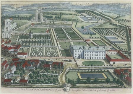
William Chaloner inherited the estate in 1680 and sometime before c. 1700 had built a large mansion and grounds next to the former priory site that was depicted by Johannes Kip and published in 1707 (Figure 5). Clearly an expensive undertaking, it is likely to have been paid for by the revival of alum mines on the Chaloner land from 1679 (Harrison and Dixon 1982, 105). Its design may have been inspired by Ingleby Manor, the family property of his wife, Honoria Foulis. It too had a long terrace on the side of a bank leading to a stream and was also depicted by Kip (Wickham 2022).
Parts of the former priory’s designed landscape were incorporated into the layout including the cloister garth (bowling green), dovecote, probably the fishponds and the wider parkland to the east. In 1704, their Buckinghamshire estates at Steeple Claydon were sold, providing more funds. The alum mines in Guisborough continued to provide revenue until 1736, when some of the later features seen on the 1773 estate map (Figure 6) such as the diamond shaped garden were put in place, possibly by William Chaloner senior before 1754.
After a break of 30 years, the alum mines were again reopened in 1766. William Chaloner had come of age then and was probably making changes to the designed landscape in line with the more informal gardening style of the period. By 1773, the two smaller formal ponds southeast of the hall had been removed and replaced with plantations. There was a new building (possibly a greenhouse) south of the diamond-shaped garden and a nursery near Longhull. The site of the abbey (‘Abbey Garth’) was planted with two rows of trees and these are shown on the engraving from Grose’s Antiquities of England and Wales published in 1785 (Plate 2, Figure 7).
By c. 1792, the formal gardens immediately next to the hall had been removed and replaced with a new pleasure ground that would have consisted of paths, shrubberies and trees. The pond opposite the hall in ‘Fountain Garth’ had been filled in. There was a new walled kitchen garden (‘Melon ground’) and the wider landscape to the east had been opened up to form an area of parkland (c.1799 estate map, Figure 8). While the extant accounts (85 & 86) detail regular payments to the gardener and his labourers in 1773 (£17 10s 12d, 20 April to 4 January) and 1774 (£39, 8 January to end September), there is no evidence that a specific improvement plan had been drawn up. The gardener, Alexander Campbell, had been there since 1748 as his burial record in January 1803 noted he had been ‘fifty-four years Gardiner in Mr. Chaloner’s family’ (Harrison and Dixon 1982, 161). He would therefore have had the experience to effect these and later changes.
1793 – 1846
Robert Chaloner inherited the estate in 1796, as his elder brother, Thomas, had died without issue. In 1797, due to problems with damp at the Hall, he decided to relocate to the Longhull farm to the east, where he built a new house. This gave him an opportunity to develop the landscape around it. From 1796, he built a small new garden to the northwest, added pleasure grounds around the building, increased the plantations and opened up the fields to form parkland (1826 estate map, Figure 9). In the gardens of the former hall, the double avenue of limes in a diamond shape (‘Lime’ or ‘Monk’s Walk’) was probably planted in the late 1790s, given the estimated age of the oldest remaining trees. In the eastern part of the garden next to the bowling green, a new greenhouse was built in 1797 (87). On 29 December 1798, Geo. Havelock was paid £21 7s for building a new garden wall besides the old greenhouse (ibid) to enclose that area. The old hall was finally demolished in about 1805 and the area planted with trees and shrubs.
Robert Chaloner went bankrupt in 1825, after many years of financial problems with the estate. He left to live in Ireland and the estate was run by trustees. Sir Robert Lawrence Dundas, his brother-in-law, was living at Longhull until at least 1838 (The National Archives PROB 1/2010/194, will of Sir Robert Lawrence Dundas). Dundas moved to a new house at his estate in Loftus c. 1840 and the property was unoccupied until late 1842. According to an obituary notice for Frances Laura Chaloner,
‘shortly after Mr. [Robert] Chaloner’s death [7 October 1842], Mrs. C. took up her residence at the family mansion Longhull, near Gisbro’, intending to pass the remainder of her life in the place…but which, through unavoidable circumstances, had been for the last few years deserted’ (York Herald, 2 December 1843).
Throughout this time, the grounds were maintained by the gardener, John Brown. With the return of Robert Chaloner junior, who inherited the estate, the grounds started to be developed again from c. 1845, most notably with the draining and levelling of the Island Pond in April of that year (91).
1847 – 1869
A survey from 1847 (57, Figure 10) showed that an area of former fields between the priory and Longhull had been taken ‘in hand’ (Nos 461, 462 and 493). Totalling just under 35 acres, the aim was to make this into open parkland and link the two sites. The former ‘Melon ground’ together with its greenhouse had been cleared and the latter removed. The double lime avenue was now indistinct with additional trees around it, suggesting that it had not been managed for some time.
Robert Chaloner gradually managed to revive the family fortunes that was further enhanced by the development of ironstone mining at Belmont and the arrival of the railway in 1854 (Harrison and Dixon 1982, 128). By 1853, the new large area of parkland was complete with some earlier plantations removed on its boundaries. The pleasure grounds had been extended around Longhull and the walled garden to north of the stableblock had been removed, as a new kitchen garden was being developed at the priory site (1st edition 6” OS map, Figure 11). The gardener, John Brown, had died in 1852 and he was replaced by John Pearcy, who was taken on presumably to oversee the work in the grounds.
Chaloner commissioned a plan of the old hall gardens in 1854 that showed a more formal layout again, reflecting the changing gardening trends. Long standing features such as the Lime Walk appear to have been re-instated with possible replanting and the path along the late 17th century terrace had been extended to the north of it (Figure 12). In the accounts, there are references to rebuilding of walls in 1847 (91) and expenditure on trees, fruit trees and shrubs between 1849 and 1852 from the Rose Hill Nursery at Yarm and other sources (ibid). Chaloner commissioned a new greenhouse complex from Weeks & Co in April 1855 to the north of the site of the old hall near Bow Street (174, see Section 4.9).
Robert died on 15 May 1855 and his brother, Thomas, succeeded him. Soon after there were major works at Longhull and its surroundings, that may have been planned by Robert. Thomas employed the architect, Mr Teulon (probably Samuel Sanders who died on 2 May 1873, see reference in Atkinson below), in 1857 to remodel the hall and the garden designer, William Brodrick Thomas, to lay out the immediate grounds around it probably soon after. W.B. Thomas worked with the architect William Milford Sanders (Samuel’s brother) on a number of commissions in Northamptonshire from 1859 (Pointer 2022, 12-3). It is possible therefore that he was introduced to Thomas Chaloner by the Teulon brothers.
Thomas’ plan focused on the new carriageway to the stables and remodelled hall with a detailed planting plan of trees and new gardens to the south and east of the hall, surrounded by a stone balustrade (Figure 13). In the account book (93), there is an entry for W Jackson, Shrubs and trees, £144 on 3 May 1858 under the ‘Mansion Acct’. This was from Wm. Jackson & Co. (Cross Lanes Nursery) based in Scruton, near Bedale. It was a large order likely to be for both Thomas’ plans but also the extensive plantation to the north (‘Horse Parks Wood’) that replaced the pleasure grounds (1869 survey, Figure 14). A new approach was put in from the north from Church Lane that is mentioned in J. C. Atkinson’s History of Cleveland, Volume 2 (published in 1877 but written c. 1874):
‘Up to some 12 or 15 years ago, the house [Longhull] was of no great mark…It has now, however, been pulled down and rebuilt from designs by, and under the superintendence of, Mr Teulon, a well-known architect, since dead…Within the last two or three years, moreover, a new approach from the direction of the Cemetery (or the northward) has been made, and new plantations laid out which are of such a character as materially to add to the attractiveness of the place’ (43).
By 1869, there was also a new area of parkland (‘Front Park’) of 42 acres south of the Whitby Road allowing for a clear view from the hall to the Cleveland Hills, together with new plantations around Hall (or Great) Pond. In 1867, Chaloner cleared the area around the priory ruins (The Building News, 18 October) including the trees that had been planted the previous century. It was possibly at this time that a new haha (sunk fence) was put in behind east end of priory church, allowing a clear view of it from Longhull.
1870 – 1914
Thomas Chaloner died on 20 October 1884 and the estate was inherited by his great-nephew, Richard Long (later Chaloner and 1st Lord Gisborough). He and his family remained in Wiltshire until 1902, as Thomas’ widow, Amelia, continued to live at Longhull until her death on 8 March of that year. Little was done to the estate in this period, apart from the dog kennels north of the Hall pond being removed by 1893. Richard, his wife, Margaret, and family moved into Longhull, which they remodelled and renamed Gisborough Hall. They also embarked on a series of changes before 1913, including adding the North Lodge and South Lodge to their respective existing entrances, creating a new plantation around the North Lodge and expanding the Horse Parks Wood and Horse Paddocks Plantation. The area immediately south of the hall was altered with parts of stone balustrading removed before 1907.
In the priory gardens, they developed a new area with glasshouses and frames c. 1902 (see Section 4.9) where the Island Pond had been. Further garden areas were developed between 1902 and 1913: the ‘Italian garden’ with a lily pond, a rose garden before 1906, a long herbaceous border next to the terrace, ‘Lady Gisborough’s tea garden’ and ‘Michaelmas Daisy Garden’ at the eastern end of terrace. A boathouse was added to eastern end of Hall Pond before 1908 and some trees were planted in the Lime Walk, possibly to replace those that had died. The last of the remaining fruit trees were removed from the central part of the dovecote area, as was the late 18th century glasshouse next to the grounds of the priory and one of the 1855 glasshouses near Bow Street (Rev edition 25” OS map, Figure 15).
Later history
Just before the First World War the priory garden site was leased to Teddy Clarkson, who was responsible for maintaining the gardens but was able to sell produce and flowers from it. Open to visitors before the war in the summer, they were regularly open to the public in 1920s for an admission fee. In 1932, the Chaloner family gave care of the priory site to a government body (Ministry of Works, later English Heritage). The Laurence Jackson school was built on northern parkland in late 1950s and in 1960, the Church Hall on Bow Street was erected on part of the former gardens next to the 1855 glasshouse.
Location
Gisborough Hall and Priory are in the town of Guisborough, 8.5 miles (13.5km) southeast of Middlesbrough.
Area
The historic designed landscape at its greatest extent around the current hall and priory was c. 250 acres (101 hectares).
Boundaries
The northern boundary is formed by Church Lane from the farm of the same name to the eastern edge of the cemetery. The eastern boundary follows the parish boundary to the Whitby road and then continues south to NZ 629 158. From there, it continues north to the lodge on the Whitby Road. The boundary to the south follows the road to the west until the junction with Bow Street. The western edge of the estate is Bow street and then between Redcar Road and the old grammar school to include the former Applegarth.
Landform
The underlying bedrock is Redcar Mudstone Formation across the whole area. This is overlaid with deposits of uneven sized glacial tills giving rise to slowly permeable, seasonally wet slightly acid but base-rich loamy and clayey soils with moderate fertility to the south and east. To the north and west, the soil is a freely draining, slightly acidic loam with low fertility.
Setting
Guisborough is in the northernmost part of the Landscape Characterisation Area of the North York Moors and Cleveland Hills. This is characterised by a distinctive, steeply graded escarpment landscape forming an outward facing transition area between the moorland of the Cleveland Hills to the south and lowlands of the Cleveland plain. The Gisborough estate lies just on the boundary between these two areas, with the surrounding hills forming a spectacular ‘borrowed landscape’. Gisborough hall and the remains of the priory are on a flat piece of land c. 100 AOD with the land rising slightly to the north towards the North Lodge and falling slightly to the south to Whitby Road, before rising sharply to Foxdale farm and onto to Guisborough Moor beyond.
Entrances and approaches
South Lodge [Grade II – 1139739]
Original entrance dates from early 19th century with lodge added between c. 1902 and 1913
North Lodge [Grade II – 1139806]
Original entrance dates from c. 1875, lodge added between c. 1902 and 1913
Secondary entrance off Whitby Road
At NZ 622 159, service entrance for the stables at Gisborough hall, dating from early 19th century
Pedestrian access off Bow Street to priory gardens
Just north of the old stables, there is a door in the boundary wall that served as the public entrance when gardens were open to outside visitors in the early 20th century. After entering here, they would go through a second gate that has a bell above it. These two entrances probably date from the early 19th century when the adjacent old hall was pulled down.
Carriageway to Longhull/Gisborough Hall from Whitby Road
This was the principal route in from 1797 and was modified in 1857/8. The plan by W. B. Thomas details planting for it and is shown on the drawing from 1866 (Figure 13).
Carriageway to Longhull/Gisborough hall from Church Lane
An additional route to hall from the north put in c. 1868 and about ½ mile long. A newspaper report from 25 June 1932 describes the ‘fine rhododendrons’ that lined the drive’ (The North Eastern Daily Gazette).
Principal buildings
Gisborough Hall [Grade II - 1310795]
Originally known as Longhull, it was built c. 1796-8 then remodelled in 1857 by Mr Teulon (probably Samuel Sanders, see section above in history) and extended in 1902-5 by Arthur C. Martin.
Gisborough Hall stables [Grade II - 1139741]
Late 18th century with remodelling mid-19th century and mid-20th century. Now ‘Gisborough House’.
Gisborough old hall
Next to Bow Street. Built c. 1680-1700 and demolished c. 1805
Former stables of old hall and associated buildings including later workshop [Grade II – 1311072 & 1139799]
Late 17th century with later remodelling in mid to late 19th century.
Priory Cottage [grade ii – 1159910]
Known as the ‘The Cottage’, dates from early 19th century
Former Gisborough priory [Grade I – 1329543] & gatehouse [Grade I - 1139765]
Founded in 1119, the main buildings were rebuilt after a fire in 1289, however the gatehouse dates from the late 12th century.
Priory dovecote [Grade I - 1139766]
Built in the 14th century, a slate roof with cupola was added by 1700 as depicted in Kip print (Figure 5).
Gardens and pleasure grounds
Priory grounds
During the time of the priory’s operations there were two garden areas outside the main building complex, each c. 6 acres: ‘Dovecotegarth’ centred around the extant dovecote and ‘Applegarth’ adjacent to the later hospital and school that was a cemetery orchard. The former may have included the ‘prior’s garden’, usually a private area. The garden available for all the canons was the cloister garth within the priory (Figure 1). When William Chaloner built the first Gisborough hall in the late 17th century, he incorporated parts of the area around the dovecote and the former cloister in the designed layout. The rest of the area was laid out in the style of the time with embroidered parterres north of the hall, grass plats to the immediate north and east and a long east-west terrace, dividing the orchard/dovecote area and the rest of the gardens. In front of the hall to the west was a court with grass oval and trees lining the wall (Figure 5).
While the old hall was still occupied, these gardens remained largely unchanged, with the exception of the area south of the priory ruins that had been an open space. Sometime before 1773, a diamond shaped garden was laid out with two intersecting paths (Figure 6). The paths appear to be lined with hedging, rather than trees. It bears some similarity to the rococo garden at Painswick that was laid out between 1738 and 1748, so may date from that period but no evidence has been found for an exact time of construction.
By the early 1790s, many of the formal garden areas created in the previous century had been removed and replaced with informal planting of trees and shrubs. With the decision to leave the old hall and move to Longhull in 1796, the focus of the design shifted to the east. The lime walk probably dates from this time, replacing the diamond shaped garden, so that it could be seen from the new main residence. By the time the estate was occupied by the Chaloner family again from 1842, gardening fashions had changed and more formal designs were now popular as the plan of the gardens from 1854 shows (Figure 12).
The last major change came after 1902 when Richard and Margaret Chaloner added elements popular in Edwardian gardens such as the rose garden, lily pond, herbaceous borders and Michaelmas daisy garden in the southern section of the former priory grounds.
Longhull/Gisborough Hall gardens
The gardens created c. 1800 around the new hall (Longhull) consisted of pleasure grounds (trees and shrubs) to the north and an open area of grassland to the south. With the remodelling of the hall in 1857, Thomas Chaloner engaged William Brodrick Thomas c. 1857/8, to add to the trees and shrubs near the carriageway and lay out the terraced gardens to the south and west of the hall. The latter area was modified between 1902 and 1907 with the removal of the stone balustrade and the addition of a parterre with a central fountain to the east.
Kitchen garden
The first kitchen garden area was just south of the bowling green. It was divided into six plots with small trees around the edges that were probably fruit trees (Figure 5). When this was removed in the late 18th century, a new walled area (‘Melon Ground’) of just over ¼ acre was built south of the Lime Walk, next to an earlier building that may have been a greenhouse (Figure 8). The area around the dovecote was planted with fruit trees throughout the 18th century. In 1797, a new greenhouse was built next to the priory ruins to the east of the former bowling green, so this may have also been developed as a kitchen garden at this point.
By 1826, the ‘Melon Ground’ was no longer a separate area and may have ceased functioning as a kitchen garden, as the area around the newer greenhouse was used. In 1854, the fruit trees in the northern half of the dovecote orchard appeared to have been removed and those in the southern half possibly replanted. A report from the gardener, James Bourne, in 1888 detailed the apples grown there:
‘standard and bush trees, some of them being very old…it is a very old garden, on some parts of which stood the Guisborough Priory. The Cockpit does very well here; also Lord Suffield and Keswick Codlin’ (Journal of the Royal Horticultural Society, 242).
The first two apple varieties date from the 1830s and the third from 1793.
Robert Chaloner commissioned a new greenhouse on the western edge of the orchard from John Weeks & Co in April 1855. This ‘forcing house’ was to be 60 feet long by 11½ feet wide and divided into three areas: a propagating house or hothouse, an intermediate house and a green or cool house. It was to be heated by a hot water boiler with all having ‘top heat’ and the propagating house having ‘bottom heat’ as well, with the option to vary the sections that were heated (174). It was constructed between May 1855 and February 1856 and the total cost was £271 (93).
By 1869, the whole northern area of the former priory grounds was being cultivated, with the exception of the land where the priory buildings had stood. Next to the gatehouse was another glasshouse or glazed area and six glazed pits or frames, this was in addition to the late 18th century glasshouse just south of the east end of the abbey church and also the one next to bow street (Figure 16). This covered c. 3 acres and remained as a kitchen garden area until at least 1949, although some clearance had taken place, possibly during the war (https://britainfromabove.org.uk/en/image/epw038956, Guisborough, 1932, accessed 20 January 2023 and https://britainfromabove.org.uk/en/image/eaw023523, Guisborough, 1949, accessed 20 January 2023).
In 1902, the area that was formerly occupied by the Island Pond and had been a paddock, was developed. Covering nearly three acres, the interior was planted with fruit trees just south of the glasshouses with other trees and shrubs in the rest of the area, effectively merging with the pond wood to the south and west. Around the frame area was a clipped beech hedge with openings as entrances (https://britainfromabove.org.uk/en/image/epw038957, Guisborough, 1932, accessed 20 January 2023). A new range of glasshouses by W. Richardson & Co. of Darlington was erected next to the northern wall. It was just under 78 feet long and 35 feet wide in the middle and had a mushroom house, a stove or hot house, plant house to exhibit potted specimens, an intermediate greenhouse and a tomato house. Once these were in place, the other glasshouses and pits in the northern section of the garden were removed with the exception of the one near Bow Street.
Park and plantations
Northern parkland
The area east of the priory was called ‘Deerclose’ and covered an area of c. 70 acres (Figure 1). It may have been an open space where deer were kept, hence the name. The 1773 map shows large fields that may have been used for grazing, as they are called ‘Gallop Field’ and ‘Horse Park’. The field next to the gardens is called ‘New Laid’ perhaps suggesting this had recently been grassed over. From c. 1847, these former fields were opened up to form the parkland as shown on the 1st edition OS map, surveyed in 1853 (Figure 11) and covered 62½ acres. By 1869, it had been expanded to the north to the new entrance off Church lane and measured 120 acres, although the part north of Longhull had become a plantation. Part of the northern section is now occupied by Laurence Jackson school that opened in 1958.
Southern parkland [‘Front Park’]
An area of parkland, south of the hall beyond the Whitby Road of 43 acres, was created in the 1860s.
Pond wood
A small plantation is shown south of the Island Pond in the Kip engraving of c. 1707. By 1773, the two small formal ponds had been removed and the plantation had been expanded. It went from the stable block to the hall pond and measured just over 2½ acres. Further planting before 1826 to the east increased to just over 3 acres. This was reduced to just over 2 acres in the 1850s after the Island Pond was filled in and this wooded area remains.
Dog kennel plantation
Created c. 1800, this woodland of 1¼ acres was between the hall pond and the Lime Walk. It was cleared after 1950.
Fish pond plantation
There is a plantation shown south and east of the Fish and Fowl ponds in the Kip engraving of c. 1707. By c. 1792, it measured just over 2 acres. With the construction of Longhull, it was expanded to the east to cover 5½ acres by 1826. By 1914, it was just over 6 acres and this wooded area remains.
Meadow Hall or Long plantation
Three small strips of woodland measuring 2½ acres were put in c. 1800 along the Whitby Road south of Longhull as a shelterbelt. The section in front of the hall had been removed by the 1890s and although there had been some replanting between 1902 and 1913, little remains of this.
Horse Parks wood/Horse Paddocks plantation
Laid out in the late 1850s, it initially covered just over 30 acres. By 1913, another 3½ acres was added to the wood and the adjacent horse paddocks plantation of nearly 5 acres was in place. All still remain as wooded areas.
North Lodge plantation
Created between 1902 and 1913, this 5 acre area largely remains, the exception being the new road bypass that crosses it.
Water
The 4 areas of water detailed below may well have been fishponds for the priory, however in their present form, they were created between c. 1680 and 1700.
Island Pond
Covering over ½ acre, it had a central area with a duck house in the middle and an elongated arm. It was levelled in 1845 and filled in.
Great or Hall Pond
To the east of the Island Pond, this is nearly 2 acres. A boathouse on the east side was added in the 1900s.
Fowl Pond
South of the Great Pond, it is shown divided into two in the early 18th century. In c. 1792, it measured a ¼ acre but had been filled in by 1826.
Stew or Fishpond
To the south of the High Pond, this small area of water (¼ acre) has remained throughout.
High Pond
Draining from the Great Pond to the east, this rectangular area of ½ acre was a piece of land surrounded on all sides by water. There is no reference to it in the surveys between 1826 and 1893, so may have silted up. It does appear on the OS map surveyed in 1913, so must have re-instated and is still extant.
Fountain pond
Opposite the old hall, this is on the 1773 estate map but had been filled in by 1800.
Books and articles
Blakely, R.M. 2005. The Brus Family in England and Scotland 1100-1295. Woodbridge, The Boydell Press.
Harrison, B.J.D. and Dixon, G. eds 1982. Guisborough before 1900. Guisborough, G. Dixon.
Nichols, J. G, 1853. The Topographer and Genealogist Vol 2. London, John Bowyer Nichols and Sons.
Ord, J. W. 1846. The History and Antiquities of Cleveland. London, Simpkin and Marshall.
Pointer, J. 2022. “A Gentleman not to be described as inexpensive’: William Brodrick Thomas (1811-98), a forgotten Victorian landscape garden designer’. Garden History 50 (1), 3-23.
PRO 1902. Calendar of Patent Rolls, Edward III, 1343-5. London, HMSO.
PRO 1916. Calendar of Patent Rolls, Edward III, 1374-7. London, HMSO.
Surtees Society 1889. Cartularium Prioratus de Gyseburne, Volume 86. Durham, Andrews & Co.
Wickham, L. 2022. Ingleby Manor park and garden historic report for Yorkshire Gardens Trust.
YAS 1925. Feet of Fines for the County of York, 1232 -1246, YAS Record Series Volume 67. Leeds, Yorkshire Archaeological Society.
Primary sources
Note all are from North Yorkshire Record Office, Chaloner archive (ZFM)
56B Survey of Guisborough manor, 1 July 1602; Survey of Guisborough c. 1792 1; Survey of Guisborough c. 1801; Survey and valuation of Chaloner estate 1826 1; Survey of Guisborough estates, c. 1829
57 Field book of the drainage of lands (survey with plans) 1847
58 Survey with plans of farms, woodlands etc 1869
84 Accounts Mary Chaloner to son, 1754-62
85 Accounts with agents, 1772-9
86 Accounts with agents, 1779-85
87 Accounts with agents, 1796-1806
90 Estate Ledger 1829-42
91 Estate Ledger 1843-53
92 Estate Ledger 1853-60
93 Estate Ledger 1855-62
115 Agent’s accounts 1867-74
174 Accounts and vouchers of Robert Chaloner, 1826-50
Map of Guisborough manor, 1773
Map of Guisborough manor c.1799
Map of Guisborough estate 1826
Plan of tithe free estate of Robert Chaloner, early 19th century
Longhull, the cottage and gardens hall field Plantations etc, nd
Plan of parks [at Longhull] late 19th century
Plan of Old Longhull, c. 1800
Plan of Hall gardens, 1854
Plan of the Hall gardens by WB Thomas, nd
Range of glasshouses by W Richardson, 1902
Plan of hot house & greenhouse by John Weeks & Co, nd (1855)
Priory gardens, n.d. (c. 1910)
Plan of part of Guisborough Hall grounds for Capt Chaloner by WB Thomas
Plan of part of GH grounds, n.d.
Maps
Ordnance Survey 6” 1st edition, surveyed 1853, published 1856
Ordnance Survey 25” 1st edition, surveyed 1893, published 1894
Ordnance Survey 6” 2nd edition, surveyed 1893, published 1895
Ordnance Survey 25” revised edition, revised 1913-4, published 1915
Ordnance Survey 6” revised edition, revised 1913-4, published 1919
Ordnance Survey 6” revised edition, revised 1927, published 1930
Ordnance Survey 6” revised edition, revised 1950, published 1952
Figure 1 – Plan of the priory lands at dissolution (1540) using ‘Plan of tithe free estate of Robert Chaloner’, early 19th century. North Yorkshire County Record Office (ZFM)
Figure 2 – Likely area of medieval hunting park belonging to the Gisborough Priory using map of Guisborough manor c.1799. North Yorkshire County Record Office (ZFM)
Figure 3 – Gisborough Priory sketch, 1661 by Hollar from William Dugdale's 'Monasticon Anglicanum' II. © The Trustees of the British Museum. CC BY-NC-SA 4.0
Figure 4 – Park House and parkland northwest of Guisborough from John Warburton’s map of Yorkshire c. 1720. La Biblioteca Virtual del Patrimonio Bibliográfico, Spain. CC BY
Figure 5 – GAC 451, Leonard Knyff & Johannes Kip, ‘The Seat of William Chaloner Esq. of Gisbrough in Cleveland in the County of York’. © Crown copyright: UK Government Art Collection
Figure 6 – Gisborough Hall and immediate grounds from estate map of 1773. North Yorkshire County Record Office (ZFM)
Figure 7 – Gisburne Priory from Grose, F. 1787. The Antiquities of England and Wales, Volume 2. University of Toronto Robarts Library, digitised copy at https://archive.org/details/antiquitiesofeng06grosuoft/page/n207/mode/1up
Figure 8 – Gisborough estate map showing developments in former priory grounds and Longhull c. 1799. North Yorkshire County Record Office (ZFM)
Figure 9 – Gisborough estate map showing designed landscape in former priory grounds and Longhull 1826. North Yorkshire County Record Office (ZFM)
Figure 10 – Gisborough survey map showing revised layouts in former priory grounds and Longhull 1847. North Yorkshire County Record Office (ZFM 57)
Figure 11 – Parkland and gardens from the Ordnance Survey 6” 1st edition, surveyed 1853, published 1856. National Library of Scotland. CC-BY.
Figure 12 – Plan of the Hall Gardens, 1854. North Yorkshire County Record Office (ZFM)
Figure 13 – ‘Long Hall’ [Longhull] Guisborough engraving, 1866. Guisborough Museum.
Figure 14 – Gisborough survey map showing revised layouts in former priory grounds and Longhull 1869. North Yorkshire County Record Office (ZFM 58)
Figure 15 – Gisborough Priory gardens from the Ordnance Survey 25” revised edition, surveyed 1913-4, published 1915. National Library of Scotland. CC-BY.
Figure 16 – Northern section of Priory gardens from the Ordnance Survey 25” 1st edition, surveyed 1893, published 1894. National Library of Scotland. CC-BY.
 using ‘Plan of tithe free estate of Robert Chaloner’, early 19th century. North Yorkshire County Record Office (ZFM)")
")


")

")
")
")

")

")

