North York Moors National Park
Once part of an extensive estate belonging to the Foulis family, Ingleby Manor and Greenhow Park form a landscape designed over a period of 700 years to take advantage of the natural topography. Separate until the early 17th century, it was Greenhow that was developed first as a small park for the Meynell family of nearby Whorlton by the early 14th century. Ingleby was a subsidiary property for the Eure family, whose main base was the adjacent Stokesley. It was not until the mid-16th century, when the 2nd Lord Eure built Ingleby Manor to the south of the village, that it became their primary residence.
The ground provided ideal conditions for sporting pursuits with two deer parks (one for fallow and the other for red deer) created by Lord Eure south of his new hall. By this stage, Greenhow Park had lost its primary purpose and was composed of farmsteads. This was maintained when Sir David Foulis acquired both properties in the first decade of the 17th century. Sir David’s grandson (also Sir David, 3rd Baronet) also focussed on the Ingleby part of the estate creating a complex landscape of formal gardens, terracing and ponds that are shown in the drawing by Kip c. 1700 – 06. Later generations of the Foulis family followed gardening trends and many of these garden features were removed, together with the deer parks. However in the second half of the 19th century, Mary Foulis and her husband, Lord de L’Isle, restored much of the parkland in Ingleby but this time the quarry was game birds rather than venison. Much of the landscape remains unaltered from this period, although some woodland has been replanted.
Estate owners
The Ingleby Manor estate was formed in the early 17th century by the acquisition of the two separate estates at Ingleby and adjacent Greenhow by Sir David Foulis. Ingleby had been mentioned in the Domesday book as belonging to Uhtred in 1086 along with other land in the soke (administrative area) of Stokesley. By the late 13th century, the Eure family were in possession of the lands until Ralph Eure sold them to Foulis in 1608. Greenhow is not mentioned in the Domesday book but by the mid-13th century, it was owned by the Meynell family of nearby Whorlton. By 1544, it passed to the Dacre family by marriage but had reverted to the Crown when it was granted to Foulis by James I on 31 January 1604 (PRO 1857, 72).
Sir David died in 1642 and with the death of his son a year later, it was his grandson, also David, who inherited the estate. In 1694, it passed to Sir William Foulis, David’s son, who held it until 1741. It continued with succeeding generations of sons, all called William, who died respectively in 1756, 1780, 1802 and 1845. The last Sir William Foulis had no male heir, so William’s daughter, Mary (Lady De L’Isle), inherited Ingleby Manor on his death. The De L’Isle family sold it in 1951 to the present owners.
Key owners responsible for major developments of the designed landscape and dates of their involvement:
Nicholas de Meynell 1322 - 1342
William, 2nd Lord Eure c. 1550 – 1594
Sir David Foulis, 1st Baronet 1608 – 1630
Sir David Foulis, 3rd Baronet c. 1657 – 1694
Sir William Foulis, 4th Baronet (b 1659) 1694 – 1741
Sir William Foulis III, 6th Baronet (b 1729) 1756 – 1780
Sir William Foulis V, 8th Baronet (b 1790) 1802 – 1845
Mary, Lady De L’Isle (née Foulis) (b 1826) 1845 – 1891
Early history of the site
Ingleby
In 1086, Ingleby was a small settlement of three households, part of the lands of Uhtred that covered 16 ploughlands (c. 1950 acres) including neighbouring Busby, Skutterskelfe, Broughton and Kirkby (https://opendomesday.org/place/NZ5806/ingleby-greenhow/ consulted 14 December 2021). Apart from arable fields, there are no other resources listed. Between 1143 and 1147, Adam de Ingleby granted the church and Ingleby mill to Whitby Abbey (Blackburne 1889, vi) and in 1154 Henry, chaplain of Stokesley, gave Whitby Abbey the nursery of young trees (virgultum) which he had in the town of Ingleby (Ord 1846, 431). These had matured by c. 1211 when there is a reference to a plantation in Ingleby in charter no 222 of Whitby Abbey (Blackburne 1889, xv).
By the late 13th century, the lands were in the possession of the Eure family and on 10 August 1291 Hugh de Eure and his heirs were granted free warren in his demesne lands in Stokesley and Ingleby (PRO 1906, 404). It is not clear at this stage whether the Eures had a manor house at Ingleby, as they also held the nearby manor of Stokesley, nor had a park there. On the 18 September 1322, Edward II made a grant to Thomas Broun ‘for good service, of the manor of Ingelby, co. York, late of John de Eure, in the king’s hand for certain causes, to hold to the value of £30 of land a year for the sustenance of him and his [family]’ (PRO 1911, 179). This would suggest that the King had temporarily taken possession of the estate.
On the 11 September the following year at an inquisition, it was asserted that the manor of Ingleby was not a hamlet but a town appurtenant (i.e. attached) to the manor of Stokesley and had passed to John and Agnes de Eure in 1301 (PRO 1916, 164), although it is not clear that it had been returned to the Eure family. When Sir John de Eure (son of John) died in 1367, his Inquisition Post Mortem noted that he had ‘demised all his lands…to Robert his son [in June 1365, being] the manor of Stokesley, as appears by his charter of that date. All the lands &c. which Robert has by his father’s gift [include] 10a. of land in Grenhowe’ (PRO 1938, 112). There is no mention of Ingleby, although it is likely that Ingleby was now part again of the Eure landholding. In 1449, they did acquire further land: ‘a toft, croft and 4 selions [acres] of land lying in Rylandes, Joynale and Crokelandes’ (KA U1886 T3) in the ‘Low Field’. A testimony in 1576 by Hebburn of Ingleby Mill, aged c. 50 years, referred to land being enclosed ‘before the Lord Eure dwelt at Ingleby’, again suggesting the Eure family lived elsewhere (KA U1886 E44/22).
The present Ingleby Manor building was started c. 1550 by William, 2nd Lord Eure, having inherited the estate from his grandfather in 1548. This is confirmed by the testimony of Hebburn in 1576 (ibid). He said that he ‘remembers the building of the manor house of Ingleby by the Lord William Eure [in the great intack] …The great intack was taken in before he can remember … He remembers the taking in of the lesser intack by the Lord William Eure about 20 years since’. These areas were former moorland that had been brought into productive use and then enclosed. The lesser intack may be the ‘The over field of Ingleby now lea or swarth ground’ mentioned in a survey of lands in 1610 (KA U1886 E1), as it included strips in Whitley. This would suggest that the parkland around Ingleby Manor was created at that point, rather than in the medieval period.
A valuation of Ingleby park in 1608 (KA U1886 E44/3) listed the following areas: Whitbers [Whitley], hagge [wood], the bank, the horse close, Laund, Green sharthes (swarths?) and little Whitbers. In the first three areas are 94 weaned pigs (‘shoats’) and 2 ‘stirke’ (cows up to 2 years old) that were valued at £37 4s. The horse close ‘in the [park] keeper’s hands that could hold 20 shoats’ was worth £6. With the remaining unoccupied land, the total came to £55 4s. There was no mention of deer as they were never traded legally, although deeds from 1609 and 1612, referred to land ‘in the Upper Field abutting on the Red Deer Park Wall’ (KA U1886 T10/1-2). Figure 1 shows the likely extent of the park in 1608 with areas marked and this covered c. 550 acres.
Greenhow
Greenhow does not appear in the Domesday book but in c. 1180-5, Stephen de Menill [Meynell] granted Rievaulx Abbey part of the woodland there and a right of way to the Convent: ‘in the territory of Greenhou, all wood on the west side, from Haggesgate [Haggs Gate], on the same road toward the west, as far as the boundaries of Bildesdale [Bilsdale]’ (Surtees Society 1887, 118). This area, now in Bilsdale and Greenhow, may have been previously known as ‘Camisedale’ (Atkinson 1892, 70-7) and in 1086, had 3*3 leagues (c. 9 x 9 miles) of woodland, part of the lands of Hugh, son of Baldric, that included Great Broughton (https://opendomesday.org/place/NZ5806/camisedale/, consulted 20 December 2021).
In 1269 a grant of free warren was made to Nicholas de Meynell for his manors of Whorlton, Greenhow, Seamer and Eston (Blackburn 1889, xvii) and this was confirmed in 1281. Between 26 August and 2 September 1323, Edward II issued a number of letters patents or royal decrees from ‘Grenehou in Clyveland’ (PRO 1894, 337, 339, 341 & 378 and PRO 1911, 237). Due to later translations calling it ‘Ingleby Greenhow’ (ibid), the assumption was that the King stayed at Ingleby. However it is clear he was at Greenhow, probably staying at a hunting lodge, the guest of Nicholas de Meynell (grandson of Nicholas). The first mention of a park is in January 1342, when the Inquisition Post Mortem of Nicholas de Meynell mentions the manor of ‘Grenhou’ and a little park there (PRO 1913, 238). It was clearly maintained because in 1378, men were accused of entering it illegally (PRO 1895, 166) and nearly a century later in 1468, Sir James Strangways accused John Percy, late of Kildale, of poaching in Greenhow Park (Victoria County History, https://www.british-history.ac.uk/vch/yorks/north/vol2/pp243-249 consulted 8 March 2022). The park’s size and boundaries are unknown although ‘Lawns Hill’ near West Wood shown on the 1st edition 6” OS map (Figure 2) may have been part of it as ‘launds’ were open areas of a park.
By the early 16th century, it had ceased to function as a deer park as John Robinson lived in ‘Greenhow Park’ in what was described as a farm in court documents. He died in 1517 and his widow then married William Sutton. As a result, Robinson’s will that presumably left property to her, (BIA Vol 9, Folio 54, 15 November 1517) was challenged by his brothers (BIA CP. G. 81). Cause papers relating to disputes over tithes from 1552/3 (BIA CP. G. 508 & CP. G. 538) also refer to the ‘farmhold’ of a William Robinson in Greenhow Park.
In 1600, Ralph Eure acquired the Chapman estates in Greenhow and Battersby. These included 40a of arable land, 40a of meadow, 200a of pasture, 20a wood (including part of Akedale Wood) and 300a of moorland (KA U1886 T15/1-10). As a messuage and lands including the ‘The Great Bottom’ close, ‘The Little Bottom’ close and a close next to ‘Aykeleyside’ was rented out in 1638 (KA U1886 T18), it would suggest the Chapman land was in Greenhow Bottom. In the same year the ‘capital messuage’ of Greenhow together with 20a in the ‘Greenes’, 10a in ‘Jennatt How Hill’ [now called ‘The Folly’], 12a in ‘Kirkbank Head’ and 6a in ‘High Garth’ were rented out (ibid). The location of the capital messuage is unknown but was probably the place where the Meynells and others stayed when visiting the deer park, so perhaps a lodge rather than a substantial manor house. If it still exists, then one possibility is ‘Keeper’s Lodge/De L’Isle Cottage’ at NZ 585 055 as the 1762 map (Figure 3) shows it surrounded by two small enclosures, whereas all the other farms are shown in open areas.
Chronological history of the designed landscape
1608 – c. 1706
In late 1608, Sir David Foulis acquired the ‘Manors of Inglebie and Battersbie, 30 messuages, 20 cottages, 2 watermills and lands there and in Grenehow alias Grenehow Bottom’ from the Eure family (Brigg 1915, 99) and also additional lands and 2 messuages from William Marwood in Ingleby and Battersby (ibid, 109). This was followed early the next year by a purchase of a messuage, 3 cottages and lands in Ingleby and Battersby from Thomas Hewerdyne (ibid, 118). A survey taken in 1610 (KA U1886 E1) of these lands belonging to Marwood and Hewerdyne amounted to just over 141 acres, however all bar nearly 14 acres were in Battersby. In 1612, lands in the upper field of Ingleby abutting Red Deer Park wall, previously owned by Pybus and Rowntree were acquired (KA U1886 T10/1-2).
Whether Foulis developed the designed landscape further is unknown but he was making other improvements to the estate. Before 1625, he had enclosed about 30 acres of land in the northern part of Ingleby and southern section of Great Ayton called ‘The Dykes’ (Atkinson 1885, 234). However any further work probably stopped when he lost his court case against Thomas Wentworth, 1st Earl of Strafford, in 1633. He was ordered to pay £5,000 to the Crown and £3,000 to Wentworth and was sent to the Fleet debtors’ prison as he could not pay these sums. He was released in 1641 but died the following year. His daughter-in-law, Mary, and grandson, David, finally managed to gain possession of the estates in 1657.
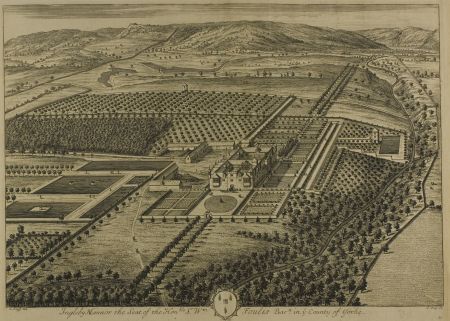
The red deer park and the fallow deer park were valued at £100 p.a. in 1657 (KA U1886 E8) and confirms they were both in Ingleby, as rents from ‘Greenhow Park’ were listed separately. The sale of wood in Greenhow and Ingleby in 1676 (KA U1886 E18) suggested that Sir David was making changes to the landscape and also raising revenue, as he was to paid £414 for the wood. About 760 trees were to be taken from the West Wood in the western part of Greenhow. A further 50 were to come from Ingleby Park, with 15 of these from Hagg Wood west of the Hall. Foulis had held a number of public positions, including becoming the MP for Northallerton in 1685, so it is possible that he had the funds and the desire to develop the gardens around the hall as shown in the drawing by Johannes Kip (Figure 4).
Kip published the image in 1707 but it may well have been drawn a few years before that. The layout is typical of the ‘French-Dutch’ style of the later 17th century with its formal gardens around the house, regular areas of trees (possibly orchards) and rectangular pools of water, one of which has a duck house. There is also a possible summer or banqueting house to the south west overlooking another formal pool and perhaps this is in the area where the trees were felled between 1676 and 1680. Immediately south west of the hall is an area that was probably the kitchen garden. In the wider landscape, the park walls are clearly visible and in the large enclosed area there are two areas of water, one a formal shape, the other more natural. Deer are depicted in the open parkland to the south, showing that it was still in use for that purpose.
1707 – 1854
Sir David’s son, William, was in possession of the estate when the Kip picture was published. Towards the end of his tenure in 1741, fashions had started to change not least because of the cost of maintaining the highly formal gardens. By the time his grandson, Sir William III, inherited in 1756, he may well have wished to update the designed landscape. More land had been acquired in Ingleby in 1740 by his grandfather but this was only 15a (KA U1886 T5). More purchases were made in 1764, 1767 and 1768 totalling 32a (KA U1886 T6, 7 & 8). Sir William also commissioned two maps of his estates at Ingleby (KA U1500 P19) and Greenhow (KA U1500 P18). These were made in 1762 and although they were ‘carefully taken from a former map to this scale’, it must be assumed they are a reasonable depiction of the land at that time.
The map of Ingleby (Figure 5) shows that the southern deer park had reduced in size with the western half now divided into fields. The avenue of trees leading to the southern entrance of the hall was missing, as well as the large planted areas to the southeast. Although the building, thought to be the summer or banqueting house remained, the formal pool next to it had gone. Although there is not enough detail to be sure, the formal terracing with its walks may also have been dismantled. The five formal ponds remained to the east but the double avenue of trees to the north appeared to have disappeared. There are pencil annotations marking possible changes and it is clear more parts of the deer park were to be divided into fields in the eastern most part in Ingleby Bank.
The map of Greenhow showed most of the area divided into fields with various farmsteads that are still there today including How Hill or Folly Farm, Wood End Farm, Bonny Hill Farm, Low Farm, Beck Farm and Water Beck Farm. From the bottom of West Wood, there was a wall shown on the western boundary, passing through ‘Cushat Gate’ and ‘Haggs Gate’ (latter marked as road to Helmsley) as far south as Jackson’s Bank (NZ 58440 02721). There was also a wall on the southern eastern boundary from the southern tip of Ingleby Park, apparently enclosing an open area in Greenhow Bottom of c. 100 acres. Both these walls would appear to be too far away from other likely parts of the medieval deer park, so may be later additions i.e. in the 17th century when Greenhow became part of the wider Ingleby estate.
The tithe map from 1839 (TNA IR 30/42/196, Figure 6) showed that the area south and east of the ponds east of the hall had been replanted and there was now a shelterbelt running north from it to Ingleby village. The courtyard to the north had been removed and there was no longer a carriageway direct to the hall. Only three large and one small pond remained to the east of the hall. There were possible remnants of the earlier terracing and the summer or banqueting house. The current walled kitchen garden was shown, which had been part of the previous complex of gardens. All of the former deer park of Ingleby was now divided into fields. In Greenhow, plantations now extended to the boundary in East Wood and the southern part of Greenhow Bottom.
By 1853/4 when the 1st edition 6” OS map was surveyed (Figure 7), a new carriageway to the west front of the hall was in place and the enclosed area around the summer or banqueting house had been removed together with the terracing. The kitchen garden had been extended with a new wall constructed to the west. Only one large pond remained and all the area to the north of it remained as open parkland. To the south, although labelled as ‘The Park’, it was still divided into fields and the new railway ran through it to the east.
Later history
Following her father’s death in 1845, Mary inherited the estate and in 1850 she married Lord De L’Isle, whose principal residence was at Penshurst Place in Kent. However Ingleby Manor remained an important place for Mary and she resided there permanently after the birth of her youngest child in 1860. During her tenure, there were significant changes made to the designed landscape, principally restoring the southern area to parkland. Former fields were planted with cover for game such as ‘His Lordship’s Covert’ and ‘Thistle Covert’ and the area in between was described as ‘The Warren’ on the 1st edition 25” OS map surveyed in 1892 (Figure 8).
In Greenhow, two more coverts were added in the open fields to west, which together with the old plantations to the west and open fields in the middle, provided good hunting ground for the de L’Isle family. Sir Henry Foulis (brother of Sir William and Mary’s uncle) was reported to have kept a pack of harriers (used for hunting hares) but Lord de L’Isle was said to keep no hounds (Fairfax-Blakeborough 1907, 85). He was not keen for local hunts to use his land (ibid, 91), as presumably he preferred shooting game. These areas remain largely unchanged.
Location
Ingleby Manor lies just south of the village of Ingleby Greenhow and is just over 3.5 miles (6 km) southeast of Stokesley.
Area
Ingleby Manor and its associated park was c. 550 acres at its greatest extent in the early 17th century (see Section 3.2 & Figure 1). The size of the medieval park of Greenhow is unknown but likely to be no more than 300 acres with the later ‘Lawns Hill’ and ‘Jennat How Hill’ (possibly a corruption of ‘jenne’ or gin, meaning snare to catch rabbits) included.
Boundaries
The western boundary of the Ingleby Manor’s historic park starts adjacent to the Church near Church Lane and continues south following the woodland and then park wall to NZ 591 047. The southern boundary is marked by the southern edge of Park Plantation. The latter’s western edge provides the boundary to NZ 599 058. It then follows the old park wall north to NZ 596 065, past Whitley Hill to the road at NZ 592 071. The northern boundary then follows the road east to the junction with the road leading to Bank Foot. Then from NZ 587 064, it continues east until The Parson’s Plantation and onto the Avenue Plantation.
Landform
The underlying bedrock is Redcar Mudstone Formation across the lowland parkland and plantations on the hills next to it. This is overlaid with deposits of uneven sized glacial tills giving rise to slowly permeable, seasonally wet slightly acid but base-rich loamy and clayey soils.
Setting
Ingleby Manor is in the North York Moors National Park Authority’s Landscape Characterisation Area of the Cleveland Foothills. This is characterised by a distinctive, steeply graded escarpment landscape forming an outward facing transition area between the moorland of the Cleveland Hills and lowlands of the Cleveland Plain. The Ingleby Manor estate lies just on the boundary between these two areas, with the surrounding hills forming a spectacular ‘borrowed landscape’. Ingleby Manor itself is at 141m AOD on a flat piece of ground that then rises sharply to the east from 150m to 350m OD. To the south, it rises to c. 160m OD at the park wall. To the north, it falls from 140m AOD at edge of pleasure grounds next to the hall to 121m AOD at the northern boundary.
Entrances and approaches
The main entrance to Ingleby Manor has always been from the village next to the church. There are currently entrance gates here although the date of these is unknown. From the entrance a carriageway leads south to the main building through woods. Originally this went to the north entrance of the hall through a set of inner gates, with another route to the adjacent service buildings. By the early 19th century, the main entrance to the hall was moved to the west with the removal of the northern courtyard.
Principal buildings
Ingleby Manor [Grade II* - NHLE 1314888]
Built c. 1550 by William, 2nd Lord Eure and modified in succeeding centuries, with main entrance moved from north front to west front in the late 18th/early 19th century.
Stables [Grade II – NHLE 1151386]
Late 18th century with later alterations on site of earlier service buildings shown on Kip picture
Icehouse
To southwest of walled kitchen garden at edge of High Plantation. Not marked on any OS maps. Mound covered in earth with small brick-lined interior. Visible bricks late 18th or probably early 19th century, so could date from then or be remodelled in this period.
Game larder
Abutting the northeast part of Ingleby Manor and adjacent service buildings. Probably built in late 18th or early 19th century.
Building [possibly Summerhouse or Banqueting House]
This is shown on the drawing by Kip c. 1707 next to the beck southwest of the hall. It appeared to remain in-situ until the mid-19th century.
Building
At the southern edge of the walled orchard was a prominent building that may be a dovecote or perhaps a viewing spot for the adjacent park and shown on the Kip drawing. It had been removed by 1762.
Gardens and pleasure grounds
Late 17th gardens
The drawing by Kip (Figure 4) shows a series of enclosed garden areas surrounding the hall to the north, west and east. While these might be stylised, they show the use of gravelled areas, grass plats, topiary and regular planting of small trees. The terraces to the west were designed to take advantage of the view down towards the beck and across to Greenhow. Immediately south of the hall, there appears to be a sunken area that may have been a bowling green.
Later gardens
There is a description in The Gardeners’ Chronicle of 26 August 1893 (234) of the gardens:
The flower – garden is between the house and the kitchen – garden, separated from it by an Ivy-clad wall. The garden is small, but very bright with old-fashioned flowers and modern border Carnation. The kitchen garden is not only useful but ornamental. The low wall that divides it from the flower-garden is covered with old-time Roses, like centifolia rosea, and the border on the valley side of the garden is planted with old Roses, chiefly York and Lancaster. The centre walk up to the sundial in the middle of the garden has by its sides a Yew hedge, about a foot high, into which are cut squares. On the other side of the dial, the path is lined with herbaceous borders; the bright colours of the flowers were seen to advantage, owing to the sunny day. Rose trees were frequent in the borders, and were producing some very shapely deep-coloured flowers.
Kitchen garden
Lying due south of the main building, it was originally part of the formal garden complex of the early 18th century. While other parts of the gardens were removed, it stayed in place. It was expanded to the west some time in the first half of the 19th century.
There were 2 small glasshouses on northern and southern walls and the interior by 1893 also had ornamental areas described in Section 4.8.2. In addition, there were ‘heavy crops of all kinds of culinary vegetable…Bush fruits were loaded with fruit, especially the Black Currants; and there was a good crop of Apples on the young trees’ (ibid).
Park and plantations
Ingleby Park
Created in the late 16th century to complement the newly built Ingleby Manor, it used previously enclosed moorland, namely the ‘Great Intack’ and the ‘Lesser Intack’. Figure 1 shows its likely extent in 1608, when a survey was made of it prior to Foulis’ purchase. While it contained two areas for fallow deer and red deer, it was also used for the grazing of domestic animals such pigs and cattle.
Greenhow Park
A medieval deer park c. 100-300 acres that probably stretched from West Wood to the boundary with Ingleby to the east and including ‘Lawns Hill’ and ‘Jennet How Hill’.
The Avenue [Hagg Wood]/High Plantation
A strip of woodland encompassing Ingleby Beck and bordering Greenhow. The northern part (‘Hagg Wood’) dates back to the late 16th century and was part of Ingleby Park. Later renamed as ‘The Avenue’, it had been extended by 1762 with the southern section named ‘High Plantation’.
Park Plantation
In the south east of Ingleby Park, this first appears as a small plantation on the Kip drawing and on the 1762 map. By tithe map of 1839, it had expanded to 133 acres. By 1952, it had been largely cleared. The area to the west has since been replanted and has been extended to the north.
West Wood
On the boundary next to Great Broughton, this has parts of some very ancient woodland from at least the 12th century. It was possibly later incorporated to form a natural boundary with the open areas of Greenhow Park to the east. The B1257 road from Great Broughton to Chop Gate now cuts through it.
East Wood/Hoggart’s Wood
This was possibly created in association with Greenhow Park in the mid-14th century. It was extant by 1762 and had expanded westwards to the wall by 1839. By 1890, it had reduced in size to the south and had been renamed ‘Hoggart’s Wood’.
Midnight Wood
To the south of West Wood, it is also shown on the 1762 map extending as far as West Wood. By 1839, this had been thinned out to create more pasture and the wooded area reduced.
Water
Series of ponds west of hall
The Kip picture shows 5 rectangular pieces of water east of the hall, including one that had a duck house and another with 2 small islands. They were still extant in the early 19th century but only one remained by 1853 and exists today. It is lined with stone and was perhaps kept to provide ice for the icehouse.
Ponds in former deer park of Ingleby
Both of these may well have served as fishponds. In addition, the more irregular one with its ‘arms’ may have been created as a duck decoy pond. It is not shown on the 1762 map, so may have been abandoned by this stage. The other more regular pond was created from a possibly manmade stream or canal that flowed from the hills later called ‘The Race’. It has a building next to it, possibly a hide from which to shoot from, but whether it had any other function is unknown.
Books and articles
Atkinson, J. C. (ed) 1885. Quarter Session Records, Volume III. The North Riding Record Society.
Atkinson, J. C. 1892. ‘Where and What was Camisedale?’, The Reliquary Quarterly VI (New Series), 70-77.
Blackburne, J. 1889. The Parish Registers of Inglebye iuxta Grenhow. Canterbury, The Canterbury Press.
Brigg, W. ed. 1915. Feet of Fines for the Stuart period, Volume 1, 1603-1614. Leeds, The Yorkshire Archaeological Society.
Fairfax-Blakeborough, J. 1907. England’s oldest hunt: being chapters of the history of the Bilsdale, Farndale and Sinnington Hunts. Northallerton, the author.
Ord, J.W. 1846. The History and Antiquities of Cleveland. London, Simkin and Marshall.
PRO 1857. Calendar of State Papers Domestic Series in the reign of James I. London, HMSO.
PRO 1894. Calendar of the Patent Rolls, Edward II, 1307-27. London, HMSO.
PRO 1895. Calendar of the Patent Rolls, Richard II, 1377-81. London, HMSO.
PRO 1906. Calendar of the Charter Rolls, Vol. II 1257-1300. London, HMSO.
PRO 1911. Calendar of the Fine Rolls, Vol. III, Edward II, 1319-27. London, HMSO.
PRO 1913. Calendar of Inquisitions Post Mortem: Volume 8, Edward III. London, HMSO.
PRO 1916. Calendar of inquisitions miscellaneous (Chancery). London, HMSO.
PRO 1938. Calendar of Inquisitions Post Mortem: Volume 12, Edward III. London, HMSO.
Surtees Society. 1887. Cartularium abbathiæ de Rievalle, Publications of the Surtees Society Vol. 83. Durham, Andrews & Co.
Primary sources
Borthwick Institute of Archives (BIA)
CP. G. 81 Testamentary (validity of will), 3/10/1517 — 18/4/1523 (Greenhow Park farmhold)
CP. G. 508 Dispute re tithes, 17/11/1552 between Henry Warcop, plaintiff and William Robinson, defendant
CP. G. 538 Dispute re tithes, 17/11/1552 – 21/7/1553 between Henry Warcop, plaintiff and William Ridley, defendant
Kent Archives (KA)
U1886
E1 Survey of lands in Battersby and Ingleby , 1610
E8 Particular of the estate of Sir David Foulis, 1657
E18 Sale of timber in West Wood, Greenhow, 1676
E44/3 Particular of Ingleby Park, 1608
E44/22 Extract of survey of lands of Lord Eure, 1576
T3 Deeds of lands in Ingleby, 1449
T10/1-2 Deeds of lands in the Upper Field of Ingleby abutting on the Red Deer Park Wall, 1609 & 1612
T15/1-10 Chapman estates in Greenhow, 1335-1600
T19 Rent out of Greenhow (capital messuage), 1638
U1550
P18 Map of the Estate of Sir William Foulis at Greenhow by Thos. Hammon, 1762
P19 Map of the Estate of Sir William Foulis at Ingleby by Thos. Hammon, 1762
The National Archives (TNA)
IR 30/42/196 Tithe map for Ingleby Greenhow, 1839
Maps
Ordnance Survey 6” 1st edition, surveyed 1853 to 1854, published 1857
Ordnance Survey 25” 1st edition, surveyed 1892, published 1893
Figure 1 – Extent of Ingleby Park in 1608 on 1st edition OS map of area. Reproduced with permission from the National Library of Scotland.
Figure 2 – ‘Lawns Hill’ on OS 6” 1st edition map, surveyed 1853 to 1854, published 1857. Reproduced with permission from the National Library of Scotland.
Figure 3 – Possible position of medieval shooting lodge at Greenhow on the map of the Estate of Sir William Foulis at Greenhow by Thos. Hammon, 1762. Copyright The Viscount De L’Isle CVO MBE, Penshurst Place, Kent.
Figure 4 - Ingleby Mannor, plate 60 from Britannia Illustrata, published 1707. Artist: Jan Kip (Dutch, c. 1653-1722), published by David Mortier. Ref. 2009.167, Art Institute of Chicago - https://www.artic.edu/artworks/198932/ingleby-mannor-plate-60-from-britannia-illustrata
Figure 5 – Ingleby park on the map of the Estate of Sir William Foulis at Ingleby by Thos. Hammon, 1762. Copyright The Viscount De L’Isle CVO MBE, Penshurst Place, Kent.
Figure 6 – Ingleby Manor and surrounding gardens and parkland from the tithe map for Ingleby Greenhow, 1839 (TNA IR 30/42/196). © The National Archives.
Figure 7 - Ingleby Manor and surrounding gardens from OS 6” 1st edition map, surveyed 1853 to 1854, published 1857. Reproduced with permission from the National Library of Scotland.
Figure 8 – Restored parkland and new coverts south of Ingleby Manor from the OS 25” 1st edition, surveyed 1892, published 1893. Reproduced with permission from the National Library of Scotland.
All documents from the Kent archives are courtesy of Lord De L'Isle of Penshurst Place.


